| Report Type | Full |
| Peak(s) |
Maroon Peak - 14,163 feet |
| Date Posted | 11/19/2023 |
| Modified | 10/27/2024 |
| Date Climbed | 09/02/2023 |
| Author | The_Ramp |
| Additional Members | Checkers_hello |
| 3 Days in the Valley of Titans: Maroon Peak |
|---|
|
DISCLAIMER: This Trip Report is one of three associated with our experience climbing Pyramid Peak, Maroon Peak, and North Maroon Peak over three consecutive days in September 2023. This TR focuses specifically on our climb of Maroon Peak, though some information, including the introduction/conclusion, parking and camping logistics, and closing reference material are shared across all three TRs. I have also embedded links for the complimentary TRs within this report for easy cross reference. For background as to why I've started documenting my 14er expeditions, see my 2022 Capitol Peak Trip Report. Thank you for reading. 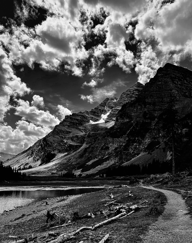
INTRODUCTION My buddy and I successfully climbed Pyramid Peak, Maroon Peak, and North Maroon Peak over three consecutive days from 1 September to 3 September 2023. We climbed via the Standard Routes from the Maroon Lake TH (Pyramid Peak) or from our campsite at Crater Lake (Maroon Peak and North Maroon Peak). Furthermore, we did NOT do the Maroon Bell traverse but elected to ascend/descend both peaks individually. This was a huge weekend involving nearly 35 miles of hiking and over 12,000 vertical feet of climbing. We were blessed with amazing weather, supportive family, and friendly fellow climbers that made this trip truly special. Each of these mountains represents a VERY serious climbing effort. All require excellent fitness, significant route-finding skills, and comfort on incredibly loose and exposed rock. Combining them into a single weekend compounded these factors and placed further emphasis on our pre-trip preparation. In addition to our experience base and fitness regimens, my partner and I studied countless 14er.com user Trip Reports for all three peaks, attempting to consume every trail nuance, route-finding tip, and climber lesson learned. More than a tricky set of moves or intense exposure, nothing disrupts my comfortability like being surprised on a climb. Please utilize those that have gone before; this website is an absolute treasure in helping prepare climbers for a successful day on these peaks. I've linked what I found to be the most helpful Pyramid Peak, Maroon Peak, and North Maroon Peak user TRs and photos throughout my report below. This includes a number of photos from the "Photo Stash" tab on the respective peak Route Description pages, a welcome aspect for these mountains considering some of the other 14er web pages don't have any photos in their "Stashes.” I included all the raw links along with some other useful information at the end of the report. But before even stepping foot on the trails for each of these amazing peaks, we had to overcome the daunting logistics associated with accessing this area of Colorado. For better or for worse, driving to the Maroon Lake TH and camping in the Maroon Bells Wilderness are both heavily regulated. Therefore, in addition to documenting our experience climbing, I delve into exhaustive detail managing all these logistics. It’s a lot. It’s too much. To skip ahead to the climbing portions of this TR, just scroll down to the first photo below. Reach out with questions. Thank you for reading. LOGISTICS To maximize our experience climbing Pyramid Peak and the Maroon Bells, our baseline plan was to park our car at the Maroon Lake TH and then pack in and camp at one of the Crater Lake designated campsites. This would allow us to have great access to the 14er climbing routes as well as provide a “home base” in between difficult summit bids without unnecessary hiking and/or driving each day. This approach, however, required significant logistical planning months in advance. Our plan required two separate, pre-purchased reservations:
Please note: everything below is based on my experience in 2023. All are subject to change year over year. Also, I do have some...reservations (pun intended) about our approach for managing these logistics which I expand on a little later in this section. MAROON LAKE TH PARKING PARKING PASS RESERVATION SYSTEM Visitors to the Maroon Bells Scenic Area cannot simply drive to the Maroon Lake TH and park; there are very strict access regulations in place during the summer and autumn months. From mid-May through October, no personal vehicles are allowed access up the road between 0800 and 1700 MT. All visitors during this time are required to take a shuttle which requires a pre-paid reservation (bikers, e-bikers, and pedestrians are excepted). The road is open outside of that time window, but in order to park a personal vehicle at the TH, a pre-purchased parking pass is required. There are multiple parking pass types, including day/evening parking, 24-hour parking, and the most coveted: a 60-hour parking pass. Parking passes cost $10, regardless of type (unless you have an “America the Beautiful Pass” or a “Maroon Bells Annual Pass,” in which case the parking fee is waived). All Maroon Bells Scenic Area shuttle and parking reservations are made via the Aspen Chamber Resort Association (ACRA) Maroon Bells Reservations web page. The ACRA Maroon Lake TH parking system has a rolling reservation release meaning parking/shuttle reservations for set blocks of dates are made available starting on a specific date and time months in advance. For example, for parking/shuttle reservations in the months of July and August 2023, the website reservation window opened on 1 April 2023 at 1000 MT. With the goal to knock out both Maroon Bells and Pyramid Peak in a single trip, the 60-hour parking pass was the obvious choice for us. But because my climbing partner and I both have busy lives including families with young children and variable work commitments, not to mention wanting to ensure a good weather opportunity, there was no way for us to predict the exact dates that would work for us months in advance when the parking reservations opened. That left us playing the game of selecting multiple date opportunities, all centered around weekends in August and September 2023, and then making several different parking reservations when the respective rolling reservation windows opened. I have a few notable observations about the ACRA website and booking parking reservations. On both reservation release dates that we used, the web page started accepting reservations 5-10 minutes earlier than the advertised 1000 MT opening time. I was lucky enough to be actively monitoring and able to take advantage of this early release. But no doubt some unlucky users would have opened the website at exactly 1000 MT to find their desired parking dates were already booked. Once I selected the desired dates, the ACRA website was very efficient in progressing through my information and payment, though I did do a “practice run” beforehand on some available dates earlier in the summer and was therefore familiar with the interface. Because of this, I was able to knock out a handful of parking reservations in a matter of minutes. Furthermore, I did NOT receive a confirmation email or notification after I booked the reservation! The only indication that I was successful was a confirmation web page that had a “Printer Friendly” link. I left these confirmation pages open on new browser tabs until I had completed booking everything I wanted, then printed all the confirmation pages to PDFs and saved them to my computer. This is important because as far as I could tell, there was no way to access my reservations via the website after I made them. Either I missed something (maybe the email got stuck in my “Junk” folder?) or this is a serious deficiency in the ACRA website/booking system. All 60-hour Maroon Lake TH parking passes for summer weekends were booked within 5 minutes of the respective reservation windows opening. All 60-hour Maroon Lake TH parking passes for the entire months of July, August, and September were booked within 24 hours of the respective reservation windows opening. There were a handful of day reservations (both 12-hour and 24-hour), mostly for weekdays, lingering for a few weeks. In total, my partner and I made seven different 60-hour Maroon Lake TH parking reservations for various weekends in August and September 2023. Of course, we did not use all of these reservations. When our plans came together later in the summer, I offered most of my unused reservations to other users on 14ers.com. This is an easy transfer to do since each parking pass has a unique number (versus being tied to an individual's name or vehicle). I say “most” because in error I had printed the wrong reservation confirmation page on two of them (remember: I received no email confirmation and without an email, there was no way for me to access my previously made reservations). So, a couple of our reservations went unused… which sucks. Again, I believe there is a serious deficiency in the ACRA website in this regard; I would have happily cancelled or found a home for these passes but had no way of accessing them again. Hopefully whoever was up there those weekends noticed a single car less of people in the area. In the end, as our dates for our climbing trip aligned, we were left with a 60-hour reservation starting 0600 MT on 2 September 2023 until 1800 MT on 4 September 2023. I also scored a 60-hour reservation starting at 0600 MT on 31 August 2023 from a fellow 14ers.com member that helped us start our weekend a day earlier which was extremely helpful to our personal commitments (and happened to make for a much better weather window as well). Thank you to user "brousseau" - this community rocks! MAROON LAKE PARKING EXPERIENCE With our Maroon Lake TH parking passes in hand, we arrived in Aspen via Independence Pass around 1900 MT on Thursday, 31 August 2023, and, after a quick pit stop for a half hour in the Aspen Rec Center parking lot to get our gear organized, we ventured further up the Maroon Creek road. We by-passed the cones surrounding the unmanned welcome station and after ogling the gigantic profiles of Pyramid Peak and the Bells from the road in the dark, we pulled into the Overnight Lot at the Maroon Lake TH without issue. We taped both parking permits to the windshield (we had two separate 60-hour passes - see above) and quietly retreated to our sleeping bags for a restless few hours of sleep. I believe sleeping in a vehicle in the Maroon Lake TH Overnight Lot is technically not allowed and have read stories of Rangers tapping on windows of vehicles during the night. But no one bothered us. We also heard some other, less-quiet parties attempting to do the same thing while bedding down. Following our successful Pyramid Peak summit bid the subsequent day (Friday, 1 September 2023), we returned to our vehicle to get our backcountry gear. We had no issues with accessing the vehicle again and we did not see any authority inspecting parking pass permits for the hour or so we were at the car. I also noticed a few cars in the Overnight Lot that did NOT have a parking pass on their dashboards. Those same cars were there upon our return two days later with no obvious violation as far as I could tell. I know for folks with half-day or full day parking permits, displaying the permits on their vehicle dashboard is not required, but those cars are supposed to park in the adjacent Day Use Lot versus the Overnight Lot. All to say, for the few cumulative hours we were in the Maroon Lake TH parking lots across our trip, I saw no one policing permits nor any sort of obvious consequence for vehicles not displaying a parking pass. As far as I can tell, I’m not sure what is stopping someone without any permit from accessing and parking at the TH in either lot, assuming they arrive outside the restricted hours. The only other observation I have is that both the Day Use and Overnight Lots were very full when we exited Sunday. I suppose it wouldn’t take much if both lots are over-prescribed for a Ranger to ascertain that someone is there who shouldn’t be. CRATER LAKE OVERNIGHT PERMIT OVERNIGHT PERMIT RESERVATION SYSTEM New for 2023 is a required overnight permit associated with various backcountry areas in the Maroon Bells-Snowmass wilderness, including the 11 designated campsites surrounding Crater Lake. Reservations for “Maroon Bells-Snowmass Wilderness Overnight Permits” can be made at Recreation.gov, which I have used frequently in the past to secure other Colorado campsites. On the permit web page includes useful information and maps, including this one which shows all the Maroon Bells-Snowmass permitted zones as well as this one which outlines the specific Crater Lake campsites. Similar to the Maroon Lake TH parking pass, the overnight permits were released on a rolling basis. For our targeted weekends in August and September 2023, the reservation system opened on 15 June 2023 at 0800 MT. There are some additional restrictions associated with these permits worth noting:
As was the case when we booked our Maroon Lake TH parking passes, at the time when the Crater Lake campsite permits became available, we did not know our exact climbing dates and were attempting to maximize our flexibility. Our plan was to reserve the maximum allowable number of reservations each (two) for four separate weekend dates in August and September 2023. So on the morning of 15 June 2023, the day the overnight permit reservations opened for August and September 2023, my buddy and I were situated in front of our respective laptops and ready with the F5 key as if we were buying concert tickets. As advertised, the dates became available for reserving at 0800 MT sharp. The Recreation.gov reservation system is a little confusing, including some intense selection and scrolling to find the right permit zone, desired campsite, and dates. And there are a lot of seemingly unnecessary inputs (livestock Y/N, entry/exits points, alternate permit holders, etc.) to complete the reservation, but having done a practice run, we were both familiar with the necessary information and made quick work of booking everything successfully. All Crater Lake overnight permits for weekends in August and September 2023 were booked within 30 minutes of the reservation window opening. Contrary to the ACRA webpage for Maroon Lake TH parking permits, we received reservation confirmation emails following our successful bid for sites. Additionally, I could log into my Recreation.gov account at any time and access my permits. Once our climbing dates solidified, we both cancelled our unused permit reservations. It is difficult to "unofficially" transfer the reservations to someone else (such as a fellow 14ers.com user) like you can with the parking passes because it clearly states on the overnight permit reservation that the personal identification of the individual occupying the campsite needs to match the name on the permit. And you can't change or add permit holders without cancelling and re-booking the reservation. One additional comment on the Crater Lake Overnight Permit reservation system: in the confirmation email there is a link to “print a parking pass" for the Maroon Lake TH. This is NOT a free or included Maroon Lake TH parking pass but instead just a link to the ACRA webpage for the specific dates of the overnight permit, which in our case were all completely sold out since the parking reservation system opened 6 weeks previously. So don’t depend on the overnight permit to provide you a Maroon Lake TH parking pass – you will need to book those separately and earlier than the camping permit. CRATER LAKE CAMPING EXPERIENCE My buddy and I were a little concerned that when we arrived at our designated Crater Lake campsite on the first day of our permit reservation (1 September 2023), we would find someone occupying the site. But after summiting Pyramid Peak and meandering our way up from the main West Maroon Pass trail at Crater Lake, we found our reserved Campsite #4 completely empty and ready for us to move in. For this trip, I elected to bring my bulky 4-man tent versus a smaller 2-man backpacking tent knowing it was a short trip from the Maroon Lake TH and to give us some more room to spread out. I actually carried the tent that morning to the Pyramid Trail turn-off before stashing it in the trees, then retrieved it after our summit bid when we went to scope out the site. Campsite #4 is large and if it’s any indication of the other Crater Lake sites, one could easily fit a larger tent or multiple small tents at these sites. All of the Crater Lake campsites are set back from the West Maroon Pass trail a bit (see map) and we continued our running joke from last year’s Capitol Lake campsite experience that the hardest part of our day, regardless of how many miles we hiked or vertical feet we climbed, was the seemingly endless slog up to the campsite from the main trail. We attached a tape-wrapped copy of our permit to the outside of the tent and left it there for the duration our stay. As for water, we filtered at the Minnehaha Gulch stream a few hundred yards further along the West Maroon Pass trail (southwest) from Crater Lake (between Campsites #3-5 and #6-8) which is super accessible and preferable to attempting to filter the silt-filled Crater Lake water. But this of course required additional soul-crushing trips up and down the Campsite #4 access trail. During our entire 2.5 day stay at Crater Lake Campsite #4, we never saw a Ranger or anyone policing the campsites, though I suppose they could have been making rounds while we were climbing during the morning/early afternoon hours. In fact, the adjacent campsites to ours were mostly empty. However, on our second day (Saturday, 2 September 2023), a group of guys set up in Campsite #5 in the late afternoon. By the way they were scoping everything out and purposefully avoiding interaction with us, we could tell something was fishy. Furthermore, there was a rather loud argument between two of them resulting in one of the guys shouting to his companions “I’m going home! Thanks for nothing!” before storming off. It was awkward. To add to the drama, a few hours after they had set up their tents, another backpacker wandered in claiming to be the “true owner” of Campsite #5 for that night. There was some discourse, but they apparently made it work and just shared the site for the night. I only bring this up because while we were relieved when no one was situated in our reserved Campsite #4 when we arrived, it clearly does happen and could result in a complicated situation. And with no observed Rangers policing the sites, I’m not sure what recourse there was if we had run into a stubborn squatter in our site. Upon returning from our final day of climbing, Campsite #5 was once again completely empty, so maybe they did get the boot from the local authority. My only other comment related to the Crater Lake camping situation is that a bear cannister is required for all overnight stays in the Maroon Bells-Snowmass Wilderness areas. There are signs plastered everywhere around the Maroon Lake TH reminding people of this fact. I have heard stories of Rangers checking backpacks for cannisters, but we were never approached. (We did of course have and appropriately used a bear bin) LOGISTICS – FINAL THOUGHTS I do have some conflicted feelings about our approach in managing these logistics, especially with how we hoarded multiple parking and camping reservations months in advance without knowing which ones we would actually use. But I'm not sure there's a better or more efficient way to do it with so much uncertainty and flexibility baked into our trip. Both the Maroon Lake TH parking passes and Crater Lake overnight permits were relatively inexpensive so even if I wasn't able to re-coup the cost of those investments (which was the case for a couple of the parking passes due to the lack of cancellation ability on the ACRA website), it didn't represent a significant financial loss. And it was nice to know that we had a reserved campsite waiting for us rather than hoping and praying something was available after lugging all our gear up to Crater Lake. Finally, given how insanely popular the Maroon Bells Scenic Area is and seeing the hordes of people up there on a holiday weekend, I do appreciate the rules and knowing their intent is to protect these incredibly special wilderness areas. I was a little underwhelmed by the lack of accountability observed at both the TH parking lots and the campsites, but maybe the local authorities take the same approach that big retailers take with theft: if they can deter 95% of the unwanted behavior, they'll live with the 5% that gets through. All that being said, given how much effort we exerted (and anxiety I had) in navigating these logistics, I was very pleased with how everything came together and worked out. In summary, to ensure success in managing the logistics associated with accessing the Maroon Bells Scenic Area, I recommend climbers:
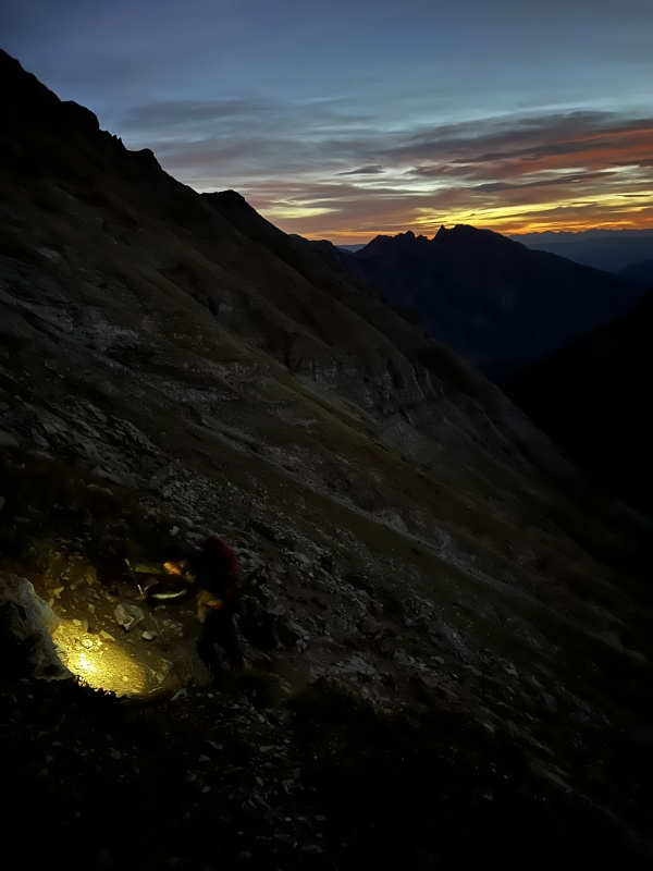
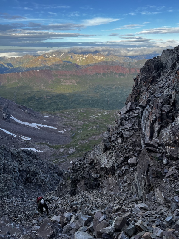
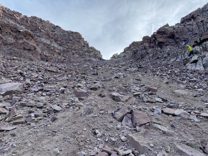
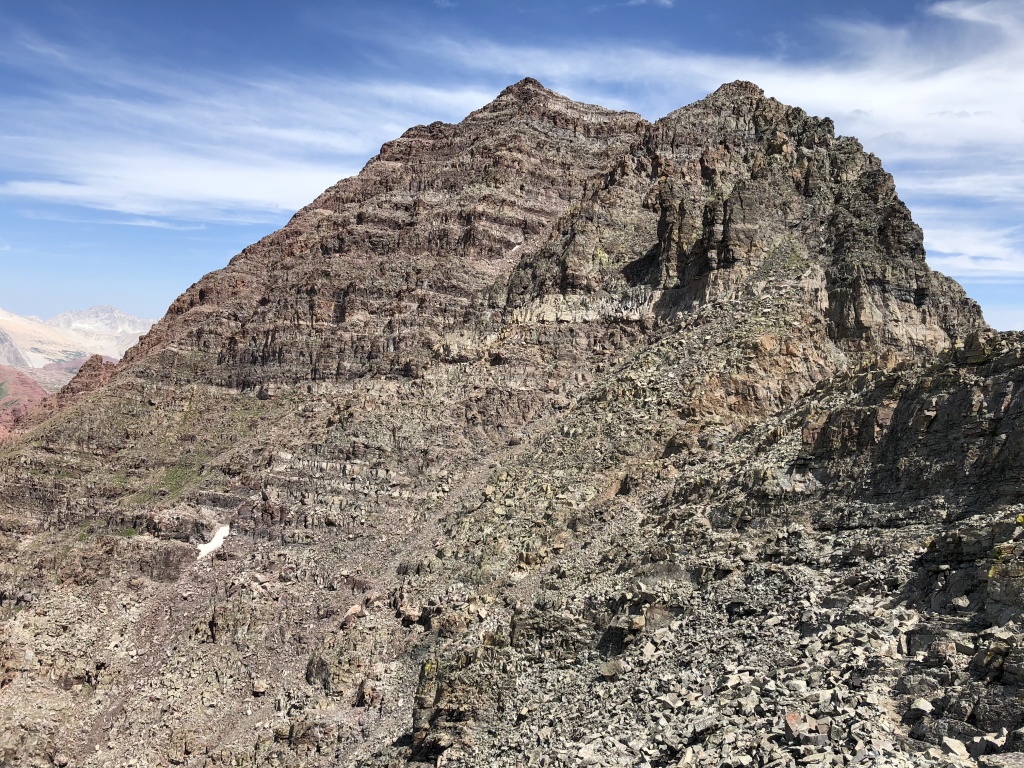
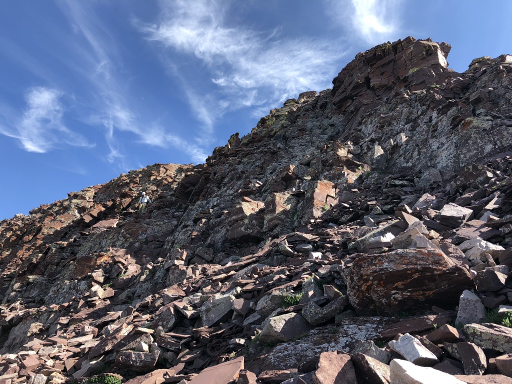
Ok, enough of all that; onto the fun stuff. DAY I: PYRAMID PEAK Pyramid Peak TR (1 September 2023) DAY II: MAROON PEAK A GPS HUMBLING & THE GREEN MONSTER In the early hours of 2 September 2023, my climbing partner and I lay awake in our tent at Crater Lake Campsite #4, tossing and turning on our sleeping pads. We crashed hard and early the previous evening after our Pyramid Peak summit bid and I'm not sure why we didn't just get up since we were both obviously awake. Maybe we were both dreading what we knew to be the longest and likely most difficult climb of our trip. Our alarms finally chirped at 0300 MT and after slowly getting dressed and retrieving our daily rations from the bear bin, we left our campsite at 0330 MT. The sky was clear, it wasn't too cold, and we were alone. I never climb with a GPS capability, partially due to a lack of caring to try and figure it out and a dubiousness on if it even is helpful or as exacting as needed. But mostly because I arrogantly like to use my wits and pre-climb research when navigating routes. My climbing partner has a nice Garmin watch though and knowing some of the trail branches in this area are hard to find, especially in the dark, we decided to load the 14ers.com GPX files into his device. My personal intent was to use them as a validation of my own trail navigation, which I believed to be one of my greatest climbing skills. I was vindicated somewhat on our previous day of climbing Pyramid Peak as I identified what was obviously the turn-off from the Crater Lake trail while my buddy's watch indicated we were still a few hundred yards away. (We discerned later that the GPX file was pointing us to the second Pyramid Peak trail split, the one closer to Crater Lake.) Add the fact that his watch was going ballistic in the Pyramid Peak Amphitheater due to the high surrounding walls preventing a signal lock and my skepticism in the effectivity of a GPS device only increased. But as the expression goes, there are two kinds of people in the world: those that are humble and those that are about to be humbled. The Maroon Peak route starts by hiking along the well-traveled West Maroon Creek trail for almost two miles beyond Crater Lake. This bit of hiking is mild but definitely foreboding in the dark as you almost feel the ominous and uncaring presence of the gigantic peaks looming over you. We were largely silent, both due to creeping exhaustion from a second big day in a row and also knowing what lay ahead. But as the blood starting flowing, our conversation picked up and we unknowingly blew right past the Maroon Peak turnoff. After giving my buddy such a hard time about his GPS watch deficiency the day before, he had silenced it and therefore we were none the wiser. Thankfully, after a quarter mile or so, he randomly checked his watch and called out my error. We backtracked and found the obvious cairn and trail start in a boulder field. Suffice it to say, I felt rather stupid for poo-pooing the technology that likely saved us an hour or more as I have no idea how far I would've led us before realizing we missed the trail. The Maroon Peak turn-off from the West Maroon Pass trail is located on the backside of a rock avalanche area and there was a large cairn identifying the split (along with, interestingly enough, a tree branch someone laid over the trail). The initial part of the Maroon Peak trail after the turn-off was relatively mild and had some helpful rock steps installed during the steeper parts. But after crossing a rocky gully, it was onto the main event: the "2,800 ft of suck" to reach Maroon Peak's south ridge. An Aspen Expeditions guide we met on Pyramid Peak the day before called it the “Green Monster" which I like better. And oh boy did this part of the route live up to both names. This stretch was steep, loose, and unending. We were climbing mostly in darkness and it was near impossible to see where we were headed other than the 25-50 ft in front of us. The dark head walls above us never reached any clarity or seemed to get any closer. There were also some rocky bits intermixed with the steep dirt paths that created some route-finding challenges, but even if we got off route after a series of scrambling moves, we always were able to pick up the trail again. After being passed by a couple of faster climbers, we crossed a shoulder on the left (southern) side of the Green Monster as the morning light began to fill the valley. There are two shoulders like this close to the top with more of the same difficult hiking in between. After the second shoulder, the trail turned completely north on the ridge proper. After this last stretch of "suck," we finally came into view of Maroon Peak and the remaining route up its western backside. It took us over 3 hours to get to this point from our Crater Lake campsite, most of that time spent toiling away on this behemoth pitch. (Note that I don't have the best photos of the Green Monster. See the awesome TRs from JQDivide and WildWanderer for better images of this area). 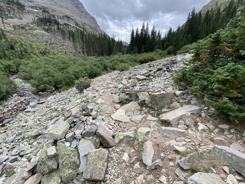
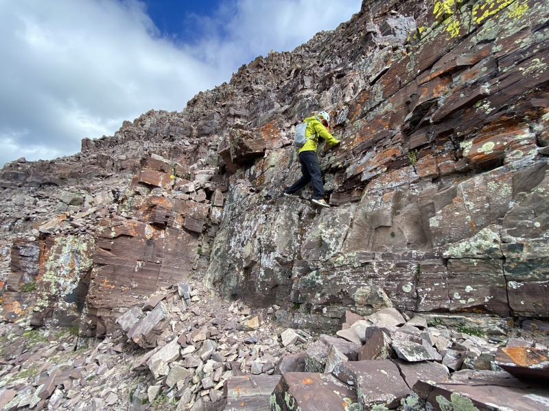
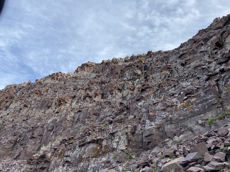
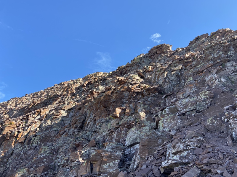
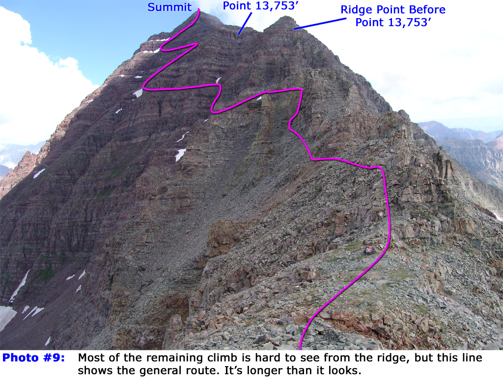
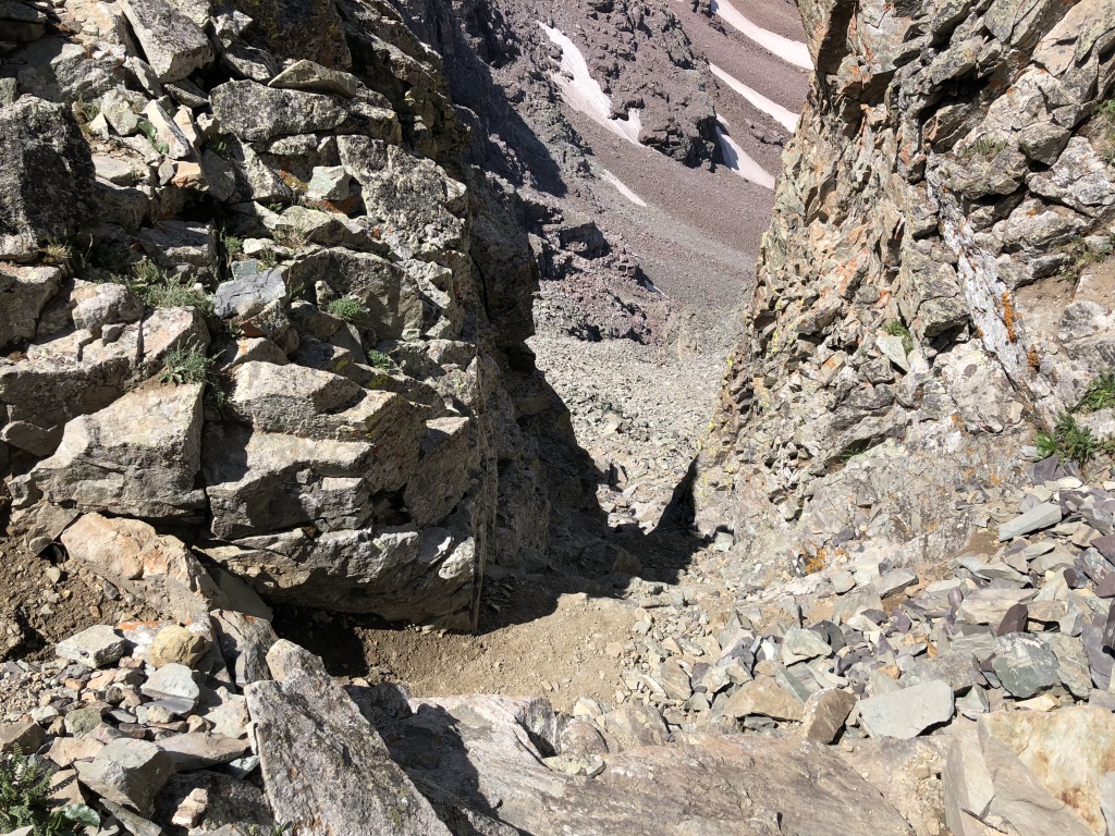
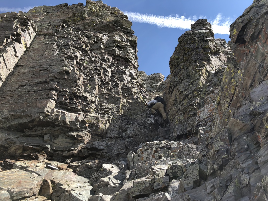
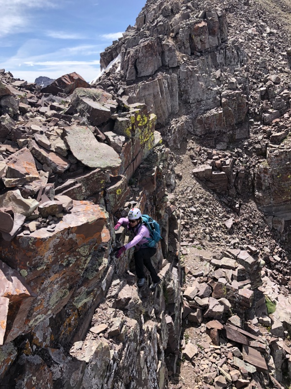
CHIMNEYS & THE TWO GULLIES After gaining the ridge above the Green Monster and finally seeing the day's objective, we shed the headlamps, had a snack, and took a collective deep breath to focus. Photo #9 from the Route Description shows the remaining route from this point. The Green Monster had been seriously exhausting and while we were glad to be finally to the "fun" part of the climb, it was definitely intimidating to know how much further we had to go. We started moving again and followed a very obvious trail on top and then on the western side of the of the ridge. The route kept us on the western side of Maroon Peak, and therefore in the shade, until the final summit scramble 2 hours later. Cairns led us along trail remnants to the base of the first Class 3 obstacle: a pair of chimneys. We climbed east up the first chimney, paused at the base of an obvious headwall, and then angled climber's left (north) to climb the second chimney. There are excellent holds and foot placements on both chimneys and the rock is super solid, which is interesting given how crumbly and loose the rest of the Maroon Peak route is. We did take turns up both sections, communicating frequently, as any rockfall would naturally funnel down the chimneys. There are some great images of the chimneys in Photo Stash tab on the Maroon Peak Route Description page, especially Photos #85, #86, and #88. Our traverse along the western side of the ridge line continued after the chimneys and the trail remained obvious with frequent cairns. This area is quite impressive given how absolutely rotten the rock is. At certain angles it looks like the entire mountain side is nothing more than a crumbling jumble of boulders. When climbing these now well-established routes, I often marvel how the first ascenders of these peaks were able to pick their way through, and Maroon Peak is particularly interesting in this regard. Eventually, we came into view of a pair of gullies. Per our pre-climb research, we knew that both gullies go but that the first gulley, Gulley #1, offers more stable rock, albeit at the expense of trickier route-finding to navigate across the second gulley before making the Robot Rock ledge. As we descended to the base of the gullies, this whole area takes on a different perspective, something daway8 comments on in his excellent TR. In fact, at the base of Gulley #1, there is a completely different gulley that branches off to the climber's right and we could see how it can be confusing to know which way to go. Photo #34 from daway8's TR was especially helpful in identifying the "true" Gulley #1 from the base. Most of the TRs I had studied recommended Gully #1, including these from BethL and daway8 and WildWanderer. And that was our plan until, right before we started up Gulley #1, a member of a climbing party behind us hollered that the second gulley, Gulley #2, was the "better" approach. He even went so far as to identify Gulley #2 as "Gulley #1" which further added to our uncertainty. I shouted back that based on all the beta I had read, this gulley in front of us was the true Gulley #1 and that it offered a more solid rock alternative, to which he just re-affirmed his position that the second gulley was indeed the right way. We were confused. I double-checked my print outs of the Route Description and climber TR photos and everything checked out: we were at the base of Gulley #1. We decided to trust ourselves and our research and started climbing. We were right. Not only were we indeed in Gulley #1, but it was also a lot of fun to ascend. There were a couple stretches of loose scree and talus but everything else was solid and with great holds. And we found the crossover ledge obvious and well-cairned. We traversed the ledge and got our first sight of Gulley #2 as well as the party of climbers with the individual who confused us as they neared the top. I was surprised by how fast they scaled Gulley #2 from the bottom, and they would remain ahead of us for the remainder of the climb. We entered Gulley #2 about 4/5 of the way from the top and followed their line out of the gulley to the Robot Rock ledge. We found the Gulley #2 exit area to again be obvious and well-cairned, which was a pleasant surprise given some of the TRs I've read that indicated route-finding uncertainty in this area. I continued to be confused by the interaction with the climber who had clearly been up Maroon Peak before (we learned on the summit that he was acting as an unofficial guide for his group). And while I knew I was right on the gulley identification, I was baffled by how quickly his group scaled Gulley #2 and I continued questioning whether Gulley #1 was indeed the best way. So, out of curiosity, I decided to try Gulley #2 on our descent - see more on that below. Spoiler alert: Gulley #2 is trash; Gulley #1 is the way. 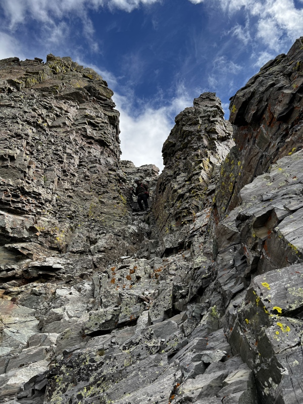
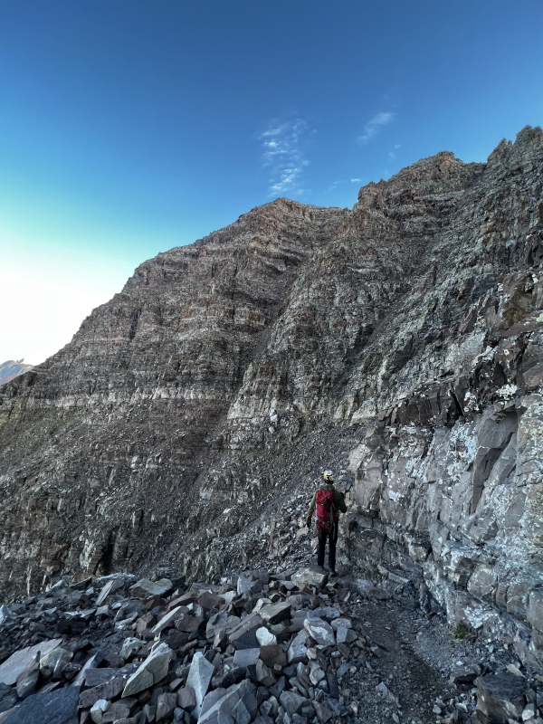
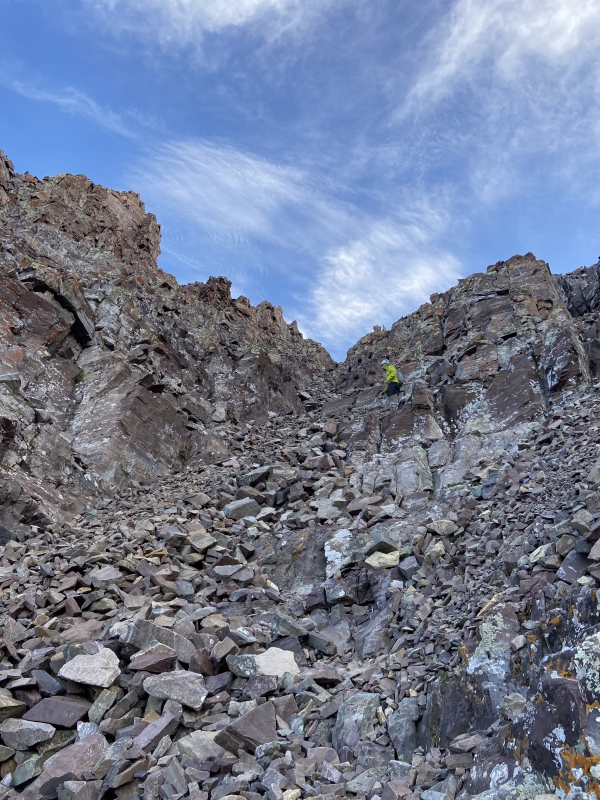
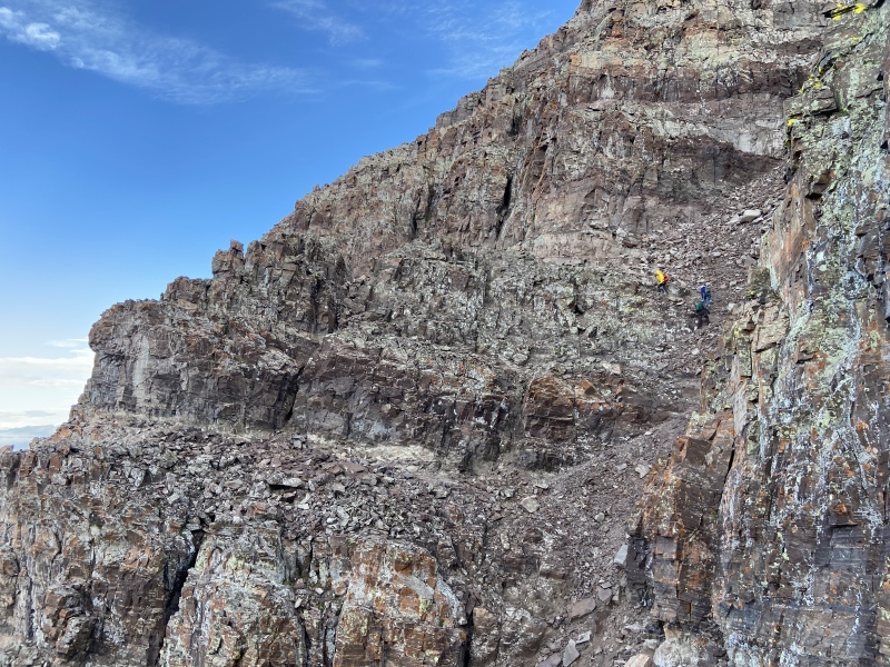
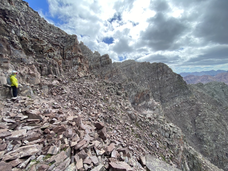
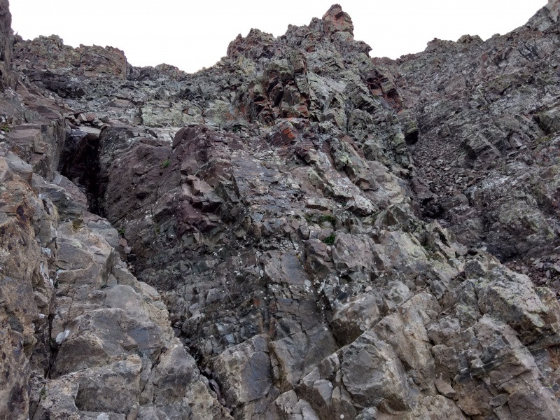
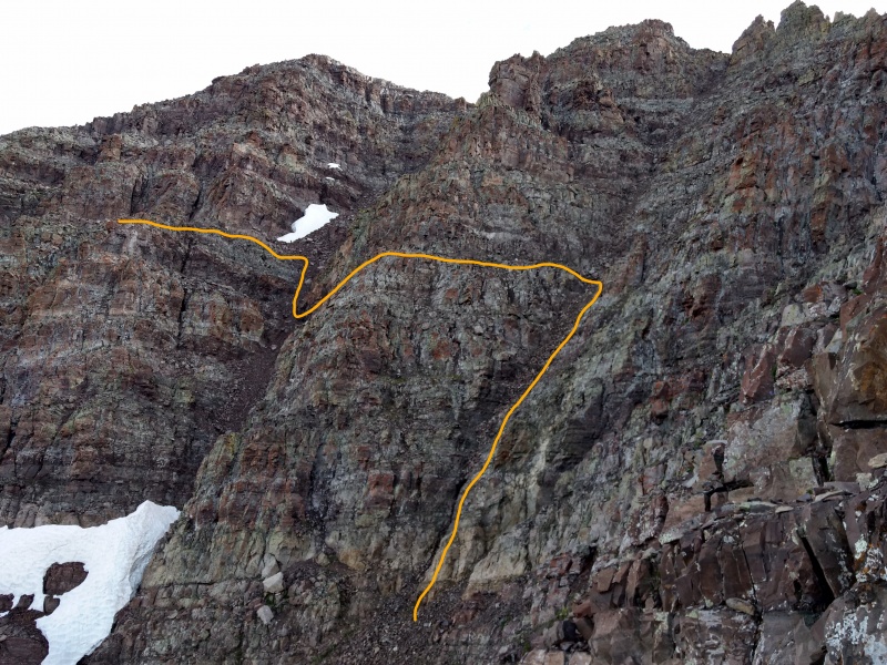
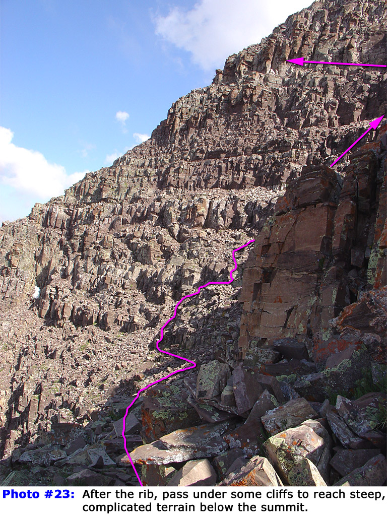
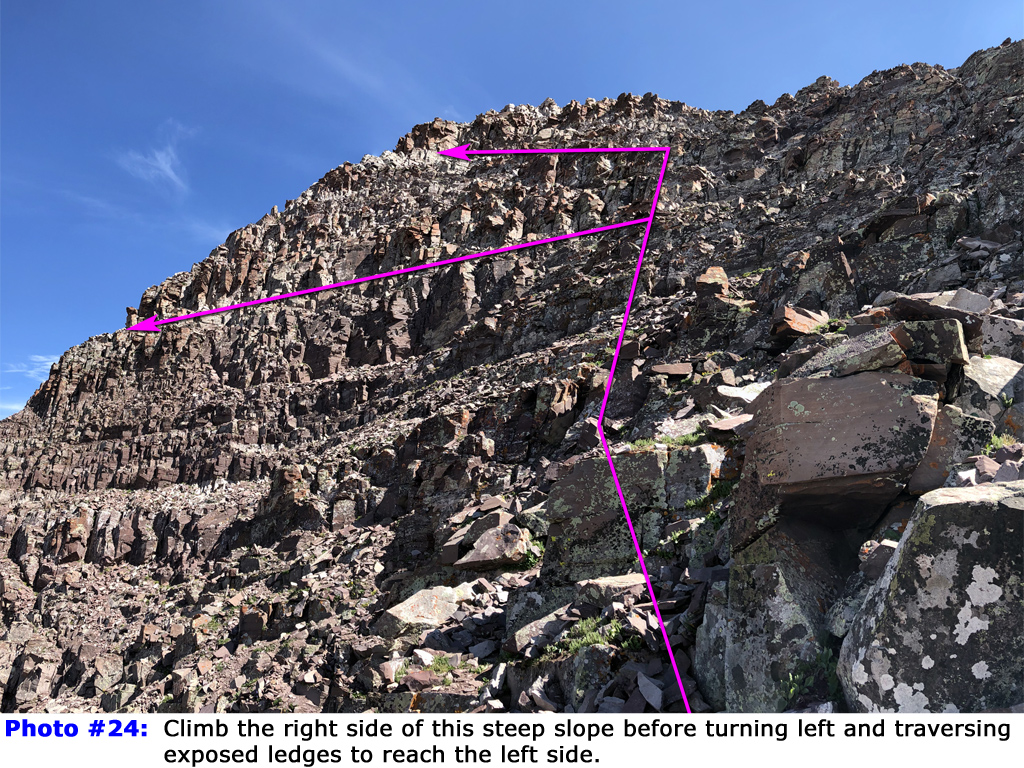
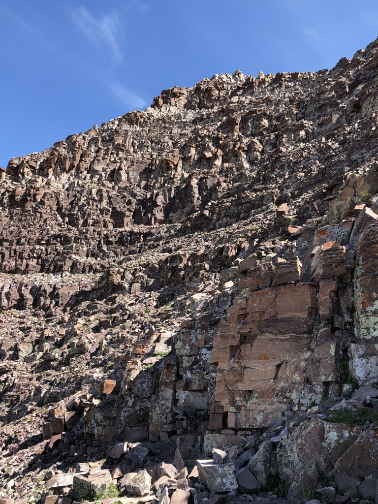
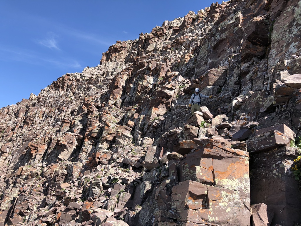
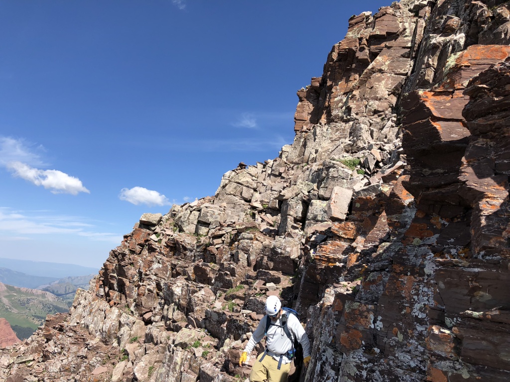
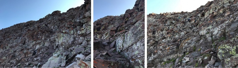
THE BROAD GULLEY & BROKEN FACES We reached the top of Gulley #2 about an hour after leaving the top of the Green Monster. There were excellent cairns indicating the Gulley #2 exit as well as along the crumbling rock ledge that led to the awesome Robot Rock. It was amazing how huge and delicate this rock formation was in-person. Who knows how many similar features, perhaps far more impressive, existed on this mountain going back thousands and thousands of years. It's only a matter of time until Robot Rock is swallowed by geological forces and becomes just another random slew of rock within the rubble pile that is Maroon Peak. (Can you tell I'm fascinated by this stuff?) After traversing around Robot Rock and the subsequent bulges on the west face of the peak, the route descends a bit to the entrance of the Broad Gulley. This gulley is much wider and longer than the previous two gullies but is also less steep. My buddy opted to stick to the climber's right of the gulley where the rock is more solid whereas I put on my microspikes and ascended straight up the middle. Even with spikes, I found the center area to be incredibly loose with large rocks that had a tendency to move if I even breathed on them. I'm not sure if my approach was any more advantageous than my partner's, but we arrived at the top of the Broad Gulley in short order at around 0800 MT, 4.5 hours after leaving Crater Lake and almost 90 minutes from the top of the Green Monster. We exited the Broad Gulley to the climber's left before a notch in the ridge line. This stretch involved working around and up a wall of sorts and there are a handful of Class 3 moves in this section with some exposure. JQDivide shows a good angle of the Broad Gulley exit pitch in Photo #19 of his helpful TR. After ascending and traversing a few more corners, following cairns, we came into view of the next major section which aligns with Photo #23 and Photo #24 from the Route Description. This is where the route-finding really picked up for us and climbing became much more tedious. This crumbling face of broken rock is very steep with a number of cairns and piles of rock that look like cairns that can easily lead to sketchier terrain. From all the TRs we reviewed prior to the climb, we knew the best approach was to ascend the climber's right side of the wall before angling north towards a prominent cairn on a ledge of whitish rock high up on the face. Again, there are a number of cairns in this area as well as on the diagonal ridge line to the north, some of which seem to indicate exiting this area much lower than we did. We learned on descent that while traversing lower does work, the ledges and cliffs in the lower and middle areas of this face are much more precarious than taking a direct ascent approach on the climber's right. Photos #70, #69, #68, and #67 from the Route Description Photo Stash Tab give what I found to be best views of this area. In these images, you can see the band of white rock higher up on the face as well as a climber on the climber's right of the area (taken on descent, but the line is the same going up). You can also see the referenced cairn on the white rock ledge in Photo #67, and this cairn was visible to us from the moment we entered this area giving us a good target in our climb. After crossing over the ridge line on the north side of the initial face, we came upon yet another area of steep, broken terrain; basically a repeat of the previous crumbly wall. All of the route photos I've seen for this stretch and the prior broken face tend to blend together and the tedious nature of the scrambling and route-finding starting basically at the top of the Broad Gulley make any description difficult. Suffice it say, we continued to climb, following cairns as well as our own intuition, keeping mostly to the climber's right in this area until we finally topped out on the ridge proper and could see the summit. Route Description Photo Stash Photo #66 and Photo #17 from WildWander's TR give some good perspective of this final stretch of tricky route-finding. 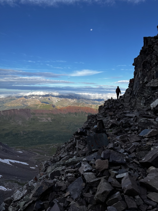
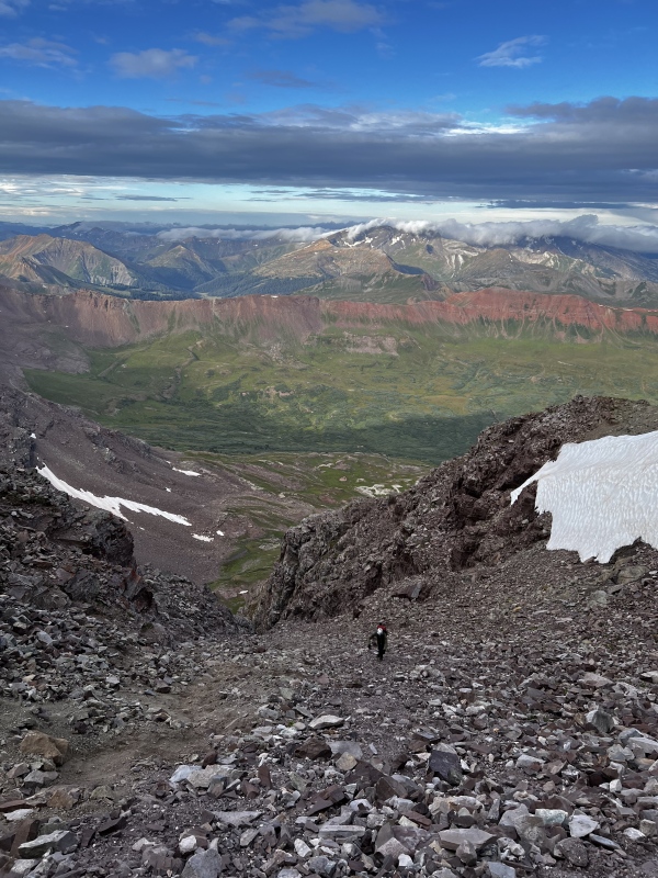
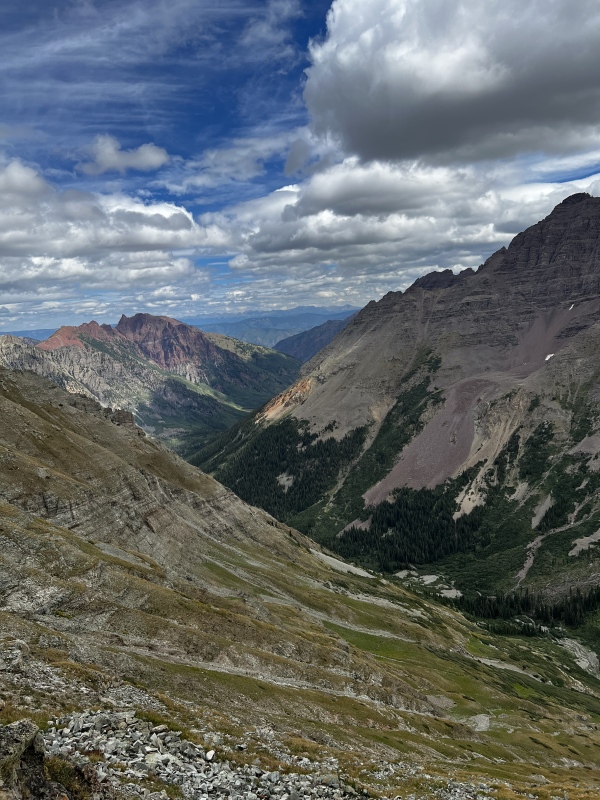
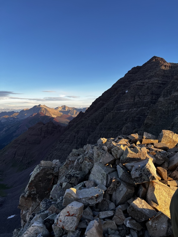
SUMMIT & DESCENT CHALLENGES After scampering up the final, talus-strewn ridge, we made the summit of Maroon Peak shortly after 0830 MT, 5 hours after leaving our campsite at Crater Lake and just shy of 2 hours from the top of the Green Monster. The views from Maroon Peak were amazing with the Maroon Creek valley and Pyramid Peak massif stretched out before us. North Maroon Peak's crumbling profile looked so close and absolutely epic from this perspective. With a clear forecast and nowhere to be, we spent over an hour on the summit. There were quite a few folks climbing Maroon Peak that day and except for us and maybe 3-4 others, everyone was doing the traverse over to North Maroon Peak. This surprised me considering how serious and technical I know that route is. A few folks even commented on our plan to descend Maroon Peak the "normal" way since it's definitely shorter mileage-wise to do the traverse. We had never planned on doing the traverse, had no research or information on the route with us, and most importantly, I had told my wife I wasn't doing it. But I would be lying if I said it wasn't tempting watching all the other climbers start down and across towards North Maroon Peak. We knew the traverse was likely within our abilities and also knew it would be a beast to descend Maroon Peak, especially with round #2 with the Green Monster waiting for us. This sense of FOMO probably made us linger on the summit an extra 15 minutes or so before slowly gathering our gear and heading in the opposite direction from everyone else. We immediately ran into issues. While on the mountain, immediately after, and even now writing this weeks later, I have no idea what we did wrong. But after we started descending from the summit we found ourselves in completely unfamiliar terrain attempting some "sketchier-than-we-remembered" moves. My best guess for what happened is that we left the summit ridge too early and/or lost elevation too quickly. We fortunately knew our general heading and did find some cairns that ensured we didn't get too far off route. But it wasn't until we turned a cairned corner on a ridge that I finally recognized our location as the first broken rock face (see description above or as shown in Photo #23 and Photo #24 from the Route Description). We realized we had entered this area much lower than where we had exited it on our ascent. We knew the preferable route was all the way across the face on the climber's right so we picked our way across some serious cliffy terrain on loose rock until we finally got to some more solid sections that began to look familiar. From here, we were able to more or less follow our ascent path the short distance down to the top of the Broad Gulley. I elected to try microspikes again in the Broad Gulley and slipped my way down the sandy, talus-filled center. My buddy followed his ascent line on the climber's right of the gulley on more solid terrain. After finding the cairned exit at the bottom, we traversed the ledges to and around Robot Rock to the top of Gulley #2. If you recall from earlier, another climber had tried to convince us that Gulley #2 was the better route than Gulley #1. Out of curiosity, I decided I would give Gulley #2 a go on descent. My buddy parted for Gulley #1 at the crossover point and I donned my microspikes again and started down. The spikes did not help at all. Gulley #2 is full of ankle deep gravel and incredibly unstable, cantaloupe-sized rocks. Factor in a very steep pitch and every move I made shot rocks down towards the bottom of the gulley. Its steepness actually increased as I descended, culminating in a large boulder obstacle that I needed to shed the microspikes to safely lower myself around. After descending this way, I have no idea why anyone would recommend Gulley #2. In addition to the absolute trash nature of the rock inside the gulley, when I finally made the bottom, my buddy was waiting for me and stated that descending Gulley #1 was a straight-forward breeze. That made my mind up once and for all. Forget Gulley #2; Gulley #1 is the way. We worked our way back across the broken rock to the chimneys and, ensuring we didn't drop rocks on each other, quickly descended them. We reached the top of the Green Monster at 1130 MT, almost two hours after we left the summit. We shed some layers, ate a snack, and continued down. While I'm not sure how much my microspikes helped in the previous gulley stretches, they were an absolute godsend for descending the "2,800 ft of suck." We did have to be careful in a few spots, and I actually biffed pretty hard trying to descend a steep rock pitch when my spikes caused me to slip. But overall, I think this is the best type of terrain to use microspikes on: steep, trailed sections with loose but shallow rock. We reached the bottom of the Green Monster two hours after leaving the top and then slowly marched back to our Campsite #4 at Crater Lake. We collapsed in our tent at 1420MT, making our total climb time just shy of 11 hours. 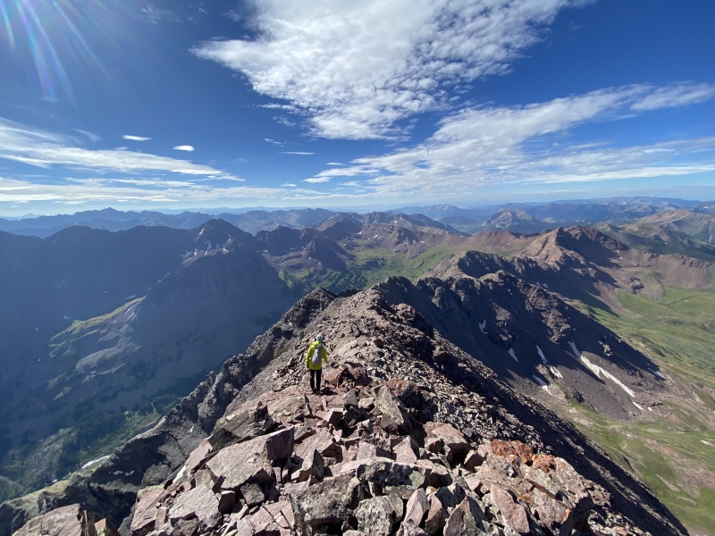

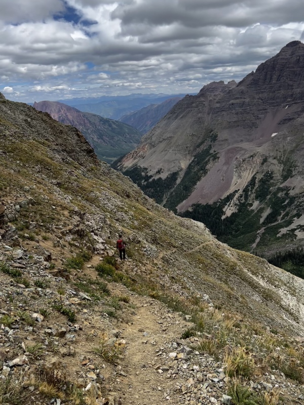
MAROON PEAK CONCLUDING THOUGHTS Maroon Peak was a beast to summit; one of the more challenging mountains I've climbed. While it lacks the epic pucker factor of Capitol Peak or the signature technical stretches of North Maroon Peak or Pyramid Peak , it more than makes up for it in length, elevation gain, and route-finding tediousness. This peak truly tested our fitness, both physically and mentally. Add in the fact we did this as part of a 3-day consecutive climbing trip, and we were thoroughly exhausted when we returned to our tent. But Maroon Peak is also incredibly special: a geologically unique peak whose crumbly western rock face demands respect. And the view from the prominent summit of Pyramid Peak, North Maroon Peak, and the northern Elk Range is breath-taking. Like no other mountain, Maroon Peak made us earn it. DAY III: NORTH MAROON PEAK North Maroon Peak TR (3 September 2023) CONCLUSION I hope this TR provides encouragement to prospective climbers about climbing Pyramid Peak and the Maroon Bells. Indeed, all three of these mountains represent serious climbing endeavors. But my climbing partner and I were never surprised nor came across anything that stretched our abilities or comfort-levels. In fact, more than any technical element or route-finding puzzle, I would venture to say the most challenging aspect of these climbs for us was the fitness requirement. These are hard mountains. The routes absolutely kicked our butts and provided multiple moments of doubt throughout each respective climb. And we are better for it. I also hope my focus on pre-climb logistics within this TR contributes positively to the discourse surrounding the regulations in place to access the Maroon Bells Wilderness areas. Yes, these rules are inconvenient and turn climbing trips like ours into multiple month planning efforts with no guarantee for success. But long gone are the days of arriving at a Colorado 14er TH in solitude; that is a fact that we all need to recognize. And these truly special areas like Maroon Lake have more and more visitors every year, for better or for worse, and need to be protected. I believe that is the spirit of these regulations. I hope by detailing at length our experience overcoming the associated inconvenience, climbers find encouragement that with a little more work, a successful trip like ours is very doable. As my partner and I trudged back down the trail from Crater Lake to Maroon Lake after our North Maroon Peak summit bid on 3 September 2023, with our gear haphazardly lashed to our packs and our energy banks running close to depletion, I couldn't help but marvel at what we had accomplished the past three days. When I started dreaming and planning this trip in the early part of 2023, I had little confidence that everything would work out as perfectly as it did. Balancing the complicated parking and access logistics, fitness regimens, and waiting for weather reports along with last minute beta consumption all made for a few stressful months leading to our climb. To have it all come together into a spectacular and successful weekend left me feeling lightheaded as we navigated through the Labor Day weekend crowds to the Maroon Lake TH. Upon arriving back at our vehicle in the overnight lot, after close to 72 hours with minimal if any weather issues, a storm system moved in and finally unloaded on the valley. I tend to believe mostly in coincidence, but as we stood there getting drenched trying to load our gear as quickly as possible for our drive home, I couldn't help but feel that the rain shower was a sign from these majestic peaks, these geological wonders, these Titans, of a job well done. 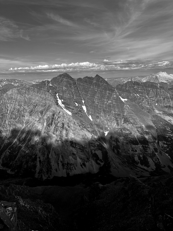
REFERENCE INFORMATION CLIMBING SPLITS: Day 1 - Pyramid Peak (1 September 2023)
Day 2 - Maroon Peak (2 September 2023)
Day 3 - North Maroon Peak (3 September 2023)
REFERENCED/USEFUL LINKS: Logistics:
Pyramid Peak:
Maroon Peak:
North Maroon Peak:
CLIMBING RESUME:
OTHER 14ER TRIP REPORTS:
Thumbnails for uploaded photos (click to open slideshow): ")
")
")
")
")
")
")
")
")
")
")
")
")
")
")
")
")
")
")
")
")
|
| Comments or Questions |
|---|
|
|
Caution: The information contained in this report may not be accurate and should not be the only resource used in preparation for your climb. Failure to have the necessary experience, physical conditioning, supplies or equipment can result in injury or death. 14ers.com and the author(s) of this report provide no warranties, either express or implied, that the information provided is accurate or reliable. By using the information provided, you agree to indemnify and hold harmless 14ers.com and the report author(s) with respect to any claims and demands against them, including any attorney fees and expenses. Please read the 14ers.com Safety and Disclaimer pages for more information.
Please respect private property: 14ers.com supports the rights of private landowners to determine how and by whom their land will be used. In Colorado, it is your responsibility to determine if land is private and to obtain the appropriate permission before entering the property.

