| Report Type | Full |
| Peak(s) |
Pyramid Peak - 14,029 feet |
| Date Posted | 11/19/2023 |
| Modified | 10/27/2024 |
| Date Climbed | 09/01/2023 |
| Author | The_Ramp |
| Additional Members | Checkers_hello |
| 3 Days in the Valley of Titans: Pyramid Peak |
|---|
|
DISCLAIMER: This Trip Report is one of three associated with our experience climbing Pyramid Peak, Maroon Peak, and North Maroon Peak over three consecutive days in September 2023. This TR focuses specifically on our climb of Pyramid Peak, though some information, including the introduction/conclusion, parking and camping logistics, and closing reference material are shared across all three TRs. I have also embedded links for the complimentary TRs within this report for easy cross reference. For background as to why I've started documenting my 14er expeditions, see my 2022 Capitol Peak Trip Report. Thank you for reading. 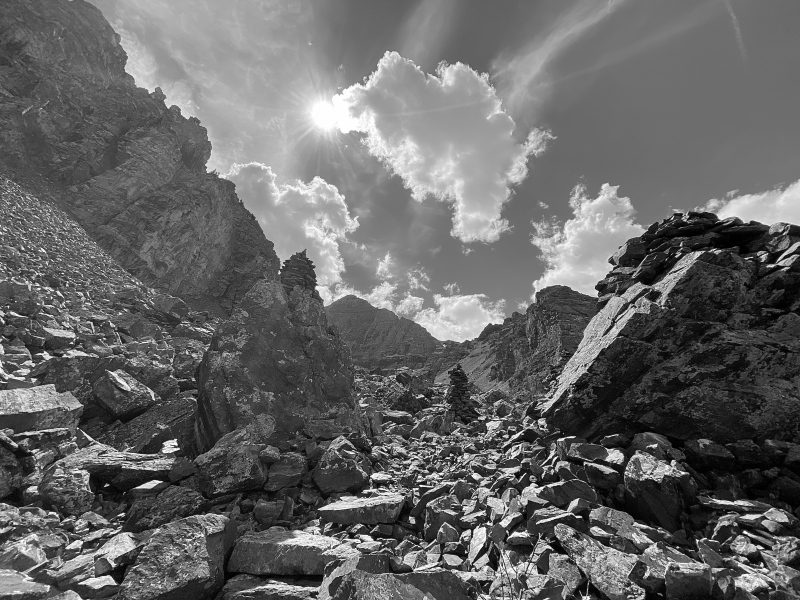
INTRODUCTION My buddy and I successfully climbed Pyramid Peak, Maroon Peak, and North Maroon Peak over three consecutive days from 1 September to 3 September 2023. We climbed via the Standard Routes from the Maroon Lake TH (Pyramid Peak) or from our campsite at Crater Lake (Maroon Peak and North Maroon Peak). Furthermore, we did NOT do the Maroon Bell traverse but elected to ascend/descend both peaks individually. This was a huge weekend involving nearly 35 miles of hiking and over 12,000 vertical feet of climbing. We were blessed with amazing weather, supportive family, and friendly fellow climbers that made this trip truly special. Each of these mountains represents a VERY serious climbing effort. All require excellent fitness, significant route-finding skills, and comfort on incredibly loose and exposed rock. Combining them into a single weekend compounded these factors and placed further emphasis on our pre-trip preparation. In addition to our experience base and fitness regimens, my partner and I studied countless 14er.com user Trip Reports for all three peaks, attempting to consume every trail nuance, route-finding tip, and climber lesson learned. More than a tricky set of moves or intense exposure, nothing disrupts my comfortability like being surprised on a climb. Please utilize those that have gone before; this website is an absolute treasure in helping prepare climbers for a successful day on these peaks. I've linked what I found to be the most helpful Pyramid Peak, Maroon Peak, and North Maroon Peak user TRs and photos throughout my report below. This includes a number of photos from the "Photo Stash" tab on the respective peak Route Description pages, a welcome aspect for these mountains considering some of the other 14er web pages don't have any photos in their "Stashes.” I included all the raw links along with some other useful information at the end of the report. But before even stepping foot on the trails for each of these amazing peaks, we had to overcome the daunting logistics associated with accessing this area of Colorado. For better or for worse, driving to the Maroon Lake TH and camping in the Maroon Bells Wilderness are both heavily regulated. Therefore, in addition to documenting our experience climbing, I delve into exhaustive detail managing all these logistics. It’s a lot. It’s too much. To skip ahead to the climbing portions of this TR, just scroll down to the first photo below. Reach out with questions. Thank you for reading. LOGISTICS To maximize our experience climbing Pyramid Peak and the Maroon Bells, our baseline plan was to park our car at the Maroon Lake TH and then pack in and camp at one of the Crater Lake designated campsites. This would allow us to have great access to the 14er climbing routes as well as provide a “home base” in between difficult summit bids without unnecessary hiking and/or driving each day. This approach, however, required significant logistical planning months in advance. Our plan required two separate, pre-purchased reservations:
Please note: everything below is based on my experience in 2023. All are subject to change year over year. Also, I do have some...reservations (pun intended) about our approach for managing these logistics which I expand on a little later in this section. MAROON LAKE TH PARKING PARKING PASS RESERVATION SYSTEM Visitors to the Maroon Bells Scenic Area cannot simply drive to the Maroon Lake TH and park; there are very strict access regulations in place during the summer and autumn months. From mid-May through October, no personal vehicles are allowed access up the road between 0800 and 1700 MT. All visitors during this time are required to take a shuttle which requires a pre-paid reservation (bikers, e-bikers, and pedestrians are excepted). The road is open outside of that time window, but in order to park a personal vehicle at the TH, a pre-purchased parking pass is required. There are multiple parking pass types, including day/evening parking, 24-hour parking, and the most coveted: a 60-hour parking pass. Parking passes cost $10, regardless of type (unless you have an “America the Beautiful Pass” or a “Maroon Bells Annual Pass,” in which case the parking fee is waived). All Maroon Bells Scenic Area shuttle and parking reservations are made via the Aspen Chamber Resort Association (ACRA) Maroon Bells Reservations web page. The ACRA Maroon Lake TH parking system has a rolling reservation release meaning parking/shuttle reservations for set blocks of dates are made available starting on a specific date and time months in advance. For example, for parking/shuttle reservations in the months of July and August 2023, the website reservation window opened on 1 April 2023 at 1000 MT. With the goal to knock out both Maroon Bells and Pyramid Peak in a single trip, the 60-hour parking pass was the obvious choice for us. But because my climbing partner and I both have busy lives including families with young children and variable work commitments, not to mention wanting to ensure a good weather opportunity, there was no way for us to predict the exact dates that would work for us months in advance when the parking reservations opened. That left us playing the game of selecting multiple date opportunities, all centered around weekends in August and September 2023, and then making several different parking reservations when the respective rolling reservation windows opened. I have a few notable observations about the ACRA website and booking parking reservations. On both reservation release dates that we used, the web page started accepting reservations 5-10 minutes earlier than the advertised 1000 MT opening time. I was lucky enough to be actively monitoring and able to take advantage of this early release. But no doubt some unlucky users would have opened the website at exactly 1000 MT to find their desired parking dates were already booked. Once I selected the desired dates, the ACRA website was very efficient in progressing through my information and payment, though I did do a “practice run” beforehand on some available dates earlier in the summer and was therefore familiar with the interface. Because of this, I was able to knock out a handful of parking reservations in a matter of minutes. Furthermore, I did NOT receive a confirmation email or notification after I booked the reservation! The only indication that I was successful was a confirmation web page that had a “Printer Friendly” link. I left these confirmation pages open on new browser tabs until I had completed booking everything I wanted, then printed all the confirmation pages to PDFs and saved them to my computer. This is important because as far as I could tell, there was no way to access my reservations via the website after I made them. Either I missed something (maybe the email got stuck in my “Junk” folder?) or this is a serious deficiency in the ACRA website/booking system. All 60-hour Maroon Lake TH parking passes for summer weekends were booked within 5 minutes of the respective reservation windows opening. All 60-hour Maroon Lake TH parking passes for the entire months of July, August, and September were booked within 24 hours of the respective reservation windows opening. There were a handful of day reservations (both 12-hour and 24-hour), mostly for weekdays, lingering for a few weeks. In total, my partner and I made seven different 60-hour Maroon Lake TH parking reservations for various weekends in August and September 2023. Of course, we did not use all of these reservations. When our plans came together later in the summer, I offered most of my unused reservations to other users on 14ers.com. This is an easy transfer to do since each parking pass has a unique number (versus being tied to an individual's name or vehicle). I say “most” because in error I had printed the wrong reservation confirmation page on two of them (remember: I received no email confirmation and without an email, there was no way for me to access my previously made reservations). So, a couple of our reservations went unused… which sucks. Again, I believe there is a serious deficiency in the ACRA website in this regard; I would have happily cancelled or found a home for these passes but had no way of accessing them again. Hopefully whoever was up there those weekends noticed a single car less of people in the area. In the end, as our dates for our climbing trip aligned, we were left with a 60-hour reservation starting 0600 MT on 2 September 2023 until 1800 MT on 4 September 2023. I also scored a 60-hour reservation starting at 0600 MT on 31 August 2023 from a fellow 14ers.com member that helped us start our weekend a day earlier which was extremely helpful to our personal commitments (and happened to make for a much better weather window as well). Thank you to user "brousseau" - this community rocks! MAROON LAKE PARKING EXPERIENCE With our Maroon Lake TH parking passes in hand, we arrived in Aspen via Independence Pass around 1900 MT on Thursday, 31 August 2023, and, after a quick pit stop for a half hour in the Aspen Rec Center parking lot to get our gear organized, we ventured further up the Maroon Creek road. We by-passed the cones surrounding the unmanned welcome station and after ogling the gigantic profiles of Pyramid Peak and the Bells from the road in the dark, we pulled into the Overnight Lot at the Maroon Lake TH without issue. We taped both parking permits to the windshield (we had two separate 60-hour passes - see above) and quietly retreated to our sleeping bags for a restless few hours of sleep. I believe sleeping in a vehicle in the Maroon Lake TH Overnight Lot is technically not allowed and have read stories of Rangers tapping on windows of vehicles during the night. But no one bothered us. We also heard some other, less-quiet parties attempting to do the same thing while bedding down. Following our successful Pyramid Peak summit bid the subsequent day (Friday, 1 September 2023), we returned to our vehicle to get our backcountry gear. We had no issues with accessing the vehicle again and we did not see any authority inspecting parking pass permits for the hour or so we were at the car. I also noticed a few cars in the Overnight Lot that did NOT have a parking pass on their dashboards. Those same cars were there upon our return two days later with no obvious violation as far as I could tell. I know for folks with half-day or full day parking permits, displaying the permits on their vehicle dashboard is not required, but those cars are supposed to park in the adjacent Day Use Lot versus the Overnight Lot. All to say, for the few cumulative hours we were in the Maroon Lake TH parking lots across our trip, I saw no one policing permits nor any sort of obvious consequence for vehicles not displaying a parking pass. As far as I can tell, I’m not sure what is stopping someone without any permit from accessing and parking at the TH in either lot, assuming they arrive outside the restricted hours. The only other observation I have is that both the Day Use and Overnight Lots were very full when we exited Sunday. I suppose it wouldn’t take much if both lots are over-prescribed for a Ranger to ascertain that someone is there who shouldn’t be. CRATER LAKE OVERNIGHT PERMIT OVERNIGHT PERMIT RESERVATION SYSTEM New for 2023 is a required overnight permit associated with various backcountry areas in the Maroon Bells-Snowmass wilderness, including the 11 designated campsites surrounding Crater Lake. Reservations for “Maroon Bells-Snowmass Wilderness Overnight Permits” can be made at Recreation.gov, which I have used frequently in the past to secure other Colorado campsites. On the permit web page includes useful information and maps, including this one which shows all the Maroon Bells-Snowmass permitted zones as well as this one which outlines the specific Crater Lake campsites. Similar to the Maroon Lake TH parking pass, the overnight permits were released on a rolling basis. For our targeted weekends in August and September 2023, the reservation system opened on 15 June 2023 at 0800 MT. There are some additional restrictions associated with these permits worth noting:
As was the case when we booked our Maroon Lake TH parking passes, at the time when the Crater Lake campsite permits became available, we did not know our exact climbing dates and were attempting to maximize our flexibility. Our plan was to reserve the maximum allowable number of reservations each (two) for four separate weekend dates in August and September 2023. So on the morning of 15 June 2023, the day the overnight permit reservations opened for August and September 2023, my buddy and I were situated in front of our respective laptops and ready with the F5 key as if we were buying concert tickets. As advertised, the dates became available for reserving at 0800 MT sharp. The Recreation.gov reservation system is a little confusing, including some intense selection and scrolling to find the right permit zone, desired campsite, and dates. And there are a lot of seemingly unnecessary inputs (livestock Y/N, entry/exits points, alternate permit holders, etc.) to complete the reservation, but having done a practice run, we were both familiar with the necessary information and made quick work of booking everything successfully. All Crater Lake overnight permits for weekends in August and September 2023 were booked within 30 minutes of the reservation window opening. Contrary to the ACRA webpage for Maroon Lake TH parking permits, we received reservation confirmation emails following our successful bid for sites. Additionally, I could log into my Recreation.gov account at any time and access my permits. Once our climbing dates solidified, we both cancelled our unused permit reservations. It is difficult to "unofficially" transfer the reservations to someone else (such as a fellow 14ers.com user) like you can with the parking passes because it clearly states on the overnight permit reservation that the personal identification of the individual occupying the campsite needs to match the name on the permit. And you can't change or add permit holders without cancelling and re-booking the reservation. One additional comment on the Crater Lake Overnight Permit reservation system: in the confirmation email there is a link to “print a parking pass" for the Maroon Lake TH. This is NOT a free or included Maroon Lake TH parking pass but instead just a link to the ACRA webpage for the specific dates of the overnight permit, which in our case were all completely sold out since the parking reservation system opened 6 weeks previously. So don’t depend on the overnight permit to provide you a Maroon Lake TH parking pass – you will need to book those separately and earlier than the camping permit. CRATER LAKE CAMPING EXPERIENCE My buddy and I were a little concerned that when we arrived at our designated Crater Lake campsite on the first day of our permit reservation (1 September 2023), we would find someone occupying the site. But after summiting Pyramid Peak and meandering our way up from the main West Maroon Pass trail at Crater Lake, we found our reserved Campsite #4 completely empty and ready for us to move in. For this trip, I elected to bring my bulky 4-man tent versus a smaller 2-man backpacking tent knowing it was a short trip from the Maroon Lake TH and to give us some more room to spread out. I actually carried the tent that morning to the Pyramid Trail turn-off before stashing it in the trees, then retrieved it after our summit bid when we went to scope out the site. Campsite #4 is large and if it’s any indication of the other Crater Lake sites, one could easily fit a larger tent or multiple small tents at these sites. All of the Crater Lake campsites are set back from the West Maroon Pass trail a bit (see map) and we continued our running joke from last year’s Capitol Lake campsite experience that the hardest part of our day, regardless of how many miles we hiked or vertical feet we climbed, was the seemingly endless slog up to the campsite from the main trail. We attached a tape-wrapped copy of our permit to the outside of the tent and left it there for the duration our stay. As for water, we filtered at the Minnehaha Gulch stream a few hundred yards further along the West Maroon Pass trail (southwest) from Crater Lake (between Campsites #3-5 and #6-8) which is super accessible and preferable to attempting to filter the silt-filled Crater Lake water. But this of course required additional soul-crushing trips up and down the Campsite #4 access trail. During our entire 2.5 day stay at Crater Lake Campsite #4, we never saw a Ranger or anyone policing the campsites, though I suppose they could have been making rounds while we were climbing during the morning/early afternoon hours. In fact, the adjacent campsites to ours were mostly empty. However, on our second day (Saturday, 2 September 2023), a group of guys set up in Campsite #5 in the late afternoon. By the way they were scoping everything out and purposefully avoiding interaction with us, we could tell something was fishy. Furthermore, there was a rather loud argument between two of them resulting in one of the guys shouting to his companions “I’m going home! Thanks for nothing!” before storming off. It was awkward. To add to the drama, a few hours after they had set up their tents, another backpacker wandered in claiming to be the “true owner” of Campsite #5 for that night. There was some discourse, but they apparently made it work and just shared the site for the night. I only bring this up because while we were relieved when no one was situated in our reserved Campsite #4 when we arrived, it clearly does happen and could result in a complicated situation. And with no observed Rangers policing the sites, I’m not sure what recourse there was if we had run into a stubborn squatter in our site. Upon returning from our final day of climbing, Campsite #5 was once again completely empty, so maybe they did get the boot from the local authority. My only other comment related to the Crater Lake camping situation is that a bear cannister is required for all overnight stays in the Maroon Bells-Snowmass Wilderness areas. There are signs plastered everywhere around the Maroon Lake TH reminding people of this fact. I have heard stories of Rangers checking backpacks for cannisters, but we were never approached. (We did of course have and appropriately used a bear bin) LOGISTICS – FINAL THOUGHTS I do have some conflicted feelings about our approach in managing these logistics, especially with how we hoarded multiple parking and camping reservations months in advance without knowing which ones we would actually use. But I'm not sure there's a better or more efficient way to do it with so much uncertainty and flexibility baked into our trip. Both the Maroon Lake TH parking passes and Crater Lake overnight permits were relatively inexpensive so even if I wasn't able to re-coup the cost of those investments (which was the case for a couple of the parking passes due to the lack of cancellation ability on the ACRA website), it didn't represent a significant financial loss. And it was nice to know that we had a reserved campsite waiting for us rather than hoping and praying something was available after lugging all our gear up to Crater Lake. Finally, given how insanely popular the Maroon Bells Scenic Area is and seeing the hordes of people up there on a holiday weekend, I do appreciate the rules and knowing their intent is to protect these incredibly special wilderness areas. I was a little underwhelmed by the lack of accountability observed at both the TH parking lots and the campsites, but maybe the local authorities take the same approach that big retailers take with theft: if they can deter 95% of the unwanted behavior, they'll live with the 5% that gets through. All that being said, given how much effort we exerted (and anxiety I had) in navigating these logistics, I was very pleased with how everything came together and worked out. In summary, to ensure success in managing the logistics associated with accessing the Maroon Bells Scenic Area, I recommend climbers:
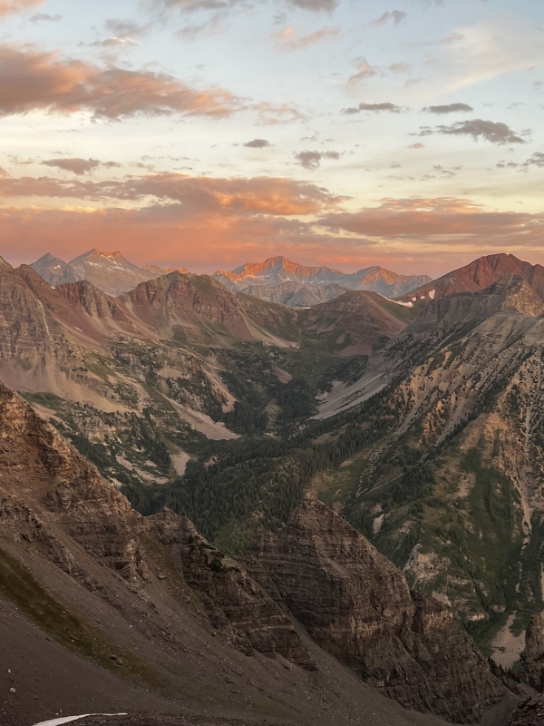
Ok, enough of all that; onto the fun stuff. DAY I: PYRAMID PEAK APPROACH, THE AMPITHEATHER, AND THE 1,000 FT SLOPE Our alarms went off at 0300 MT on Friday, 1 September 2023 but neither of us were sleeping. After gearing up (is there anything better than when a heavy bag first hits the shoulders in the early morning?) and taking advantage of the Maroon Lake TH restroom, my buddy and I were on our way up the Maroon Lake/Crater Lake Trail. We made quick work of this initial section, even while carrying the additional load of our tent, and reached the Pyramid Peak turn-off in short order. There are actually two turn-offs for Pyramid Peak and both are well-cairned and easy to find in the dark. The best way to describe them is once you reach a flatter, more open area of the Crater Lake Trail with lots of rocks, keep your eyes peeled for the cairns on the climber's left. If you hit the signed junction for Buckskin Pass/Maroon Snowmass Trail, you've gone too far. After stashing our tent in the trees, we started the switchbacks up to the Amphitheater. A big shout out to the CFI team for the work on this section of the route. We entered the Pyramid Peak Amphitheater just shy of 90 minutes after leaving the Maroon Lake TH. This area is incredibly epic, even in the dark. We did our best to keep moving and not think about the dramatic monolith that is the north face of Pyramid Peak looming over us, knowing how much more elevation we had to gain even though the summit is technically not that far away. The trail peters out after the large entry cairns but it was pretty obvious to pick our heading. There was a small snow field in the middle of the basin so we stayed on the climber's right through this initial area. Eventually, towards the top of the first major rise, there is a faint trail that we picked up that kept us above the really unstable rock near the snow field. There is some great information about navigating this area in kiwiliam's TR, including this picture which shows how to identify the trail in the mid-to-upper section of the Amphitheater. But we found it to be fairly obvious and it wasn't long before we topped a rise and were able to see our next objective to the east: the 1,000 ft slope to the saddle. We picked a path of least resistance across a short snow field and the remaining, undulating talus fields in the Amphitheater, knowing that we needed to bear slightly climber's left to ensure we picked up the trail to ascend the slope. I had read some TRs, including this excellent one from daway8, that indicate potential confusion and danger of starting this climb in the dark, but we had no problems finding the trail. It was almost 0600 MT at this time and the alpenglow was just starting to hit the valley and neighboring peaks. Having this as our backdrop helped but make no mistake, this slope is a steep, loose, and exhausting butt-kicker of a climb. As discussed in many TRs, including daway8's and this one from WildWanderer, a "hack" for these super steep and loose sections is to wear microspikes. And while I find they definitely help mitigate slippage, I always envision they'll turn a tough ascent into an easy stroll. They don't; climbs like this still suck. We finally topped out at ~0645 MT, shed the spikes, had a snack, and took in the amazing view of the eastern face of Pyramid Peak and our remaining route. 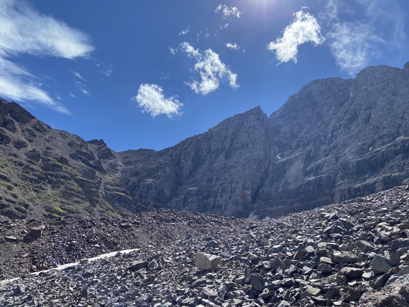
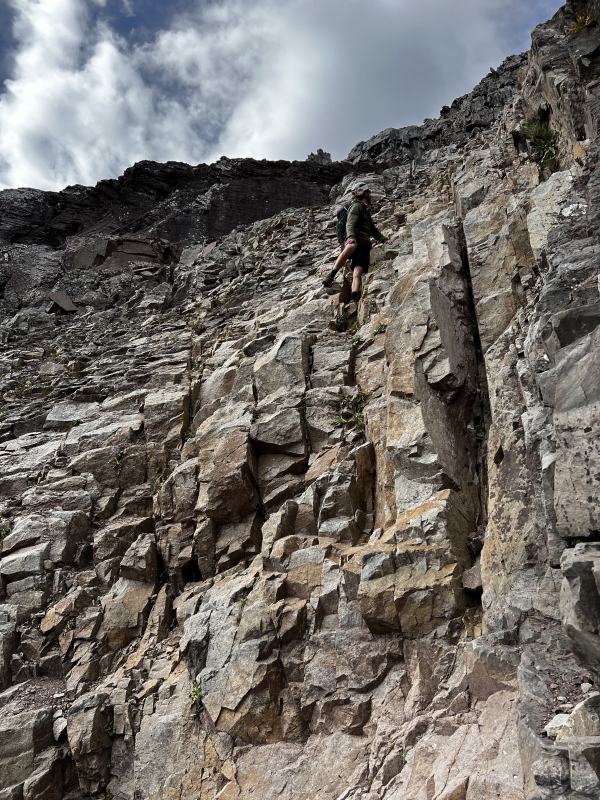
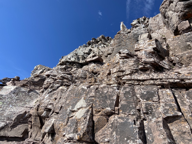
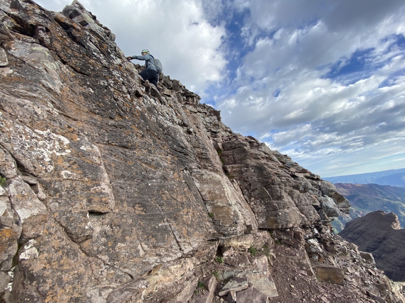
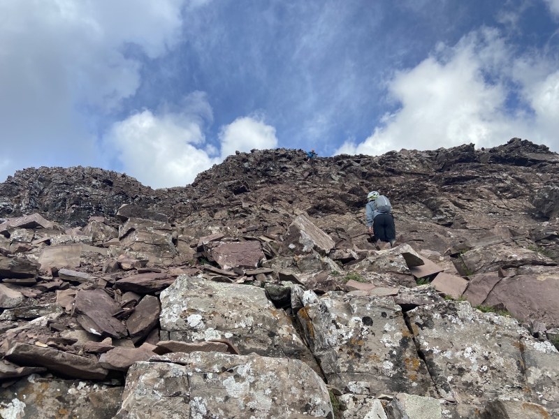
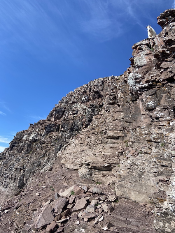
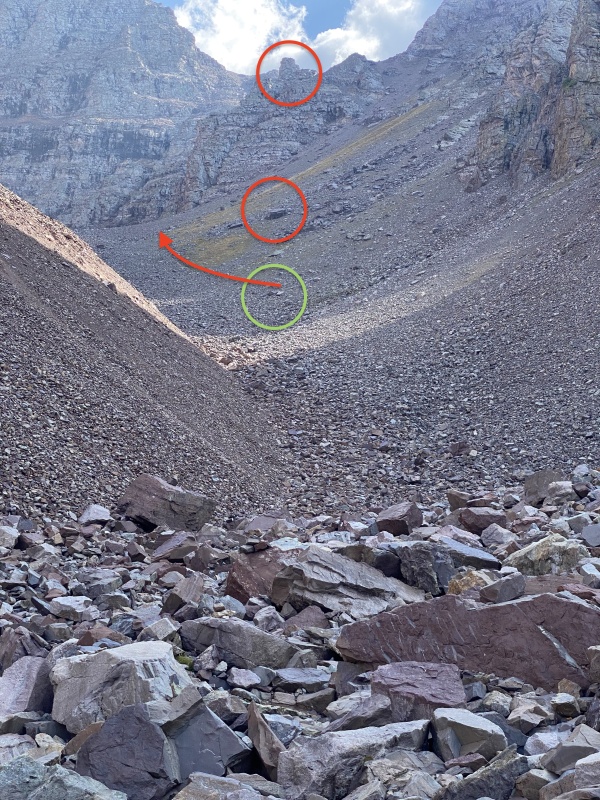
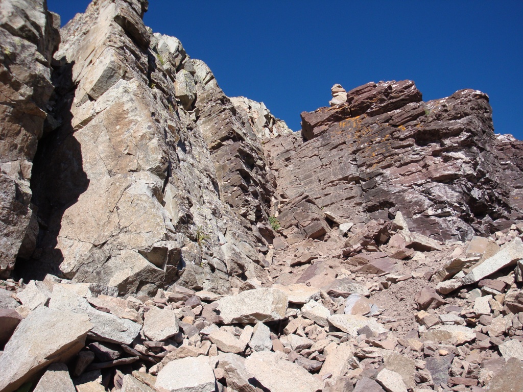
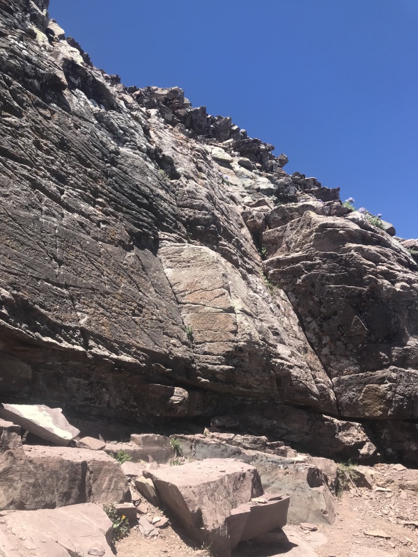
GOATS, LEDGES, & THE GREEN WALL The saddle above the 1,000 ft slope is also where we were welcomed by a member of the resident Pyramid Peak mountain goat community. From then on, we were always in sight of at least one goat, including a mother and her kid on the summit. They are funny animals, clearly used to humans and very interested in what we brought, both in our packs and in our bladders: we found the easiest way to get them to move was to urinate away from the trail as the salt in our pee was irresistible to them. The goats were a bit intimating in how close they got (their horns are super sharp!) and it was helpful to remember they are indeed wild animals. One actually followed us most of our descent but we never saw it move. Like a bad horror movie, every time we looked back it was in a new position staring at us with its dark eyes, occasionally flashing it's gray, fleshy tongue. No rocks were dropped on us though so all in all our goat interactions were a non-factor other than some amusement for the day. After we reached the top of the slope, we made quick work traversing the saddle hump on the northwest side before crossing the true low point of the ridge. From here, cairns led us up some mild Class 3 sections, mostly staying on the northwest side of the ridge. At one point, we reached a stretch where it was unclear whether to continue straight ahead up a sandy set of ledges or traverse climber's left to the southwest. This is where having the Route Description photos were very helpful - specifically this photo. We identified the rock features from the photo and followed the described path to the climber's left. Sure enough, after turning the corner, some cairns came into view that led us straight to the leap of faith and ledge system. I have read of folks following false cairns in this initial, post-saddle section and finding themselves well above the leap of faith and ledge area (documented in bbass11's TR and arianna2's TR). I'm not sure continuing higher is necessarily "wrong" per se; clearly others who went that way had success. But it does appear to involve some unnecessary elevation gain and places you in a weird spot to access the next section. As most folks have indicated, the leap of faith is less of a leap and more of a large step, but it is definitely committing over a fairly exposed gap. Once across, we traversed the obvious ledge which was over quickly without much to-do and then, after working across a gully, we were at the base of the infamous Green Wall. From the bottom, the rock looks solid and super grippy, but after starting up the first couple of moves, we realized that every horizontal surface contained a layer of fine rock debris that had fallen from above. This loose mountain "trash" was a common theme on Pyramid Peak as well as the adjacent Maroon Bells, I believe due to the fragile mudstone that makes up large portions of the upper areas and gives the peaks their reddish hue. This also gives the Green Wall and entire area a completely different perspective when viewed from above: the greenish color of the rock that is obvious on ascent is distorted and hidden by the presiding red/brown debris during descent. That being said, most of the initial moves up the green wall are Class 3 with lots of protection and straight-forward route-finding. As we worked our way up the Green Wall, I was keeping my eyes peeled for a few key features from my pre-climb research, including this Class 4-looking pitch from the bbass11's trip report (also in Photo #57 of the Pyramid Peak Route Description Photo Stash) and this boulder from JQDivide's trip report. We never found them. And before we knew it, we identified the cairns to the climber's left that led away from the Green Wall. It wasn't until upon our descent that we discovered we had blown past those mid-Green Wall sections on some solid rock on the climber's left; the point being there are multiple "right" ways through this section. 
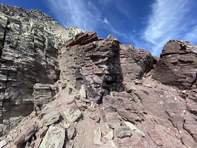
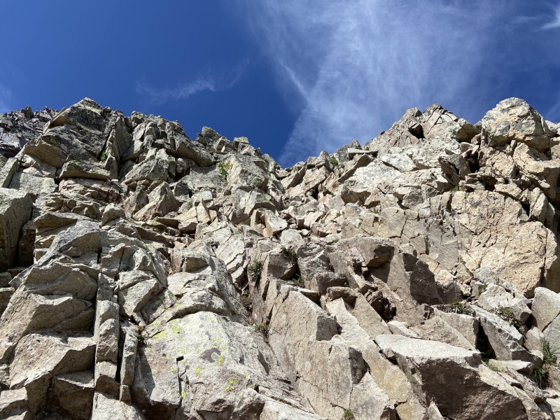
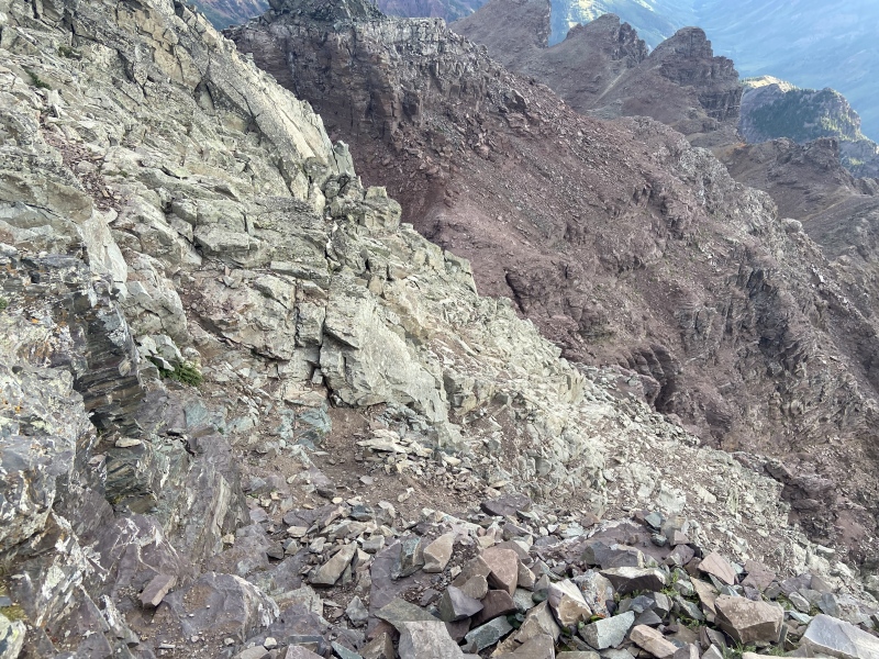
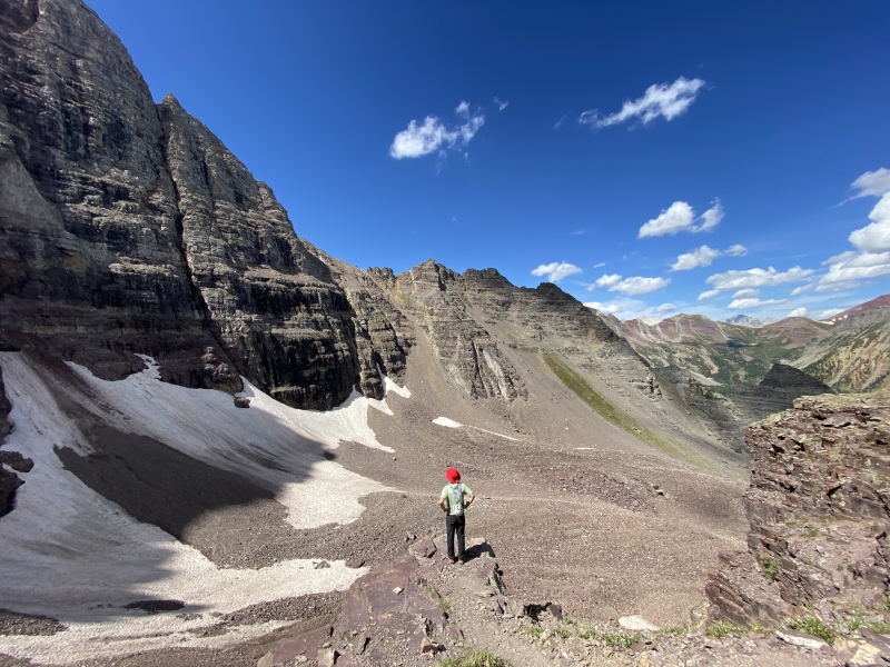
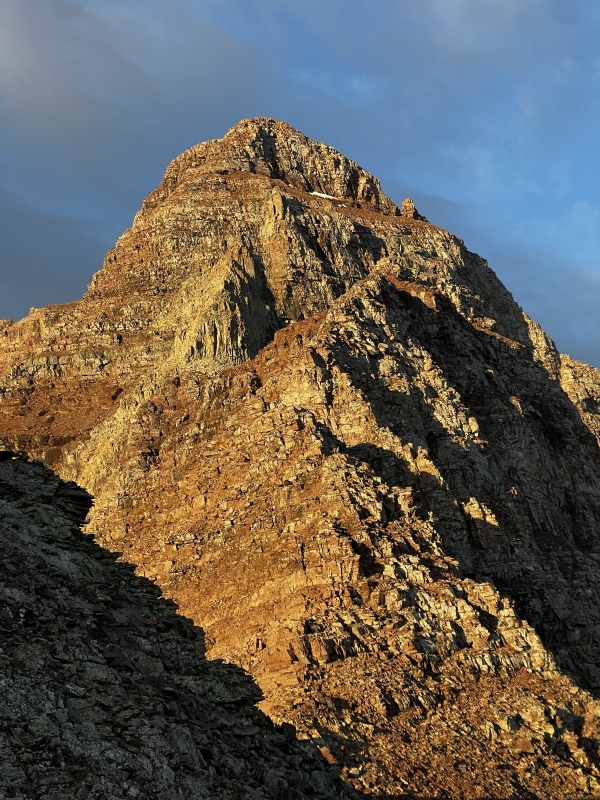
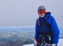
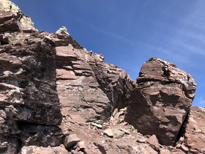
ROUTE-FINDING FUN, THE BLACK WALL, & SUMMIT After exiting the Green Wall on the northeast side of Pyramid Peak, the route-finding becomes much more challenging. The hundreds of pictures I looked at before our trip made it very difficult to identify any key features or obvious routes in this area, and it is a little disorientating in-person when looking up towards the deceiving vertical horizon (you cannot see the summit in this initial, post-Green Wall stretch). But I found this whole are to be an absolute blast. As someone who really enjoys a scrambling puzzle, I greatly appreciated assessing the situation after every move to find a path of least resistance to the next vantage point. And while there are cairns sprinkled throughout this stretch, getting from cairn to cairn made for some really enjoyable problem-solving. Additionally, while the pitch is steep, I found the exposure totally manageable with a lot of protection. This made for a much less stressful climbing experience than, for example, the southeast face of the Capitol Peak route which had a similar route-finding challenge but with the added pucker factor of intense exposure on cruddy rock. We took our time zig-zagging across the various ledges and pitches with a basic rule of thumb that if we ran into anything too sketchy or exposed, there was likely another way. Upon our descent in this area, with our good weather window and nothing to do the remainder of the day except set up camp at Crater Lake, we took even more time really trying to find the "right" way and I firmly believe you can keep this whole area at manageable Class 3 with one Class 4 exception: a short, steep pitch that I unoriginally dubbed the "Black Wall." Unlike some of the Green Wall landmarks, the Black Wall was one feature during our ascent that I correctly correlated with my pre-climb research. In PikaSteve's great TR detailing his 2020 summer of climbing in this area, he talks about running into an intimidating pitch (Photo #17) that he elected to bypass on the climber's left via some sketchier, more exposed moves. He laments upon his descent that he wished he had climbed this short pitch versus his ascent line. And I agree: after spending time below this pitch on ascent and above it on descent looking for alternative routes, scaling the Black Wall is the best way. The holds on this pitch are great, especially in the corner on the climber's right, and we had no issues climbing in either direction. And because we found we could identify it almost immediately from exiting the Green Wall, it could make a good landmark and target during the initial climbing. There was also an obvious cairn above the Black Wall so it was easy to find on our descent. After scaling the Black Wall we came into view of two "humps" on the vertical horizon. The more southernly hump (climber's left) is the Pyramid Peak summit. We followed cairns and obvious ledges that led us along the bottom of the more northerly mound's steep headwall before angling west again towards the southerly hump and the summit proper. There was one more set of Class 4 moves at the "corner" between the two humps, but everything else was straight-forward and never exceeded low Class 3. We did run into an Aspen Expeditions guide with a roped client who elected to ascend the climber's right/northerly hump directly to the summit. We chatted with them at the top and the guide said he prefers taking clients up that way as it has better views and good anchor points. They descended via our ascent line. We topped out around 0815 MT, about 90 minutes from the top of the 1,000 ft slope above the Amphitheater and almost 5 hours after leaving the Maroon Lake TH. It was a calm and beautiful summit and we took turns snapping pictures of each other on the airy diving board feature, distracting the resident goats, and taking in the scene in front and below us. The vista from Pyramid Peak is absolutely unreal and has some of the best summit views I've ever experienced. The Maroon Bells in particular are amazing as seen from Pyramid Peak. They have a totally different perspective than from the typical Maroon Lake view. And because they were hidden 99% of our climb up Pyramid Peak, their emergence on the summit was totally epic. I had seen pictures beforehand and now have some of my own, but they don't do it justice. I left them out of this report, accordingly. You'll have to discover these views for yourself. 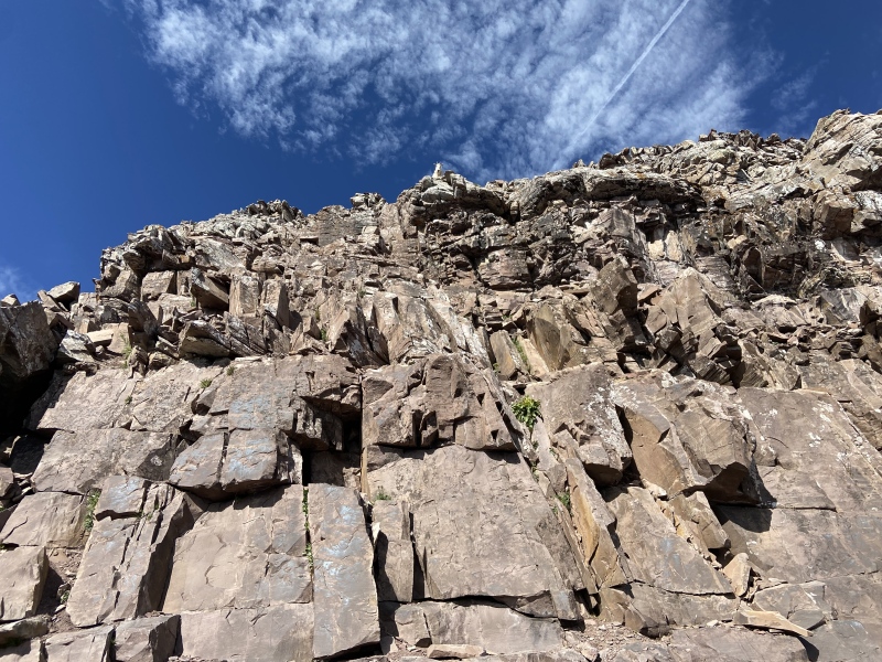
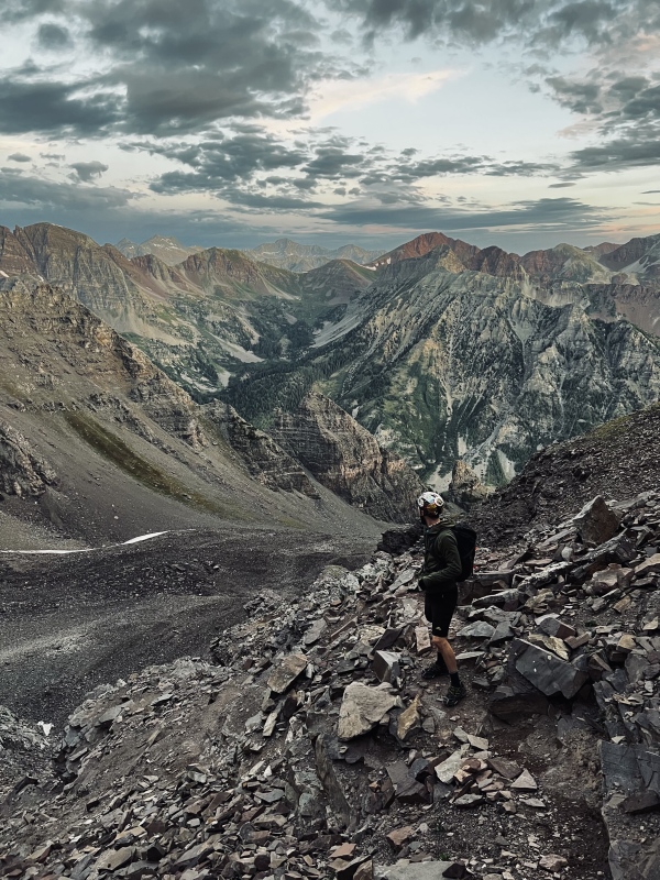
DESCENT & PYRAMID PEAK CONCLUDING THOUGHTS We lounged on the summit for over an hour and after letting other climbers get a head start to avoid rock fall, we started our descent. We really took our time down-climbing, enjoying the amazing route-finding puzzle in the upper areas of this mountain. We gave some pointers to other climbers on their way up and after bounding across the ledges, leap of faith, and saddle sections, we were back at the top of the 1,000 ft slope at 1045 MT. We put on our microspikes and started the steep grind down to the Amphitheater, which sucked just about as much as ascending. We navigated the talus in the Amphitheater, reaching the large cairns at the entrance at 1215 MT. And after descending the great switch-backing trail down into the valley, we retrieved our tent and joined the weekend crowds on the Crater Lake trail. Climbing Pyramid Peak was an absolute blast. Yes, the grind through the Amphitheater and the steep 1,000 ft slope were challenging, but they were relatively short-lived and made more interesting by the amazing setting of this mountain. And once we made the saddle, the subsequent scrambling and route-finding problem-solving up the remainder of the mountain were awesome and so much fun. Add on to that some of the most amazing summit views of any 14er, and Pyramid Peak has quickly vaulted into my shortlist of favorites. While Pyramid Peak receives much less attention than its famous neighbors, its profile is no less stunning. As we were climbing in the area over the subsequent days, we continued to marvel at the mountain's prominence over the valley, as well as our accomplishment in climbing it. DAY II: MAROON PEAK Maroon Peak TR (2 September 2023) DAY III: NORTH MAROON PEAK North Maroon Peak TR (3 September 2023) CONCLUSION I hope this TR provides encouragement to prospective climbers about climbing Pyramid Peak and the Maroon Bells. Indeed, all three of these mountains represent serious climbing endeavors. But my climbing partner and I were never surprised nor came across anything that stretched our abilities or comfort-levels. In fact, more than any technical element or route-finding puzzle, I would venture to say the most challenging aspect of these climbs for us was the fitness requirement. These are hard mountains. The routes absolutely kicked our butts and provided multiple moments of doubt throughout each respective climb. And we are better for it. I also hope my focus on pre-climb logistics within this TR contributes positively to the discourse surrounding the regulations in place to access the Maroon Bells Wilderness areas. Yes, these rules are inconvenient and turn climbing trips like ours into multiple month planning efforts with no guarantee for success. But long gone are the days of arriving at a Colorado 14er TH in solitude; that is a fact that we all need to recognize. And these truly special areas like Maroon Lake have more and more visitors every year, for better or for worse, and need to be protected. I believe that is the spirit of these regulations. I hope by detailing at length our experience overcoming the associated inconvenience, climbers find encouragement that with a little more work, a successful trip like ours is very doable. As my partner and I trudged back down the trail from Crater Lake to Maroon Lake after our North Maroon Peak summit bid on 3 September 2023, with our gear haphazardly lashed to our packs and our energy banks running close to depletion, I couldn't help but marvel at what we had accomplished the past three days. When I started dreaming and planning this trip in the early part of 2023, I had little confidence that everything would work out as perfectly as it did. Balancing the complicated parking and access logistics, fitness regimens, and waiting for weather reports along with last minute beta consumption all made for a few stressful months leading to our climb. To have it all come together into a spectacular and successful weekend left me feeling lightheaded as we navigated through the Labor Day weekend crowds to the Maroon Lake TH. Upon arriving back at our vehicle in the overnight lot, after close to 72 hours with minimal if any weather issues, a storm system moved in and finally unloaded on the valley. I tend to believe mostly in coincidence, but as we stood there getting drenched trying to load our gear as quickly as possible for our drive home, I couldn't help but feel that the rain shower was a sign from these majestic peaks, these geological wonders, these Titans, of a job well done. 
REFERENCE INFORMATION CLIMBING SPLITS: Day 1 - Pyramid Peak (1 September 2023)
Day 2 - Maroon Peak (2 September 2023)
Day 3 - North Maroon Peak (3 September 2023)
REFERENCED/USEFUL LINKS: Logistics:
Pyramid Peak:
Maroon Peak:
North Maroon Peak:
CLIMBING RESUME:
OTHER 14ER TRIP REPORTS:
Thumbnails for uploaded photos (click to open slideshow): ")
")
")
")
")
")
")
")
")
")
")
")
")
")
")
")
")
|
| Comments or Questions | ||||||
|---|---|---|---|---|---|---|
|
Caution: The information contained in this report may not be accurate and should not be the only resource used in preparation for your climb. Failure to have the necessary experience, physical conditioning, supplies or equipment can result in injury or death. 14ers.com and the author(s) of this report provide no warranties, either express or implied, that the information provided is accurate or reliable. By using the information provided, you agree to indemnify and hold harmless 14ers.com and the report author(s) with respect to any claims and demands against them, including any attorney fees and expenses. Please read the 14ers.com Safety and Disclaimer pages for more information.
Please respect private property: 14ers.com supports the rights of private landowners to determine how and by whom their land will be used. In Colorado, it is your responsibility to determine if land is private and to obtain the appropriate permission before entering the property.


