| Report Type | Full |
| Peak(s) |
Capitol Peak - 14,138 feet |
| Date Posted | 10/12/2022 |
| Modified | 10/27/2024 |
| Date Climbed | 09/03/2022 |
| Author | The_Ramp |
| Additional Members | Checkers_hello |
| Capitol Preparation |
|---|
|
DISCLAIMER: My climbing partner and I climbed Capitol Peak the same day as the tragic September 2022 fatality. I do NOT address the accident in this TR. I provided what information I could on the forum thread immediately following the incident and I won't rehash it here. I am still processing what happened that day as I'm sure are many who were on the mountain with us. And even though my buddy and I were successful in our summit bid, the memory of it will likely always carry a black cloud. The purpose of this TR is to address some of my thoughts on the climbing aspect of that September day that I think are worthwhile for folks considering Capitol Peak and to help with overall climber preparation. I have found so much incredible information on this site and from this community, but I don’t normally bother documenting my own experiences or engaging beyond taking what I need for the next adventure. After the incident on Capitol, I've been reflecting on that approach. How wonderful would it be if, by contributing just a little of our time and knowledge, more climbers could safely return from the peaks to their homes? To their friends and spouses? To their kids? And what if, by opening up about our experiences with the intent of improving overall safety associated with mountaineering, we are also in some way honoring those who can never return? I am starting to believe these notions to be true. I apologize if anything about this report is disrespectful or insensitive, especially to the loved ones of the fallen climber. Please reach out if I can help in anyway. Thanks for reading. 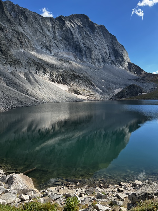
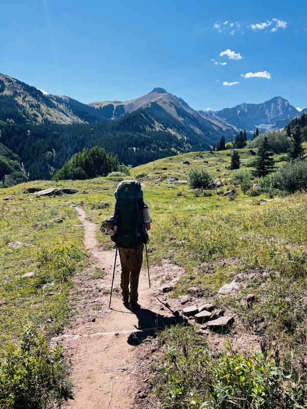
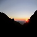
OVERVIEW: My climbing partner and I successfully summited Capitol Peak on Saturday, 3 September 2022. The purpose of this report is to provide some insight and feedback on the climb based on our experience, including a few key sections of the route that I feel don't receive enough attention. First of all, this is a VERY serious mountain - something that has been iterated over and over on this site. I encourage climbers only attempt this peak if they have significant experience on Class 4 terrain, with an emphasis less on climbing mechanics (which are very helpful, don't get me wrong) but more on route-finding and comfortability with loose and extremely exposed terrain. Ensuring a good weather window is also a no-brainer: expect to be on airy rock with no escape or obvious shelter for upwards of 8 hours. And finally, and what I attempt to emphasize most in this report: preparation, preparation, preparation! In addition to my experience base and maintaining a general fitness level, I spent hours studying the route and other TRs on this website, even printing and bringing along some of the images and descriptions I found most helpful. I strongly recommend climbers do the same. In talking with some other groups around Capitol Lake the night before our climb, I was surprised by the lack of knowledge about the route. Focus seemed to be centered on the Knife Edge, which, while epic and airy, represents <1% of the entire route and is arguably the most straight-forward bit of climbing after the Mt. Daly saddle. Please utilize those that have gone before; this website is an absolute treasure in helping prepare climbers for a successful day on Capitol. I've linked what I found to be the most helpful Capitol Peak TRs and user photos throughout my report below. I also included all the raw links along with some other useful information at the end of the report. Reach out with questions. Thanks for reading. APPROACH & THOUGHTS ON DITCH VS CREEK TRAIL My climbing partner and I left Denver early Friday morning of Labor Day weekend, 2 September 2022, and made great time to the Capitol Creek TH. The rough section of the road to the TH is short and straight-forward in a 4WD vehicle (I drive a stock Xterra) and likely doable in an AWD, high-clearance vehicle. There are some big humps that could be tricky with a longer, low-clearance vehicle. There were a handful of parking spots at the TH when we arrived which I'm sure filled quickly given how many people we saw in the basin that evening. We were hiking by 1000 MT, taking the Capitol Ditch Trail. This is a great approach trail with minimal elevation gain and amazing views of Capitol Peak starting right at the TH. This mountain is IMPRESSIVE and is looming over you the entire approach. After ~3.5 miles, the Capitol Ditch Trail merges with the Capitol Creek Trail (more on that in a sec) and then it's another 3 to 3.5 miles to Capitol Lake. We arrived at Capitol Lake around 1330 MT to find most of the campsites available, which was a pleasant surprise considering it was a Friday before a holiday weekend. After scouting a few of them, we opted for Campsite #2 which was a bit of a trek up from the lake trail but had an awesome view of Capitol Peak. I should note we had amazing weather: hardly a cloud in the sky the entire afternoon and very little wind. I suppose if the forecast called for afternoon storms, some of the other, less-exposed campsites in the trees might be better. And sure enough, the campsites were all spoken for by 1600 MT, but there is a lot of places to pitch a tent and folks were respectfully spreading out throughout the evening. May 2023 Update: Starting in 2023, back-country overnight permits are required to camp at Capitol Lake. Permits are reserved through Recreation.gov. The permits are released on a rolling schedule but must be purchased in advance. More information available on the website. Following our successful summit bid the following day (3 September 2022), we packed out via the Capitol Creek Trail for no other reason than a change of scenery. Both the Ditch and Creek trails converge at the TH and the Creek trail does involve more elevation loss than the Ditch trail, which means on our way out we had a ~400ft climb right before reaching the TH. But I think we were both happy with this variation. Don't get me wrong, hiking ~7 miles after an 8 hour day of epic climbing is a major grind. But because the Creek trail was new to us, we weren't playing the mental game of "I remember this rock; we have to be close." And the aspen groves along this trail are SO beautiful, much more so than along the Ditch trail. My buddy's Garmin also indicated the Creek trail to be about 0.25 miles shorter so take that for what it's worth. 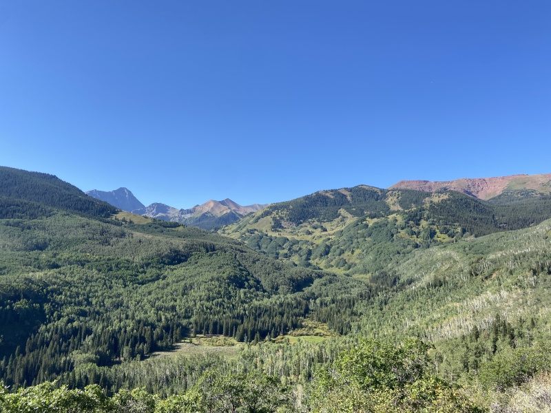
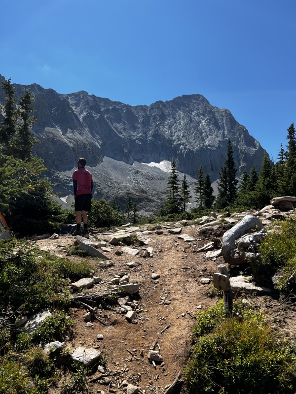
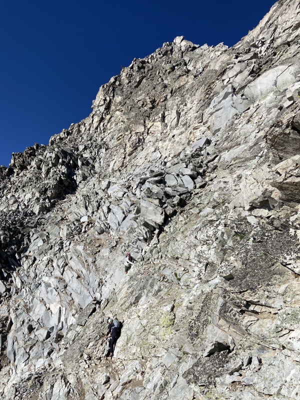
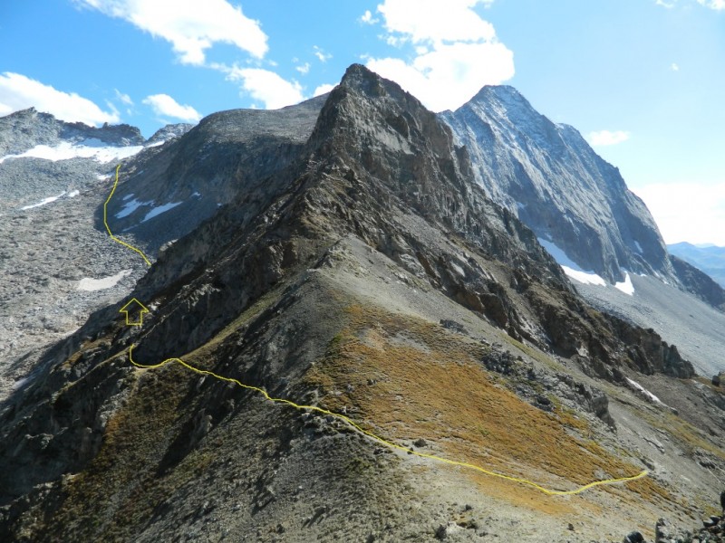
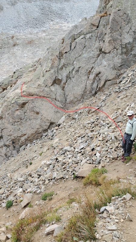
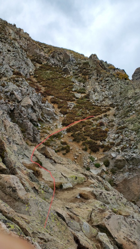
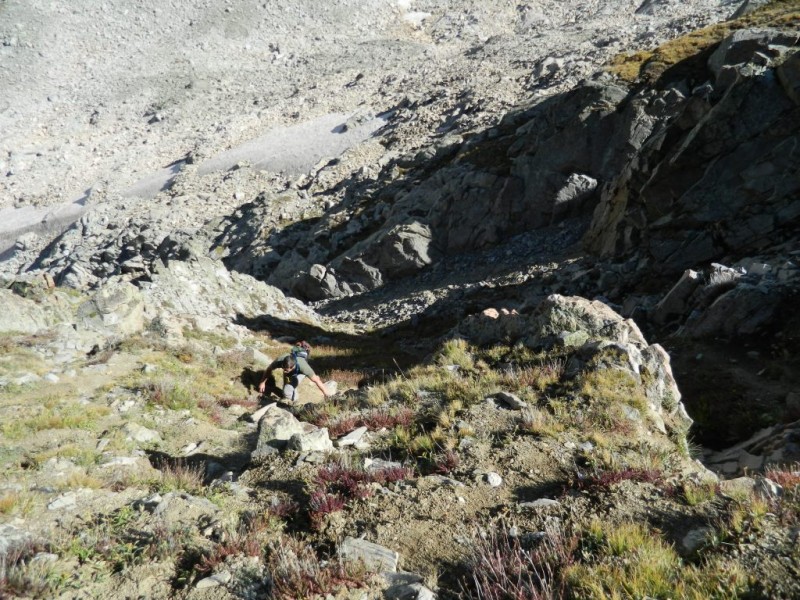
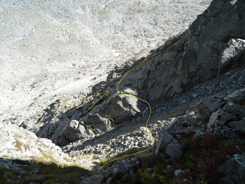
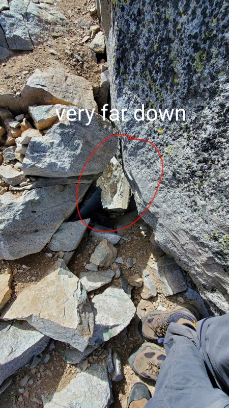
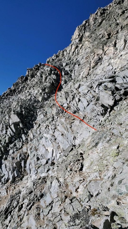
GULLIES & TALUS Our alarms were beeping at 0330 MT Saturday, 3 September 2022, and we were moving by 0400 MT, making quick work of the switchbacks to the Mt Daly saddle. According to the Capitol Peak route description on this site, the top of the saddle marks "the end of easy, trail hiking." This is a true statement. From here, the trail continues for a bit on the east side of the ridge, crossing the first of 3 gullies, which I’ll call Gully #1. PHOTO #16 of bdloftin77's excellent TR shows a great view of this initial Gully #1 traverse on a trail. After Gully #1 is where the trail seemingly disappears, or at least splits into multiple trails across the top of and down into a second gully: Gully #2. This is the first puzzle of route-finding and where pre-climb research really paid off. Based on our preparation, we elected to descend a series of steep but short switchbacks on the climber's right of Gully #2. Eventually these switchbacks disappear into the crummy, washed-out rock of the gully proper, basically at a point where Gully #3, which was unseen until this point, converges with Gully #2 into a "Y" shape. This is where I think a lot of folks make a mistake and decide to climb Gully #3, which is just trash and exhausting to even look at. Instead, we traversed the combined Gully #2/#3 to a beautiful crack in the far wall. With a few quick moves up the crack, we found ourselves back on a trail that leads you directly to the talus field beyond the gullies. The crack is obvious if you know to look for it, even in the dark. It was also relatively straight-forward to find on our descent, especially once you come into sight of the gullies (it's basically right where Gully #2 and #3 converge). And there is a trail leading to it from the talus field; just don't go too high as you cross the last bit of talus on your descent. See THIS PHOTO and THIS PHOTO from arianna2's TR and PHOTO #17 and PHOTO #18 from bdloftin77's TR for great views of the Gully #2 switchbacks and the crack in the side of Gully #2/#3 that leads to easier terrain. DeTour's TR also provides good description and photos of the gully area, though note their group elected to ascend Gully #3 which I do not recommend. I had some of these key images printed and with us during our climb. Once on the trail following the gullies, we entered the amazing talus field. There are some awesome boulders in here, some that are bigger than a minivan, and also some large boulders that will move. Talus scrambling is some of my favorite climbing so we had fun choosing our own adventure. In retrospect, we might have stayed too high initially, perhaps in an attempt to avoid too much elevation loss. But since the northwest side of the talus basin is undulating, we probably ended up ascending/descending as much elevation versus if we had stayed lower and in the "middle" of the area. There are quite a few cairns in the basin which were helpful at times, some of which seemed to point to easier terrain in the lower/middle areas, but we knew our general heading and stuck to lines that were most comfortable and enjoyable for us. It's also worth noting too that we heard a few rockfalls while in this area so staying too high against the ridge face runs the risk of being hit by a slide. After quite a bit of fun scrambling, we finally reached “the corner” of the talus basin where we turned right (west) and could observe our next target: K2. It was still dark at this point in our ascent and Jupiter was shining brightly almost directly above K2. It was awesome. We scampered up the rest of the talus to the base of K2 and then elected for the Class 3/Class 4 direct ascent of K2 versus what is shown on the site route description. We were the first group to summit K2 that morning at approximately 0630 MT, 2.5 hours after leaving camp. We were finally able to retire the headlamps as the alpenglow spread around us and had a snack while enjoying the amazing scene of Snowmass, Pierre Lakes, and the southern Elks glowing in the morning light. But dominant in our minds was the epic view of Capitol and the job in front of us. 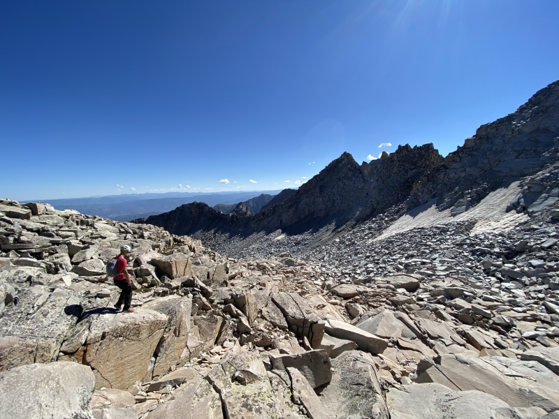
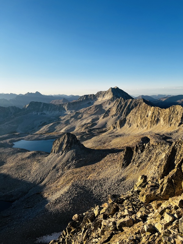
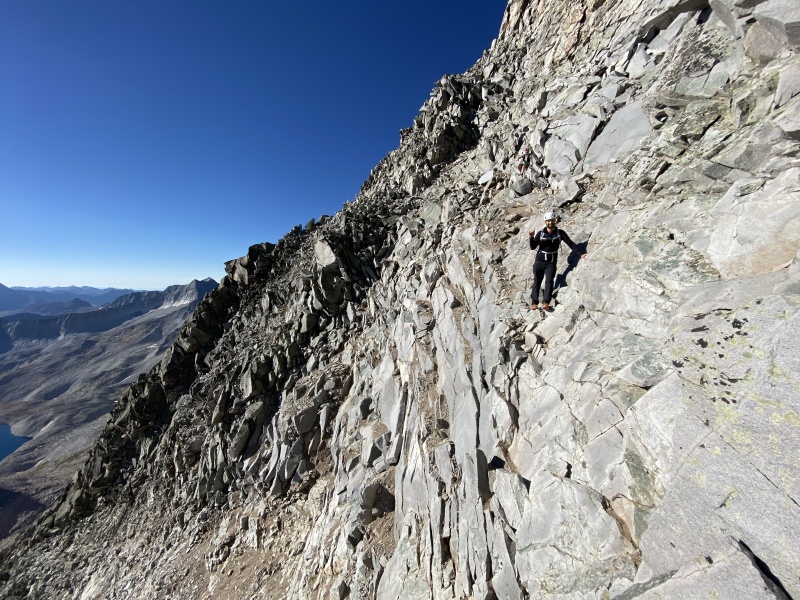
K2 DESCENT & CROSSING THE NORTHEAST RIDGE There is an amazing view of the remaining route up Capitol Peak from K2. THIS PHOTO and associated caption description from arianna2's TR gives a good overview of the major obstacles on the climb from the K2 summit vantage point, including the Northeast Ridge as well as the East Face, especially the target notch to exit the face to the final summit ridge (more on that later). We descended K2 on the north side down some steep slabs. This line involved a handful of Class 3 moves and one big Class 4 move. My climbing partner, who is a little taller than me, was able to make the Class 4 move without too much difficulty, but it took me a couple tries (and some help) to find a blind ledge for my footing. When we re-ascended K2 later in the day, the move was much easier. We also saw some folks having success following a rocky ridge a little more east/climber's left from the slabby line we took; that way could be easier if the big Class 4 move gives you pause. As emphasized in other TRs for Capitol Peak, I strongly recommend re-ascending K2 on your descent from the mountain; the bypass route looked extremely loose and exposed, and, from what I've read, is not a good alternative. PHOTO #42 of JQDivide's TR gives a good view of the slab route on the north side of K2, including the big Class 4 move. PHOTO #38 of bdloftin77's TR shows the alternative ridge route to descend (and re-ascend) K2 that we observed other climbers having success taking. After descending down and around K2, it was onto the Northeast Ridge proper. In addition to the Knife Edge, there are a lot airy slabs and towers along the ridge that require careful maneuvering and line selection. At a couple instances we felt traversing slightly below the ridge along some amazing crack lines was preferable and safer, even if the exposure was notched up a bit. Overall, this whole section of the climb was a blast! (Bonus points if you can find this epic hole from arianna2's TR at the bottom of K2. We accidentally found it when my buddy absent-mindedly leaned against the adjacent rock - yeesh!) 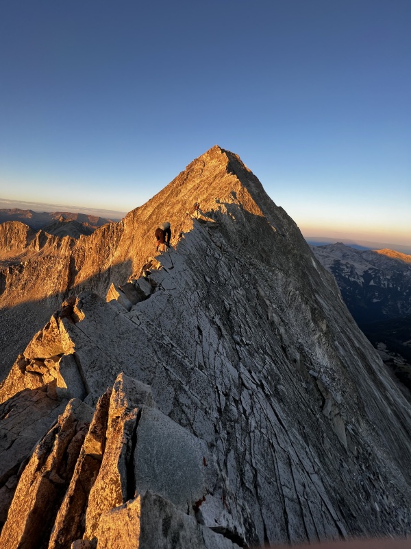
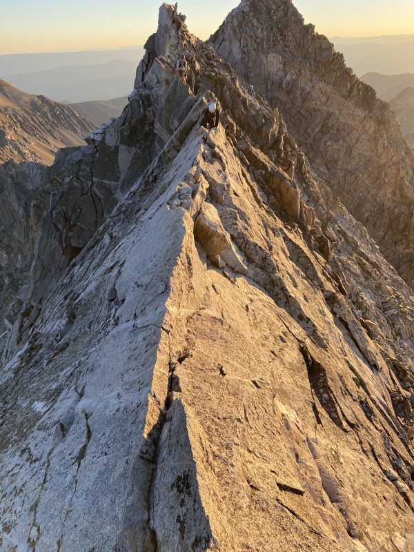
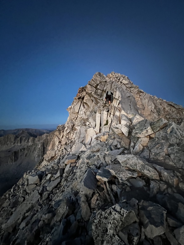
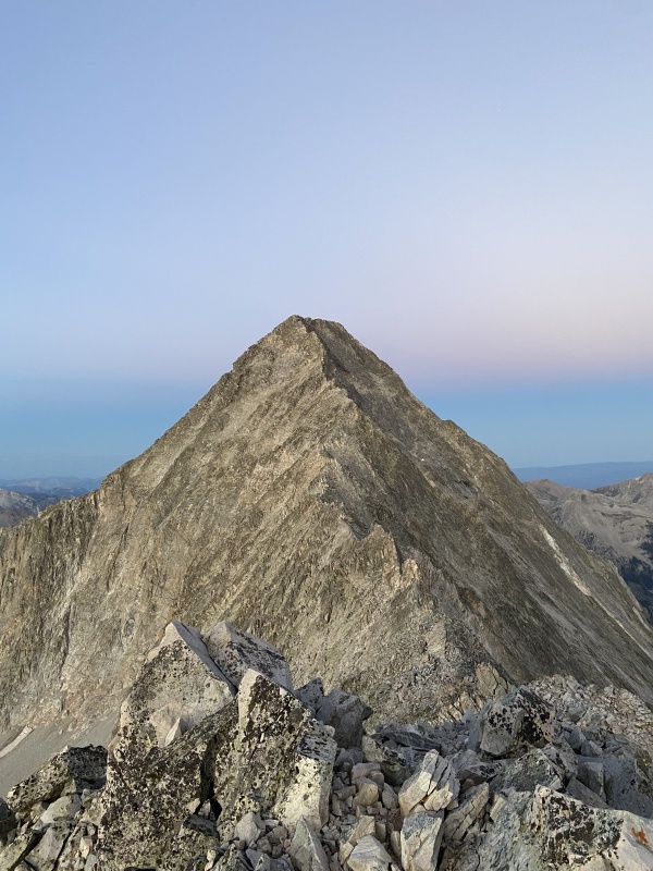
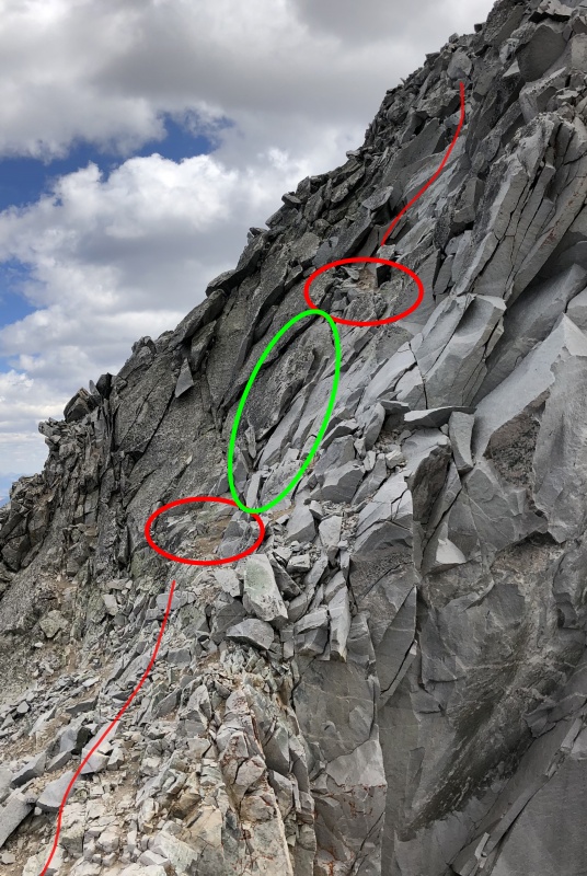
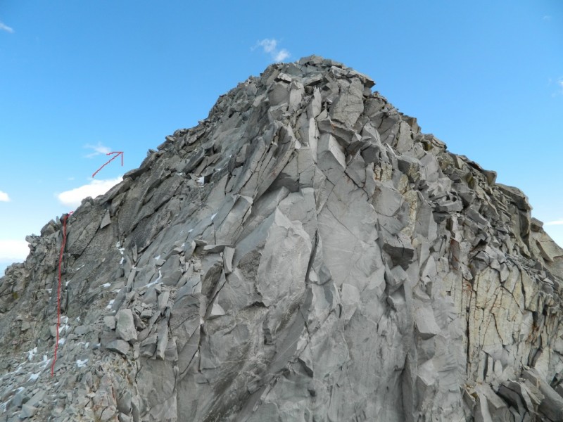
EAST FACE, SUMMIT RIDGE, & DESCENT Based on our preparation and research, the part of the climb that made me the most anxious wasn't the Northeast Ridge and Knife Edge, but the East Face and the myriad of reports and photos I had seen showing a near vertical wall of granite with tiny ledges, crumbling rock, and confusing cairns. My anxiety was not wrong: this was hands-down the most challenging section of mountain climbing I've ever done. The route-finding in this area is particularly puzzling as there appeared multiple cairns across all areas of the face, some of which led to areas lower on the face and others leading almost to the face ridge proper. Throw into that some very loose rock and slip-and-its-your-last fall risk and we had to be on our A-game the entire time. In reviewing others climber TRs, we knew the most promising route was to angle high during the initial part of the East Face because it allows for a better avenue across a final, steep gulley right before exiting the East Face. Again, there are cairns that take you lower, but we either ignored those or didn't bother looking for them, knowing that aiming high from the beginning would help with the subsequent areas on the face. SpringsDuke's TR from their successful summit bid gives an excellent overview of how to aim high initially in the area, as well as discussion on a previous failed attempt where they took a lower line. Their photos were invaluable to have printed for comparison as we worked our way along the East Face. Once we crossed the final, steep gully on some exposed, narrow dirt ledges, it was onto the crux of the route: the scramble to the notch to exit the East Face and make the summit ridge. arianna2's TR has some great photos of this area, especially THIS PHOTO, that helped keep the exit notch goal in our sights at all times. We followed her path to the notch almost exactly. Again, I felt the final set of moves past the steep gulley and to the notch were the crux of the route. Some of the rock up this steep section was extremely precarious and the whole area required focused route-finding to keep the moves at Class 4. As stated frequently, other user TR photos were very helpful to have on-hand during our ascent. Once we made it through the East Face exit notch, part of me was under the impression the summit was just a quick scramble away. I was wrong. The climbing actually amps up on the ridge, enhanced mainly by the amazing exposure. We first ascended a steep area headed northwest, basically following the ridge line to the top of the East Face summit, which is also a bit of a false summit, before traversing west until we hit the true summit. We stayed mostly on the ridge proper the entire way to the summit after the East Face exit notch, though there are a couple areas where you can actually drop lower on the Pierre Lakes (south and west) side. This entire section of rock is pretty solid and is mostly Class 3, but holy-moly is the exposure awesome: Capitol Lake felt directly below us and 2000ft away. I was reminded of the science-fiction novel “Ringworld” where the characters are struggling to maintain their mental composure amidst an unbelievably mind-blowing landscape, it was that epic of an experience. My buddy and I agreed that the final traverse on the summit ridge was the true pucker test of the peak, potentially surpassing the Knife Edge if for no other reason than it was somewhat unexpected, more sustained, and following 1.5 hours of already brain-breaking climbing. We summited Capitol Peak at approximately 0800 MT, 4 hours after leaving camp and 1.5 hours from K2. We didn't linger longer than 20 minutes and after a few celebratory fist bumps, photos, and Justin's peanut butter cups, we started our descent. The climb down the summit ridge and onto the East Face was very slow going, with ample time spent checking each hold and ensuring we didn't stray too far from our ascent line. And descending the East Face itself was an absolute challenge. The route-finding in particular was a serious puzzle. Trying to remember our ascent route and ensuring each move made sense was mentally exhausting. It took us the same amount of time to descend the summit ridge and the East Face as it did to ascend and our focus and attention never let up. 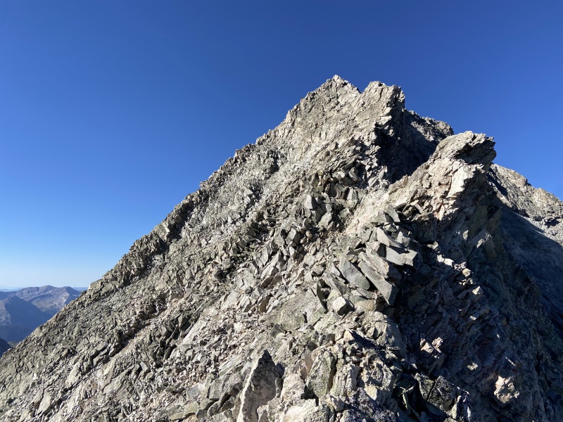
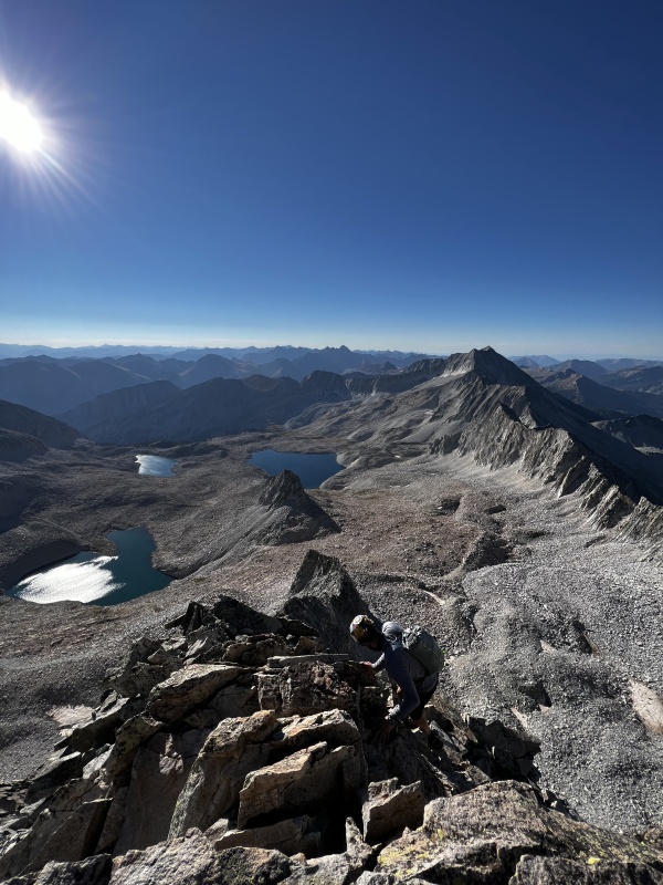
EPILOGUE & FINAL THOUGHTS After descending the East Face, we worked our way back across the Northeast Ridge, giving some climbers ahead of us ample space and time, while enjoying the views, exposure, and comparatively solid rock. We re-summited K2, sent "We're OK" texts to the wives, shed some layers, and began the talus and gully grind back to the Mt Daly saddle, arriving in view of our campsite at approximately 1200 MT, 8 hours from when we left our tent. We bombed down to the lake, broke camp, hefted our heavy packs, and started the long march back to the TH - taking the Capitol Creek variation as stated earlier in the report. After carefully driving down the humpy TH road, hitting a gas station in Carbondale for some peanut butter M&Ms and Cheetos, we motored home, making great time down I-70 back to Denver. Climbing Capitol Peak was an absolute thrill. This was far and away the most challenging peak I've done, but because of our significant preparation, including studying a lot of the amazing resources on this site, I never really felt uncomfortable or surprised throughout the entire two-day adventure. And though I was beat by the time we got back the TH, the sense of accomplishment never left. It still hasn't. Every time I look back at the photos from our successful climb, I think, "Wow - I did that?!?!" Yes, yes I did. I hope if nothing else, this report gives climbers encouragement that with the right preparation, Capitol Peak is within reach. Cheers. 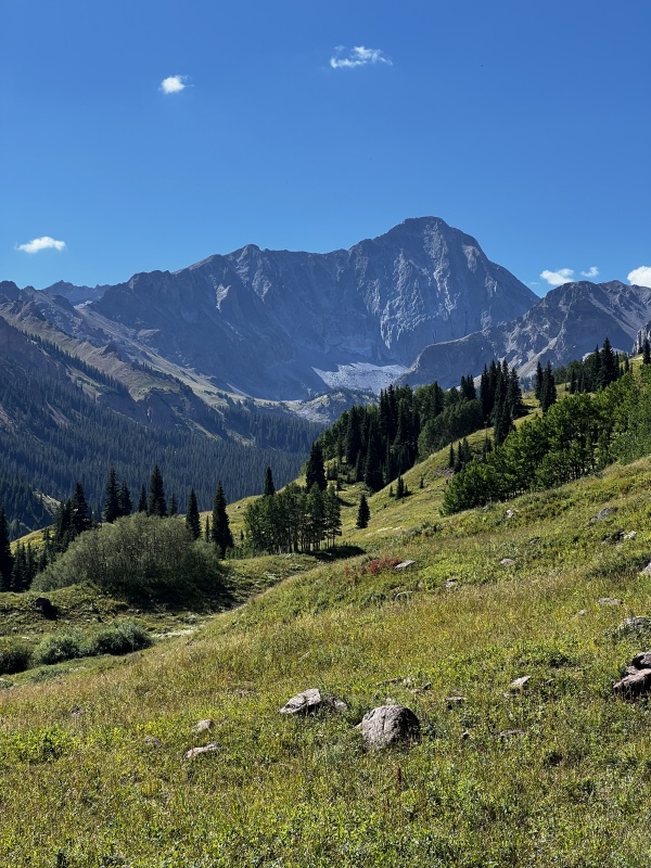
SPLITS: Friday, 2 September 2022:
Saturday, 3 September 2022:
REFERENCED TRIP REPORTS:
ADDITIONAL HELPFUL TRIP REPORTS:
CLIMBING RESUME:
OTHER 14ER TRIP REPORTS:
Thumbnails for uploaded photos (click to open slideshow): ")
")
")
")
")
")
")
")
")
")
")
")
")
")
")
|
| Comments or Questions | ||||||||||||||||||||||||
|---|---|---|---|---|---|---|---|---|---|---|---|---|---|---|---|---|---|---|---|---|---|---|---|---|
|
Caution: The information contained in this report may not be accurate and should not be the only resource used in preparation for your climb. Failure to have the necessary experience, physical conditioning, supplies or equipment can result in injury or death. 14ers.com and the author(s) of this report provide no warranties, either express or implied, that the information provided is accurate or reliable. By using the information provided, you agree to indemnify and hold harmless 14ers.com and the report author(s) with respect to any claims and demands against them, including any attorney fees and expenses. Please read the 14ers.com Safety and Disclaimer pages for more information.
Please respect private property: 14ers.com supports the rights of private landowners to determine how and by whom their land will be used. In Colorado, it is your responsibility to determine if land is private and to obtain the appropriate permission before entering the property.


