Download Agreement, Release, and Acknowledgement of Risk:
You (the person requesting this file download) fully understand mountain climbing ("Activity") involves risks and dangers of serious bodily injury, including permanent disability, paralysis, and death ("Risks") and you fully accept and assume all such risks and all responsibility for losses, costs, and damages you incur as a result of your participation in this Activity.
You acknowledge that information in the file you have chosen to download may not be accurate and may contain errors. You agree to assume all risks when using this information and agree to release and discharge 14ers.com, 14ers Inc. and the author(s) of such information (collectively, the "Released Parties").
You hereby discharge the Released Parties from all damages, actions, claims and liabilities of any nature, specifically including, but not limited to, damages, actions, claims and liabilities arising from or related to the negligence of the Released Parties. You further agree to indemnify, hold harmless and defend 14ers.com, 14ers Inc. and each of the other Released Parties from and against any loss, damage, liability and expense, including costs and attorney fees, incurred by 14ers.com, 14ers Inc. or any of the other Released Parties as a result of you using information provided on the 14ers.com or 14ers Inc. websites.
You have read this agreement, fully understand its terms and intend it to be a complete and unconditional release of all liability to the greatest extent allowed by law and agree that if any portion of this agreement is held to be invalid the balance, notwithstanding, shall continue in full force and effect.
By clicking "OK" you agree to these terms. If you DO NOT agree, click "Cancel"...
This was by far my favorite 14er I've ever climbed. It's a serious climb though. 5 hikers lost their lives climbing Capitol this past summer. My condolences to their friends and family. If you're up for Capitol, do your research and have a plan before you go.
I drove a low-clearance car and had to park a little way down from the trail-head on the road. Trucks and SUV's would have no problem.
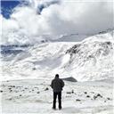
This is the view from the trail-head. It's about a 2 1/2 to 3 hour hike to the campsites at Cap Lake. I couldn't find my water filter so I packed in all the water I would need. Made it a heavy load. I would recommend packing as lightly as possible.
I read a lot about the cows being annoying. They never bothered me. Just watched me walk by.
The entire hike was beautiful. The closer I got to Capitol the more excited I was.
There are a couple creek crossings. The only one to worry about getting wet is pictured above. Take the trail to the left then cross into the grass to find a log stretched across the water. I crossed with dry feet both coming and going.
I reached the campsite at Capitol Lake after dark, set up camp, and crashed. The trail up to the K2/Daly saddle is right across from the second set of campsites (5-8), which are closer to the lake. This picture was borrowed from another trip report. It was dark when I started the hike.
First light at the top of the saddle. Amazing views already.
I chose the longer route which drops down on the other side of the saddle into the valley.
My route is in blue. There are two other routes from the saddle. One goes straight up and onto the ridge (marked in green) and another follows a narrow path just below the cliffs (marked in red). More on that later.
There were several snow fields to cross but the trail was easy to follow until that last turn to the right at the top.
View to the Southwest.
First view of K2. I could not find a trail or cairns to follow. Just rock-hopped all the way up.
I went straight up to the top of K2. The K2/Capitol ridge is just below but there's a steep cliff straight ahead so you have to scramble down to the right as shown in the pic above.
This was the view as I scrambled down K2 to the ridge. Capitol Lake and the upper campsites where I made camp are marked.
A flower growing from the K2 cliff walls.
Finally to the K2/Capitol ridge. The safer side of the K2/Capitol ridge is on the left. The only section of the ridge that you can't safely walk is the infamous Knife's Edge. After the K2/Capitol ridge, I followed the route (marked in blue) with less exposure just below the Capitol ridge.
The Knife's Edge. This group did the âbutt scootâ". I found the âmonkey walkâ" to work well for me. Just don't rush and don't forget to breathe. It's very stable rock.
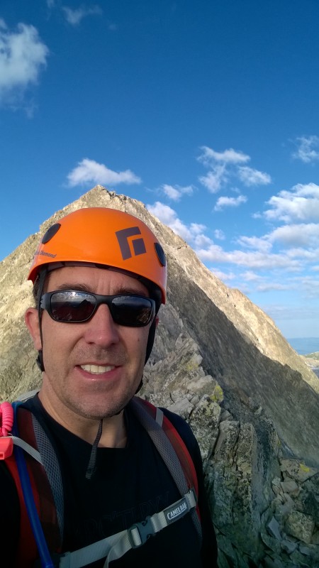
That's me.
Towards the end of the ridge crossing. You dip down and around a crevasse then it's a lot of scrambling the rest of the way. There are several trails you come across on the way up. Sometimes there is no trail to follow. Sometimes it is very loose and challenging to get good footing. I thought parts of this section were more dangerous than the K2/Capitol ridge and the Knife's Edge because of the instability of the rock.
Beautiful snow lake just below Capitol.
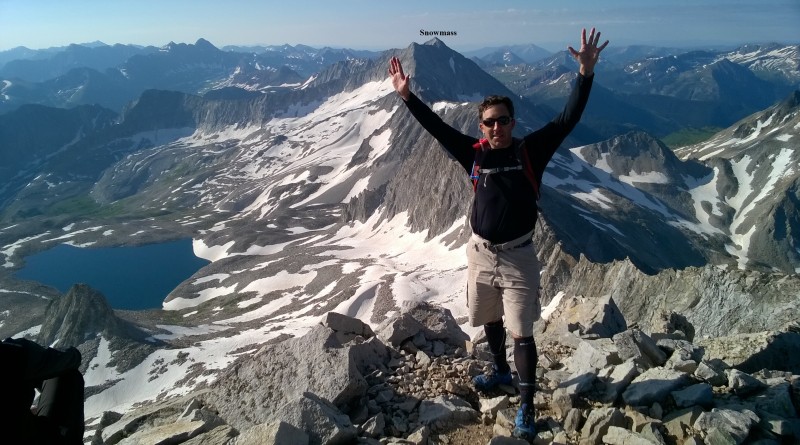
Finally to the top. Snowmass Mtn. just in the distance. Met some fun people at the top. One guy said he followed the upper ridge all the way to the top from the K2/Capitol ridge and said it was very stable. I decided to try that down.
The blue line along the ridge was my route down. It was easier than I thought it would be and mostly stable. Toward the lower section, it became very steep so I cut down and made my way toward the crevasse and then back to the K2/Capitol ridge. The route down Capitol ridge definitely had more exposre than the route I took up but I jumped two groups who started down before me so it saved time and I think it saved effort. I never felt like I was in danger until that last steep section.
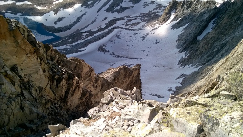
View from the lower section of the Capitol ridge on the descent.
The last view from the Capitol ridge just before I cut down to the crevasse.
Start of the K2/Capitol ridge.
Knife's Edge
On the way back, I decided to scramble across K2 rather than use the energy going up to the summit and back down. There was more exposure but it saved time and energy.
After chatting with a hiker on Capitol's summit, I decided to follow the ridge to the K2/Daly saddle rather than drop back down into the valley. I dropped down a little too soon by mistake. There was a clear path I followed which descended down to the right.
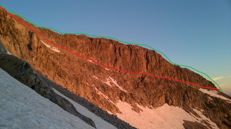
This was the path I followed. I should have stayed higher on the ridge until I could see the saddle. Just around this corner I found myself on the path just below the cliffs that several trip reports mentioned not to take.
The red line was my route. The green line was the route I was hoping to take. There was a lot of exposure. There were sections with too narrow of a path, sections with unstable surfaces, very steep sections, and snow covered sections that were a little dangerous to cross.
After crossing the saddle, on the way down to the camp.
Beautiful reflections in Capitol Lake.
Several marmots along the route.
Finally done. I wanted a nap but still had to pack up camp and hike out.
Beautiful views all the way back to the car.
A little afternoon shower rolled in and felt great but didn't last long enough.
Last look. Exhausting day!!
Thumbnails for uploaded photos (click to open slideshow):
That return below K2 had to be pretty intense. We tried going that way on the way up one time when a snow cornice blocked the K2 summit, but it seemed way too loose and exposed for me and I turned back. Glad you made it safely across! Nice report.
Caution: The information contained in this report may not be accurate and should not be the only resource used in preparation for your climb. Failure to have the necessary experience, physical conditioning, supplies or equipment can result in injury or death. 14ers.com and the author(s) of this report provide no warranties, either express or implied, that the information provided is accurate or reliable. By using the information provided, you agree to indemnify and hold harmless 14ers.com and the report author(s) with respect to any claims and demands against them, including any attorney fees and expenses. Please read the 14ers.com Safety and Disclaimer pages for more information.
Please respect private property: 14ers.com supports the rights of private landowners to determine how and by whom their land will be used. In Colorado, it is your responsibility to determine if land is private and to obtain the appropriate permission before entering the property.


")
")
")
")
")
")
")
")
")
")
")
")
")
")
")
")
")
")
")
")
")
")
")
")
")
")
")
")
")
")
")
")
")
")
")
")
")
")
")
")
")
")