Download Agreement, Release, and Acknowledgement of Risk:
You (the person requesting this file download) fully understand mountain climbing ("Activity") involves risks and dangers of serious bodily injury, including permanent disability, paralysis, and death ("Risks") and you fully accept and assume all such risks and all responsibility for losses, costs, and damages you incur as a result of your participation in this Activity.
You acknowledge that information in the file you have chosen to download may not be accurate and may contain errors. You agree to assume all risks when using this information and agree to release and discharge 14ers.com, 14ers Inc. and the author(s) of such information (collectively, the "Released Parties").
You hereby discharge the Released Parties from all damages, actions, claims and liabilities of any nature, specifically including, but not limited to, damages, actions, claims and liabilities arising from or related to the negligence of the Released Parties. You further agree to indemnify, hold harmless and defend 14ers.com, 14ers Inc. and each of the other Released Parties from and against any loss, damage, liability and expense, including costs and attorney fees, incurred by 14ers.com, 14ers Inc. or any of the other Released Parties as a result of you using information provided on the 14ers.com or 14ers Inc. websites.
You have read this agreement, fully understand its terms and intend it to be a complete and unconditional release of all liability to the greatest extent allowed by law and agree that if any portion of this agreement is held to be invalid the balance, notwithstanding, shall continue in full force and effect.
By clicking "OK" you agree to these terms. If you DO NOT agree, click "Cancel"...
Long time site user but first time trip reporter here. I wanted to give some intel on the Columbia/Harvard traverse.
I hiked into Horn Fork basin Friday afternoon (8/14) and set up camp right after the H/C trail split. There were a lot of campers around but sites were plentiful. On Saturday, 8/15, I did the traverse from Columbia to Harvard using Tommyboy360's excellent trip report as a guide: https://www.14ers.com/php14ers/tripreport.php?trip=9016
After doing it in this direction, I agree with Tommyboy's recommendation to go this route versus the traditional Harvard -> Columbia route, mainly for the reasons he lays out in the report. A couple of additional takeaways:
The new trail on Columbia is excellent - kudos to the CFI and other folks who have been working on it for years. The new trail only goes up to about 13,000 ft but is a massive improvement from what I understand to be one of the worst routes up any 14er. Above the new trail, the traditional Sawatch steep and loose part starts but it was over quick and I was on the final ridge before I knew it. Because of the awesome trail, my legs felt fresh on the summit of C and ready for the difficulties ahead.
The traverse is NO JOKE - took me 3.5 hours peak to peak. There is A TON of talus and route-finding as well as steep and gnarly terrain. I am in no way a fast hiker but I felt I kept a pretty steady pace throughout. Please be smart and educate yourself on this route before taking it on.
Going to C->H lets you knock out the hardest part of the traverse (the steep descent off of C and the endless talus grind below "The Rabbit") on relatively fresh legs.
Most of the traverse is in the sun and got hot pretty quickly. I drained 4.5L of water plus a Gatorade throughout the whole day. I met a guy the day before who did H->C with 2.5L of water and ended up having to do the last pitch up C and the whole descent without water. Make sure you bring lots to drink.
The initial descent off of Columbia is steep, long, and full of talus - I can't imagine having to go UP it on very tired legs.
One downfall of going C->H is you lose some visibility of the dangers and difficulties, primarily as you enter the talus basin area below "The Rabbit." There are a lot of cairns but they are hard to see going C-> H and easy to miss.
You need to go pretty low to bypass the first unseen cliff band, lower than you might think. There is a cairn that comes into view and I remember thinking "really - that low?" Yes - really, that low.
Again, there is A LOT of talus. A LOT. From the point of by-passing the initial cliff band to the point where the "A, B, C, D" pic from Tommyboy's report is taken took me a lot longer due to having to route-find over and through the talus (which I kind of enjoy). Please avoid this route if you don't like talus hopping.
After passing below the original "white slab" ("A" in the report), make sure to go UP over the major boulder field before dropping back down towards the "flat box rock" ("C" in the report). I tried to cut through the rocks and had to make some sketchy talus moves that could be avoided if you stay high. There are also cairns that would guide you the right way, they were just hard to see going C->H.
It took me two hours from the summit of C to the low point of the traverse.
I took the "lay up" per Tommyboy's report around point 13,516 and up through the grass back to the trail. It was definitely helpful on tired legs.
The final push along the ridge to Harvard's summit is tricky. There is some route-finding and I missed a couple cairns so had to make up some of it as I went. I did a few Class 3 moves that would've been a lot of fun had my legs not been jello.
I think the final pitch up the Harvard summit block on the standard route is class 3. I saw a lot of folks (and dogs) struggling up and down.
Thankfully, I left my dog at home. Do yourself a favor and don't bring the dog on these peaks. Both Columbia and Harvard have some sketchy stuff up high that would be hard for a dog. And then the traverse is out of the question in my opinion. Hike with your 4-legged pal on Elbert or Huron instead.
I met a lot of folks on H who were considering starting towards the traverse (at 10AM which would put them on C around 1 or 2PM at the earliest). I think the look on my face and some of my intel persuaded some of them against it. Again, please be smart and do your homework before considering this route.
I think, if the weather is good and you are a fast hiker, going up and down H and then up and down C by the standard routes might actually be faster than the traverse. And certainly less tiring. Especially because the C trail is so good.
Times: - Left my tent at the H&C trail split at 4:00AM - Summit of C: 6:05 AM (left at 6:20 AM) - Low point of traverse (start of "easy" part up to H): 8:20 AM - Summit of H: 9:50 AM (left at 10:20 AM) - Back to tent: 12:15 PM - Back to TH: 2:00 PM Total time: 8 hours, 15 minutes tent to tent; 10 hours tent to TH
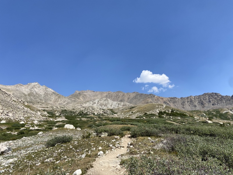
Overall, this was a hard but rewarding day. These were my final two Sawatch 14ers and I also hit 50 total 14er summits with this climb (#41 and #42 individual peaks). I was all by myself until passing some hikers going H->C about 0.25 miles from the H summit. It was a little smokey early in the morning but then the wind shifted and it cleared up; otherwise there was hardly a cloud in the sky. And Horn Fork basin is beautiful and as advertised; great views, wildflowers, and plenty of mosquitos. Definitely a highlight of going this way is this descent into the basin which made the final few miles back to my tent rewarding.
I included some pics below.
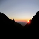
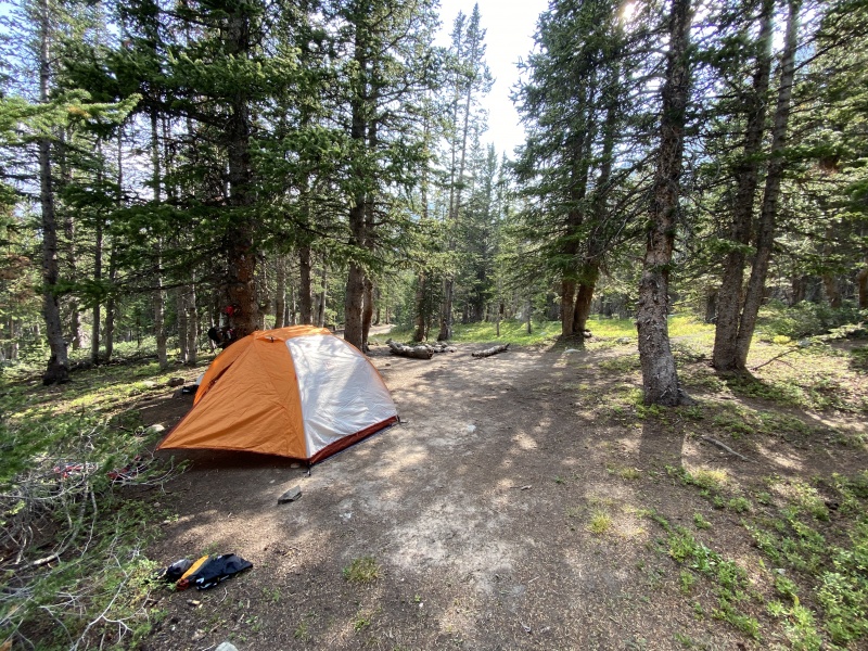
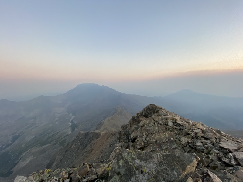
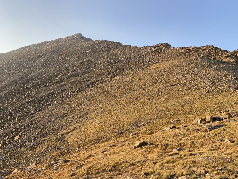
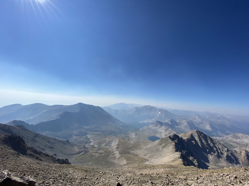
My camp site just above the H/C trail split. There is a lot of excellent sites all around the basin.Summit of Columbia shortly after 6AM. Looking NW towards Harvard. It was pretty smokey from all the wild fires in the AM but the wind shifted by 8AM and the smoke cleared mostly. I never felt it in my lungs. Grateful for all the firefighters out there who have their hands full right now.The initial descent of Columbia. I found this to be very steep, loose, and long. I can't imagine doing this UP on tired legs. At this point on the C->H traverse is when you need to go down way more than you think to avoid an unseen cliff band before entering the talus basin. There is a cairn showing where to enter (or exit if going H -> C).This picture is just above the traverse low point on my way back up to H (taking the Tommyboy "layup" around point 13,516). You can see the entirety of the talus basin below the "Rabbit" (visible in the picture just right of center). Columbia is the high point in the background on the left. It took me about 2 hours from the summit of Columbia to this point. Again, I followed Tommyboy's trip report linked higher up which is as excellent a guide through this difficult area as is out there. No picture does this area justice but take my word, there is a TON of talus in here.Summit of Harvard looking into the beautiful basin. Took me 3.5 hours peak to peak. Columbia, Yale, and Princeton in view plus Bear Lake. Met a number of day hikers going to the lake for the day.Looking back up towards Harvard from Horn Fork basin. Harvard summit is the high point left of center.Columbia mastiff from horn fork basin. Summit is high bump left of center. The route goes up the shoulder on the right which you can't really see.
Thumbnails for uploaded photos (click to open slideshow):
were difficult to see going the other way too! This route is just challenging no matter how you slice it. Thanks for the report; it's good for the next generation on this "trail".
Yeah - there is a heavy stream flowing through the area that was maybe 200 yards from my site.
Caution: The information contained in this report may not be accurate and should not be the only resource used in preparation for your climb. Failure to have the necessary experience, physical conditioning, supplies or equipment can result in injury or death. 14ers.com and the author(s) of this report provide no warranties, either express or implied, that the information provided is accurate or reliable. By using the information provided, you agree to indemnify and hold harmless 14ers.com and the report author(s) with respect to any claims and demands against them, including any attorney fees and expenses. Please read the 14ers.com Safety and Disclaimer pages for more information.
Please respect private property: 14ers.com supports the rights of private landowners to determine how and by whom their land will be used. In Colorado, it is your responsibility to determine if land is private and to obtain the appropriate permission before entering the property.


")
")
")
")
")
")
")
")