Log In 
Elevation 14,175' (LiDAR)
Prev Elevation 14,159'
CO 14er Rank Unranked
Range San Juan
Forest San Juan
County Dolores
Towns Ouray, Telluride, Rico
El Diente Peak

Photos

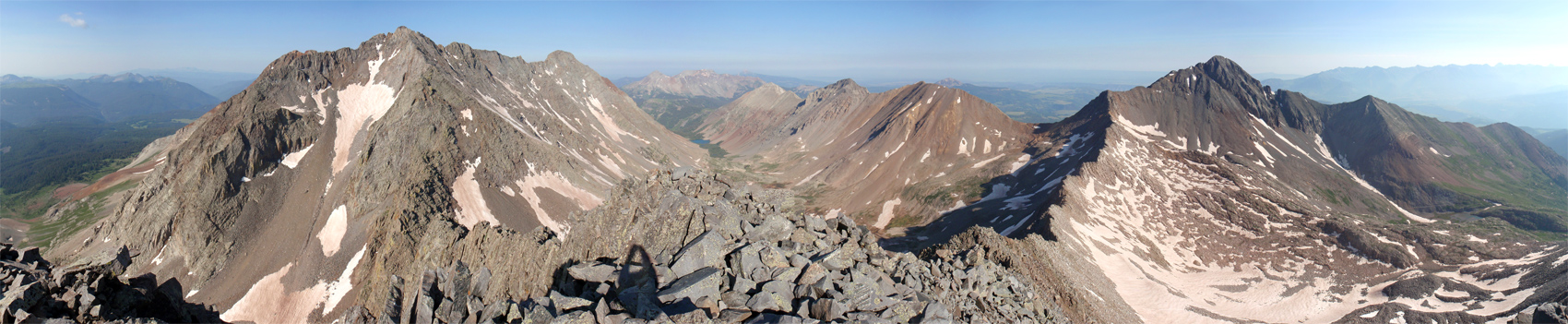
360 Pano
360° Summit Pano
pic1
pic2
pic3
pic4 pic5 pic6 pic7 pic8
pic9
pic10
pic11 pic12 pic13 pic14 pic15 pic16
pic17
pic18 pic19 pic20

Climbing Routes

route
Navajo Lake Approach
Difficulty: Class 1
Total Elevation Gain: 2,000'
Round-trip Distance: 9.5 mi
Exposure: Low
Rockfall Potential: Low
Route-Finding: Low
Commitment: Low
route
Rock of Ages Approach
Difficulty: Class 1
Total Elevation Gain: 2,800'
Round-trip Distance: 8.5 mi
Exposure: Moderate
Rockfall Potential: Low
Route-Finding: Low
Commitment: Low
route
Kilpacker Approach
Difficulty: Class 1
Total Elevation Gain: 800'
Round-trip Distance: 6 mi
Exposure: Low
Rockfall Potential: Low
Route-Finding: Low
Commitment: Low
route
Woods Lake Approach
Difficulty: Class 1
Total Elevation Gain: 2,115'
Round-trip Distance: 9 mi
Exposure: Low
Rockfall Potential: Low
Route-Finding: Low
Commitment: Low
route
Wilson Peak - Southwest Ridge Standard Route
Difficulty: Class 3
Total Elevation Gain: 3,900'
Round-trip Distance: 10 mi
Exposure: High
Rockfall Potential: Considerable
Route-Finding: Considerable
Commitment: Considerable
route
El Diente Peak - South Slopes Standard Route
Difficulty: Class 3
Total Elevation Gain: 4,400'
Round-trip Distance: 12 mi
Exposure: Considerable
Rockfall Potential: Considerable
Route-Finding: High
Commitment: Considerable
route
Mt. Wilson - Southwest Slopes Standard Route
Difficulty: Class 3
Total Elevation Gain: 4,400'
Round-trip Distance: 12.5 mi
Exposure: High
Rockfall Potential: Considerable
Route-Finding: Considerable
Commitment: Considerable
route
Mt. Wilson - North Slopes
Difficulty: Class 4
Total Elevation Gain: 5,100'
Round-trip Distance: 16 mi
Exposure: High
Rockfall Potential: High
Route-Finding: High
Commitment: Considerable
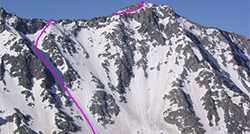
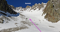
route
El Diente Peak - North Slopes
Difficulty: Class 3
Total Elevation Gain: 5,000'
Round-trip Distance: 15 mi
Exposure: Considerable
Rockfall Potential: Considerable
Route-Finding: High
Commitment: Considerable
route
Combo: Mt. Wilson + El Diente Traverse
Difficulty: Class 4
Total Elevation Gain: 500'
Round-trip Distance: 1 mi
Exposure: High
Rockfall Potential: High
Route-Finding: High
Commitment: High
route  _
El Diente Peak - North Buttress
Difficulty: Class 4
Total Elevation Gain: 3,200'
Round-trip Distance: 5 mi
Exposure: High
Rockfall Potential: Considerable
Route-Finding: High
Commitment: High
route  _
Mt. Wilson - East Face
Difficulty: Class 3  Moderate Snow
Total Elevation Gain: 4,900'
Round-trip Distance: 12 mi
Exposure: High
Rockfall Potential: Considerable
Route-Finding: High
Commitment: High

Map

Human Verification Required

Trip Reports

  8 Recent Reports Peaks Climbed Added
  El Diente from Kilpacker dayhike
By: Paul M
Added: 8/9/2026
El Diente Peak 8/3/2026 8/9/2026 8  35
  of chafe and character-building Google Map Included GPX file available for download
By: EvanKBlack
Added: 7/30/2026
San Luis Peak
El Diente Peak
Mt. Wilson
Wilson Peak
Mt. Sneffels
Mt. Lindsey
7/22/2026 7/30/2026 9  24
  SOLO Day Hiking the Winter 14ers
By: illusion7il
Added: 4/26/2026
Mt. Eolus
North Eolus
Sunlight Peak
Windom Peak
Capitol Peak
Pyramid Peak
Snowmass Mountain
Maroon Peak
North Maroon Peak
Mt. Wilson
El Diente Peak
Wilson Peak
Mt. of the Holy Cross
Little Bear Peak
Longs Peak
12/22/2025 4/26/2026 31 
  New snow for fun day
By: jace_reber
Added: 10/1/2025
El Diente Peak
Mt. Wilson
9/28/2025 10/1/2025 5  4
  Four Nights at the Wilson Group
By: jcbmaverick
Added: 9/7/2025
Wilson Peak
Mt. Wilson
El Diente Peak
9/4/2025 9/7/2025 7  21
  Video Trip Report: Colorado 14er El Diente, July 2024
By: mikjik86
Added: 1/20/2025
El Diente Peak 7/11/2024 1/20/2025 5 
  Mt Wilson + El Diente via the new standard routes, no traverse
By: caesarsalad
Added: 8/1/2024
Mt. Wilson
El Diente Peak
7/29/2024 8/1/2024 13  16
  El Diente (via North Buttress) + Traverse to Mt Wilson
By: tygr
Added: 9/5/2023
El Diente Peak
Mt. Wilson
9/5/2023 9/5/2023 2  22
View All 180 Trip Reports

Frequently Asked Questions about El Diente Peak

Do I need a permit to camp in Kilpacker Basin when climbing El Diente?

No, you do not need to secure a pre-booked wilderness permit or reservation to camp in the Lizard Head Wilderness. Unlike neighboring Navajo Basin, there are no designated campsite restrictions or site regulations in the Kilpacker Basin yet. You are free to utilize traditional dispersed backpacking campsites, provided you follow standard wilderness rules by pitching your tent at least 100 feet away from streams, lakes, and developed trails.

How difficult is the El Diente to Mount Wilson traverse and what is the best approach?

The legendary El Diente to Mount Wilson Traverse is a serious, high-consequence Class 4 mountaineering route with exposure, loose rock, and complex route-finding. To tackle it safely, approaching the traverse from the south via the Kilpacker Basin is generally considered the easiest and most efficient method. Starting from Kilpacker offers a shorter, less fatiguing approach day and allows you to ascend El Diente's standard South Slopes first before tracking across the ridge. Then, descending Mt. Wilson's Southwest Slopes route.

Can I climb Mount Wilson, El Diente Peak, and Wilson Peak all in one day?

Bagging all three summits in a single day creates a massive, grueling endurance day. If you choose to attempt it, the most efficient method is to start at the Navajo Lake or Rock of Ages trailhead and ascend El Diente Peak's North Slopes route first, then traverse across the ridge crest to Mount Wilson, and hit Wilson Peak on your way back out. To do this safely, you should aim for early summer so you can climb the unstable North Slopes of El Diente when the couloir is filled with consolidated snow, avoiding severe summer rockfall hazards.

What is the naming history of this peak group and why are there two "Wilsons"?

The naming duplication dates back to the historical 1874 Hayden Geological Survey. Topographer A.D. Wilson climbed the highest point in the local cluster, which was officially named Mount Wilson (14,246 feet) in his honor. Later, when surveyors realized there was a completely separate, highly prominent independent 14er horn sitting just two miles directly north, they named it Wilson Peak (14,017 feet) after him as well. To round out the group, the adjacent jagged tooth was aptly given the Spanish name El Diente ("The Tooth").

Additional El Diente Peak History

Name History 1
Climbing History 0
Mining 0
Geology 1
More Information 0
  View All