Log In 
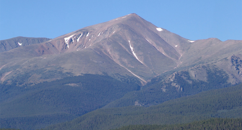
At 14,438', Mount Elbert is the highest mountain in Colorado, the highest of the Rocky Mountains, and the second-highest in the contiguous United States. Elbert is in the Sawatch Range near the city of Leadville, a 2 hour drive from Denver. Climbing Mt. Elbert is relatively easy compared to many other 14ers and you'll find a trail all the way to the summit, with stunning views over the upper Arkansas River Valley and across the expansive Sawatch. But don't be fooled - getting to the summit is an arduous trek if you're not used to climbing high peaks. It's one of the easiest 14ers in Colorado and sometimes a first 14er climb for beginners.
Elevation 14,438' (LiDAR)
Prev Elevation 14,433'
CO 14er Rank 1 of 53
Range Sawatch
Forest San Isabel
County Lake
Towns Leadville, Twin Lakes, Aspen
Mt. Elbert

Photos

360 Pano
360° Summit Pano
pic1
pic2
pic3
pic4 pic5 pic6 pic7 pic8 pic9 pic10 pic11 pic12 pic13
pic14
pic15
pic16 pic17 pic18 pic19 pic20 pic21 pic22 pic23 pic24
pic25
pic26
pic27
pic28
pic29 pic30 pic31 pic32 pic33 pic34 pic35
pic36

Climbing Routes

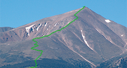
route
Mt. Elbert - Northeast Ridge Standard Route
Difficulty: Class 1
Total Elevation Gain: 4,500'
Round-trip Distance: 9.75 mi
Exposure: Low
Rockfall Potential: Low
Route-Finding: Low
Commitment: Low
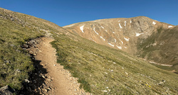
route
Mt. Elbert - East Ridge
Difficulty: Class 1
Total Elevation Gain: 4,200'
Round-trip Distance: 11.25 mi
Exposure: Low
Rockfall Potential: Low
Route-Finding: Low
Commitment: Moderate
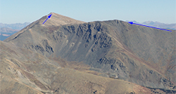
route
Mt. Elbert - Southeast Ridge
Difficulty: Class 2
Total Elevation Gain: 5,300'
Round-trip Distance: 10.5 mi
Exposure: Low
Rockfall Potential: Moderate
Route-Finding: Moderate
Commitment: Moderate
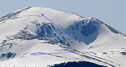
route  _
Mt. Elbert - Box Creek Couloirs
Difficulty: Difficult Class 2  Moderate Snow
Total Elevation Gain: 4,200'
Round-trip Distance: 10 mi
Exposure: Considerable
Rockfall Potential: Moderate
Route-Finding: Moderate
Commitment: Considerable

Map

Human Verification Required

Trip Reports

  8 Recent Reports Peaks Climbed Added
  Elbert North and the Gang
By: Pelotondon
Peak(s): Mt. Elbert
Added: 5/31/2026
Mt. Elbert 5/30/2026 5/31/2026 3  11
  Mt Elbert, Cosgriff and Bull Hill Loop Google Map Included GPX file available for download
By: CaptainSuburbia
Added: 12/4/2025
Mt. Elbert
Bull Hill
Mt. Cosgriff
11/10/2025 12/4/2025 12  48
  Elbert Northeast ridge
By: Krispy
Peak(s): Mt. Elbert
Added: 9/21/2025
Mt. Elbert 9/16/2025 9/21/2025 2  4
  Mt. Elbert - Northwest Ridge
By: htownbrewer
Peak(s): Mt. Elbert
Added: 9/17/2025
Mt. Elbert 9/5/2025 9/17/2025 3  4
  Tour de 14ers Bikepack - Summer 2025
By: Cool Hand Luke
Added: 8/11/2025
Mt. Elbert
Blanca Peak
Uncompahgre Peak
Mt. Lincoln
Castle Peak
Mt. Blue Sky
Mt. Wilson
All 58 14ers
6/16/2025 8/11/2025 15  50
  Elbert - East Ridge from South TH
By: gprovost
Peak(s): Mt. Elbert
Added: 8/8/2025
Mt. Elbert 8/7/2025 8/8/2025 2  4
  Elbert - NE Ridge, Fifth of July...
By: nickdanielson
Peak(s): Mt. Elbert
Added: 7/5/2025
Mt. Elbert 7/5/2025 7/5/2025 4  4
Quest to 100 / Part 2: Bagging the Big Boys Before the Summer Swarms / #20 to #33 Google Map Included GPX file available for download
By: notidealbutfine
Added: 6/2/2025
Mt. Yale
La Plata Peak
Pikes Peak
Fletcher Mountain
Mt. Elbert
"Lackawanna"
Torreys Peak
Mt. Blue Sky
Mt. Democrat
Mt. Sherman
4/25/2025 6/2/2025 5  44
View All 454 Trip Reports

Frequently Asked Questions about Mt. Elbert

Is Mount Elbert good for beginner 14er hikers?

Yes, Mount Elbert is widely considered one of the safest and most straightforward introductory 14ers in Colorado. The standard Northeast Ridge route is a non-technical Class 1 walk-up with a well-maintained, easy-to-follow trail. However, hikers must not underestimate it; as it requires a strenuous 9.5-mile round-trip trek with 4,700 feet of relentless elevation gain that demands strong cardiovascular physical conditioning.

Can I camp near the standard Mount Elbert Trailhead?

Yes, the Halfmoon Creek Road leading to the standard North Trailhead is one of the premier camping corridors in the Sawatch Range. There is extensive, free dispersed car camping at established pullouts all along the dirt road, many of which sit directly alongside the creek. Because this area is incredibly popular with hikers, camping spots fill up rapidly on summer weekends, so you should aim to arrive early on Thursday or Friday morning to secure a site.

Are there developed USFS campgrounds on Halfmoon Creek Road?

Yes, if you prefer managed amenities over dispersed camping, the U.S. Forest Service operates three developed sites along the road. Elbert Creek Campground is located directly across the street from the North Mount Elbert Trailhead, while Halfmoon East and Halfmoon West campgrounds are located just a few miles further down the road. These locations operate on a first-come, first-served basis, cost a nightly fee, and provide vault toilets, picnic tables, and fire rings, but do not offer drinking water or trash services.

What is the standard hiking route for Mount Elbert and how long does it take?

The standard and most popular path is the Northeast Ridge route, which begins at the North Mount Elbert Trailhead off Halfmoon Creek Road. The hike takes the average, well-acclimated person between 5 and 7 hours to complete round-trip. To avoid the danger of afternoon alpine lightning storms above the tree line, you should plan your itinerary to start from the trailhead no later than 5:00 AM unless the weather is forecasted to be sunny all day.

Additional Mt. Elbert History

Name History 1 Climbing History 1
Mining 0
Geology 0
More Information 0
  View All