Log In 
Photo

Mount Elbert

East Ridge
Difficulty Class 1 
Ski/Board: Intermediate, D3 / R1 / III  
Risk FactorsExposure: Low
Rockfall Potential: Low  
Route-Finding: Low  
Commitment: Low  
 
Start10,500 feet
Summit14,438 feet
Total Gain4,100 feet (starting at the end of the 4WD road)
4,900 feet (starting at the paved TH)
RT Length10.50 miles (starting at the end of the 4WD road)
14.50 miles (starting at the paved TH)
Last UpdatedMay 2025
Show More
Photo
A Note from CFI
CFI
Colorado Fourteeners Initiative trail crews will return to Mt. Elbert in summer 2025 to clear corridor, place updated signage, install stone barriers, extend fencing, and build check steps to help guide hikers onto the new trail and stay off the old trail. If you encounter CFI trail-builders when hiking, please alert them to your presence so they can help you pass by safely.

Trailhead

From U.S. 24 south of Leadville, take Colorado 82 west toward Twin Lakes. Drive about 4 miles and turn right onto the 24 road. Drive 1.2 miles up a hill to the main trailhead parking area (paved) on the left. This is the lower trailhead and 2WD vehicles should park here. Continue 50 feet past the lower TH and turn left on Forest Service road 125.1B (4WD). From here it's 1.8 miles to the upper trailhead. Walk or drive up the 4WD road to reach the start of the trail.

Along the 4WD road there are several pull-offs and camping spots. Near 0.5 mile there's usually rough section of road but most 4WD vehicles should be able to get past it. Near 1.6mi, cross a small stream. Continue to a parking area with information kiosk at 1.8mi. This is the trailhead.

Route Description

 1 shows the general route. Start from the 4WD parking area and cross a small creek using a footbridge ( 2). Follow the Colorado/Continental Divide Trail through willows, keeping left at a small trail junction ( 3). Continue through a section of aspens for about 0.4 mile, descend slightly, then turn left at another junction ( 4). Walk a bit farther and stay left at yet another junction ( 5). Now on the South Mt. Elbert Trail, follow it through the forest ( 6). At around 11,400', the forest begins to thin as you approach the ridge ( 7). Ascend the ridge, passing through a clearing at 11,600' ( 8). Turn left and ascend to a corner where you'll get a beautiful view of Mt. Elbert ( 9). From there, turn right and traverse north ( 10), regaining the west side of the ridge near 12,200' ( 11). Continue a short distance to reach a saddle on the ridge.

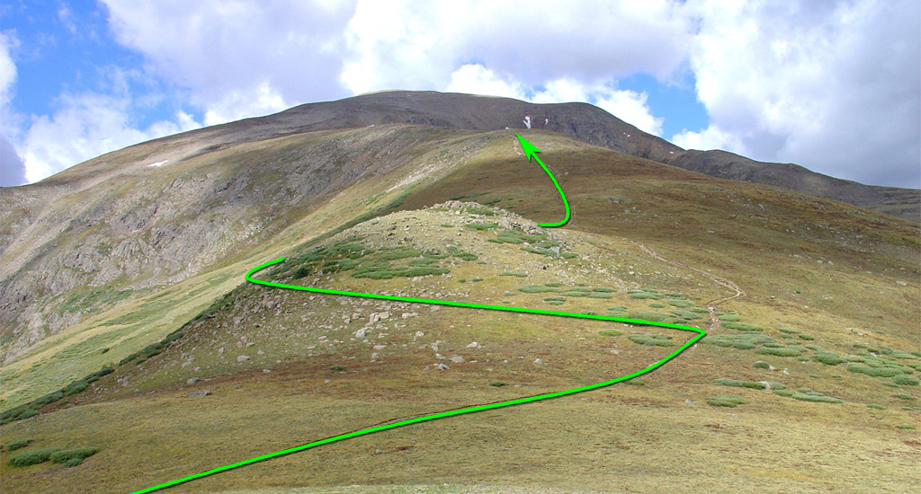
From the saddle, the route becomes more challenging as you'll need to gain 2,000 feet of elevation over the remaining 2 miles ( 12). In recent years, the Colorado Fourteeners Initiative (CFI) has improved and re-routed portions of this trail, so you may notice some closed-off, older trail sections. Leave the saddle, turning left to bypass an initial point ( 13), swing to the right side of the ridge, then regain the ridge crest near 12,500' ( 14). Hike west along the ridge ( 15), passing a large rock to reach a flat spot at 12,900' ( 16). Continue to 13,200', where you'll see the route's crux—a steep section between 13,400' and 13,800' ( 17). Push through this steep part, then swing left to ascend Mt. Elbert's southeast face ( 18). Traverse partway across the face before climbing 600 feet more to reach the summit ridge. Finally, turn left and follow the ridge to the summit ( 19,  20,  21).
In Winter

This is Elbert's safest winter route because there is rarely avalanche danger along the east ridge.

Skiing?

The east ridge isn't a great ski but it does often hold enough snow for a continuous descent.
#1 #2 #3 #4 #5 #6 #7 #8 #9 #10 #11 #12 #13 #14 #15 #16 #17 #18 #19 #20 #21

This page is only available to registered 14ers.com users. If you don't have an account, you can register in the forum.

Log In_

This page is only available to registered 14ers.com users. If you don't have an account, you can register in the forum.

Log In_

This page is only available to registered 14ers.com users. If you don't have an account, you can register in the forum.

Log In_

Caution: The information contained in this route may not be accurate and should not be the only resource used in preparation for your climb. Failure to have the necessary experience, physical conditioning, supplies or equipment can result in injury or death. 14ers.com and the author(s) of this route provide no warranties, either express or implied, that the information provided is accurate or reliable. By using the information provided, you agree to indemnify and hold harmless 14ers.com and the route author(s) with respect to any claims and demands against them, including any attorney fees and expenses. Please read the 14ers.com Safety and Disclaimer pages for more information.

Please respect private property: 14ers.com supports the rights of private landowners to determine how and by whom their land will be used. In Colorado, it is your responsibility to determine if land is private and to obtain the appropriate permission before entering the property.
Heading to a 14er soon? Don't forget the 14ers.com mobile app.
Google Play     Apple App Store