Download Agreement, Release, and Acknowledgement of Risk:
You (the person requesting this file download) fully understand mountain climbing ("Activity") involves risks and dangers of serious bodily injury, including permanent disability, paralysis, and death ("Risks") and you fully accept and assume all such risks and all responsibility for losses, costs, and damages you incur as a result of your participation in this Activity.
You acknowledge that information in the file you have chosen to download may not be accurate and may contain errors. You agree to assume all risks when using this information and agree to release and discharge 14ers.com, 14ers Inc. and the author(s) of such information (collectively, the "Released Parties").
You hereby discharge the Released Parties from all damages, actions, claims and liabilities of any nature, specifically including, but not limited to, damages, actions, claims and liabilities arising from or related to the negligence of the Released Parties. You further agree to indemnify, hold harmless and defend 14ers.com, 14ers Inc. and each of the other Released Parties from and against any loss, damage, liability and expense, including costs and attorney fees, incurred by 14ers.com, 14ers Inc. or any of the other Released Parties as a result of you using information provided on the 14ers.com or 14ers Inc. websites.
You have read this agreement, fully understand its terms and intend it to be a complete and unconditional release of all liability to the greatest extent allowed by law and agree that if any portion of this agreement is held to be invalid the balance, notwithstanding, shall continue in full force and effect.
By clicking "OK" you agree to these terms. If you DO NOT agree, click "Cancel"...
I successfully climbed Mt Wilson from the Kilpacker TH on Saturday, 30 August 2025. This peak represented some unfinished business for me as I had previously attempted it via the Navajo Lakes basin over a decade ago, but was knocked off the traverse from El Diente Peak due to inclement weather. This route is very heavily documented and I didn't encounter anything that deviated from the route description on this website (here and here) or that I thought needed significant highlighting that isn't documented elsewhere. So in lieu of a full report, I've just listed my thoughts below in a "Mini" TR format.
My splits, GPX file, and other useful information is included below. Thanks for reading.
THE TRAILHEAD
There is a clutch Conoco right off CR 145 after the road turns south at the roundabout - a great spot for a gas top off and the mens' bathroom was reasonably clean
FR 535/Dunton Rd is a very mellow, albeit narrow, dirt road; I put my stock Xterra into 4WD for no other reason except that I could
The signed Kilpacker TH has lots of room for cars and tents, but was pretty full the day I climbed with cars parked all the way back to FR 535
Bonus: El Diente Peak is visible from the TH to the north
THE TRAIL
The trail from the TH into the basin is about as chill an approach trail as exists and actually loses more elevation than it gains through the forest
I went climber's right across the creek on the way up (east) and climber's left (west) on descent, both on some wet but solid logs; climber's left seemed to be the easier method
I saw no signs of the recent cougar sightings, but I wasn't looking either... I did see an owl and quite a few deer
I saw lots of day-hikers in addition to climbers/back-packers on my way out of the basin
This is really a beautiful area... I savored the views behind me on descent
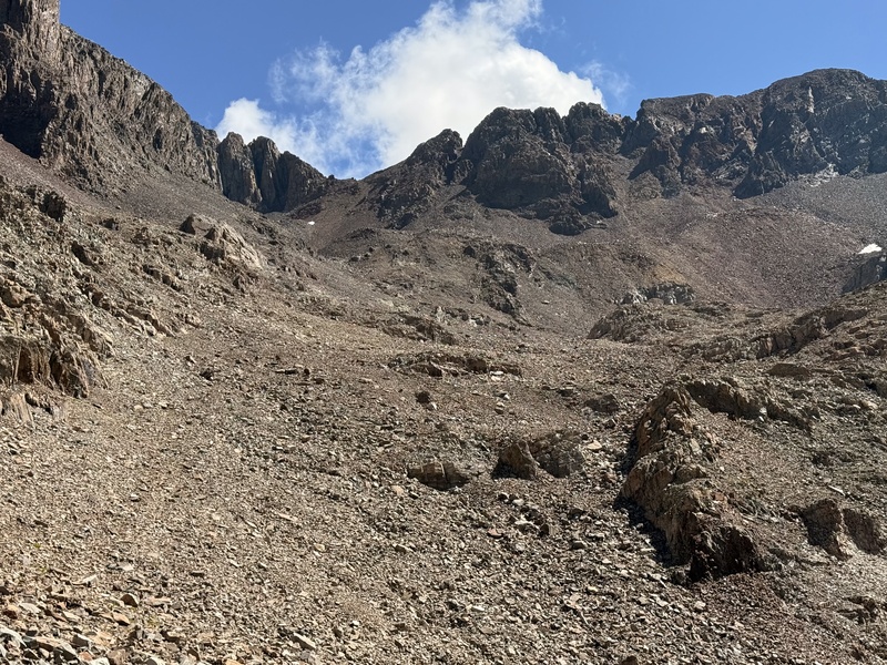
THE TALUS
Holy Mother is there a ton of talus in this basin, and combined with my skill of only ever finding the boulders that move, this was the ultimate talus grind of a hike
While the snow was basically gone from the upper reaches of basin, the previous days' rains and cool overnight temperatures left an annoying layer of frost on everything, turning my already slow place through the talus fields into a glacial slog
I observed other hikers enjoying the sunshine of the El Diente traverse while I toiled and slipped my way in the shade the entire way up; once the sun peaked over the Mt Wilson summit ridge, the rocks warmed up and were much more tolerable on descent
THE SUMMIT
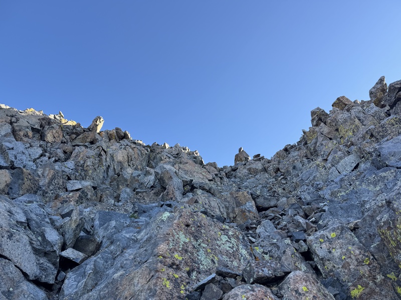
The route description and associated photos (especially this one and this one) for the gulley rib crossover and surrounding Class 3 climbing are spot-on and I had no issues navigating the upper difficulties (other than the icy rocks)
In addition to the slippery talus, a lot of the boulders are incredibly loose, even right near the summit; it probably goes without saying but I recommend double-checking holds throughout this entire climb
I also recommend a helmet for this hike; I observed multiple rockfalls while climbing, including from the El Diente traverse route (which traverses directly above the upper portions the start of the Class 3 section of this route)
Wow is Mt Wilson a cool summit when coming from this direction; the rest of the Wilson Group (minus El Diente) doesn't come into view until the absolute end of the climb, and the emergence of Wilson Peak and Gladstone Peak to the north was epic
I had excellent Verizon service on the summit; enough to FaceTime my kids who got a kick out of mountains being called "El Diente" ("The Tooth"), "Sneffels" ("Snuffels" to my 3-year-old), and "Lizard Head"
This is a really beautiful area; I savored it on my hike out. El Diente Peak is to the left (north) in this photo. Mt Wilson is not visible at this point. (Photo taken on descent.)Approaching the upper basin near the El Diente Peak trail split. Good lord just look at that talus. The Mt Wilson ridge comes into view around here, including sub-summit South Wilson, but the very private Mt Wilson summit remains hidden to the left (north). (Photo taken on descent.)In the upper basin approaching the prominent boulder pile with Mt Wilson straight ahead. All of these rocks were wet and slippery after the previous days' rains, and all threatened to move.Heading up the final bit of talus towards the gulley and rib crossover; the frost-covered rocks made for an annoyingly slow grind up this section.The view east towards Mt Wilson's summit and the gullies/rib crossover. The 14ers.com route description is dead-on for this section of mild route-finding (see photo #10 and photo #11). The traverse from El Diente Peak is directly above this area and I observed multiple rockfalls (not necessarily due to other climbers). A helmet is a must for this route.The upper gulley past the rib crossover continued the trend of stubbornly wet, icy, and loose talus. I stayed climber's left against the large boulders for the most part.The final summit pitch was the most enjoyable class 3 climbing of the day, though the rock was quite loose, including a couple large boulders that moved on me.Back at the Kilpacker TH, looking north towards El Diente Peak and the surrounding peaks. (Photo taken on descent.)
SPLITS:
Saturday, 30 August 2025
Start from Kilpacker TH: 03:24 MT
Creek Crossing: 04:24 MT (01:00)
End of Trail/Start of Talus: 05:14 MT (01:50)
El Diente Split: 06:24 MT (03:00)
Top of Talus/Start of C3 Climbing: 08:04 MT (04:40)
Thumbnails for uploaded photos (click to open slideshow):
Comments or Questions
Caution: The information contained in this report may not be accurate and should not be the only resource used in preparation for your climb. Failure to have the necessary experience, physical conditioning, supplies or equipment can result in injury or death. 14ers.com and the author(s) of this report provide no warranties, either express or implied, that the information provided is accurate or reliable. By using the information provided, you agree to indemnify and hold harmless 14ers.com and the report author(s) with respect to any claims and demands against them, including any attorney fees and expenses. Please read the 14ers.com Safety and Disclaimer pages for more information.
Please respect private property: 14ers.com supports the rights of private landowners to determine how and by whom their land will be used. In Colorado, it is your responsibility to determine if land is private and to obtain the appropriate permission before entering the property.


")
")
")
")
")
")
")
")


