Download Agreement, Release, and Acknowledgement of Risk:
You (the person requesting this file download) fully understand mountain climbing ("Activity") involves risks and dangers of serious bodily injury, including permanent disability, paralysis, and death ("Risks") and you fully accept and assume all such risks and all responsibility for losses, costs, and damages you incur as a result of your participation in this Activity.
You acknowledge that information in the file you have chosen to download may not be accurate and may contain errors. You agree to assume all risks when using this information and agree to release and discharge 14ers.com, 14ers Inc. and the author(s) of such information (collectively, the "Released Parties").
You hereby discharge the Released Parties from all damages, actions, claims and liabilities of any nature, specifically including, but not limited to, damages, actions, claims and liabilities arising from or related to the negligence of the Released Parties. You further agree to indemnify, hold harmless and defend 14ers.com, 14ers Inc. and each of the other Released Parties from and against any loss, damage, liability and expense, including costs and attorney fees, incurred by 14ers.com, 14ers Inc. or any of the other Released Parties as a result of you using information provided on the 14ers.com or 14ers Inc. websites.
You have read this agreement, fully understand its terms and intend it to be a complete and unconditional release of all liability to the greatest extent allowed by law and agree that if any portion of this agreement is held to be invalid the balance, notwithstanding, shall continue in full force and effect.
By clicking "OK" you agree to these terms. If you DO NOT agree, click "Cancel"...
I'll first apologize for the obscene lag time since we did this climb until posting this TR. We did the climb last fall and while I thought it was TR worthy I let the winter be an excuse for not posting it immediately. Recently goaded by Milan, who I met on Eolus, and a number of others interested in the Back Way up Wilson, I decided that this was worth doing for the community. The part of the climb that should be relevant is the last third, from upper Kilpacker basin to the summit and that is the part documented here. The standard route on El Diente will provide route information on the lower part of the hike and has not been included.
A couple of general comments. We were interested in this climb as an alternative to the standard exposed crux on Mt. Wilson's summit. Imagine our surprise when we found ourselves in exactly the same spot from the opposite side of the mountain! Time to backtrack, and that's part of what's fun about climbing.
This climb is about the same in terms of difficulty as El D, IMO. Some loose, some exposure, some slick dirt, but overall about the same amount of challenge. The trail is less beaten down and more care should be given because of that but it's the Wilsons and they're supposed to move around!
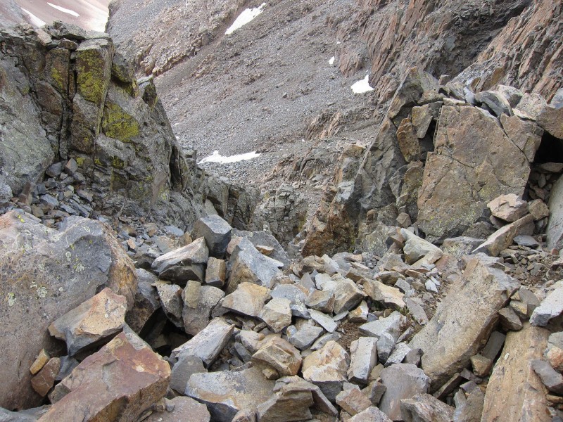
The only area that bothered me a little was the large talus and boulders just before you get into the upper couloirs. This route does not get enough traffic to settle and compact it. As a result, very large blocks move freely and that's just not a personal favorite of mine. The images were all taken on the way down in early afternoon and things may appear a little different in morning light. That sounds obvious, but has an impact in my mind.
One warning: I would not climb this route if there has been significant rain. The unstable nature of the rock and the dirt that holds it together would be much worse if the soils were wet. I'd stay away after heavy rain.
Thanks also to the other members on this climb who provided some of the pictures.
The Route:
Mt. Wilson cannot be seen in the lower part of the basin as it is screened by the ridge from El D. Wilson coming into view
As you climb higher it begins to rear above you but is foreshortened and not very impressive from a distance. The summit appears
Start to aim for the left side of the drainage. lingering snow fields in September
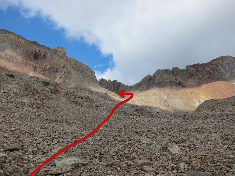
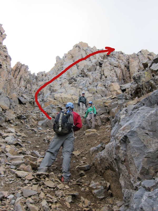
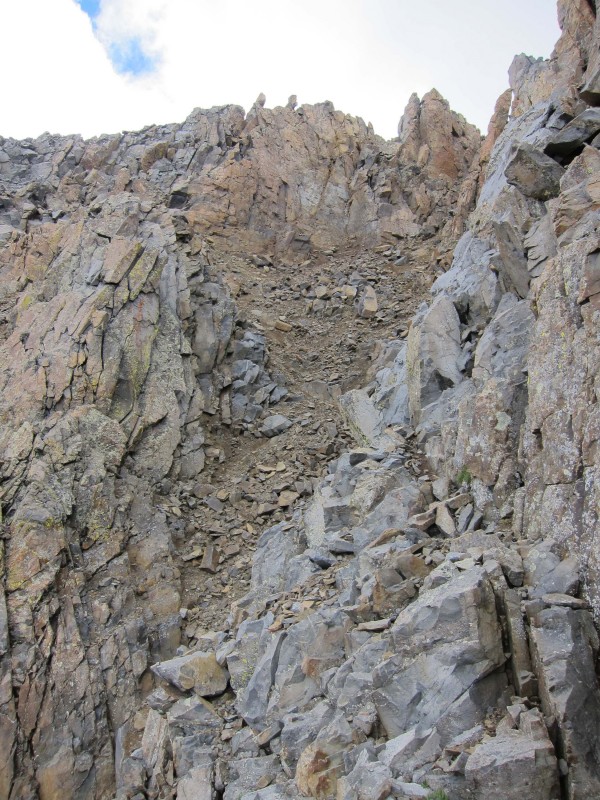
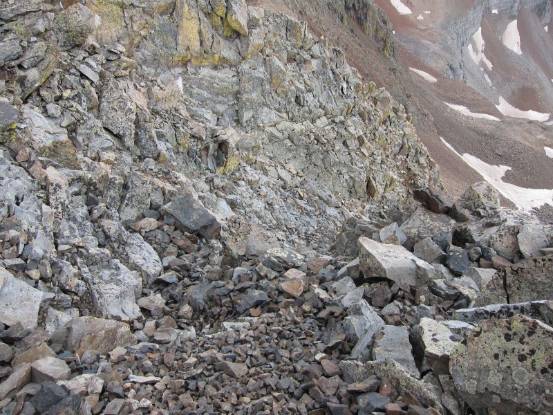
You will reach an area of large talus and boulders. Stay to the left and scout for a route through the initial steep terrain below the upper couloirs. There are several ways through this area. Take the path of least resistance. The route into the couloir
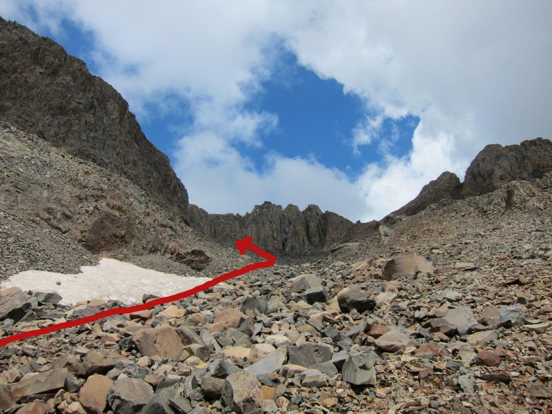
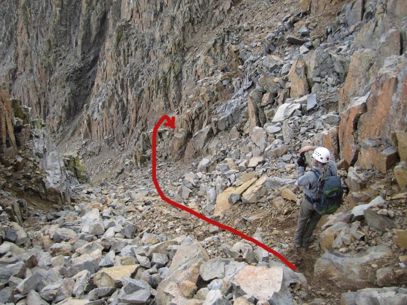
The view from the area just above shows the couloir branching left with a large rock rib in the center. View of the crossover from below
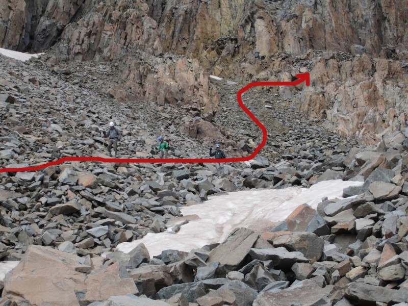
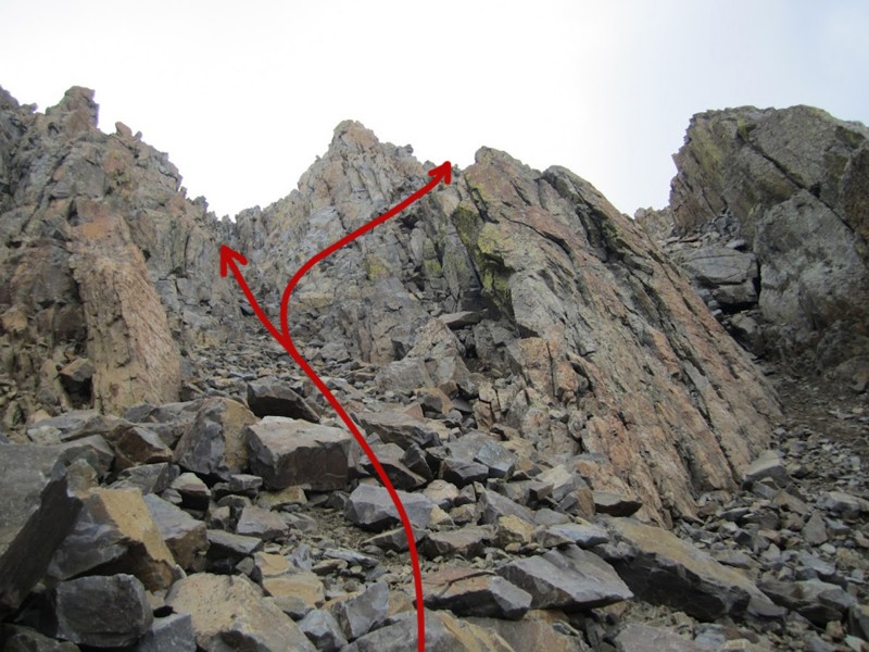
There are three options at this point. Left and up, takes you to the standard route crux. Right takes you to a class 4/low 5 headwall. The middle option, which takes you up and over the rock rib leads to easier ground above the headwall to the right. Close-up of crossover
This view is up the steep, narrow couloir to the standard crux. View up wrong couloir to standard crux
The terrain in this area is steep, but not a steep as the image conveys. This picture was taken while waiting for others to descend from above while in a safe niche. steepness of terrain near crossover
The climb over the rock rib is not as hard as it looks but is easy to miss on the way up. There was no cairn. Pay attention to your right as you ascend. climb up the rib
Once you've gained the top of the rock rib, this is the view up the gulley to the standard crux. It's not as steep as it looks. view of upper couloir to standard crux
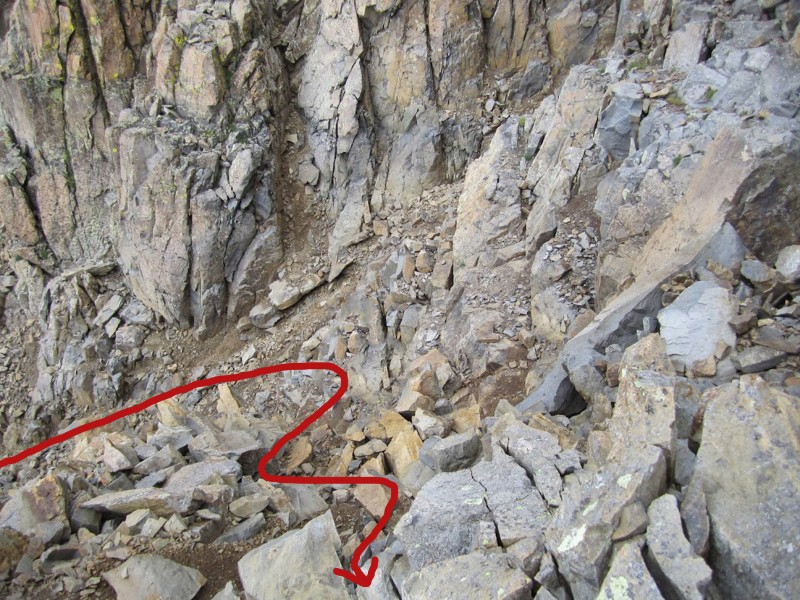
A view down from this area shows a steep drop to the left. Aim right on your descent. It is more obvious on the descent. just above steep shelf, turn right
This shows the route from higher up and indicates where to start looking for the crossover. There are several ways across the rib, lower options were easier. crossover from above
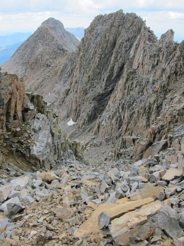
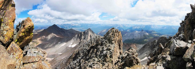
Here is a broader view, showing the relationship to El D and the connecting ridge. view down couloir with El D and ridge
Another image from higher up the gulley nearing easier terrain around the summit.
Terrain just below the summit. terrain near the summit
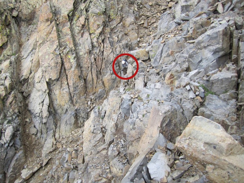
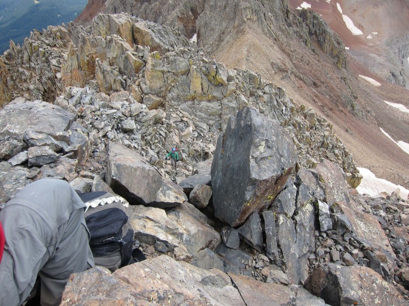
Looking down on a climber approaching the top. climber approaching summit
Happy climbers on the summit!
A bonus view from the notch on the standard crux route.
An aerial view showing the route as a snow climb. I think this corresponds pretty closely with the TRs posted by Carl and Benners.
Thumbnails for uploaded photos (click to open slideshow):
I actually descended Mt. Wilson with that route. I was in the process of writing an informative report about the west face, but now I dont have too!!! Good job. I don't know if its just me but I don't think the route exceeds class 3?
This trip report answered all of my questions, as you know, I am heading there this afternoon and will try on Sunday. Greatly described and the poctures show it all!. I appreciate your help.
Doctor No: It was fun. Do it if you get the chance.
Rcizzle: Yes, it was never more than class three. Little real exposure as well. Somewhat loose but that's the Wilsons. :)
Sunny1: Thank you. And thanks for embellishing some of my pics.
Good partners are everything.
49ersRule: Never enough. How about September? If only you'd do repeats...
jasayrevt You're welcome, have fun with Milan if you see him.
lordhelmut: Thanks, Brian. I had thought I pissed the sherriff off when I told him he wasn't my type. Maybe he was thicker skinned than I gave him credit.
Milan: You're welcome. Be safe and tell us how you do...
Thanks a bunch for uploading this report, I'll be attempting with Milan this weekend. The pictures are extremely helpful!
Also, from the pictures it looks like there are boulders upon boulders that look like they are literally a flick away from being sent tumbling. Pretty spooky, is that the reality or is it not THAT bad? Of course I'll treat it like it is anyway.
Tony1: The route is loose but I did not find it any worse than El D. Only the boulders below the difficult climbing were tenuous to me. Take your time and poke at rocks before you load them.
Wanted to let you know how useful your trip report was for me. It allowed me to finish the colorado 14ers last Friday after 25 years. My hiking partner has some acrophobia so I knew he would not do the standard route. This new route is pretty straightforward and may well become the new standard route based on the number of climbers on this route on Friday.
for pinting me to this report - great job finding the route. we'll see how it goes - mountainute
Caution: The information contained in this report may not be accurate and should not be the only resource used in preparation for your climb. Failure to have the necessary experience, physical conditioning, supplies or equipment can result in injury or death. 14ers.com and the author(s) of this report provide no warranties, either express or implied, that the information provided is accurate or reliable. By using the information provided, you agree to indemnify and hold harmless 14ers.com and the report author(s) with respect to any claims and demands against them, including any attorney fees and expenses. Please read the 14ers.com Safety and Disclaimer pages for more information.
Please respect private property: 14ers.com supports the rights of private landowners to determine how and by whom their land will be used. In Colorado, it is your responsibility to determine if land is private and to obtain the appropriate permission before entering the property.


 Wilson coming into view")
 The summit appears")
 lingering snow fields in September")
 The route into the couloir")
 View of the crossover from below")
 Close-up of crossover")
 View up wrong couloir to standard crux")
 steepness of terrain near crossover")
 climb up the rib")
 view of upper couloir to standard crux")
 general view down couloir")
 just above steep shelf, turn right")
 crossover from above")
 view down couloir with El D and ridge")
")
 terrain near the summit")
 climber approaching summit")
")
")
")