
Log In 
Elevation 14,004' (LiDAR)
Prev Elevation 14,001'
CO 14er Rank 53 of 53
Range San Juan
County Hinsdale
Towns Ouray, Lake City, Silverton, Telluride
Sunshine Peak

Other 14ers in Group

Peak Redcloud Peak

Photos

360 Pano
360° Summit Pano
pic1
pic2
pic3
pic4
pic5
pic6
pic7 pic8 pic9 pic10 pic11 pic12 pic13 pic14 pic15 pic16 pic17 pic18 pic19 pic20 pic21 pic22 pic23 pic24
pic25

Climbing Routes

route
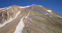
Redcloud Peak - Northeast Ridge Standard Route
Difficulty: Class 2
Total Elevation Gain: 3,700'
Round-trip Distance: 9 mi
Exposure: Moderate
Rockfall Potential: Moderate
Route-Finding: Low
Commitment: Low
route
Sunshine Peak - Via Redcloud Peak Standard Route
Difficulty: Class 2
Total Elevation Gain: 4,800'
Round-trip Distance: 12.25 mi
Exposure: Moderate
Rockfall Potential: Moderate
Route-Finding: Low
Commitment: Considerable
route
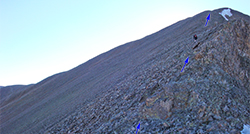
Sunshine Peak - Northwest Face
Difficulty: Difficult Class 2
Total Elevation Gain: 3,800'
Round-trip Distance: 8.5 mi
Exposure: Moderate
Rockfall Potential: Considerable
Route-Finding: Considerable
Commitment: Moderate
route
Sunshine Peak - East Ridge
Difficulty: Class 2
Total Elevation Gain: 4,600'
Round-trip Distance: 7 mi
Exposure: Moderate
Rockfall Potential: Considerable
Route-Finding: Considerable
Commitment: Moderate

Map

Human Verification Required

Trip Reports

  8 Recent Reports Peaks Climbed Added
  Redcloud & Sunshine Peaks
By: RMcGee
Added: 8/10/2026
Redcloud Peak
Sunshine Peak
8/8/2026 8/10/2026   4
  Sunny, hot day on Redcloud and Sunshine
By: Paul M
Added: 8/9/2026
Redcloud Peak
Sunshine Peak
8/5/2026 8/9/2026 4  39
  Quest to 100 / Part 4: Late Summer Deception and I Cannot Read Metric / #53 to #69 Google Map Included GPX file available for download
By: notidealbutfine
Added: 12/15/2025
Grizzly Peak
Mt. Hope
Uncompahgre Peak
Wetterhorn Peak
Cronin Peak
"Phoenix Peak"
Redcloud Peak
Handies Peak
Little Bear Peak
Mt. Lindsey
Mt. Oklahoma
Blanca Peak
Ellingwood Point
Sunshine Peak
Unnamed 13838
8/31/2025 12/15/2025 5  14
  Baring my Soles in the San Juans
By: Mountain Ninja
Added: 7/18/2025
Wetterhorn Peak
Redcloud Peak
Sunshine Peak
7/9/2025 7/18/2025 7  36
  A Bloody Dramatic Season Finale
By: HikesInGeologicTime
Added: 9/16/2024
San Luis Peak
Humboldt Peak
Redcloud Peak
Sunshine Peak
Handies Peak
7/9/2019 9/16/2024 3  2
  Long Hot Day & Made the call to 911 for Help
By: calebtk
Added: 7/29/2024
Redcloud Peak
Sunshine Peak
7/27/2024 7/29/2024 6  10
  Short and Simple - Sunshine and Redcloud
By: vswrman
Added: 7/9/2024
Redcloud Peak
Sunshine Peak
7/6/2024 7/9/2024 1  6
  Redcloud-Sunshine-Handies Day 1, Princeton Day 2
By: dwd1985
Added: 7/3/2024
Redcloud Peak
Sunshine Peak
Handies Peak
Mt. Princeton
6/25/2024 7/3/2024 2  7
View All 194 Trip Reports

Frequently Asked Questions about Sunshine Peak

What is the safest and most practical route to choose when climbing Sunshine Peak?

The easiest and safest method is to combine it with its neighbor by taking the standard Sunshine Peak via Redcloud Peak route. Even though returning requires you to re-climb a few hundred vertical feet back over Redcloud's summit, you should choose this option. Attempting to shortcut your way back down by dropping directly off the Redcloud-Sunshine saddle into the tempting northwest face gullies will funnel you into incredibly loose, hazardous scree and impassable cliffs.

Was Sunshine Peak ever in danger of being demoted to a 13er ranking?

Yes, Sunshine Peak has historically been a source of extreme curiosity within the climbing community because it traditionally held the title of Colorado's lowest 14er. When recent LiDAR studies were conducted to re-evaluate the state's 14er summit elevations, some feared preliminary data would drop Sunshine Peak below the magical 14,000-foot threshold. However, the findings actually saved its status by re-measuring Sunshine up to 14,004 feet.

Can I camp directly at the Silver Creek Trailhead before my climb?

Yes, there is limited dispersed camping available directly around the main trailhead area and farther up the road, but spaces fill up very quickly during prime summer weekends. Just remember that because this basin sits inside a highly sensitive high-alpine watershed, you must pack out all of your trash and strictly adhere to seasonal campfire restrictions. You might also consider the developed campgrounds (Mill Creek Campground or the Williams Creek Campground) lower on the road.

Can I hike Sunshine Peak in the spring when the main seasonal access roads are closed?

Yes, you can successfully summit the peak during the spring road closure by utilizing the rugged Sunshine Peak East Ridge route. This alternative approach begins right near the Mill Creek campground entrance, bypassing the closed, snow-packed road sections leading to the main Silver Creek Trailhead. Keep in mind that this is a highly demanding, off-trail mountaineering effort where the first 2,500 vertical feet force you up a punishingly steep, rugged forest slope before you gain the defined ridge line.

Additional Sunshine Peak History

Name History 1
Climbing History 0
Mining 0
Geology 0
More Information 0
  View All