| Report Type | Full |
| Peak(s) |
Grizzly Peak - 13,997 feet Mt. Hope - 13,939 feet Uncompahgre Peak - 14,318 feet Wetterhorn Peak - 14,021 feet Cronin Peak - 13,872 feet "Phoenix Peak" - 13,904 feet Redcloud Peak - 14,037 feet Handies Peak - 14,058 feet Little Bear Peak - 14,041 feet Mt. Lindsey - 14,055 feet Mt. Oklahoma - 13,843 feet Blanca Peak - 14,350 feet Ellingwood Point - 14,057 feet Sunshine Peak - 14,004 feet Unnamed 13838 - 13,838 feet |
| Date Posted | 12/15/2025 |
| Date Climbed | 08/31/2025 |
| Author | notidealbutfine |
| Quest to 100 / Part 4: Late Summer Deception and I Cannot Read Metric / #53 to #69 |
|---|
|
From my blog: https://notidealbutfine.wordpress.com/ 
Welcome back for another chapter of the Quest to 100: my climbing journal of my journey through the Colorado Centennials. Chapter 4 begins in late summer at Labor Day weekend and ends just before Thanksgiving. Generally I’ve been dividing the chapters into seasonal conditions and, to my surprise, the summer climbing conditions this year lasted well into November. Despite an early season snow the second weekend of September, the state didn’t see a big storm again until around Thanksgiving, greatly extending the dry climbing conditions for the one of the longest fall seasons I have ever experienced living here. Chapter 4 begins with climbing some chill peaks in anticipation of the Little Bear-Blanca Traverse, the first snow of the season cancelling said traverse, an unplanned, month long break in October, and ending with a redemption arc late in the season for some much needed 5th class revenge in the Sangres. Join me again at the end of this article for some closing thoughts on the season as the long dark of winter encroaches… Thanks again for joining me along the Quest! Have fun and stay safe in the mountains! My CalTopo Map: https://caltopo.com/m/KS1MKP5 8/31/25 “The Definitive Sawatch 14er Experience Sans Crowds (and 14ers)” 
My main objective this Labor Day weekend was to climb some peaks away from the holiday crowds. Obviously, this meant staying away from the 14ers and any 13ers that share trailheads. After looking over my map, I figured having an easy weekend in the Sawatch might be nice before the upcoming Little Bear-Blanca Traverse so I ended up landing on the Grizzly/Garfield combo plus Mount Hope the following day. I managed to make it all the way to the McNasser Gulch trailhead Saturday evening without too many troubles and settled in for a quiet night. Sunday morning I decided to be lazy and sleep in since the weather was looking good and the mileage was short. The trail follows an old mining road for about 1.5 miles before petering out, then ascends the south face of Grizzly’s east ridge. The route looked tough but it was quite easy to keep it within class 2 to my surprise. Once upon the saddle, I stayed on the ridge crest for some fun class 3 scrambling over the various bumps on the ridge. Grizzly’s summit had some wonderful panoramic views, especially of the nearby Elks. The traverse to Garfield felt longer than expected and went at class 2, as you could walk around most of the big features. I took a long, tranquil break on Garfield’s summit before some fun scree surfing on the descent back to the basin. Truly amazing to have the trail to myself on a holiday weekend. 9/1/25 “Colorado Trail Nostalgia” 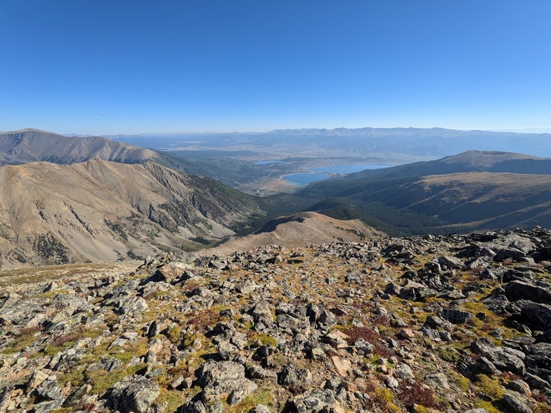
After finishing up Grizzly, I headed down to BV for lunch, only to get accidently served chicken in my vegetarian biryani. Bummer. I hung around town and got some errands done before heading north onto the very familiar CR 390 to camp near the Sheep Gulch trailhead. I’ve been up this road a lot this season and I’ll back once more for Emerald! To my surprise, I found a secluded campsite about a half mile away from the trailhead. I’m knocking it out of the park this Labor Day weekend! I decided to sleep in again due to short mileage and good weather and got started on trail around 7:30AM. Hiking up Hope Pass brought back all of the memories of this place when I was hiking this section of the Colorado Trail, particularly climbing the other side of the pass. If my memory serves me correctly, I remember about 4,000′ gain over roughly 4 miles. It absolutely toasted me since, for some reason, I decided to hike it at the end of my already long day. Alas, today would also be a 4,000′ gain day, but decidedly easier without the big backpack. The trail ascends switchbacks up an Aspen forest for the first mile or so below tree line. At one point, I followed a grouse on trail for almost a quarter mile; one of my most amusing and peculiar wildlife experiences so far this year. I chatted with a few thru hikers on the saddle, but had Hope’s east ridge all to myself. You can pretty much hike this one on the south side of the ridge, but I decided to spice it up with some class 3 fun where I could by staying high on the ridge. Before long I had made it to Hope’s massive summit. Oh so familiar views of Twin Lakes tug on my heart strings as always; this place always gets me in the feels for some reason. Overall, it was beautiful to have a chill weekend out in the Sawatch. It makes me think that Fall is going to be wonderful out here. 9/7/25 “Cloudy Vibes Accompany the First Snow of the Season” 
William and I have had the Little Bear-Blanca Traverse on the books since we climbed Bells back in late June. Unfortunately for us, the first snow of the season happened to occur the day before we planned the climb. This seems to happen to us a lot… Alas, after some state-wide weather evaluation, we settled on Uncompahgre Peak because of its easy class 2 route. I’d plan to stay an extra day to climb Wetterhorn Peak as well. I set off for the Nellie Creek trailhead Saturday afternoon around 2:30PM. After Lake City and a few miles up the Henson Creek road, I met William at the base of the 4WD road. Stupidly, I decided to give the road a try in my Element since I was excited about testing out my new sleeping setup. To my surprise, I actually made it up to the trailhead, but the going was extremely slow and was by far the toughest trail I’ve driven this season. We got started around 5:00AM the next morning and made super quick progress up the trail. The Nellie Creek trailhead is at ~11,000′ elevation so there wasn’t a lot of forest hiking on this one, though the alpine tundra on Uncompahgre is incredibly unique, featuring a lot more grass than rocks. As it was getting light, we made it to the base of the south ridge. Above 13,000′, we were completely shrouded in the clouds making for an amazing snowy vibe, despite the lack of views. The climbing/hiking was generally nice and mild, but the fresh snow and whiteout conditions added some extra spice and fun. Once off the ridge, we had a fantastically cool run back down and were back at the trailhead by 9:30AM. Nice to have an early day in the clouds and beat the crowds. 9/8/25 “Didn’t It Snow Yesterday?” 
After finishing Uncompahgre around 9:30AM, I had the half-baked idea to drive to the Matterhorn Creek trailhead and attempt Wetterhorn in the same day. It took me quite a while to drive down the Nellie Creek 4WD road and accidentally drove all the way back to Lake City before realizing I needed to to back up the road 11 miles to where I was going. Study your maps, kiddos! By the time I got up the rough North Henson Creek road to the 2WD trailhead, it was almost noon and storms were rolling in so I decided to chill and stay in my new camping setup in the car for a fantastic slow afternoon: just what I needed. I started the next morning at 6:00AM and was feeling oddly motivated to give it all I had today and move fast. This kind of motivation ebbs and flows for me so I try to take advantage of it when I can! The trail was generally uneventful in the dark until you reach the basin above tree line. From there, the views and glory of Matterhorn and Wetterhorn really open up in an incredible way. The basin below the mountains is vast and hilly and the traverse between the two is truly grand. If I were better prepared, I definitely should have planned on it! Above the basin, the trail snakes through a boulder field before switch backing to the saddle. From here, the climb got fun and interesting: fantastic class 3 scrambling along the ridge all the way to the summit! I particularly remember the splendid rock quality and easy route finding, despite the climb being quite short. I was thinking the recent snow would spice this route up a bit, but it had pretty much completely melted by the time I was climbing the following day. I didn’t stay long on summit and ran down once I hit the saddle. The run bug really got me today and I couldn’t be happier with my sub 3.5 hour time! Unfortunately, I had some suspension issues with my car on the way out of Lake City and had to leave my baby to be repaired, leaving me sad and frustrated about my beloved ride. I definitely over-drove it and that’ll be a serious learning point for my future adventures with it. Life moves on! 9/21/25 “Like Antero, but Better” 
After a couple of weeks off due to car issues and bad weather, I finally mustered up the motivation to get out into the mountains again. Funny how feeling down is so cyclical: I don’t have my ride so I feel down and don’t go hiking, and it compounds and compounds. Though I already knew this, time in the mountains is therapeutic and it was so ridiculously salient to me until I spent a few weeks being lazy. I realize I am a person who thrives on challenge and effort. Laziness has its place, but is a trap that anyone can easily fall into. I packed up the Yaris with my car camping and hiking gear and set out for the Baldwin Gulch trailhead Sunday afternoon around 2:00PM. I ended up choosing Cronin Peak due to the ease of trailhead access; this little 2WD vehicle can’t do much but there are certainly a handful of trails I can still access while the Element is in the shop. I camped at the Grizzly Gulch trailhead just like when I had climbed Antero due to there being a bathroom here. Unlike last time, my camp was pretty busy and loud right next to the road but it quieted down around 9:00PM and I ended up getting a nice sleep before starting around 5:15AM the next morning. I hiked about 3 miles in the dark along the Antero road before leaving the trail and bushwhacking a half mile to the base of the saddle where I encountered a herd of about 2 dozen mountain goats sunning themselves on the south face. I kept my distance I decided to gain the saddle further down the basin, closer to the “new” route up Cronin. To my surprise, there was very little snow on the east facing slope to the saddle. Additionally, any snow on the saddle was mostly blown off making for a nice class 2 romp up the ridge to the summit. I had a nice long break on top to really absorb the beauty of the ephemeral Fall colors all around. It’s truly a lovely time of year to be in the mountains and I’m happy to be back in the swing of things. 10/6/25 “Pure, Unadulterated Birthday Solitude on Colorado’s Lowest Traffic Centennial” 
Originally, I had planned to hike Rio Grande Pyramid this birthday weekend of mine. Conditions were looking decent and I had heard the trailhead was 2WD accessible, which was good because all I had was the Yaris again this weekend. Just past Creede, I noticed my map say “Unpaved for 14 miles” which I certainly did not want to do in this little car, so I turned around back for Creede and pivoted to climb Phoenix Peak, my last La Garita Wilderness Centennial. The road was also 2WD dirt but only 3 miles instead of 14. There was just one big rut about 100′ below the trailhead but I managed to make it in the dinky car for a quiet night in the woods. I rolled out at 5:00AM on the coldest morning of the season so far. I had all my winter layers on and I was still pretty chilly. I hiked in the dark along FR 502 1A for about a mile before leaving trail and crossing the creek which ended up being the crux of the day. It was severely dammed (damn beavers!) so there was a large bog emanating about 30 feet from the creek, which I inevitably got both of my feet soaked in, making a cold morning even colder! Beyond the creek crossing, the off trail travel wasn’t too bad, just a lot of gain. Just as I left tree line and crested a bump, I got a great surprise look at about a dozen elk, including one big male, grazing atop the crest. Eventually they scared off and two groups were bugling to each other from opposite sides of the ridge with me in between: what a serene, irreplicable moment! The climb up the south slopes reminded me of Mount Massive; just a long slog up a face. Once on the summit ridge, it appeared to be much longer to the summit then I had anticipated but the going went pretty quick and before long I was atop Phoenix Peak, peering down upon the nostalgic Machin Basin where I had spent a lot of time last summer. I love coming back to these places and seeing them from a new angle; it’s truly one of my favorite parts about this project! Excellent views of Rio Grande Pyramid and San Luis from here as well as fantastic fall colors and true isolation. Phoenix is honestly more of a two star route, but the serious lack of crowds really helped elevate this one for me. I couldn’t have asked for a better birthday present! 11/2/25 “A Post-Snow Second Wind and Four for the Price of One” 
Since my birthday weekend about a month ago, the weather had been pretty crappy for climbing even though we hadn’t gotten a big snow since early September, making for one of the longest fall seasons I’ve ever experienced in Colorado. Weirdly, now that it is November a good window has popped up. With low winds and no storms in the San Juans, I decided to get out to Lake City and hopefully knock out as much as I can before CR 30 closes for the season. I drove out to the Silver Creek/Grizzly Gulch trailhead Saturday evening in my newly repaired Element and enjoyed a beautiful car camp in a bigger ride. Nice to have bathrooms at the trailhead too! The next morning I hiked for about 2.5 hours in the dark up to the basin following Silver Creek. The upper basin is extremely open and beautiful this time of year with the stark difference of snow on the various aspects. The trail was dry up until the north facing climb to the saddle which ended up not being too bad early in the morning due to bullet hard snow. I made it to the saddle around sunrise then headed up Redcloud. The class 2 climb had patches of snow here and there but nothing spikes, poles and trail runners couldn’t handle. It seems I picked the perfect kit today; I was contemplating boots but am glad I didn’t go for them! I summited Recdloud around 7:30AM then followed the ridge to Sunshine for a quick out and back early in the morning glow. It was barely 9:00AM by the time I had gotten back to the saddle so I contemplated my next move: do I go for the two unnamed Centennials while I’m up here? The weather was good, I had plenty of food, it was early and I was feeling good. With all signs pointing to yes, I buckled in for another 5 miles and 3k gain to bag the two additional peaks in the group, making for one of my biggest days in the mountains this season. Most of the ridge walking to the final two summits was south facing making the hiking quick and pleasant. Nice to get out for a long day in one of my favorite places in the state and excited for Half Peak tomorrow! 11/3/25 “Late Season Terror: Kicking Steps with Trail Runners” 
After my day on Redcloud, I came back to camp, had dinner and settled in for the night. I originally had planned to hike Half Peak, but realized I didn’t have any of the beta downloaded on my phone so I decided to pivot to Handies’ east slopes since I was already camped at the trailhead and had the beta downloaded. I got started around 4:30AM on the Grizzly Gulch trail which was in truly excellent condition; hiking on the log steps was almost like stairs! Views of Handies in the sunrise light on the approach were truly amazing: Handies is huge and beautiful and the eastern approach certainly did not disappoint. I moved pretty fast on the well defined trail until just above tree line where I hit the first signs of snow. Stubbornly, I stuck to the defined trail despite the knee high post holing. After about a half mile of suffering, I improvised and met up with the saddle between Wilderness Mountain and Handies early and walked the rest of the way to the base of the north ridge on nice consolidated snow. Climbing in fall is very unique with the attention to aspects and unconsolidated snow on the approaches and higher elevations. The last 500′ to the summit were honestly pretty hairy given my gear for the day: spikes, poles and running shoes, just like yesterday. Let’s just say when you’re kicking steps with your trail runners, you know you may have underestimated the terrain a bit! It certainly would have been no problems with crampons and an axe, but alas, I made the summit around 8:15AM soaking up the incredible views of the ridges coming off Handies, Sloan Lake and surrounding panoramas. Handies and the eastern San Juans are real gems, don’t listen to the haters. I managed to make it down very slowly and took a wide route to stay on mostly dry terrain to make it back to the car by 10:00AM. Today ended up being way more scary and full on than anticipated but luckily it all ended well due to some slow and methodical climbing. On that note, it’s certainly time to change up the kit for the season: winter is almost here… 11/9/25 “The Sangre Redemption Arc: a Definitive 10/10 on the Brown-Pants-Index” 
To my embarrassing dismay, it turns out that the metrics for my Mountain Forecast account (the primary website I use for reading the weather in the mountains) were switched to default, which ended up being Celsius instead of Fahrenheit and kilometers per hour instead of miles per hour. As a result, I’ve been mistakenly thinking it was far colder and windier than it actually was for the majority of the month of October, leading to me being cooped up at home most weekends. Oops! This was a pretty big blunder, but if that was the biggest fumble of the season so far, I’ll take it! The long hiatus had me restless to get on something else big and committing before the snow would start falling for real this time and that had me motivated and prepared for an adventure. I saw a trip report for the Little Bear-Blanca Traverse from 10/19 and it looked great still. Since I live to close to the Sangres, I could visually confirm that no new snow had accumulated since September so I decided to go for it as one last hurrah of the season on 5th class rock. I camped at ~8,000′ on Lake Como road Saturday evening and got started the next morning around 4:15AM. Even though this approach is crazy long without a 4×4 vehicle, the 5 miles to the lake in the dark went by pretty quickly. I truly cannot believe that people drive this road though: it is absolutely, beyond-your-wildest dreams, balling-bustingly insane. The major “Jaws” obstacles honestly looked impossible in any vehicle, but apparently people do it and good on them. This was another advantage to hitting Lake Como so late in the season: no sucking gas on the way to the lake. Just past Lake Como the trail climbs a gully to the top of the west ridge. From here, I followed the west ridge directly to the summit as opposed to taking the standard route (hourglass) or the new West Ridge Indirect route. The hourglass is known for its dangerous rockfall and was iced up like crazy anyway. West Ridge Indirect seems like a good route, but the rock was stable, the weather was good and I knew the cruxes on the direct route go at 5.4, which is perfectly reasonable for me to solo. I remember a pretty vertical chimney crux with a chockstone on top as well as a solid but exposed slab crux about a pitch above. The chimney felt steep but very manageable due to big holds but had some serious exposure on the thin ridge. Overall, it’s truly a pleasure to be climbing this super solid Sangre rock again, it’d been too long. By 10:00AM, I managed to summit Little Bear and was left with the big decision of the day: do I send it for the traverse today or play it safe and come back tomorrow for Blanca? This is certainly becoming a familiar headspace… I tried to do what I could and look at the variables with an honest and objective eye. It was still early, I had plenty of food, I was feeling good, and the forecast was looking decent despite the higher than expected winds. There wasn’t much risk of a thunderstorm today, but the winds were certainly higher than I wanted for this traverse (roughly gusts of 25 mph), as some of the thin sections narrow to less than a foot with gross exposure on both sides. Things were looking mostly good and I decided that if I go slow and stay methodical on the traverse it would go smoothly. With much anticipation, I gazed down the initial downclimb off Little Bear, locked it in, and began the mile long traverse between these two behemoth 14ers. Descending Little Bear was actually some of the most frightening and exposed climbing of the entire traverse. The rock quality was generally good, but the first downclimb still hung onto some snow that needed to be negotiated with precision. After the first section, the traverse levels off for a bit and thins before the Captain Bivwacko tower which is one of the more exposed sections of climbing. I traversed the narrow ledge around the left side of the tower and continued on to the highway, which was a huge relief as you drop down below the ridge crest for some time on the east side and are shielded from the prominent west winds. After tower 1, the climbing over towers 2 and 3 and finally the last pitch to the summit seemed much easier than any of the cruxes on the west ridge direct up Little Bear. I think this was a great way to trick my brain for the traverse even though the wind still made the climbing pretty terrifying. From the summit of Blanca, I took a short break to revel in the glory of finishing my second of the great traverse before setting off for Ellingwood. Ellingwood wasn’t originally in the books today, but the traverse from Blanca is so close and the approach to Lake Como is so long, I really didn’t want to have to come back up here again if I was already to close. I would have taken time to enjoy my victory on Blanca for a little longer, but it was already noon and I had to remember that November days are short and the hike back to the car was going to be a long one so I made a mad dash up Ellingwood’s south slopes and summited around 1:00PM. From here, I finally took a nice long break and really took in the immense views of the Spanish Peaks, Blanca, Little Bear, and the big traverse I had just completed. I was feeling extremely accomplished (and exhausted) as this was my biggest day of the season so far and a serious milestone for my climbing career but I knew I also needed to get down: the sun would set in about 3.5 hours and I had a long way to get down. Luckily, I was blessed with an uneventful descent back to the lake and made it back to the car just as the sun was setting. I’m feeling blessed that there was a little window on this traverse so late into the season and that I managed to get up and down. Between climbing the West Ridge Direct, the Little Bear-Blanca Traverse and finally hitting Ellingwood to finish off the day, I certainly couldn’t have asked for a better way to finish off the dry season. Though, with some hope and a dream, maybe, just maybe the Sangres will stay in for just a bit longer before the snow… 11/15/25 “Puckering through Icy Terrain” 
With the first big snow in the forecast for Sunday night, I wanted to get on something more technical before the weather hit and limited my options significantly for the next few months. After my success in the Sangres last weekend, I decided to go for Lindsey and Huerfano to finish out this range so I drove out to the upper Lily Lake trailhead Saturday evening in the Element to set myself up. The road was rough and slow, but not nearly as bad as some of the trails around Lake City. I had the trailhead to myself, tucked in for a cozy night and got started the following morning around 5:30AM. The Lily Lake trail was a little difficult to follow in the dark but once the sun came up it got a lot easier. The trail follows the creek through the forest before dropping a few hundred feet into the basin below Lindsey and Iron Nipple. Truly amazing views of Blanca’s north face from here. I climbed to the saddle then decided to go for Huerfano first since Lindsey’s northwest ridge was still mostly in morning shade. I bypassed Iron Nipple on the way over then headed up the generally boring south slopes to Huerfano. Despite the uneventful climbing, the views of Lindsey and Blanca from Huerfano were super memorable. On my way back, I tagged Iron Nipple and made it to the base of Lindsey’s northwest ridge before long. The ridge was mostly still in shade, but I decided to go for it. To my surprise, the route was much more sketchy than anticipated due to the rocks being icy. It seems like the dew had frozen from the previous day and was sticking to the rocks on an extremely thin layer making for some very slippery climbing. Spikes helped a lot especially when climbing the 4th class crux section and before long I had made it to the top of Northwest Lindsey with just a short class 2 romp to go. The climbing on Lindsey was generally good, but pretty short making for a quick day up and down. My descent down the ridge went smoothly as the sun was beginning to peak out and melt the remaining ice. I was treated to an encounter with a herd of about a dozen bighorn sheep on the run down making for a beautiful cap on an amazing day to finish off the “dry” season. With big snow in the forecast tonight, it’ll be mostly class 2 climbing for the next few months as I rest and recover. 11/23/25 “Mount Massive Feels, but Better” 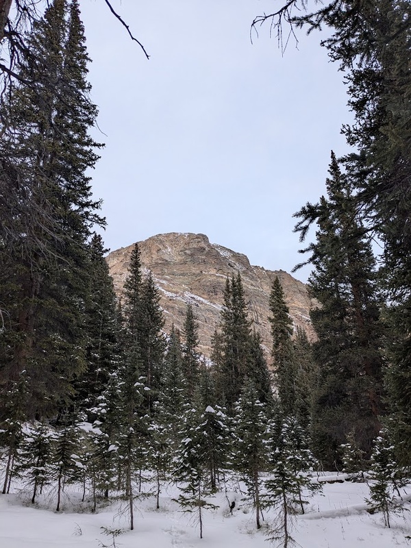
The plan this weekend was to get two days of climbing in before Thanksgiving because I’d be traveling to see family the following weekend. With new snow from a few days ago still fresh, I decided to go for something chill and class 2. As always, this was the perfect job for the Sawatch! I ended up landing on French/Casco and Oklahoma since they shared a trailhead. I drove out to the Mount Massive trailhead Saturday evening and had a weirdly eventful night helping some hikers who had gotten separated from their party after climbing Massive. Luckily, the separated climbers made it back to the parking lot around 10:00PM and I managed to get a great night of sleep before overhearing one of the best lines I’ve heard all season:
I got started around 4:30AM Sunday morning and followed the very familiar road up to the North Halfmoon trailhead. I probably could have driven the road, but I decided to hike the approach since Oklahoma would be a short day anyway. There was snow for a good three miles before the trailhead but I managed to keep trail runners on until I left tree line. From there, I’m glad I brought mountaineering boots and gaiters for the off trailing romping in the snow to the upper basin below Mount Oklahoma. From here, I could see the rest of the route was dry so I ditched my pack and just took the essentials: a bar, my inReach, spikes, poles and phone. The climb felt a little uneventful and oddly just like Mount Massive: a snow covered talus grind for roughly 1,500′. Just as I summited, the weather began to roll in and turn for the worse making for one of my closer calls of the season thus far. I had seen snow in the forecast, but only about an inch expected in the evening. Looked like the weather was going to be wrong so I booked it down to the basin and beat the snowfall by about a half hour and had a beautiful descent in a storm back to the car. Upon my arrival, the storm looked like it was going to be far worse than expected so I packed up my things and headed home, which ended up being a great idea. The storm ended up dumping way more than expected and I was happy to be back home and not driving the roads the day after the dump. No French/Casco tomorrow! Here’s to a good run before winter! 
Speaking of winter… It has finally arrived in all of its glory! The day after arriving back from my Thanksgiving trip to New England, Colorado got bombed with a few good consecutive storms over the following weeks, forming a solid snowpack that will serve as the base for the next few months. In the winter months trailheads close down, the days grow short, avalanches risk increases, and conditions grow more and more difficult to trudge through. Upon studying my list of 31 peaks remaining, I had to be realistic about what I was willing to give effort to this winter season so I narrowed down my list of peaks that wouldn’t feature either ridiculously long winter camping expeditions or extraneously difficult routes. This meant saving quite a few of the peaks in the San Juans including the Chicago Basin, the Grenadiers, the Wilsons, Rio Grange Pyramid, as well as Longs/Meeker, Holy Cross/Ridge, Snowmass/Hagerman, and a few others for next spring/summer. Of the few peaks that would remain, I’ve narrowed down my winter list to:
Emerald has a pretty far winter closure making it a long but doable 21 mile day. I’d preferably like to ski Buckskin in the spring when the getting is good instead of climbing it in winter with snowshoes. That pretty much leaves Columbia as the best option for a super safe winter ascent with its southeast ridge route. The realistic goal is to tackle between one and three of these peaks this calendar winter putting me between #70 – #72 for my one year anniversary of the Quest next spring equinox. The new (surprisingly quite realistic) goal for next season is to finish out the Quest before my next birthday, leaving me with roughly 30 peaks to climb between late March (when the skiing starts getting good) and early October. After finishing out 57 centennials this season (with an additional 19 summits along the way for a season total of 76), I’m feeling confident about the 30 for next season, especially since quite a few of the remaining are quite clustered together. Overall, I’m especially stoked for the Chicago Basin, Jagged Peak, the Wham Ridge, and generally just to ski as much as I can next season. Until then, I’ll spend the majority of my winter ski touring and ice climbing before the snow solidifies in late March to get back into the Quest. But wait… this is where the drama only begins! As of the summer of 2025, Crestone Peak was de-ranked in favor of its roughly 3.5 inch taller, previously subsummit, East Crestone. Luckily, I’ve already climbed all the Crestone Peak subsummits, but it turns out Columbia Point was also de-ranked in the process, apparently not featuring enough prominence from Kit Carson: I call it the Challenger Effect. Additionally, the roughly lowest 8 centennials are all in contention for spots on the list with this new technology. Surprisingly, this doesn’t affect my plans too much since I have already bagged Columbia Point and Obstruction Peak and was planning to get Jones, Niagara, and American together as well as Trinity. This pretty much just leaves Dallas and Teakettle, which were actually on the previous edition of the centennials list anyway. Both of these San Juan peaks feature rad 5th class routes that I wasn’t originally planning on getting, but I think I’d certainly like to make the time for. For all intents and purposes, the Quest to 100 will actually look something more like the Quest to 108, mostly because I just love being in the mountains but also for some minor insurance purposes. I can absolutely understand the merit in climbing a traditional list, especially since the way in which we rank peaks in Colorado is totally arbitrary, but will plan on bagging the 108 mostly out of convenience and curiosity to continue exploring. Personally, I like Washington state’s ethos on climbing lists: don’t take peaks off the list, just add more! And there we have it: 69 down, 31 more to go! Things will be a little quiet over here for the next few months as I hibernate from mountaineering for the winter, but I hope to send an update sometime this season with a success on one of my peaks before long. Until then, I wish you the best and thanks for reading! Here’s to the best of new years in 2026! 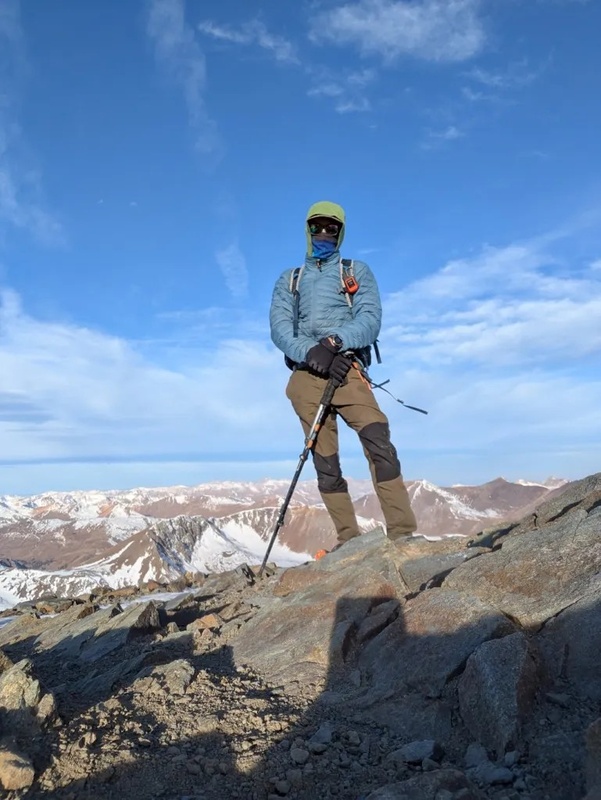
Thumbnails for uploaded photos (click to open slideshow):  Grizzly Ridge")
 Atop Hope")
 First Snow on Uncompahgre")
 Matterhorn/Wetterhorn")
 Antero from Cronin")
 Summit of Phoenix")
 Redcloud")
 Handies")
 Little Bear-Blanca Traverse")
 Blanca North Face")
 Mount Oklahoma")
 Handies North Ridge")
 Autumn is About Aspect")
 Windchill in the San Juans")
|
| Comments or Questions |
|---|
|
|
Caution: The information contained in this report may not be accurate and should not be the only resource used in preparation for your climb. Failure to have the necessary experience, physical conditioning, supplies or equipment can result in injury or death. 14ers.com and the author(s) of this report provide no warranties, either express or implied, that the information provided is accurate or reliable. By using the information provided, you agree to indemnify and hold harmless 14ers.com and the report author(s) with respect to any claims and demands against them, including any attorney fees and expenses. Please read the 14ers.com Safety and Disclaimer pages for more information.
Please respect private property: 14ers.com supports the rights of private landowners to determine how and by whom their land will be used. In Colorado, it is your responsibility to determine if land is private and to obtain the appropriate permission before entering the property.

