Log In 
Elevation 14,037' (LiDAR)
Prev Elevation 14,034'
CO 14er Rank 45 of 53
Range San Juan
County Hinsdale
Towns Ouray, Lake City, Silverton, Telluride
Redcloud Peak

Other 14ers in Group

Peak Sunshine Peak

Photos

360 Pano
360° Summit Pano
pic1
pic2
pic3
pic4
pic5
pic6 pic7 pic8 pic9 pic10 pic11 pic12 pic13 pic14 pic15 pic16 pic17

Climbing Routes

route
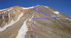
Redcloud Peak - Northeast Ridge Standard Route
Difficulty: Class 2
Total Elevation Gain: 3,700'
Round-trip Distance: 9 mi
Exposure: Moderate
Rockfall Potential: Moderate
Route-Finding: Low
Commitment: Low
route
Sunshine Peak - Via Redcloud Peak Standard Route
Difficulty: Class 2
Total Elevation Gain: 4,800'
Round-trip Distance: 12.25 mi
Exposure: Moderate
Rockfall Potential: Moderate
Route-Finding: Low
Commitment: Considerable
route
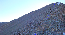
Sunshine Peak - Northwest Face
Difficulty: Difficult Class 2
Total Elevation Gain: 3,800'
Round-trip Distance: 8.5 mi
Exposure: Moderate
Rockfall Potential: Considerable
Route-Finding: Considerable
Commitment: Moderate
route
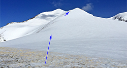
Sunshine Peak - East Ridge
Difficulty: Class 2
Total Elevation Gain: 4,600'
Round-trip Distance: 7 mi
Exposure: Moderate
Rockfall Potential: Considerable
Route-Finding: Considerable
Commitment: Moderate

Map

Human Verification Required

Trip Reports

  8 Recent Reports Peaks Climbed Added
  Redcloud & Sunshine Peaks
By: RMcGee
Added: 8/10/2026
Redcloud Peak
Sunshine Peak
8/8/2026 8/10/2026   4
  Sunny, hot day on Redcloud and Sunshine
By: Paul M
Added: 8/9/2026
Redcloud Peak
Sunshine Peak
8/5/2026 8/9/2026 4  39
  Kona The Mountain Dog
By: sfreytag
Added: 1/8/2026
Grays Peak
Torreys Peak
Kelso Mountain
Wildhorse Peak
Missouri Mountain
Uncompahgre Peak
Redcloud Peak
Mt. of the Holy Cross
Mt. Princeton
Mt. Columbia
Mt. Oxford
Mt. Massive
Mt. Cameron
Mt. Democrat
Mt. Yale
6/29/2019 1/8/2026 26  31
  Quest to 100 / Part 4: Late Summer Deception and I Cannot Read Metric / #53 to #69 Google Map Included GPX file available for download
By: notidealbutfine
Added: 12/15/2025
Grizzly Peak
Mt. Hope
Uncompahgre Peak
Wetterhorn Peak
Cronin Peak
"Phoenix Peak"
Redcloud Peak
Handies Peak
Little Bear Peak
Mt. Lindsey
Mt. Oklahoma
Blanca Peak
Ellingwood Point
Sunshine Peak
Unnamed 13838
8/31/2025 12/15/2025 5  14
  Baring my Soles in the San Juans
By: Mountain Ninja
Added: 7/18/2025
Wetterhorn Peak
Redcloud Peak
Sunshine Peak
7/9/2025 7/18/2025 7  36
  A Bloody Dramatic Season Finale
By: HikesInGeologicTime
Added: 9/16/2024
San Luis Peak
Humboldt Peak
Redcloud Peak
Sunshine Peak
Handies Peak
7/9/2019 9/16/2024 3  2
  Long Hot Day & Made the call to 911 for Help
By: calebtk
Added: 7/29/2024
Redcloud Peak
Sunshine Peak
7/27/2024 7/29/2024 6  10
  Short and Simple - Sunshine and Redcloud
By: vswrman
Added: 7/9/2024
Redcloud Peak
Sunshine Peak
7/6/2024 7/9/2024 1  6
View All 204 Trip Reports

Frequently Asked Questions about Redcloud Peak

How did Redcloud Peak get its name, and what is the history behind it?

The mountain was named for the striking, brilliant reddish-orange hue of its upper volcanic slopes, which glows intensely at sunset and gives the appearance of a fiery, low-lying cloud. The distinct coloration is caused by millions of years of intense hydrothermal alteration, a geological process where acidic volcanic fluids altered the minerals in the rock, turning them into soft, iron-rich clays that weather into vibrant shades of red, orange, and yellow.

Is Redcloud Peak considered a good starter mountain for the San Juan range?

Yes, Redcloud Peak is one of the best, safest, and most straightforward introductory 14ers in the entire San Juan Mountains. The standard route via Silver Creek follows an well-maintained trail that completely avoids complex route-finding and high-exposure cliffs, making it an ideal choice for hikers transitioning from mellow hiking trails to high-altitude peaks. However, if you want to get Sunshine Peak as well, this combination makes it more difficult and time-consuming, so you may want to hike Handies Peak instead if you're looking for the easiest 14er hike in the area.

Are porcupines and marmots a hazard at the trailhead, and how do I prevent vehicle damage?

Yes, the local critters at the Silver Creek/Grizzly Gulch trailhead frequently chew on brake lines, electrical wiring, and radiator hoses. They often do this at night or when you're off enjoying your hike. If you want to safeguard your vehicle you can wrap the entire perimeter of your car base with flexible, heavy-duty rolled rubber/plastic fencing anchored by rocks, or drive directly onto a large tarp and securely wrap the edges up and over your bumpers. Avoid using mothballs which poison the local alpine wildlife and really don't work well.

Can I climb Handies, Redcloud, and Sunshine all in a single day?

Yes, but it requires an incredibly long, grueling, and physically exhausting endurance effort because Handies sits in an entirely separate drainage across the valley. To combine all three, you must start extremely early to complete the standard Redcloud-to-Sunshine ridge loop first, return all the way down to the Grizzly Gulch / Silver Basin Trailhead, and then begin a second, independent 3,000-foot vertical climb up the East Slopes of Handies Peak before afternoon thunderstorms roll in.

Additional Redcloud Peak History

Name History 1
Climbing History 0
Mining 0
Geology 0
More Information 0
  View All