Download Agreement, Release, and Acknowledgement of Risk:
You (the person requesting this file download) fully understand mountain climbing ("Activity") involves risks and dangers of serious bodily injury, including permanent disability, paralysis, and death ("Risks") and you fully accept and assume all such risks and all responsibility for losses, costs, and damages you incur as a result of your participation in this Activity.
You acknowledge that information in the file you have chosen to download may not be accurate and may contain errors. You agree to assume all risks when using this information and agree to release and discharge 14ers.com, 14ers Inc. and the author(s) of such information (collectively, the "Released Parties").
You hereby discharge the Released Parties from all damages, actions, claims and liabilities of any nature, specifically including, but not limited to, damages, actions, claims and liabilities arising from or related to the negligence of the Released Parties. You further agree to indemnify, hold harmless and defend 14ers.com, 14ers Inc. and each of the other Released Parties from and against any loss, damage, liability and expense, including costs and attorney fees, incurred by 14ers.com, 14ers Inc. or any of the other Released Parties as a result of you using information provided on the 14ers.com or 14ers Inc. websites.
You have read this agreement, fully understand its terms and intend it to be a complete and unconditional release of all liability to the greatest extent allowed by law and agree that if any portion of this agreement is held to be invalid the balance, notwithstanding, shall continue in full force and effect.
By clicking "OK" you agree to these terms. If you DO NOT agree, click "Cancel"...
Maroon Peak - Unexpected Starry Night and Fortunate Outcome
Amy and I hiked Maroon Peak on Thursday 9/9/21. Our intent was to follow the standard South Ridge route out and back from the Maroon Lake trailhead. Given the dry, warm, and sunny forecast for several days that week and certain child care/work logistics, we decided to do the hike as an afternoon outing rather than the typical alpine start. We made the summit (#55/58 for us) and returned home safely, but spent an unexpected evening under the stars around 11,500' on Maroon's east slopes after losing the trail. We were fortunate to not have serious injuries. Our overdue return caused stress/anxiety on family and impacted other climbers on the mountain Friday. We thought it would be worthwhile to share our story to help others avoid similar situations and reinforce those lessons internally.
Summary RT Length - 12 miles (intended); estimated distance with meandering, searching, and backtracking: 18-20 miles Total Gain - 4,800 feet (intended); estimated gain with meandering, searching, and backtracking: 7,000-7,500 feet Hike Duration - Expected 12-14 hours; actual time 27 hours 42 minutes
Report The forecast for Sept 8-10 was warm, dry, limited/no cloud cover, and low winds. We had a midnight to midnight parking pass at Maroon Lake for Sept 9. We initially planned to leave Denver around 3:00am and start hiking after driving to Maroon Lake. Due to various child care related issues, we weren't able to leave Denver until after 8:30am Thursday morning. We debated doing a closer 13er instead, but decided to give Maroon a try after speaking with the Ranger's office and making arrangements to drive up the road in the middle of the day. Normally, passengers vehicles are prohibited during peak hours.
We packed quickly Thursday morning and made only one stop on the way to Maroon Lake, when we added more spare batteries to our supplies, arriving around 12:30pm. On the drive, we talked about descending in the dark. We discussed our safety nets: don’t wander off of safe terrain in the dark, back-track when you lose the route, etc., be prepared to spend the night on the mountain to wait for daylight. We set turnaround times for the Maroon Peak turnoff, the start of the South Ridge, and the summit. We believed that if we could make it past the 2,800' of suck before 5:00pm, we could make the summit before sunset (7:15pm) and descend the more difficult gullies and Class 3 sections in the lingering twilight. We had routes/maps loaded on Gaia GPS and the 14ers.com app as well as a spare phone charger to help with night time navigation. We had been planning this hike off and on for 5 years, so felt reasonably confident even though this type of afternoon hike was not normal for us.
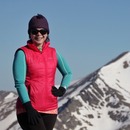
All smiles starting outStarting up the Suck
The hike started out really well. We passed turnoffs for Pyramid and North Maroon faster than we hit those marks on previous hikes. We split from the West Maroon Creek trail to gain that 2,800' with more than 2.5 hours to get to the ridge ahead of our turnaround time. We did not have any issues sticking to the trail on the way to the ridge. Sometimes our paces would naturally lead to a little bit of separation and we continued to stay on the trail independently. The route description suggests the trail is harder to follow as it gets higher. We did not find this to be the case on the way up.
About halfway up to the South RidgeSpoiler Alert - We unknowingly took a picture of a willow we'd later use for shelter that night. Here's Hotel Willow, 1/5 Stars, Do not recommend
We made it to the 13,250' spot on the ridge about 20 minutes ahead of our planned turnaround time. We took a minute to stow poles, put on helmets and refuel. From here, we expected more tedious route finding among the gullies and Class 3 sections. Overall, we thought this section of the mountain was enjoyable and not as difficult as North Maroon, Pyramid, or Capitol. The rock was reasonably solid when you needed it to be and the loose gullies could be mitigated to some extent by climbing along the sides. We opted for Gully #1 in the route description and climbed along the right side. We followed great cairns to transition to Gully #2 and continued on the ledge to the Robot Rock.
Chimney and large crack offers some of the initial Class 3 climbingStarting up Gully #1 along the right sideGreat cairns and Robot Rock landmarks to guide navigation day and night
The broad gulley separating Point 13,753' and the summit was more tedious than Gulley #1. Amy went up the left side and found an OK path. I stayed more in the center, following loose dirt/trail segments on the way up. After the broad gulley, we followed cairns up and around ledges to the summit. Our reward for a late afternoon hike was remarkable sunset scenery.
Sunset with Snowmass and CapitolNorth Maroon#55Lingering wildfire smoke combined with the sunsetStill some smiles as we gear up to head downThis is a face of uncertainty wondering if we'll regret descending in the dark
We stayed on the summit less than 10 minutes. With the sunset, we quickly noticed the twilight was not hanging around as long as we anticipated. It became clear we would not make it back to 13,250' with any daylight. Thankfully, there were lots of useful cairns and we were slow/methodical on the descent to make sure we stayed on route. Similar to the experience on the way up, the rock was solid where we needed it to be and the Class 3 sections weren't any more difficult in the dark. Our descent was slow, but smooth as we continued down the South Ridge.
Final sunset viewsFinal sunset views
By the time we got to the end of the South Ridge and ready to turn down the East Slopes from 12,900' (~9:00pm), it was completely dark. However, the weather was great and we were relieved to be out of the difficult sections. Countless stars filled the skies overhead. The descent down the 2,800 feet of suck isn't any better coming down. In fact, it's probably less fun. Navigating by headlamp and GPS meant our pace continued to be very slow. There are some cairns, but they were less frequent than what we saw along the ridge. We ran out of water around the time we turned off the ridge and headed down the slopes. We were not overly concerned because we knew we could get/treat water once we got down to 10,400'.
Sometime around 10:00pm and roughly 11,800', we lost the trail, as it appeared to abruptly end after an outcropping of rock that required some focused maneuvering. Though the trail had been unmistakable to that point, we could not see any evidence that it continued in the same direction or nearby. We backtracked to look for what we assumed must be a turn-off, and proceeded to spend the next three hours trying to “find the trail.” Initially, we descended what we later felt was likely a game trail for perhaps 100-200' along dirt segments, grassy tundra, etc. This area had some rock gullies and terrain that exceeded the Class 2 slopes we ascended. We decided to go back up to the last point we felt confident we were on the trail. GPS told us we were close to the trail, but sometimes it would say the trail was above us and sometimes below us (even when we might only move a few feet). We continued this pattern of finding the trail, getting slightly off to descend unfamiliar territory, and then going back up to find the trail. It was incredibly disorienting/maddening to go back and forth over the same area only to end up off trail each time. We were likely always within 100 feet of the actual trail, but simply could not locate it to continue our descent.
By 1:00am we decided our safest action would be to descend as low as we safely could to find the most protected area for an overnight bivy. We settled for a willow bush around 11,500'. We each had emergency stuff sacks in our packs. For me, it was a stuff sack I probably packed 5-10 years ago and had rarely checked to see what was in it. It's also the kind of thing you might raid from time to time and forget to restock. In mine, I had an emergency blanket, extra socks, thermal pants, and hand warmers. Amy had socks, extra gloves, a hat and thermals. Notably, Amy had removed her emergency blanket some time previously. Temperatures were likely in the low 40s so it wasn't life threatening, but it was certainly uncomfortable. We snuggled up on the slopes under the emergency blanket with our feet in the willows to make sure we didn't roll down the hill if we happened to doze off to sleep. No sleeping occurred.
Around 4:00am, we spotted a headlamp coming up the trail. We tried to yell down, but it wasn't clear if the other hiker (Ryan) could hear us. We set one of our headlamps to blink and kept it pointed in the general direction where we thought the trail to be. I watched the other hiker continue up the trail and eventually was able to communicate back and forth. We were probably 50 feet from the trail, but still could not see a path to safely get to the trail in the dark. We talked for a couple minutes and decided waiting for daylight was still the best option. We confirmed with Ryan that we weren't injured and it wouldn't make sense for him to try to hike any closer to us.
By 6:30am it was light enough to see our surroundings comfortably without a headlamp. We could see the trail down and to our right (facing north). We knew roughly where the other hiker had been up and to our right (facing uphill), but did not feel safe climbing to that area off trail. We hiked up to roughly 11,800' covering much of the same ground we walked up and down the previous night. We were on a trail, but the experience in the dark had shaken our confidence. We weren't convinced it was the actual trail. In fact, we decided none of looked like the 2800’ feet of suck we remembered ascending in the daylight the afternoon before. So, we continued up and up until going all the way back to 13,200'. We wondered if we had somehow left the ridge too early or gotten off route much higher than 11,800'.
Around 9:15am and resting at 13,200', we started getting text messages. We were finally able to let family know we were not injured, simply got lost on our descent. They had been in contact with Pitkin County Sheriffs office a couple hours earlier. We also exchange texts with Mountain Rescue Aspen (MRA). At the same time, three climbers were approaching us, a local guide (Jeff) and two clients. They intended to summit Maroon Peak and traverse to North Maroon. We had the normal hiker hellos, but they quickly realized we had spent the night unintentionally on the mountain and seemed in a foggy state. All three were incredibly kind and generous. After about 30 minutes, Jeff suggested that he help us descend to the area where we lost the trail while his clients wait at the start of the ridge. While it seemed like it should be very obvious where to go, we agreed that Jeff's plan was the safest action. This plan would also keep SAR and sheriffs resources out of the field. We left the ridge about 10:15am and descended with Jeff for a little over an hour. Amy and I are incredibly grateful for this group of hikers and hope to emulate their spirit on our future outings.
From that point on, it was simply a long, slow walk out. The sun was relentless, with few shaded spots. It felt like walking through a desert, even though temperatures were in the same range as the previous day. We're guessing our lack of water/dehydration made it more difficult to regulate our body temperatures. At around 10,500’ and 2:00pm, we had our first liquid in ~17 hours, beyond a few ounces of what our generous hiker/guide friends could spare. The stream water tasted like Fuji had missed a lucrative opportunity. Somehow in our delirium, we opted not to fill both bladders. Still wondering about that decision… About a mile from the trailhead, we encountered Ryan from the Pitkin County Sheriff's office. Ryan and MRA knew we were on our way day from our earlier correspondence around 10:00am. However, we would not get cell signal again until we made it to the car and several minutes down Maroon Creek Road. So, they were concerned that we had not yet responded to texts asking if we were down safe. Ryan had finished his shift, but didn't have a good feeling when he saw our car was still in the parking lot around 4:00pm. Ryan was excited to see us and radioed to let our family know we were nearing the trailhead. While chatting with Ryan at Maroon Lake, Jeff and his clients caught up to us as well. We were really disappointed to learn they decided not to continue their hike once Jeff returned to the ridge. It was painful knowing our mistake had caused them to miss out on a great opportunity to hike the traverse on a gorgeous day. We can't thank them enough, and we're really grateful for everyone that took such a vested interest in our safety throughout the ordeal.
We had some moments of levity when we were safely to our car, guzzling the liquids we had in our cooler. We were adamant that the temperature was in the 90s, only to discover that it was firmly 78 degrees (we checked multiple sources). We also confided in one another that each of us had independently determined that Ryan was a crazy dude dressed all in black carrying a gun in his hand but no backpack coming up the trail to kill someone. Amy said her impression left her feeling something like, “yep, that’s how this trip is going.” It turned out to be his radio. We later agreed that the excursion included the most unsuccessful successful summit of our careers, thus far. Ryan said it best: “Sometimes Mother Nature bites back to make us appreciate her.”
Glance back at the Bells nearing Maroon Lake
Takeaways
If planning to hike in the dark (either pre-dawn or post sunset), be aware of sun location and how shadows from surrounding terrain may impact visibility. We knew the sun would last longer on the South Ridge route because it was on the west side of the ridge. If the route had been on the other side, we would have been hiking up in near darkness. Ultimately, we still lost daylight quicker than we anticipated.
Be prepared to spend the night outside. I've heard others say this many times, but typically sort of brushed it off. While we were generally prepared for it, there was some dumb luck involved (like having hand warmers in my pack from a previous hike).
Check your emergency gear regularly and determine if it's enough for your intended hike. It had probably been at least 2-3 years since I had opened that sack. My emergency blanket was in decent shape, but Amy had moved hers to a different pack at some point.
Make sure someone knows where you're going and specifically the precise route information, expected return time, etc. This seems fairly obvious, but it's probably worth oversharing. The sheriff's office/SAR were very thorough in asking questions of our emergency contact. The more information he was able to convey (including comments on physical health, preparedness, etc.), the easier it is for them to decide what to do.
Don't give in to the temptation to continuing descending when you know you're off route. It can be very demoralizing to find yourself off trail and look back up that slope knowing the correct path is above you. Just go back up.
We've joked that it's difficult to explain this story. How do you explain losing the trail for several hours while being on the trail or within 50-100 feet of it (especially knowing we weren't dealing with snow, rain, fog, etc.)? Then the next morning, deciding to hike back up 1,700' or so because we convinced ourselves it wasn't the same trail we hiked the day before. The only conclusion we came up with is that your brain can get in a fog under strenuous physical activity and mental stress, compounded by darkness and no water. I suppose the best option is to avoid situations that would lead to that brain fog. If you find yourself there though, don't be afraid to slow down your decision making process and fall back on your safety nets.
Split Time (Duration) Maroon Lake TH - 12:46pm (0:00) Pyramid Turnoff - 1:22pm (0:36) North Maroon Turnoff - 1:40pm (0:54) Maroon Turnoff - 2:21pm (1:35) South Ridge after the 2,800' of suck - 4:40pm (3:54) Robot Rock - 5:55pm (5:09) Summit - 7:05pm (6:19) Water Empty - 9:00pm (8:14) Lost Trail on East Slopes - ~10:00pm Willow Bivy @~11,500 - ~1:00am Verbal Contact with another Hiker - ~4:00am Start Backtrack - 6:35am (17:49) Cell Signal near 13,250' - 9:14am (20:28) Conversation with Local Guide/Climbers - ~9:30am Texts with SAR - 9:49am (21:03) Begin Descent/Stand Down SAR - 10:15am (21:29) Water at West Maroon Creek Trail - 1:45pm (24:59) Maroon Lake TH - 4:28pm (27:42)
No crowds for sure, Wentzl. There was a party of 3 coming down the 2,800 as we were going up on Thur. I think those were the only people we saw beyond Crater Lake until Friday morning. There was the group of three that helped us Friday and one other group of 2-3 that passed just before we started down. Then no one until the West Maroon Creek trail. Given the perfect forecast, I was surprised we didn't see more people, but I suppose Thur and Fri still count as weekdays.
Porkrind, Amy is from AL and I'm from TN. I went to Georgia Tech for undergrad and lived in ATL for about 10 years. We've both been out here for a while now though. I see a fair bit of GA folks on the trail, not much GT paraphernalia though.
Thanks for reading and commenting E_A_Marcus and DeTour. It was a bit grueling and really frustrating/confusing. We've certainly gotten off route before, missed a turn, etc., but nothing like this. Ryan from the sheriffs office asked how many 14ers we had done and if we'd ever called SAR before. When we told him we were almost finished and this was our first time, he exclaimed "that's a great ratio!" We were hoping for zero SAR calls, but Ryan seemed to think we were better than average. That guy really had an infectious/happy attitude. Super glad it was a radio and not a gun in his hand when we first saw him (perhaps another sign of our mental state).
So glad you guys are ok. I've found that other hikers I've met along the way have always been extremely helpful too. My crew and I did the Bells on labor day (monday). That whole week was just amazing weather. I was late summiting Maroon Peak (2pm) and ultimately did the traverse, but finished the N. Maroon descent in the dark (from the boulder field on). Luckily, I had my GPS route on and could find my way. Congrats on you summit and best wishes on future hikes.
P.S. your pictures are amazing! Love them!
Caution: The information contained in this report may not be accurate and should not be the only resource used in preparation for your climb. Failure to have the necessary experience, physical conditioning, supplies or equipment can result in injury or death. 14ers.com and the author(s) of this report provide no warranties, either express or implied, that the information provided is accurate or reliable. By using the information provided, you agree to indemnify and hold harmless 14ers.com and the report author(s) with respect to any claims and demands against them, including any attorney fees and expenses. Please read the 14ers.com Safety and Disclaimer pages for more information.
Please respect private property: 14ers.com supports the rights of private landowners to determine how and by whom their land will be used. In Colorado, it is your responsibility to determine if land is private and to obtain the appropriate permission before entering the property.


")
")
")
")
")
")
")
")
")
")
")
")
")
")
")
")
")
")
")
")
")
")
")
")
")
")
")
")
")
")