| Report Type | Full |
| Peak(s) |
"Southeast Longs" - 14,067 feet "Northeast Crestone" - 14,251 feet "Pin Point" - 14,042 feet "South Little Bear" - 14,028 feet "North Snowmass" - 14,024 feet "North Massive" - 14,337 feet "West Evans" - 14,257 feet "East La Plata" - 14,186 feet "South Wilson" - 14,105 feet Crestone Peak - 14,299 feet |
| Date Posted | 09/21/2024 |
| Modified | 09/22/2024 |
| Date Climbed | 09/14/2024 |
| Author | daway8 |
| Finishing the 73 |
|---|
|
This report will serve as my Finisher report for the list of 73, with special focus on my finisher route of taking the Iron Gates to SE Longs, but also give an overview of all 15 of the 14er sub-summits that, when combined with the 58 14ers, make the list of 73 classified points that are >14k in Colorado. Included in this report will be:
Most of these peaks I’ve already written trips reports for, so I’ll try to keep this report to just the most useful overview information for each, as defined by the categories above, and then offer links to the full reports for anyone wanting gpx tracks and/or further information/pictures. Disclaimer: Some of these routes can be difficult and dangerous and despite them all being, by definition, in close proximity to a 14er, some approaches put you relatively far from any standard 14er route, in sometimes rugged and dangerous terrain where it could be difficult even for Search and Rescue teams to extract you. So please don’t haphazardly run out and do these routes because the pictures look cool – make sure you have the appropriate gear and your climbing skills and comfort with exposure match the route. 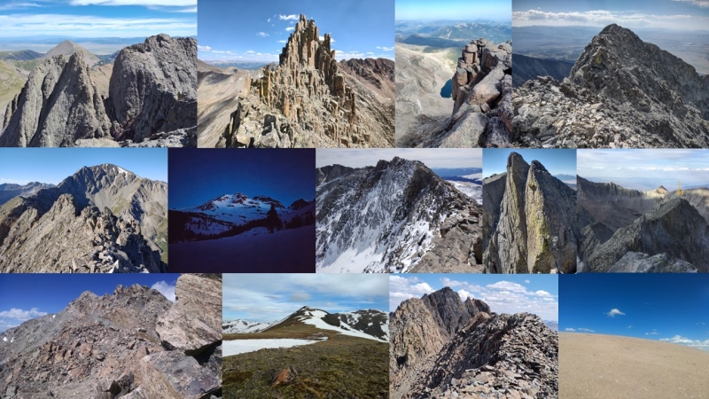
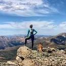
What is a 14er sub-summit? First, a quick note to explain this category that not a lot of people are familiar with. If you look on the 14ers map, under the peaks pullout menu you'll see the following selections for 14ers: Ranked (53) Unranked (5) Sub-Summits (15) These together give you the official list of Colorado's 53 14ers or the more commonly used list of 58 that includes the 5 named but unranked peaks (these five are named on USGS maps and other major sources but lack the required 300 foot prominence from saddle to summit to be considered ranked). Finally, there are the 15 sub-summits which are points adjacent to an established 14er which are also greater than 14,000ft in elevation but in addition to lacking 300ft prominence, they also aren't named on most official maps however they have been identified in one or more major publications such as one of Gerry Roach's books. When you add these 3 categories of 14ers, you arrive at the list of 73, which is what this report is about - or more specifically about the 15 sub-summits that bring the list of 58 14ers up to 73. Note, at one point this was a list of 74, back when Sunlight Spire had once been considered a 14er. But now that Lidar has bumped it down to a mere 13er, this list of 73 is much more easily attainable to the average climber. 14er Sub-summits: Best to Worst Below is my personal ranking of the 14er sub-summits, starting with my all-time favorite peak of NE Crestone. The detailed sections below for each peak will offer insight in to why I ranked them the way I did. 1) NE Crestone (best all around - really solid climbing, dramatic look/feel, two very different approach options, lots of other fun climbing nearby) 2) Pin Point (very short addition but unreal looking spires/gendarmes to scramble on) 3) SE Longs (unexpected top 3 thanks to combo of Iron Gates approach plus the dramatic views and positioning of this ramp-to-tower summit that floats precariously on a cliff) 4) South Little Bear (delightful approach when coming up the West Ridge Direct with the option to snag this sub-summit then back up and go over the Little Bear - Blanca Traverse) 5) East La Plata (really engaging climbing on the approach via Ellingwood Ridge, especially if you try to stay ridge proper) 6) South Wilson (fantastic snow climb in spring) 7) West Evans or is it West Blue Sky? (another unexpected delight - it's just barely above the rather boring standard route but the exposure is extreme on the NE side and has just enough scrambling to add some interest) 8) East Crestone (easiest add on ever - and it's within a foot of the height of Crestone Peak so it's a good idea to tag on this one in case the next Lidar like survey decides this one is actually higher. Great views!) 9) North Snowmass (Dramatically positioned for some cool photos, especially if you have a partner with you!) 10-12) North Massive, Massive Green, South Massive (great way to get multiple peaks in one day - these were the first sub-summits I did so I don't recall them as well as the others but I think there was a little scrambling) 13) South Elbert (This is a pretty ho-hum bump on the way up Elbert from the nice Black Cloud trailhead and across from the peacefully isolated Mt Cosgriff situated at a perfect overlook at the end of the ridge). 14) West Wilson (ultra-boring bump - or more like triple bump - along or just a smidge above the normal El Diente - Wilson traverse. Unlike its spicy gendarme brother Pin Point, you could pass over this without noticing) 15) South Bross (most barren and worthless hunk of rock on the planet - combined with tricky access issues due to private land, this one frankly isn't worth the time) In the below sections I give an overview of each of the 14er sub-summits. 1) NE Crestone 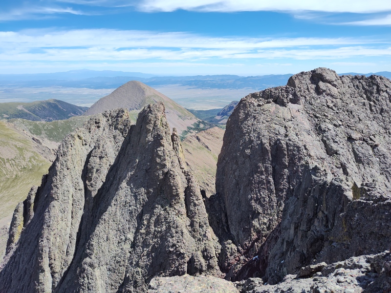
Difficulty ranking: Class 4 (but very solid) from Crestone Peak; or class 5 (very short but wickedly exposed) from North Buttress Best season to hike: Summer (the spice factor would increase greatly w/ snow/ice on this route) Special highlights: The Crestones offer some of the best and most solid scrambling/climbing in the state with their awesome Crestone conglomerate that has enormous, chunky holds that are generally super solid. NE Crestone is small but is an absolute jewel among a sea of great scrambling. Plus, you’re close enough to Crestone Peak that – if the wind isn’t howling too hard – you can sometimes hear the surprised comments of those watching you from there! Routes: Option 1) Class 4 route from Crestone Peak saddle (~14mi, ~6,200ft from South Colony Lakes). This is a fairly quick and easy add on to Crestone Peak as long as you’re comfortable on steep but solid class 4. You must first downclimb a somewhat loose gully from the Crestone Peak saddle that goes either class 3 or 4, depending on your line, and then take a few steps over to some short but superb class 4 climbing up the peak – or swing climbers left for greater exposure and terrain closer to class 5. Option 2) Class 5 North Buttress route from Bear’s Playground. (~13.5 miles, 7,400ft when looping North Buttress into Crestone Traverse from South Colony Lakes via Humboldt trail) This route starts from the Humboldt side of the Crestones, starting on the actual Humboldt trail itself, then hanging left (west) at the ridge to go to Bear’s Playground. From there you have a choose your own adventure option of anything from class 3 to class 5 weaving through, up or around various walls and towers up to a false summit. One little 5.0 downclimb gets you into the saddle then a very short but very spicey 10-15 feet of class 5 over fatal exposure gets you to the summit, or you can choose a much longer, descending traverse over fatal exposure along a crack reported to go at class 4, from where you could take the class 4 route up the far side of NE Crestone. Be warned the exposure is absolutely eye-popping at the crux! Adjacent bonus climbs: This makes for a very easy setup to go into the Crestone Traverse (one of the 4 Great Traverses in Colorado). For even more fun, start with the North Buttress route and then finish with the Crestone Traverse! Additional links: I love the Crestones so much (and NE Crestone in particular) that to date I've done 4 full trip reports (plus one mini that grabbed out extracts). The relevant reports for NE Crestone are: For the class 4 route from the Crestone Peak side: East and Northeast Crestone from Crestone Peak Saddle or the later Northeast Crestone revisited and explored For the class 5 from the North Buttress side: North Buttress to Crestone Traverse Bonus photos: 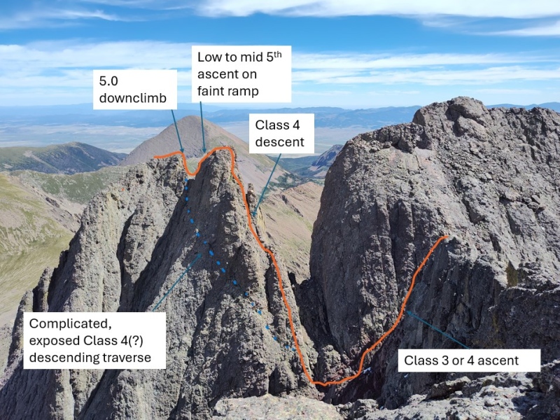

2) Pin Point 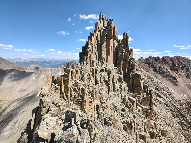
Difficulty ranking: Exposed class 5 up jagged spires from the El Diente side or Difficult class 3 from the Mt. Wilson side. Best season to hike: Summer for solid footing on the traverse. But looking over at it from South Wilson in the spring was quite beautiful... Special highlights: This is a very small but visually stunning sub-summit that is an absolute delight to climb! The class 5 scramble up these spires is not quite like anything else I've so far encountered. Yes, I realize "class 5" and "scramble" aren't usually used together but it feels appropriate for this unique feature. I'm no authority on ranking climbs but my inclination is to rank it easy 5th class, but others may go either higher or lower - not a lot of folks seem to have climbed this yet, so it may take time for a consensus ranking to develop. It almost feels like you're climbing up into some sort of Disney castle or something. Routes: El Diente to Wilson traverse - ridge direct variation (13.25mi, ~4,800ft). The standard El D-W Traverse is currently rated class 4 and by the standard route is considered the "easiest" of the 4 Great Traverses (not to be confused with "easy"). But this ridge direct variant bumps it up into class 5 territory and makes it more on par with the other Traverses. Adjacent bonus climbs: While you're going ridge direct anyways, it's fun to start that way straight off of El Diente. The standard route has you dropping down off the ridge into exposed class 3 terrain below the Organ Pipes. But if you instead stay ridge proper you can walk right through the Organ Pipes or, for maximum fun, even scramble up onto the Organ Pipes. But be very, very careful - the Organ Pipes can be fun to play on but a mis-step while climbing up onto them could very easily be fatal given the extreme exposure (people have died even on the much more mild class 3 bypass below). Additional links: For additional details and photos see my full trip report: Playing the Organ Pipes on Pins and Needles Bonus photos: 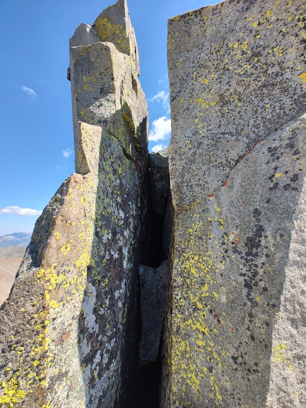
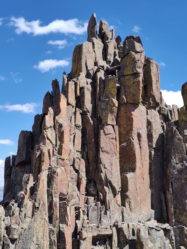
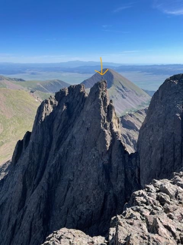
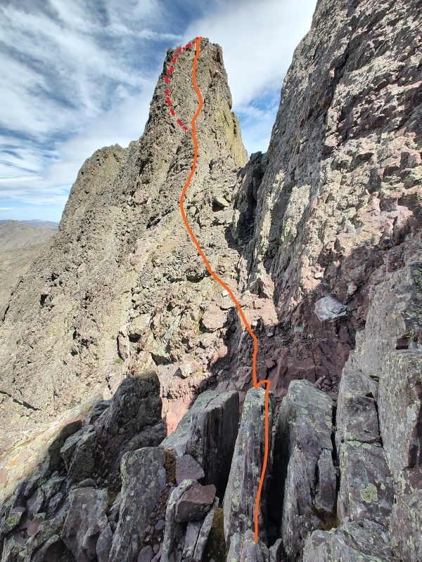
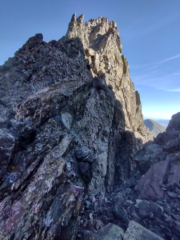
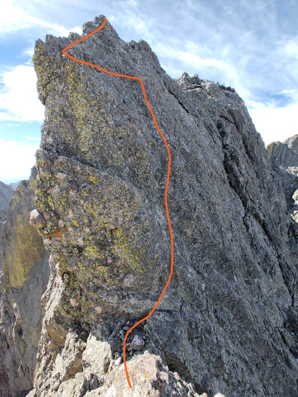
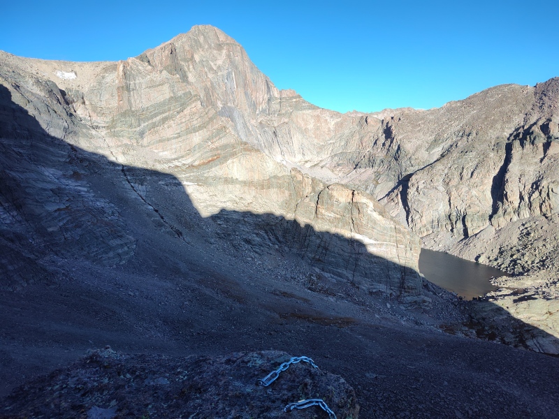
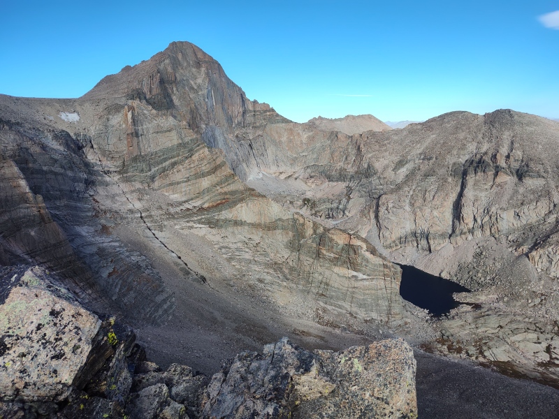
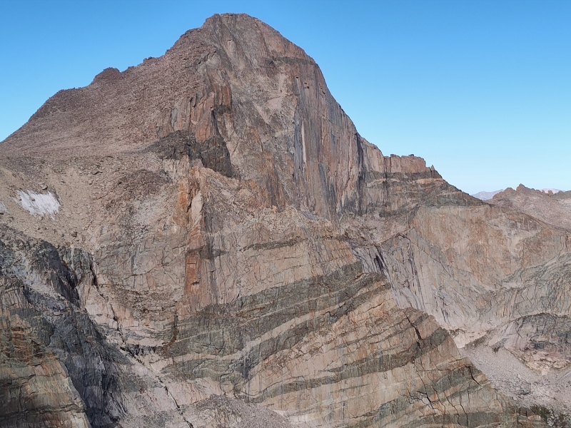
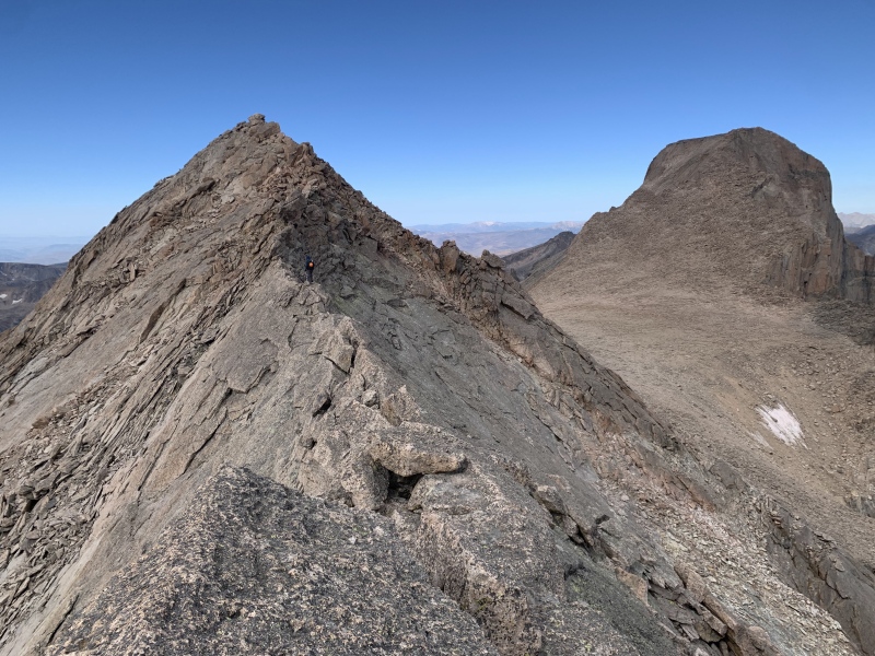
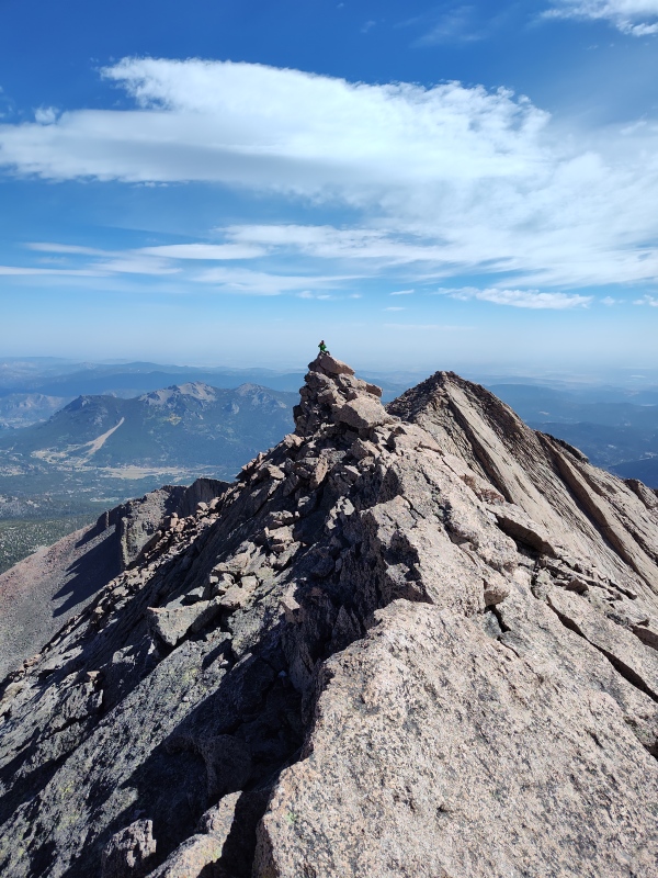
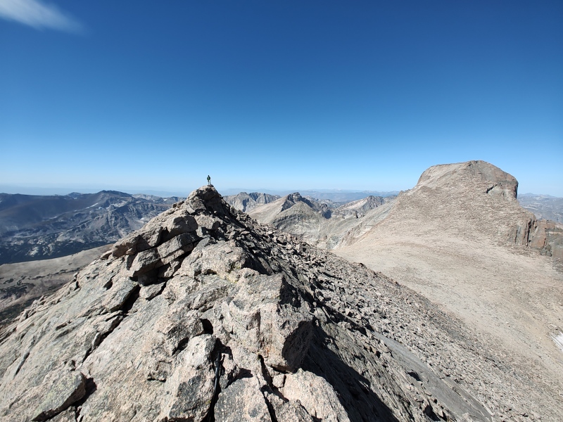
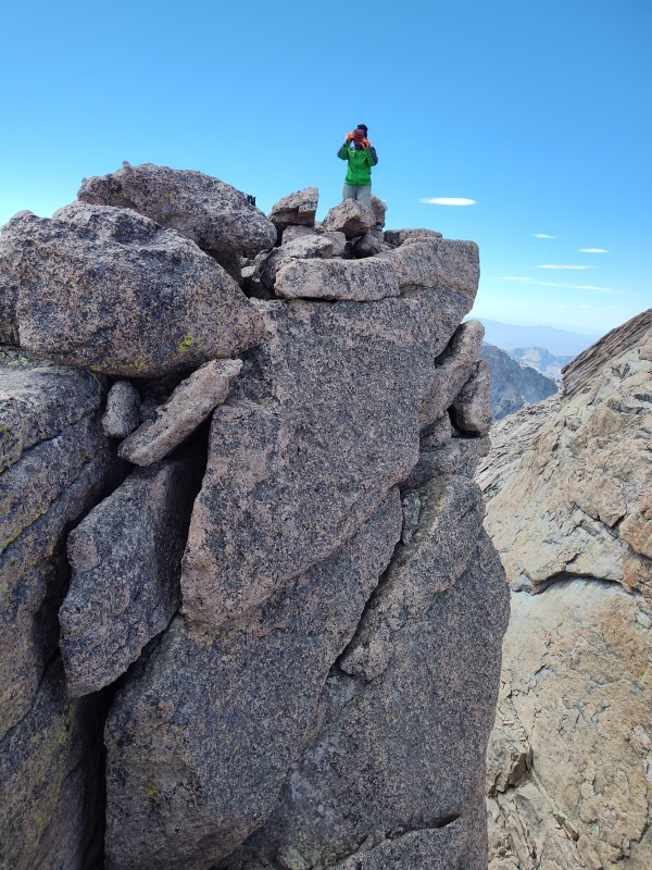
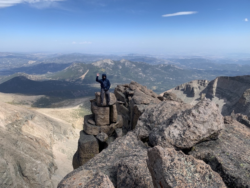
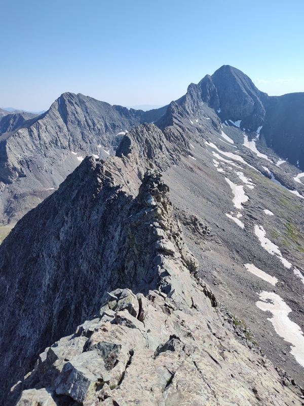
3) SE Longs 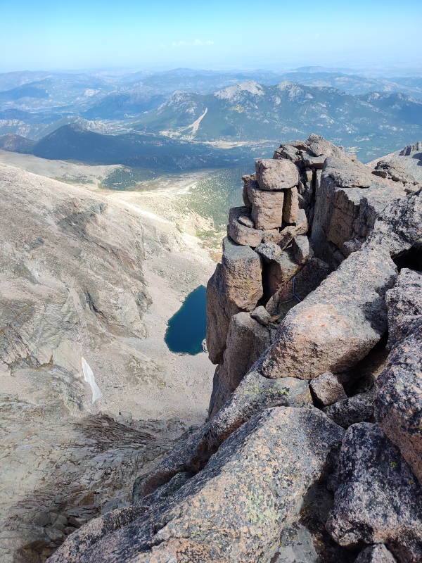
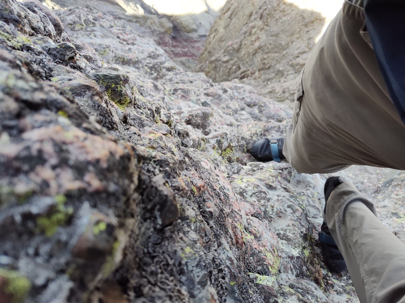
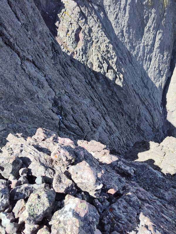
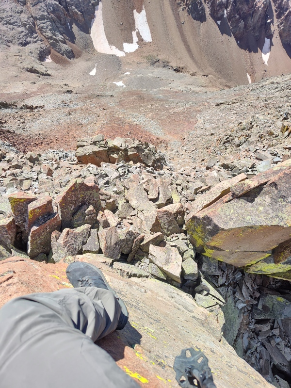
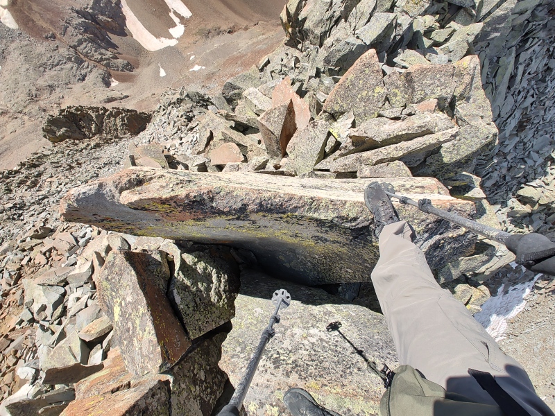
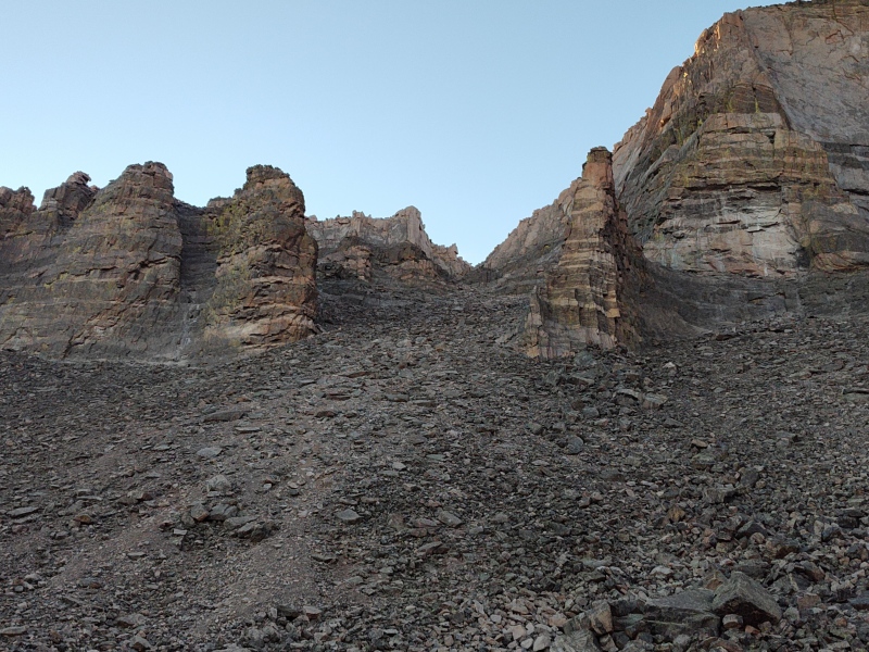
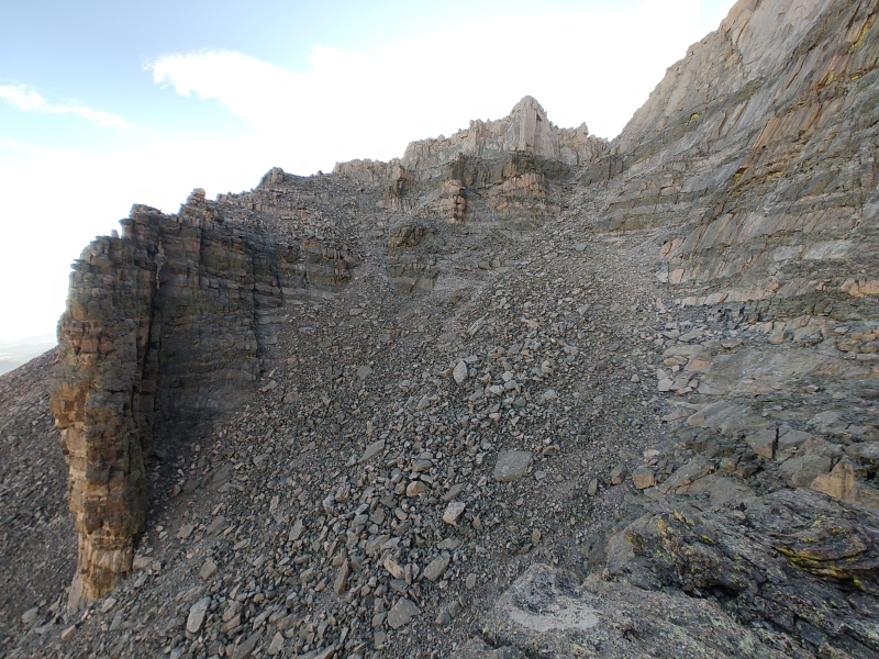
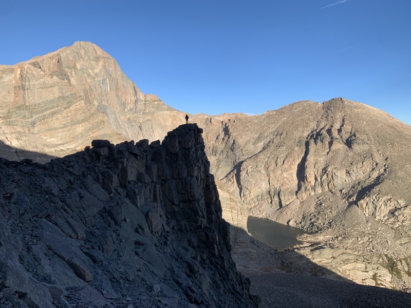
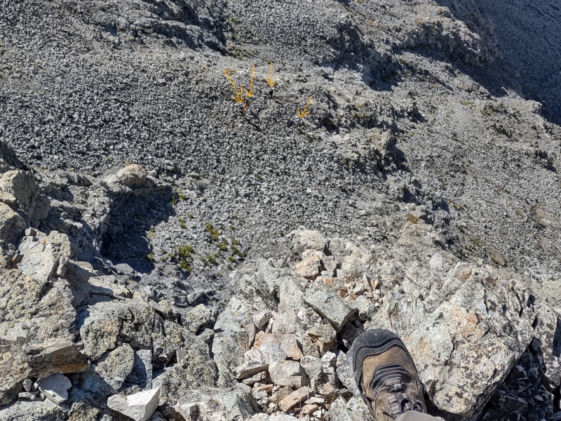
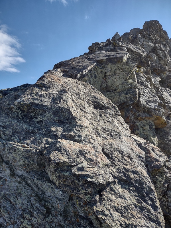
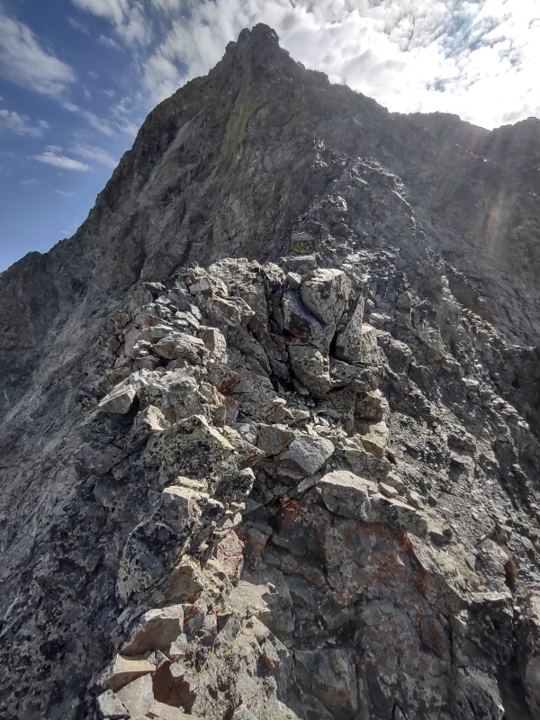
Difficulty ranking: Class 3 via either the Loft or the Iron Gates. Best season to hike: Summer through fall. The Loft route can start to ice up a little later in the season and the Loft can be prone to avalanches in the winter. Plus the Knife Edge between Meeker Ridge and Meeker would be more spicy when icy... Special highlights: This is beautifully located right off the summit of Longs Peak - close enough that when people walk to the edge they can easily see and wave to you. Can also see people at the bottom of the Homestretch from here and see part of Chasm Lake from the summit. Has a very dramatic looking rappel down into the notch between it and Longs Peaks. One of the most wild things is the huge open gap between the primary summit block and the rest of the broad slope leading up to the summit - you can easily see down a hundred feet or more! Plus when viewed from slightly to the west, the summit block seems to be hanging way out away from where that big gap is - with seemingly nothing to support it from below! Yet there is rappelling hardware permanently affixed to the far side of the summit block - the very section seemingly hanging in mid air! Kinda freaky... Routes: The most straightforward approach is to go up the Loft route for Longs but instead of dropping down around this sub-summit, just follow the gentle slope up it. For better views and more fun, cut left just past Chasm Lake and go up through the Iron Gates to Meeker Ridge, across the Knife Edge to Meeker (~12.75mi with some detours, 6k gain). Adjacent bonus climbs: Already mentioned the Iron Gates approach - someday I want to return and complete the Loft route to the summit of Longs (plus look at this summit from the notch to try to figure out what's holding it up there!) Additional links: Since this is the route I just completed prior to writing this report, I don't have another TR to link to. Instead I'm inserting a greater number of photos to highlight this route of going up the Iron Gates to SE Longs. Bonus photos and extended look at this route: The photos below, along with their captions, will essentially serve as my trip report for the Iron Gates to SE Longs route. 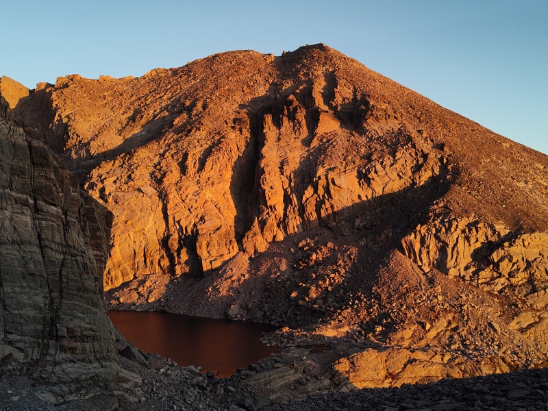
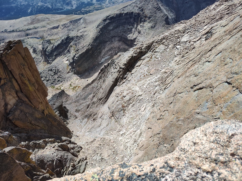
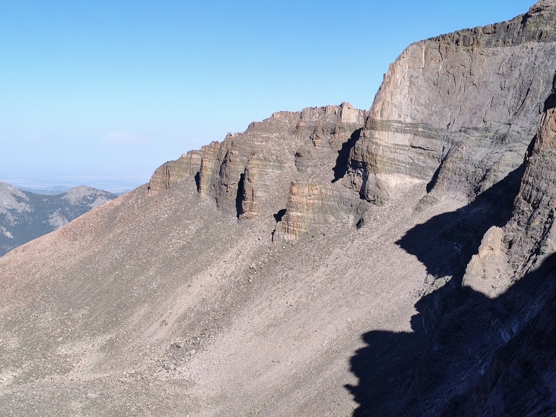
4) South Little Bear 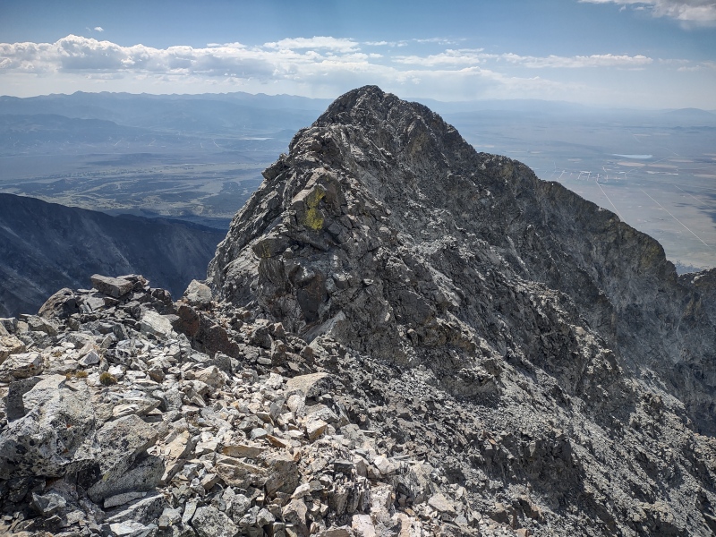
Difficulty ranking: Class 4 if approaching via the standard Hourglass Route or SW Ridge route; difficult class 3 if using West Ridge Indirect, or class 5 if approaching via West Ridge Direct Best season to hike: Summer is best for most routes due to steep and/or exposed routes. Reportedly SW Ridge route is more viable for winter but that's the only route of the above I've not yet done. Special highlights: The Hourglass approach is notorious for epic rockfall potential, so when I came back for this sub-summit I used West Ridge Direct which provided delightfully solid but wickedly exposed ridge scrambling with a few little bits of class 5 here and there. From the Little Bear summit it's largely class 3 to South Little Bear but depending on your exact line you may hit some class 4 or even a touch of class 5. Routes: Option 1) West Ridge Direct (~12.2mi RT, 6,300ft gain if start from 8,700ft on Lake Como Road) This is my preferred route up Little Bear. The exposure is off the charts - comparable to the Little Bear - Blanca Traverse and this is a great warm-up to see if you're ready for the Traverse (if you can handle this route you can handle the traverse - assuming you have enough endurance). Option 2) West Ridge Indirect (minimal difference in stats from the above) This is what I could see one day maybe taking over the Hourglass route as the standard way up Little Bear. It only has one brief section of fatal exposure as you first gain the ridge, then is pretty mellow compared to the other routes. Still needs a bit of refining to help solidify the specifics of the route. Option 3) West Ridge and Hourglass (14mi, 6,200ft to Little Bear if starting at 8k on Lake Como Road - minimal add on for South Little Bear) This is the standard route up Little Bear and is by far the best route if you want to maximize your opportunities of being decapitated and/or having your helmet and skull crushed down into a little tiny blob (yes, this is morbid sarcasm). If you somehow make it up/down this route without experiencing any rockfall (and to be fair, many people have) then you won't think it's that bad. But once you've had a rock missile rip past your head, you'll never forget it. Option 4) SW Ridge (~16mi, 6,700ft gain from 2WD parking) This is the only one of these options I've not yet done. It's a longer route with some bushwhacking at the start but reportedly a safer option for those hardy enough to attempt a winter ascent to claim the coveted blue snowflake. Adjacent bonus climbs: It would be a pretty easy setup to come up West Ridge Direct, make a quick detour for this sub-summit and then go on to the Little Bear - Blanca Traverse. Additional links: Little Bear was my Finisher peak for the list of 58 and has become one of my favorite peaks. As such, I so far have 4 full trip reports for this peak. The most relevant one for South Little Bear is Wrestling with Bears: West Ridge Direct plus South Little Bear but if you want to continue to the Little Bear Blanca Traverse then see also LB-B Traverse via West Ridge Indirect Bonus photos: 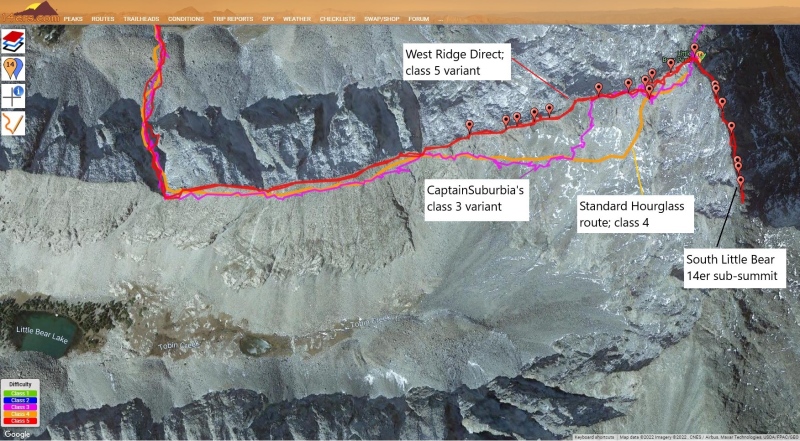
5) East La Plata 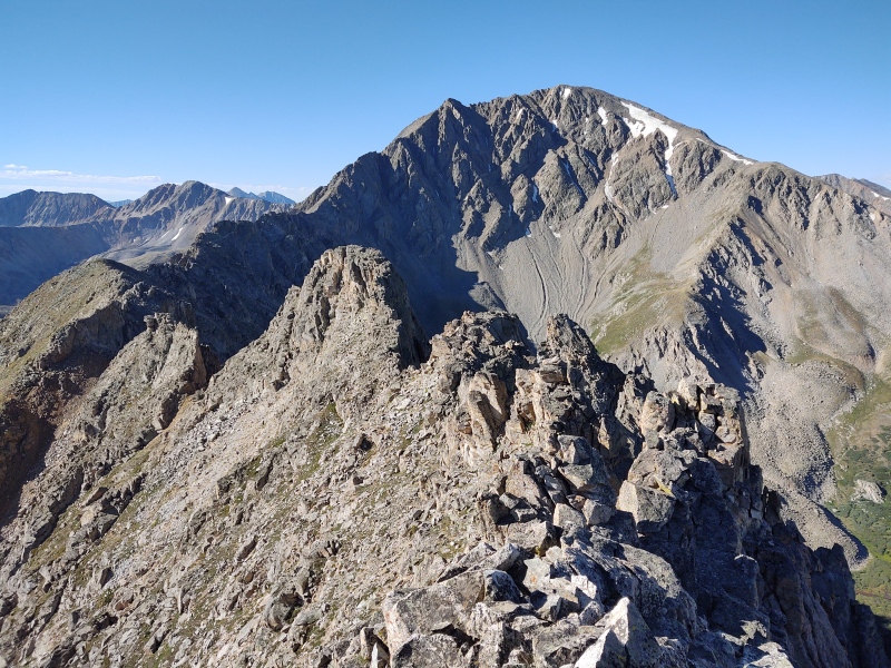
Difficulty ranking: Ellingwood Ridge up La Plata (not to be confused with Ellingwood Arete/Ledges up Crestone Needle) is class 3, but only if you drop way off the ridge down some sloppy gullies. Staying on the ridge would be a minimum class 4 and likely class 5 (I stayed slightly more ridge proper than the standard trail and hit some stout class 4 - would like to go back someday and try a more fully ridge proper approach). Best season to hike: Summer. This ridge would be a dangerous mess in winter, though you could take the winter route up La Plata and then do the short traverse over to East La Plata which would go at class 3. Special highlights: There's a lot of fun scrambling to be had on Ellingwood Ridge for those willing to explore in class 4 or class 5 terrain (again, don't confuse this with the more difficult Ellingwood Arete/Ledges up Crestone Needle). Routes: Going up Ellingwood Ridge is the only fun way to do this peak, but if you want to be boring, you could do it as a brief class 3 addition from La Plata via the standard route (~10.75mi, 4,750ft gain). Adjacent bonus climbs: Ellingwood Ridge (ridge proper-ish version) is the bonus. Additional links: I gave some details as well as comparisons to other fun scrambles for the Ellingwood Ridge route up La Plata vs several other routes. See 4 Classic Ridges: Ellingwood, Kelso, Sawtooth and Quandary West Ridge (plus Buckskin) Bonus photos: 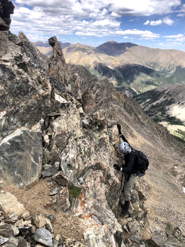
6) South Wilson 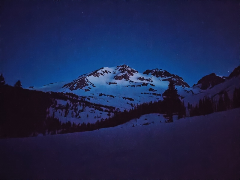
Difficulty ranking: Class 2 with moderate to steep snow climb Best season to hike: Spring snow climb (reportedly lots of very unpleasant loose dinner plate rocks if you do this route dry) Special highlights: This is a hauntingly beautiful area to go into by starlight when everything is draped in the white blanket left by winter. There are many towering slopes that command respect while winter's slabs continue to rest precariously upon them. Make sure you're very attuned to avalanche danger because this area will slide in winter from multiple directions! That's why waiting for stable spring snow is the safer way to go. This is a perhaps a good precursor to trying Wilson Peak in winter - reportedly the "easiest" of the Dirty Dozen - which is the hardest group of 14ers to do in calendar winter. Having done South Wilson as a snow climb, plus having done not quite half of the 14ers in winter, plus having ramped up my climbing skills, learned to winter camp, scouted Capitol and Pyramid with spring snow, etc, etc, I'm looking at possibly doing just that - and maybe even some of the other Dirty Dozen this coming winter - time and conditions permitting. Routes: Start from Cross Mountain Trailhead (just past Lizard Head Pass). Then take Mt. Wilson East Face trail to ~11,200ft then South Wilson SE face (path of least resistance). 12.25mi, 4,650ft gain Adjacent bonus climbs: Would be very spicy to try to do a direct connect, but if you're down there for the weekend you might try the El Diente - Wilson Traverse, though since South Wilson is best as a snow climb, that might not be an ideal time for the Traverse... Additional links: See the full trip report for this one at South Wilson Spring Climb Bonus photos: 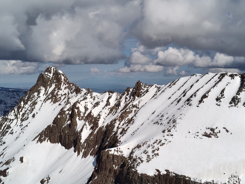
7) West Evans/West Blue Sky 
Difficulty ranking: Blue Sky from West Ridge is class 2 but by popping up onto the ridge proper you bump the difficulty up to class 3, if only just barely (and also increase exposure by an order of magnitude if you stay on the tip top). Best season to hike: Shoulder season or very start or end of winter when there's just enough snow to add dramatic highlights to the imposing cliffs above Summit Lake (I did this at the extreme tail end of calendar winter in March 2020 to capture the view above. Also repeated in September of 2024 when it's still a nice route but the cliffs don't "pop" quite as well when they're all dry). Special highlights: This adds a surprisingly dramatic feel to an otherwise rather tame trail over to Blue Sky (formerly Evans). It's not all that far above the standard route but there's a little scrambling fun added and some dramatic exposure on the very top of the ridge, as compared to the rather mild exposure of the standard trail. Routes: West Ridge from Guanella Pass is the route I've used both times except that I swung way left (north) of Gomer's Gully in order to go up low angle slopes to avoid avy danger. It could also be done from the standard Summit Lake Approach for Blue Sky, except that at the time of this writing the road is closed to vehicular and pedestrian traffic as the road is being redone. ~13mi 4k gain for just the Blue Sky peaks from Guanella Pass. Adjacent bonus climbs: A fun addition is to do the Sawtooth Traverse between Bierstadt and Sawtooth. It's most commonly done starting from Bierstadt but the last time I was on this route I did the Blue Sky peaks first and then did the Sawtooth Traverse in reverse. For even more fun, after dropping down on the ramp to start the traverse, pop up ridge proper and try to hold it. Quickly goes from class 3 to 4 to 5 - with some spicy options (but the traverse is easy to keep at class 3 if you stick to the standard route). Additional links: For additional details see 4 Peak Evans Ridge Route at end of winter Bonus photos: 
8) East Crestone 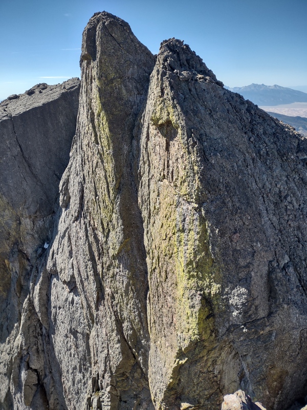
Difficulty ranking: Class 2 from the saddle with Crestone peak (but class 3 to get there by the standard trail). Best season to hike: Summer (the spice factor for the Crestones would increase rapidly with snow/ice). Special highlights: Lidar shows this peak is within about a foot of the altitude of adjacent Crestone Peak. So if your care about climbing the highest peaks, you might want to grab this one too just in case the next survey decides East Crestone is actually the higher of the two. It's the easiest add-on you'll ever find - even easier than adding North Eolus to a climb of Eolus. It's a very short class 2 jaunt up from the summit with Crestone Peak and puts you in an amazing centrally located position among the Crestone group to look around and see all the other peaks in the area. Routes: Crestone Peak South Face (the standard route up the Red Gully) is the most natural way to climb this sub-summit (~14mi, ~6,200ft from South Colony Lakes). But if you want to spice it up to class 5 you can instead approach from the North Buttress route described earlier under the NE Crestone section (~13.5 miles, 7,400ft when looping North Buttress into Crestone Traverse from South Colony Lakes via Humboldt trail). Adjacent bonus climbs: As mentioned in the NE Crestone section, once you're here, this is an easy launch point for the Crestone Traverse. Additional links: I'll re-paste the same links from the NE Crestone section here for easy reference for anyone just skimming through looking for beta: For the class 4 route from the Crestone Peak side: East and Northeast Crestone from Crestone Peak Saddle or the later Northeast Crestone revisited and explored For the class 5 from the North Buttress side: North Buttress to Crestone Traverse Bonus photos: 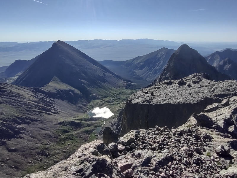
9) North Snowmass 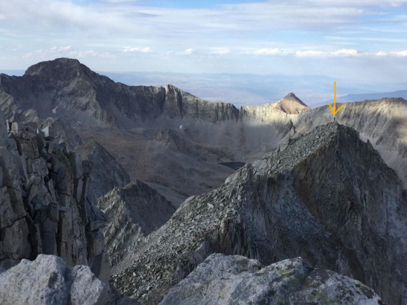
Difficulty ranking: Class 3 from either the standard route or the opposite side up S-Ridge but the add-on to North Snowmass is more like class 2. Best season to hike: Summer - otherwise it's a really long slog to get back there. Special highlights: This is an interestingly situated little peak sitting right out in the middle of a lot of dramatic looking Elks. It's only "a measly 0.17mi from Snowmass" as I put it in my trip report, but be warned there's quite the little drop in that very short distance, so while it's not a difficult add-on, it's not quite as trivial as a quick glance at a topo map might make it look. But the relatively low level of effort is worth the unique vantage point from over there. Bonus points if you get a friend to wait on the other summit to take pictures! Routes: I took the S-Ridge up Snowmass from Lead King Basin which is a fun but long class 3 scramble but you could just as easily add it on from the standard East Slopes route up Snowmass Total mileage = 9.7mi; total elevation gain = ~5,417ft for S-Ridge route. Adjacent bonus climbs: Not really much you can easily add on since the nearest 13er (Hagerman) is reportedly very spicy as a direct connect and usually approached from the other side. Additional links: For more info see: Snowmass: Up S-Ridge, down West Slopes + N. Snowmass 10-12) North Massive, Massive Green, South Massive 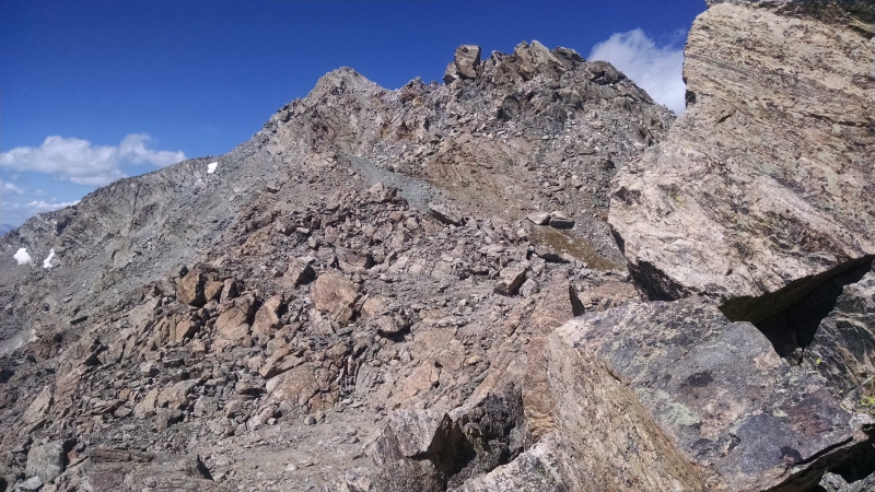
Difficulty ranking: Class 2 to Massive and I think for much of the additional peaks (these were the ones I did the longest time ago, before I took notes as detailed as these days) but from the looks of the pictures there might have been a little class 3 in there (I was definitely not doing class 4 or above back in those days...) Best season to hike: Summer, since it's a long slog back there, but I'll need to go back in winter at some point if I continue with the winter 14ers since I failed to tag North Massive when I got my snowflake for Massive, and North Massive was at some point added to the list of what was considered necessary to say you're a Frozen Finisher. Special highlights: Simply the fact that you can get a 14er and 3 14er sub-summits in one hike - plus I also hit a 5th bump over 14k and these days there's now an identified adjacent 13er (South South Massive - yes, "South" is repeated twice in the name since there's already a 14er sub-summit by the name South Massive). Routes: I did the standard route up Massive with some out and back additions to grab the sub-summits. Would probably investigate alternatives if I were going today for the first time and wanting all the sub-summits plus the 13er, but as is I just need the 13er and a snowflake for North Massive (I don't have stats from my day but a quick search of the GPX library shows some loops running ~15mi w/ ~5k gain). Adjacent bonus climbs: Some people have tagged on a traverse to Oklahoma (the 13er, not the state). Supposed to be some good scrambling on that route. Additional links: I did these back in the day before I started churning out trip reports so no links to share but you can mine plenty of data from the GPX Library or searching other people's trip reports. 13) South Elbert 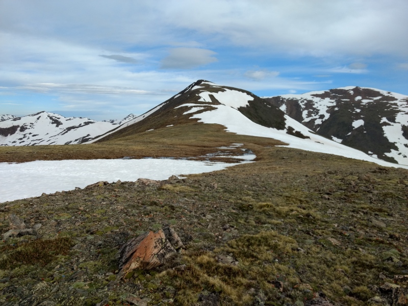
Difficulty ranking: Class 2, simply because there's a small portion without a prominently established trail. But it's as easy of a class 2 as you'll find out there. Best season to hike: Summer due to avy danger on the route from Black Cloud Trailhead in winter and not much motivation to hike back over here from Mt Elbert in winter. Special highlights: Not a lot to sell this one other than that it's perhaps a bit less crowded than the standard route up Elbert and it's a relatively pleasant hike. Routes: Mt. Elbert Southeast Ridge from Black Cloud trailhead is the logical way to do this sub-summit since you'll hit it on the way to Elbert. Would be a hard sell to take the standard route up Elbert and then overshoot to get this sub-summit - not because of the route being hard, just no strong appeal to going out of your way too much for this one unless you just have a pleasant day with no other goals in mind (11.5mi, 5,250ft gain from Black Cloud). Adjacent bonus climbs: A surprise pleasant little add on is the unranked and extremely non-prominent little Mount Cosgriff. You do have to turn right (SE) instead of left at the ridge when coming up from Black Cloud trailhead, meaning you have to go in the opposite direction of South Elbert and Elbert, but it's only a tiny little detour and puts you at the end of the ridge where you have a beautiful overlook into the valley below looking down over the scenic Twin Lakes area. I've always thought that this would be a good place to go back up to on some lazy clear weather day when I have no motivation for any serious climb and take a book to just sit and read while occasionally glancing out over the valley below (hah, like maybe when I'm 90 years old and can't handle a more serious hike anymore!). Additional links: For more information see: Cosgriff & Company w/ avalanche analysis 14) West Wilson 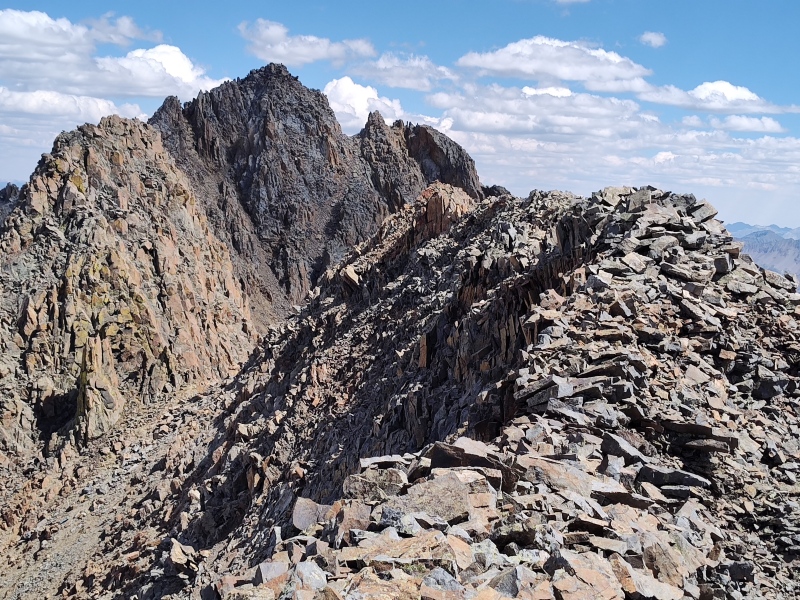
Difficulty ranking: Class 4, but only because the El Diente - Wilson Traverse is rated class 4. The "peak" itself - or whichever of the 3 rock humps the real peak is - is just a boring class 2 bump that people pass over (or sometimes next to) during the traverse. Best season to hike: Summer, due to tricky access and dicey conditions getting here once snow/ice show up. Special highlights: Getting there is half the fun. Strike that - getting there is all the fun. The highlights are strictly before/after the bumps themselves. Routes: El Diente to Wilson Traverse - make sure to stay ridge proper if you want to get this checked off the list - otherwise you might easily pass by without noticing. If you stay fully ridge proper the entire way you'll get the dramatic Organ Pipes as well as Pin Point (ranked #2 in this list - see up above if you've been skimming through looking for beta and missed it). 13.25mi, ~4,800ft. Adjacent bonus climbs: If you're out here already that means you're already doing the El Diente to Wilson Traverse (the "easiest" of the 4 Great Traverses). If you like unique, spicy climbs (which West Wilson absolutely is not) then be sure not to miss Pin Point - in between here and El Diente. Additional links: Same link as for Pin Point if you want more details on the ridge proper version of the Traverse: Playing the Organ Pipes on Pins and Needles 15) South Bross 
Special Note About Access: South Bross is the only peak on this list (at least as far as I'm aware of, and as of the time of this writing) where there are potential access issues due to private property concerns. Based on publicly available records, the summit of South Bross does not appear to be on private land, unlike the nearby summit of Mt. Bross which is currently closed to the public, but it could be difficult to find a route over to there that didn't cross private property. I'm sticking some fine print below that goes into the gory details - if you're already familiar or don't care, then skip to the larger font summary below. I've done the Decalibron loop a couple times, including once coming over to South Bross but these trips were well before the September 2021 closure of Mount Lindsey - which is the time when private property closures due to recent lawsuits really came to the forefront and started being taken more seriously by the general public (after some initial disputing). Prior to that time, although records show Bross being closed as far back as at least 2005, the understanding I had back in those days was that the "closure" of Mt. Bross was due to some old miner guy worrying that people were trying to steal minerals or such, as opposed to just walking up to tag a highpoint and move on. There were even tales/legends of supposedly years ago some old guy going around the summit on an ATV with a rifle chasing people away but reportedly people would go in groups and send a runner or two to distract the old guy while the rest of the group sprinted to the summit. I have no idea if there's any truth to those stories. But suffice to say, it was assumed back in those days that as long as you weren't stealing minerals and were careful not to fall into any old mining holes, that there was no reason not to hike from the approved trail just below the summit, up the last 50-100 feet or whatever it is to the real summit. Back in those days you might see 1,000 people on the Decalibron on a summer Saturday and 950 of them would go up to the real summit of Bross - I'm not saying that's the way it should have been - just the way that it was. But when the lawsuits started flying and Mt Lindsey closed in September 2021, it became apparent that this wasn't just due to some out of touch old miner enforcing antiquated restrictions from a bygone era - there was real life fear of further lawsuits that made landowners nervous. That led the the temporary closure of the whole entire Decalibron loop on a couple of occasions - most recently in 2023 and, as CFI numbers show, these closures were more widely (though not universally) respected than the previous Bross prohibitions. Since then, CFI purchased land on Democrat and Cameron to allow full access but there are still disputes affecting access to Lincoln and Bross. So long story short - although the summit of South Bross itself doesn't appear to be on private land, it would be difficult to get there without crossing over some of the private land where access is currently not allowed. So my recommendation: just skip this one - you really won't be missing anything anyways. Difficulty ranking: Class 2 (There's basically a trail around pretty much the whole Decalibron though it breaks down a bit in places and there isn't a trail over to South Bross). Best season to hike: When hell freezes over. Seriously folks, between the disputes over access and the barren wasteland that is South Bross - I just wouldn't even bother. The "official" guidance for the Decalibron is to walk the approved trail that passes a little ways below the summit of Bross and that's supposed to "count" as a summit of Bross. I'd say that would be good enough for South Bross too - trust me, I went over to South Bross (before I was aware of all the issues in fine print above) and it just wasn't worth it. Special highlights: None. Absolutely none. Routes: Slight deviation from the standard Decalibron loop but note the off limits private property you would have to find a way to circumnavigate in order to do it by the book (but again, I recommend don't bother even trying). 10.5mi, 4,250ft gain for full loop including traverse from Buckskin. Adjacent bonus climbs: A fun route not too far away is the Buckskin to Democrat Traverse - a great intro into scrambling! Additional links: Enough has already been said about South Bross but if you want to follow up on the Buckskin to Democrat Traverse you can find info on that at Buckskin to Decalibron traverse plus South Bross Closing Thoughts: Many of my trip reports end with a break down of my times going from point to point on a trail so that, even if you're faster or slower than me, you can get some general idea for the relative effort needed to get between points. If you want that kind of info for these 14er sub-summits, feel free to follow the links at the end of most of the sections where you'll find that data and much more. Overall, I think that the 14er sub-summits (with the exception of South Bross) make a wonderful addition the the main 58 14ers and so I encourage people who want a broader and more fun experience on the 14ers to go after this list of 73 where you can get class 4 or even class 5 action added, get access to 3 of the 4 Great Traverses in Colorado (only the Bells Traverse doesn't have a nearby 14er sub-summit) and generally get some amazing views of well known peaks from much less common angles. GPX File: Since my Finisher route was SE Longs, I'm attaching the gpx tracks for that route to this report. For gpx files of the other routes, see the link at the end of each section or search the GPX library. Thumbnails for uploaded photos (click to open slideshow): ")
")
")
")
")
")
")
")
")
")
")
")
")
")
")
")
")
")
")
")
")
")
")
")
")
")
")
")
")
")
")
")
")
")
")
")
")
")
")
")
")
")
")
")
")
")
")
")
")
")
|
| Comments or Questions | ||||||||||||
|---|---|---|---|---|---|---|---|---|---|---|---|---|
|
Caution: The information contained in this report may not be accurate and should not be the only resource used in preparation for your climb. Failure to have the necessary experience, physical conditioning, supplies or equipment can result in injury or death. 14ers.com and the author(s) of this report provide no warranties, either express or implied, that the information provided is accurate or reliable. By using the information provided, you agree to indemnify and hold harmless 14ers.com and the report author(s) with respect to any claims and demands against them, including any attorney fees and expenses. Please read the 14ers.com Safety and Disclaimer pages for more information.
Please respect private property: 14ers.com supports the rights of private landowners to determine how and by whom their land will be used. In Colorado, it is your responsibility to determine if land is private and to obtain the appropriate permission before entering the property.