Download Agreement, Release, and Acknowledgement of Risk:
You (the person requesting this file download) fully understand mountain climbing ("Activity") involves risks and dangers of serious bodily injury, including permanent disability, paralysis, and death ("Risks") and you fully accept and assume all such risks and all responsibility for losses, costs, and damages you incur as a result of your participation in this Activity.
You acknowledge that information in the file you have chosen to download may not be accurate and may contain errors. You agree to assume all risks when using this information and agree to release and discharge 14ers.com, 14ers Inc. and the author(s) of such information (collectively, the "Released Parties").
You hereby discharge the Released Parties from all damages, actions, claims and liabilities of any nature, specifically including, but not limited to, damages, actions, claims and liabilities arising from or related to the negligence of the Released Parties. You further agree to indemnify, hold harmless and defend 14ers.com, 14ers Inc. and each of the other Released Parties from and against any loss, damage, liability and expense, including costs and attorney fees, incurred by 14ers.com, 14ers Inc. or any of the other Released Parties as a result of you using information provided on the 14ers.com or 14ers Inc. websites.
You have read this agreement, fully understand its terms and intend it to be a complete and unconditional release of all liability to the greatest extent allowed by law and agree that if any portion of this agreement is held to be invalid the balance, notwithstanding, shall continue in full force and effect.
By clicking "OK" you agree to these terms. If you DO NOT agree, click "Cancel"...
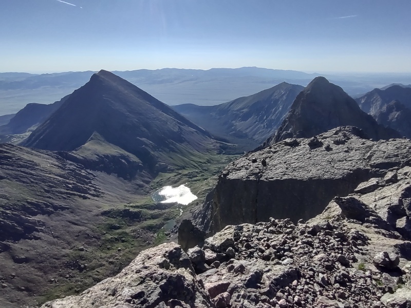
East and Northeast Crestone from Crestone Peak Saddle
This report will highlight a couple of really neat 14er sub-summits adjacent to Crestone Peak: East Crestone and Northeast Crestone. Note that I didn't summit Crestone Peak on this trip (been there, done that - I included it as a listed peak only for searchability since sub-summits don't currently show up in the drop down list for TR's) but I did come up the standard South Face route to the saddle for Crestone Peak before splitting to hit the sub-summits instead.
Peaks: East Crestone (14,298ft) and Northeast Crestone (14,257ft)
Route: Crestone Peak South Face to saddle - then free-form to the sub-summits
Trailhead: South Colony Lakes 4WD
Mileage/gain: ~14mi, ~6,200ft
East Crestone difficulty: easy class 3 (maybe class 2, depending on your line)
Northeast Crestone difficulty: class 4 for the climb itself but anywhere from class 3 to 5.low for getting there depending on the route and who you ask* (see above TR for confirmed class 3 route to the base of NE Crestone).
*Note: this is NOT the same as doing Northeast Crestone from the Humboldt side which is generally accepted as a highly exposed 5.6 route. This peak is easier from the Crestone Peak side, from what I understand - might have to try it from the Humboldt side one day to compare...). People having climbed up the North Buttress route from the Humboldt side seem more likely to rate the gully getting to NE Crestone as class 3; those downclimbing it are more likely to describe it as class 4. The wall next to the gully seems to be low 5th class.
Included in this report will be:
The backstory about ending up doing these peaks
A few notes/pictures about the route up through the Red Gully
A quick look at East Crestone
A detailed description of Northeast Crestone, including getting over there and getting up
Some humorous side-notes
A few assorted pictures on the surrounding area
My times
Me on top of Northeast Crestone (curtesy of a guy on Crestone Peak who watched me climb)
The Backstory - What's a 14er Sub-Summit Anyways?
If you only want beta on the sub-summits skip down to the section header for East Crestone.
This blurb covers why I was after these unofficial 14ers that only show up when you check the Sub-Summits box on the 14ers map. If you happened to have read my last trip report you might recall that through a long chain of random events I've gotten deeply involved in trying to help Geo (HikesInGeologicTime) finish the 14ers after a nearly fatal fall off Pyramid last year. Geo still hasn't got the Crestones checked off and so when a free weekend with decent weather showed up we decided to give Crestone Peak a go.
Unfortunately Geo's Pyramid injury flared up worse than usual and, after discussing options for a while - and knowing that the very high priority Pyramid re-match was scheduled soon (with help from a guide/rope to tackle the section where the fall occurred) - Geo decided to bail just below Broken Hand Pass so as not to jeopardize that venture (which of course has now been postponed due to weather, arrghh!)
But that left me free to go after a couple targets for which I have some newly reinvigorated interest: 14er sub-summits!
So what's a 14er sub-summit you ask? In the case of South Bross it's a pile of crap that no one in their right mind should waste their time with even apart from questions about access rights. But in the case of Northeast Crestone it's a fantastically sweet, bad-ass looking jagged spire of a peak that's ignored by the masses because of a picky little rule about not having 300ft of prominence. In the case of East Crestone it looks like a bland bump until you see it's jaw-dropping profile from Northeast Crestone and realize it only missed out on being the true summit of Crestone Peak by a foot or two.
Speaking of a foot or two - why do I have some newly reinvigorated interest in 14er sub-summits? Well, like the other "lists" out there, after finishing THE list of 58, I just wasn't eager to fully commit to any other specific goal that would eat up tons of time and dictate all my plans, but I've continued to check the boxes and idly peek every now and then at where I stand in regards to various other possible goals, including the list of 74 sub-summits...
74 sub-summits? But I just went to the checklist page and selected both ranked/unranked and named/unnamed 14ers and it only shows 73 total 14ers when the sub-summits are included...
EXACTLY!!! Why is it 73 now instead of 74? Hello LiDAR... I had been half-interestedly following the LiDAR thread and sort of thinking, "oh great, yet another list to deal with..." when an interesting little detail emerged: Sunlight Spire - with the infamous 5.10d route to the summit - had been demoted again to 13er status. At first I just kind of noted it with a shrug since that wasn't really on my radar.
But then I saw Bill finally started updating the 14ers lists with the LiDAR info folks have been collecting over on listsofjohn. As I clicked around and saw that North Maroon is now a fully official 14er I also did a double take when I saw that the list of 74 was now a list of only 73 and I had only 6 sub-summits left to finish another list! With Sunlight Spire kicked out of the club, that left - to the best of my recollection - Northeast Crestone as one of the most difficult remaining sub-summits but I also saw a report or two hinting that it might be doable by a class 4 route!
GAME ON!!! Originally Geo and I were going to go up to the Crestone Peak saddle together, I'd zip up and tag the easy East Crestone real quick, come down and tag Crestone Peak together and then get Geo to hang out and take pictures while I tried to tag Northeast Crestone. But when Geo bailed I dropped Crestone Peak from the target list and just went for the sub-summits.
The Approach
So on to the route, though this section will just include a few notes on getting to the saddle, so if you're already familiar with the standard route for Crestone Peak you can skip to the next section for sub-summit beta.
Broken Hand Pass tends to annoy no small number of people with its loose class 3 scramble. It's really not too bad if you pick the right line up it... but if you blunder in the darkness and are impatient to get up top like I was, just be aware you might end up on some exposed class 4 by mistake.
And even on the way down, when it was light, I somehow blundered the route so badly that I found myself doing a couple class 5 moves to get back on route, but SPOILER ALERT: I was already ready for that based on what happened in between to going and return...
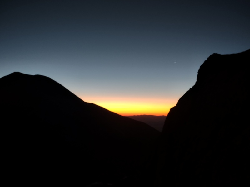
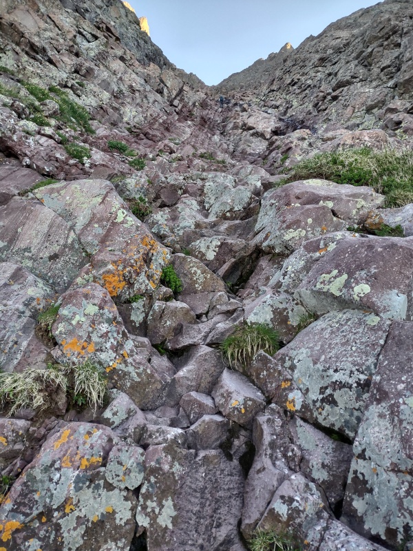
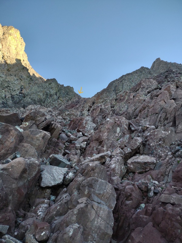
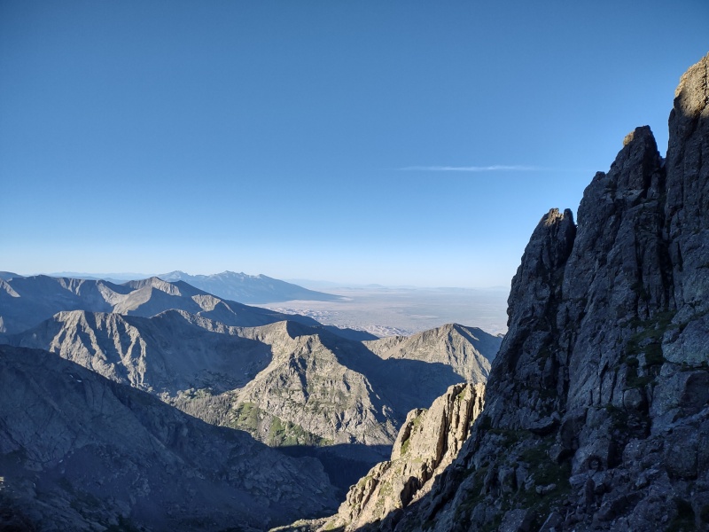
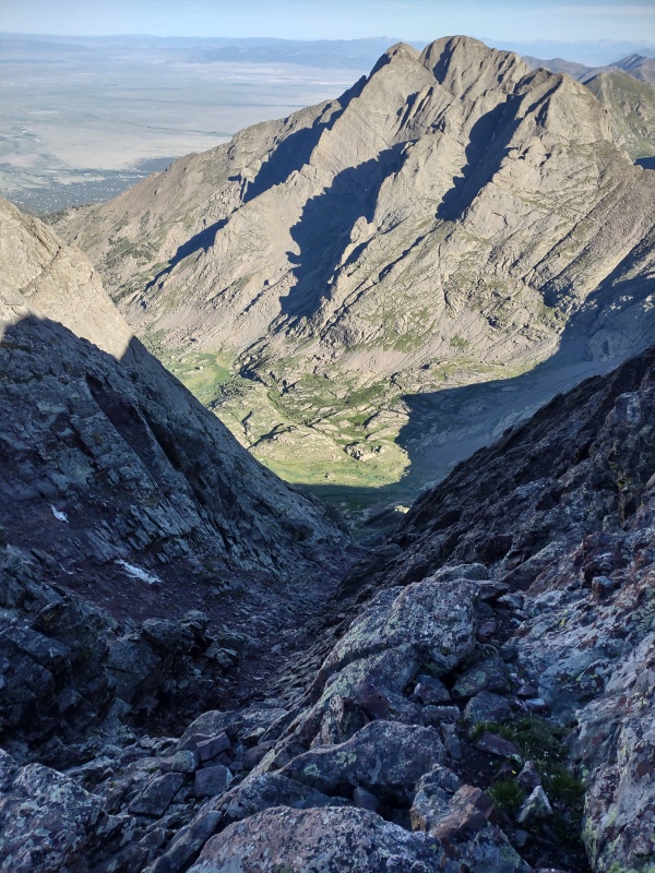
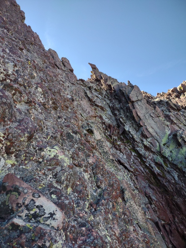
Looking back just below Broken Hand Pass at the sunrise.Going up the Red Gully on Crestone Peak. Note the hiker near center top for scale.Nearing top of the Red Gully. Arrow points out hiker at top for scale. Photos make it look steeper than it is.View looking out from the Red Gully at the Sand Dunes in the distance.
A couple quick notes about the Red Gully up Crestone Peak:
It's not as steep as the pictures make it look
Unlike elsewhere in the Crestones, there's a whole lot of loose garbage rock in the gully - and YES, it does sometimes come down - and FAST!!!
In fact, going up, a couple pairs of folks passed me and then a while later I hear ROCK!!! ROCK!!! Thankfully I had paused just before this to move to the side of the gully and turn around to take the Sand Dunes photo above. But even so, I turned and looked up in time to have a sprinkling of pebbles pelt me in the face. So I quickly stepped even a little further to the left and flattened myself against a large boulder with my helmet facing upwards.
Just then a couple rocks about twice the size of a grapefruit went hurtling at high speed down the middle of the gully. I call those "assassin rocks" because anybody hit by something that size moving at that speed won't likely be going home...
Anyways, enough of the rockfall drama - if you've never had a close call with rocks you'll probably blow it off as nothing but once some Little Bear has spooked you, you'll react very rapidly ever after...
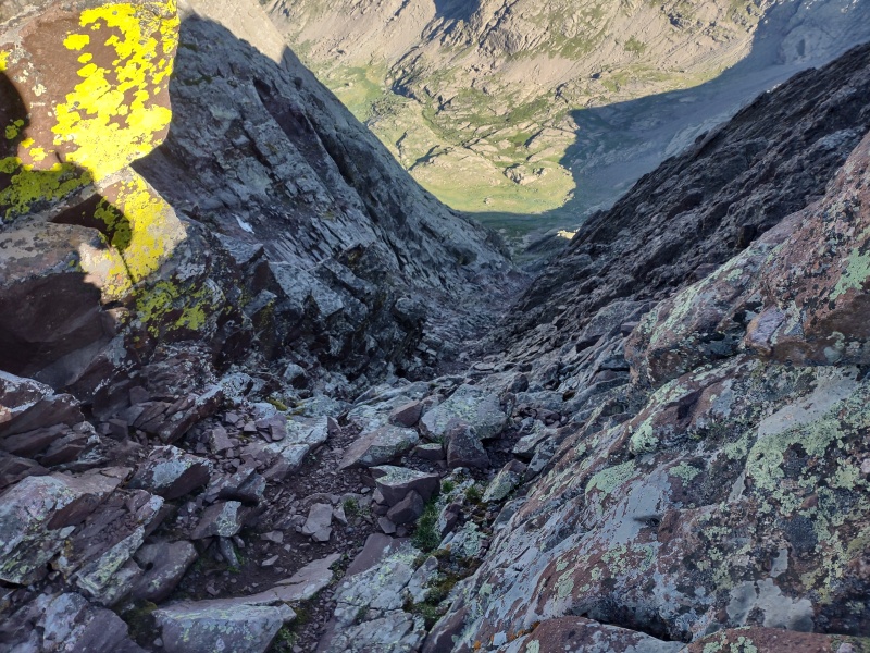
Great view of Kit Carson Avenue from the top of the Red Gully.Looking back down the Red Gully. Arrow shows hiker for scale. Again, photos tend to exaggerate the steepness.
East Crestone
Ok, now for the sub-summits!
East Crestone at first is very unimpressive - it just looks like a boring hump of rocks off to the opposite side of where you turn at the top of the Red Gully to go to the Crestone Peak summit. It's basically easy class 3 to walk up to the summit - you might even be able to keep it almost class 2 depending on how you go up.
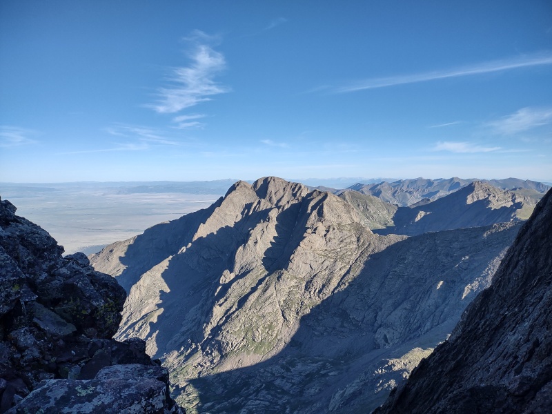
East Crestone from the saddle with Crestone Peak looks very unimpressive.It starts to look more impressive from the top...
But once you get to the top the views are fantastic (and just wait until you see this peak from Northeast Crestone...)
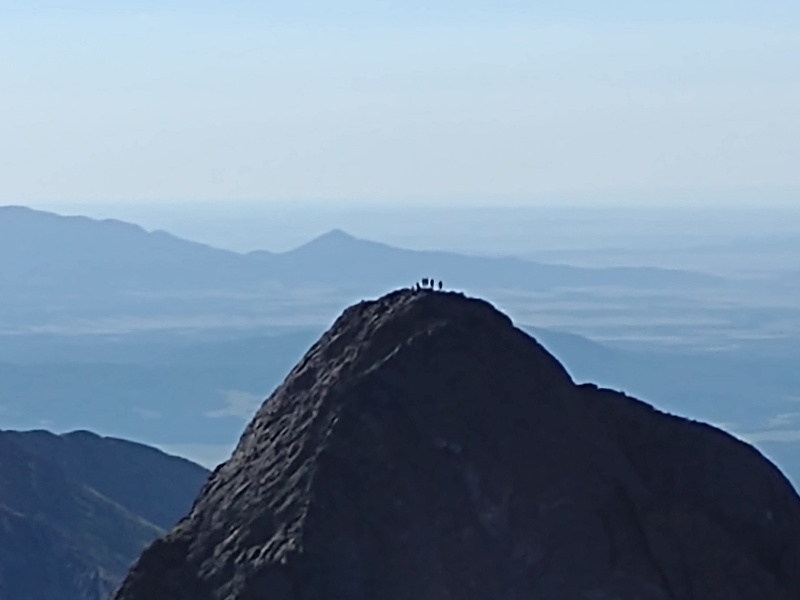
View of Crestone Needle from East Crestone.Zoomed in shot of Crestone Needle showing the folks on top.
FUN FACT: Did you know that East Crestone is only a foot or two shy of being the same elevation as Crestone Peak? A little erosion and maybe folks will have to climb this instead to finish the 14ers!!!
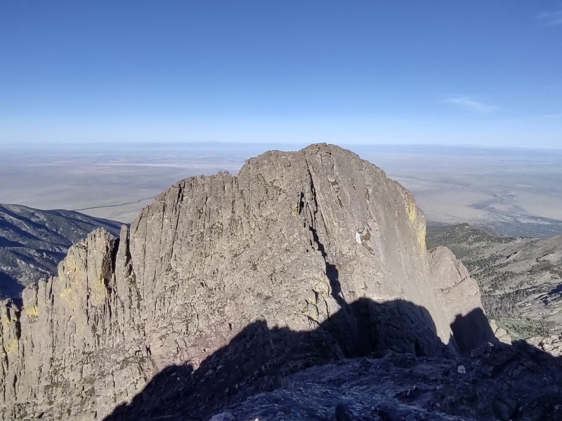
Crestone Peak from East Crestone - I could almost convince myself that Crestone Peak is actually lower in elevation...Crestone Needle (right) and Humboldt (left) from East Crestone.
East Crestone is also a fantastic place to scout out the route for Northeast Crestone - though the best place to do that is not from the actual summit but from a lower lip of rock closer to the Crestone Peak saddle.
Now getting to the summit of East Crestone doesn't involve much exposure (just the gentle slope down to the Red Gully - though granted you wouldn't want an uncontrolled tumble here) but if you want the best preview of Northeast Crestone you'll want to come down from the summit to that lower lip of rock on the Crestone Peak side. Just be forewarned that the exposure off that lower lip is
EPIC!!!
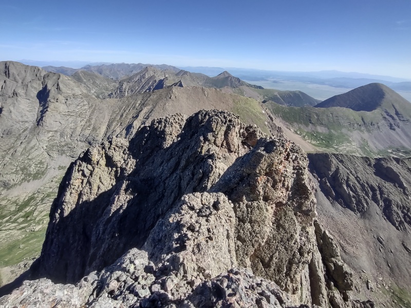
Standing on the edge of East Crestone's lower lipEast Crestone summit at left as seen from Northeast Crestone. Below right is the lower lip.
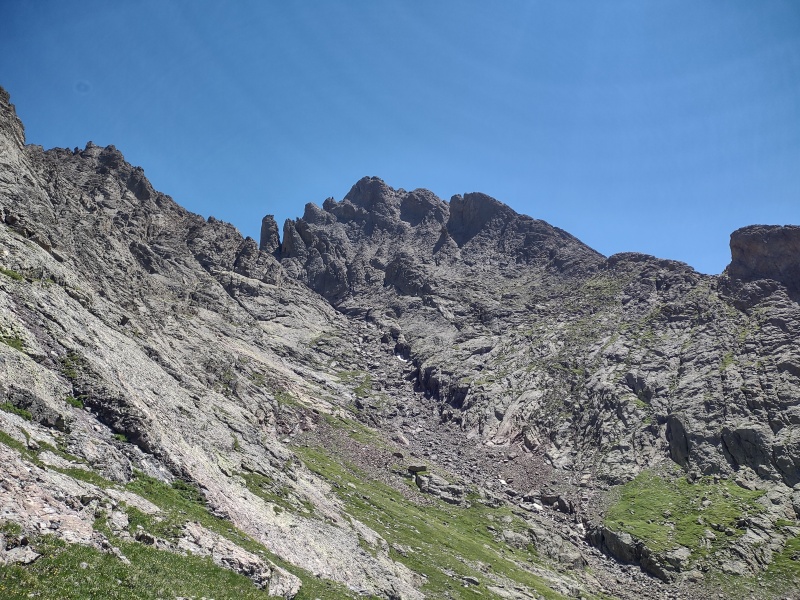
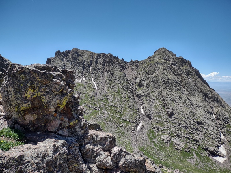
Northeast Crestone
So let's move on to Northeast Crestone - the true gem of this hike! From the saddle between Crestone Peak and East Crestone, this peak looks like a very gnarly, jagged spire that seems rather intimidating to go up.
So much so that many people coming up the saddle for Crestone Peak spotted me going up and stopped to watch - I'm pretty sure this was the first time I've drawn a crowd of onlookers in the mountains!
Hilarious sidenote: Once I was on the summit of NE Crestone a guy popped up on the saddle heading for Crestone Peak. I cracked up when I heard him quietly speak to his partner (probably not aware of how well voices carry in the mountains) and say:
"I need to check my route: that guy's way over there..."
Then in a louder voice he called over to me:
"Hey, are you on Crestone Peak or Crestone Needle!"
For a brief second I had to desperately fight the urge to mess with this guy's head by giving some answer that would totally throw him into confusion. But SAR gets enough activity in this region as is, so I decided to be nice and call back:
"Neither, I'm on Northeast Crestone. Crestone Peak is right behind you."
Lol, this is one of the reasons climbing sub-summits can be so much fun!
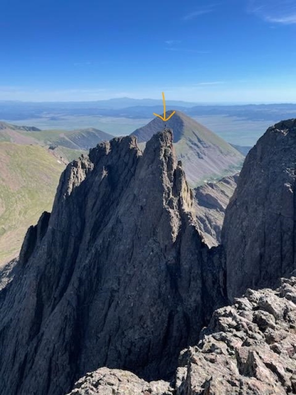
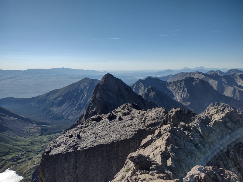
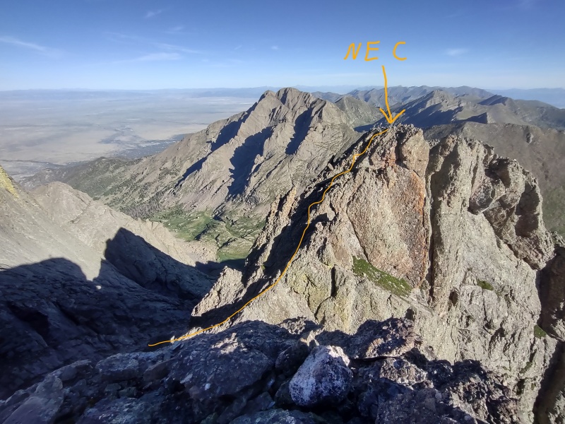
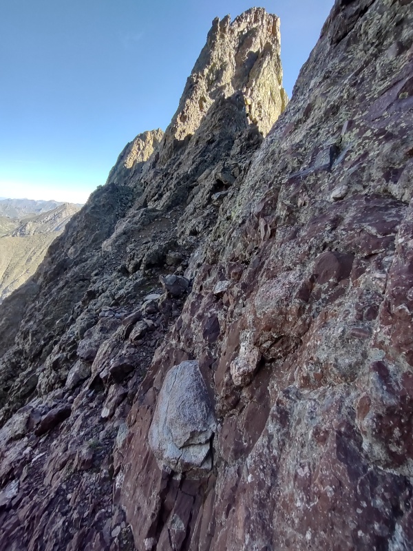
First view of Northeast Crestone from the saddle between Crestone Peak and East Crestone.From the saddle you have to drop down the opposite side from the Red Gully to head to NE Crestone.
Ok, back to the beta. So from the saddle you might look over there and think - no way. But go on up East Crestone and have a look before you give up.
Foreground is East Crestone with its lower lip in the sun to the left. NE Crestone juts up behind with Kit Carson Avenue visible back left.
From the actual summit of East Crestone you don't get the greatest look at NE Crestone but you can see enough to tell that the final pitch up isn't as steep as it looks from the saddle.
Then if you drop down over to the lower lip (seen in the sun in the photo above) and walk along its narrow, ultra exposed length then you'll get a great view of all of NE Crestone.
From East Crestone's lower lip you can see that NE Crestone isn't actually as steep as it looks like from below.From partway down EC you can see where you drop into the gully then pop back up and go up the ridge to NEC.
At this point you might be saying to yourself: "hot dog, I've totally got this one in the bag - piece of cake!!!"
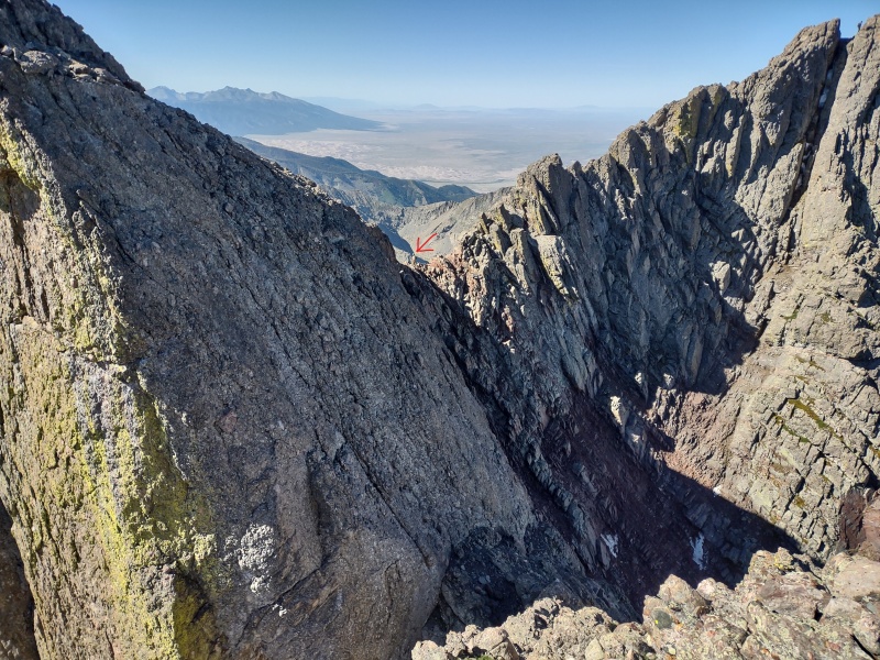
But hold on there partner... there's one little gotcha - did you notice the drop into the gully in the photo above?
Well guess what - getting there ain't half the fun... At least not how I did it, but there may be some options...
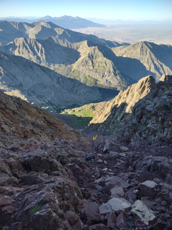
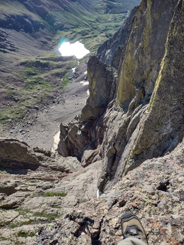
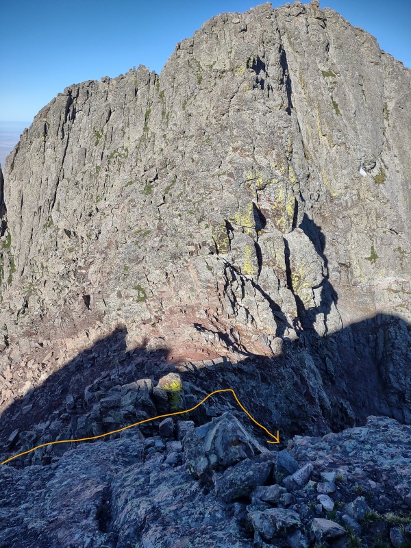
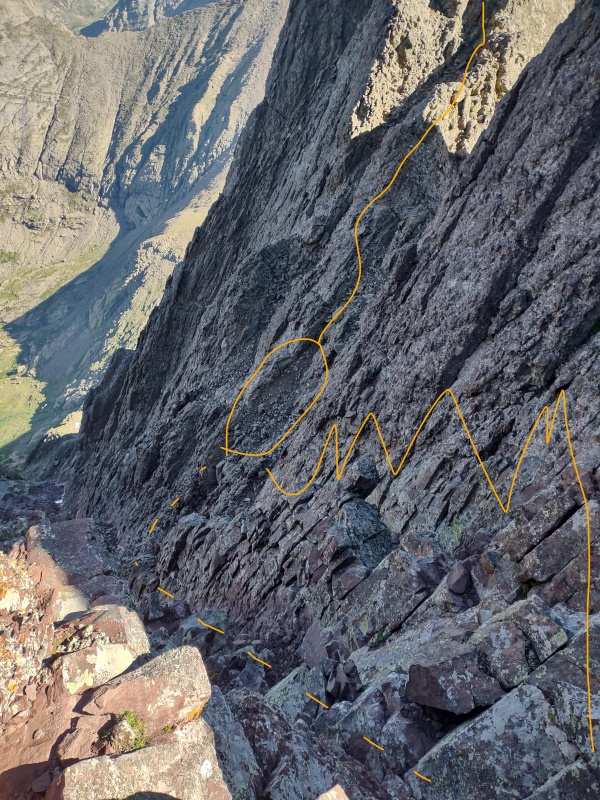
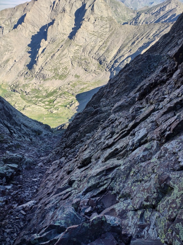
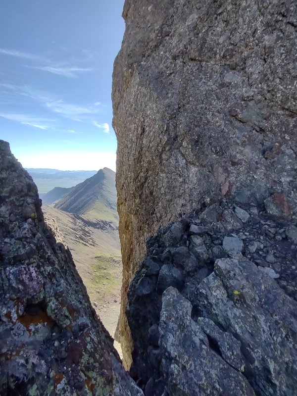
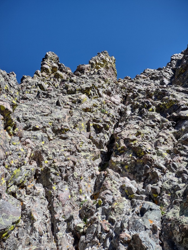
Looking down into the gully you have to drop into. Note Kit Carson in the background for orientation.Closer view looking down into the gully. That looks kind of like loose dirt and rock in the gully - why, yes, yes it is!
So the gully itself is a bit like the Red Gully on the other side of the saddle - some fairly solid ground but also plenty of loose dirt and rock - I'd say more so than the other side because I don't think hardly anyone travels this gully to knock the loose stuff away.
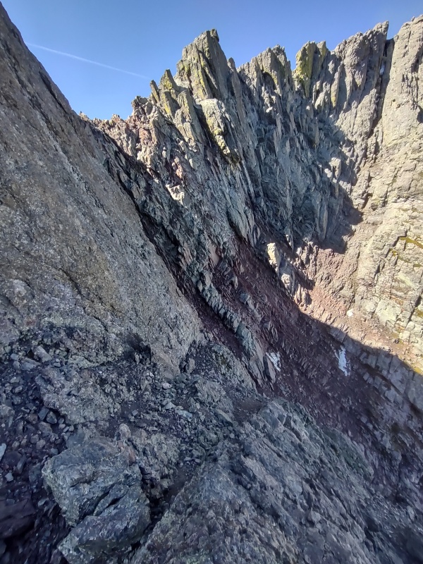
However on skiers right (climbers left on the return) there is a wall of that classic Crestone conglomerate. I almost went down that wall but lacked the confidence to downclimb something I had never seen before. In retrospect the wall is probably the more pleasant way to go but I'm thinking it probably goes at 5.low (I'm not good at judging ratings).
The gully itself I'm thinking could likely be considered class 4 (however some people rate it as low as class 3) but given the loose rock scattered randomly around I occasionally did some interesting class 5 stemming moves to avoid crushing myself by knocking loose some beast of a rock. While people vary on exactly what class to rate the gully everyone seems agreed that it's loose and requires care.
EDIT: go just a little to the left of this to get the class 3 version - see TR now linked at the top of this one.
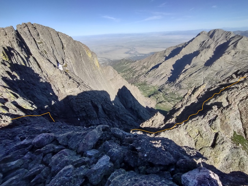
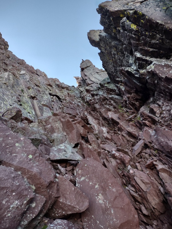
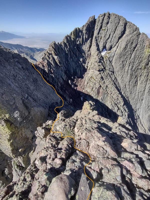
Dashed line was my class 4+ loose gully descent. Circle is landing zone, zigzag is approx 5.low ascent.From the landing zone its an easy stroll up a small ridge to some fun class 4 scramble on Crestone conglomerate.
As seen in photos above, your goal is to get to the "landing zone" - a level patch of dirt from which you can stand and scope out the remaining route. Going straight down the gully is less technical but more sketchy due to loose rock. On the way back I stayed climbers left of the gully and went up the really solid wall (I used a zigzag line in the earlier photo since I'm really not sure what the exact line was - it seemed like I moved left, away from the gully for a while before cutting back over).
Once you get to that landing zone everything else is going to feel easier. But you have to drop a ways to get there... Pointer Rock serves as a visual reference as you drop down.
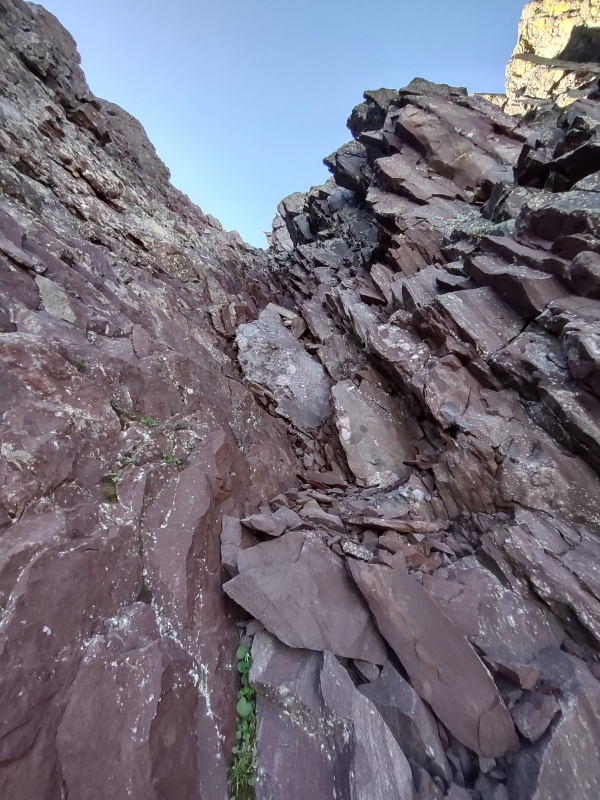
This lichen coated rock (closer to East Crestone than Crestone Peak) marks the logical drop down point.From below, Pointer Rock serves as a great visual marker to track your progress and guide you back up.Pointer Rock seen after descending a ways.Looking down the gully and its loose rubble.Pointer Rock from further down.And Pointer Rock from way down near the landing zone.
Once you get down near the level of the landing zone it will be very obvious - there's not really any fear of dropping too low.
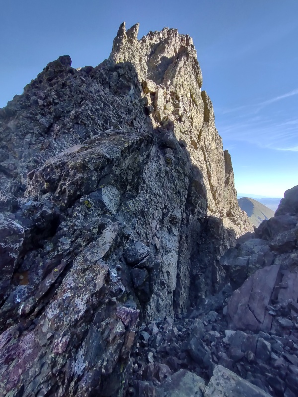
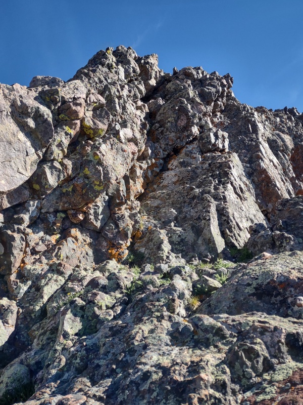
Your first obstacle with be a large hump (in the shadows in the photos below) which will leave you wondering if you should go up it or try to traverse around - just go straight up it - from the top you walk right over to the main climb.
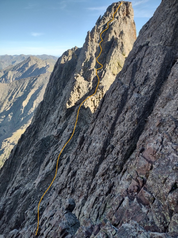
Finally getting down to the landing zone and looking over at NE Crestone.It's not clear at first glimpse if the hump in the shadows connects - it does; just go straight up it.Passing by the cliff face off the back of East Crestone.Approaching the main climb below the bunny ears.
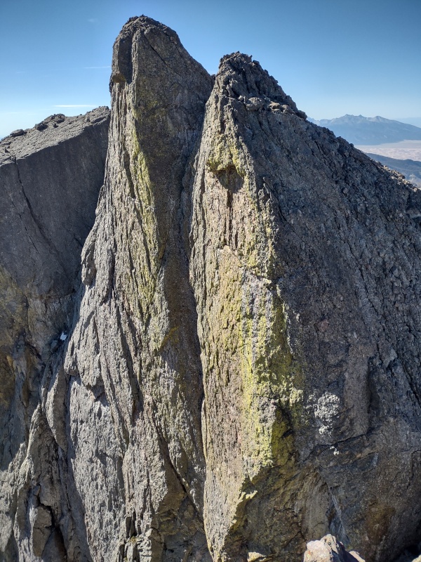
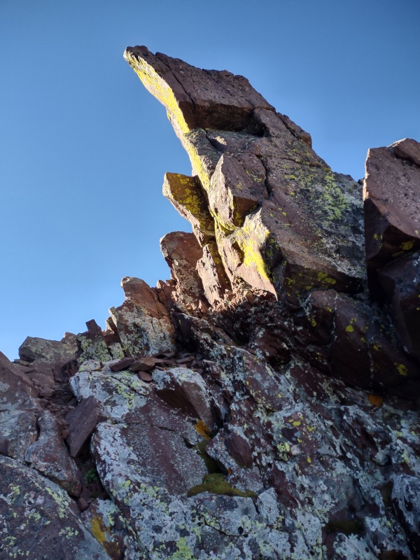
From these photos the main climb may still look really imposing and those bunny ears may look like one bad-ass bunny - but as with the Red Gully photos, the camera tends to give an exaggerated feel to the angle.
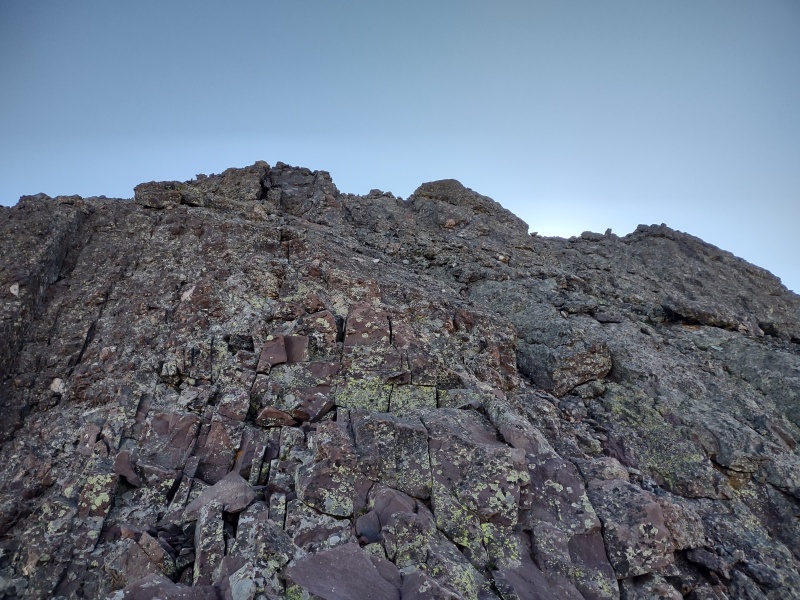
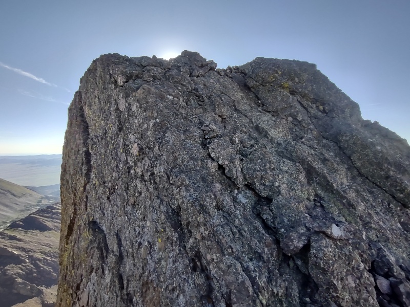
In reality this is the Crestones at their best - that legendary Crestone conglomerate that is 98% solid makes it a joy to scramble up the big chunky holds that are easier even than what you find on the lowest rated routes in a climbing gym. It shouldn't be too hard to keep the entire climb up this section class 4.
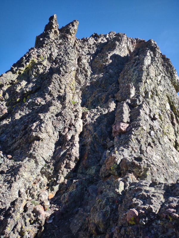
I was able to go up and down next to the bunny ears - one of which had an old rappel anchor on it.
The bad-ass bunny towering up - the summit is still up to the right.Beyond the bunny ears heading to the summit.
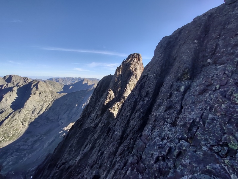
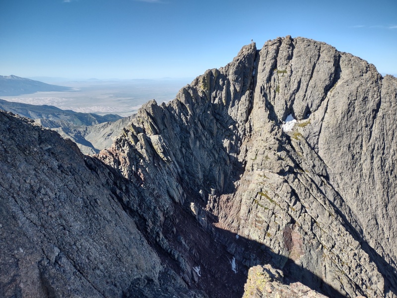
Looking over at Crestone Peak while going up NEC - note guy to the left of the summit for scale. Descent route is gash coming down from the saddle.Closer look at the guy going up Crestone Peak.
Once on the top, sit and soak in the views for a while and call over and chat with anyone coming up to the Crestone Peak saddle (it's not far as the bird flies - I could even make out shouts from all the way over on Crestone Needle!)
Up on NE Crestone looking at the lower hump beyond it which many people tackle first when coming up the North Buttress route from Humboldt side.
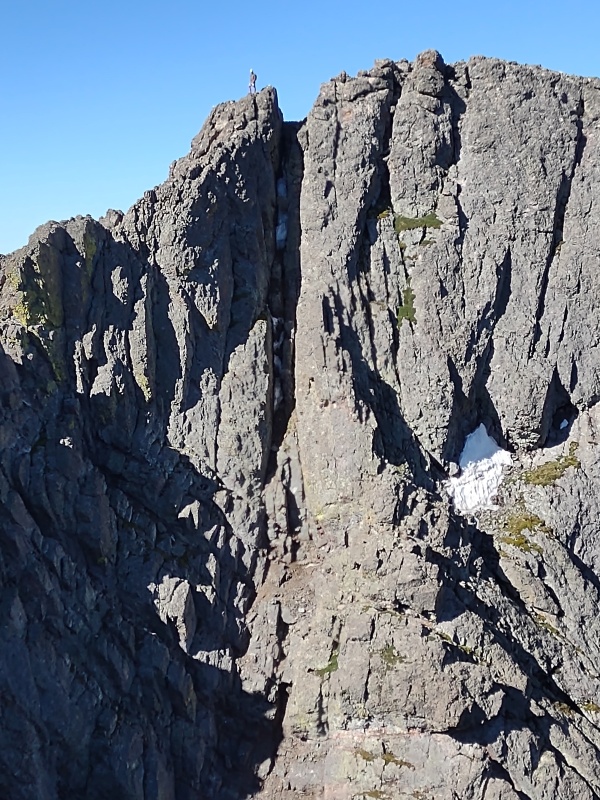
Looking down from the top it's easier to see how it's not as steep as it looks from over at the saddle. Don't get me wrong, you're definitely climbing up this section, as opposed to walking up with your hands in your pockets like you could do for many 14ers, but it's not like you're standing on the edge of a huge, sheer drop (like earlier on the lower lip of East Crestone).
Looking back down NEC and the route back to the saddle. This shows better how it's not as steep as it looks.A view from a different angle of the route back. Note the guy on the saddle for scale.One more view from lower down of getting back down into the gully - the gully is harder than the peak.Coming back up chunky Crestone conglomerate to the left of the gully, Pointer Rock providing the target.
Then, as described earlier, you have the option of going back up the loose gully (class 3 or 4 depending on who you ask and where you step) or ascending the 98% solid Crestone conglomerate to the left which was probably a 5.low wall but didn't feel bad at all with those huge, chunky solid holds.
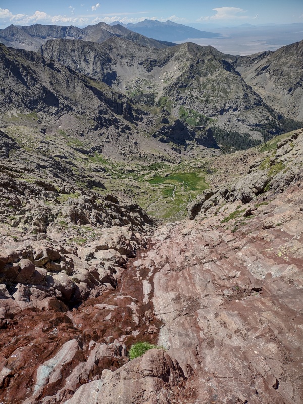
The Surrounding Area
After getting up the wall to the saddle and resting for a bit (plus passing my number off to the guy who snapped my photo from Crestone Peak) I began the long tedious descent down the Red Gully, paranoid the entire way about knocking rocks down on someone (I went super slow and avoiding knocking down anything).
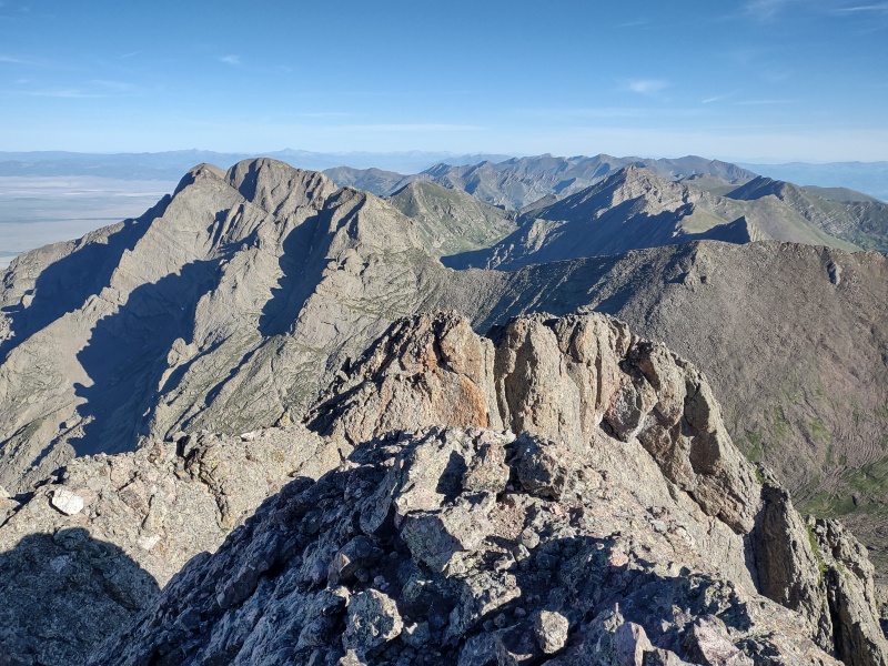
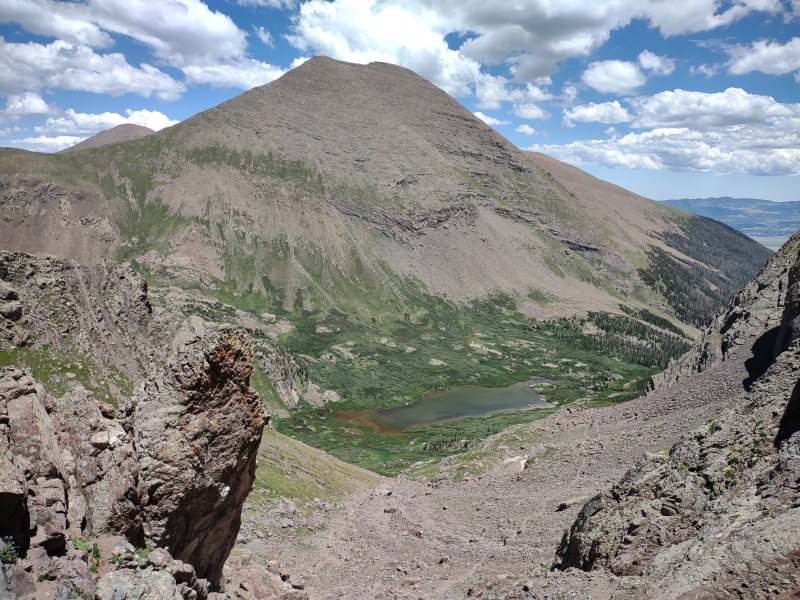
Once down, on the long plod back over and up BHP, I was struck by how many cool peaks and features are in this area - there is definitely more adventure to be had around the Crestones...
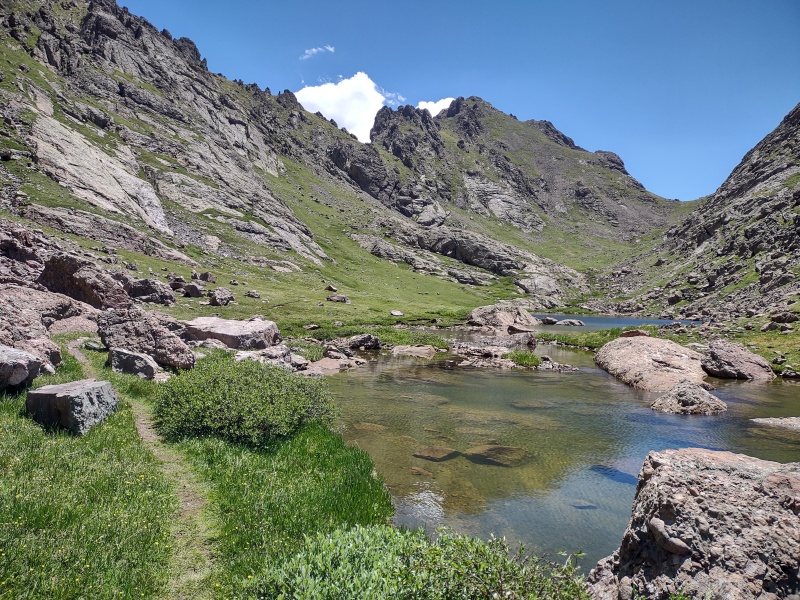
Coming down one of the slabby sections in the lower part of the Red Gully next to the water flowing down.Looking up at the Crestone Traverse and the iconic Black Gendarme - I'll have to come back for that some day...From the tip of Cottonwood Lake with Broken Hand Peak in view (a 13er I still need to tag) and the pass off to its left.Some wickedly cool rock formations in the region of BHP - maybe some day I'll try to come play on these...Looking over at Crestolita - another 13er that I'll have to come back for some day.Humboldt looking rather stately from Broken Hand Pass.
All in all, this was a really neat trip that got me more in love with Crestone conglomerate - I half jokingly told some folks that I could free solo El Capitan if it was made of this stuff!
My Times
Geo and I started from the current 4WD trailhead together up the very long road that once upon a time been a much longer 4WD road. Knowing that Geo would be moving slow we started crazy early to maximize the chance of summiting before any afternoon thunderstorms might roll in.
12:51am start from 4WD trailhead.
5:17am at top of Broken Hand Pass after Geo made a long hard effort but had to bail at the bottom of the pass due to the Pyramid foot injury acting up and not wanting to overly stress it before the upcoming Pyramid rematch.
6:13am up past the waterfall in the lower part of the Red Gully going up Crestone Peak.
6:40am stepped aside for divinely timed photo op of the Sand Dunes just before some "assassin rocks" came hurtling down the center of the gully.
7:40am top of the Red Gully at last.
7:53am head up East Crestone after a break.
8am on top of East Crestone.
8:35am ready to go for Northeast Crestone.
8:56am down at the saddle between NE and E Crestone.
9:05am NE Crestone summit.
9:39am back at main Crestone Peak saddle after enjoying NEC for a while.
9:58am start down.
11:41am completely down and out of that awful Red Gully - yes, it took me longer going down than going up which is extremely unusual for me - I was just so paranoid about knocking stuff down on the large number of folks in the gully.
11:58am Cottonwood Lake.
12:25pm Back on top of Broken Hand Pass.
1:11pm clear of main downclimb off BHP despite having gotten horribly off route and inadvertently turning it into a class 5 descent - by that time my confidence on class 5 terrain had received a large boost but I was getting tired and my patience for route finding had plummeted so after a couple false starts I said, oh forget it - just send it...
2:44pm back at the Jeep.
My GPS Tracks on Google Maps (made from a .GPX file upload):
I would like to thank you for bringing this list to my attention, I was completely unaware but then looked and I only need Northeast Crestone, South Wilson, South Bross, Southeast Longs, and South LB. I will look further into it. Also, nice work, that route on NE Crestone looks tough. I descended the northeast couloir of Crestone Peak a couple years ago to combine it with Humboldt, and remember a 3rd class way down into your gully but it has been a while so I could be wrong. Anyway, When I go back to do the traverse I will have to bag this amazing little peak you have showed me. Have fun out there!
You could possibly be right on the gully - being a downclimb into unfamiliar territory may have made it feel harder than it was. I reviewed some of the handful of reports out there that mention this gully (prior to the trip it was sometimes hard to discern what routes people were taking) and it looks like some call it class 3, some call it class 4, though also some came from the Humboldt side and climbed up vs down from Crestone. Likely would have felt more like class 3 going up, especially if you had just climbed up North Buttress... I'll tweak my descriptions to mention the different ratings people give.
The ~1am is a very early start. I wonder if you have any thoughts on how an early start (probably little/no sleep) impacts the climb, and the trade-offs of starting later.
Yes, that was especially early, though we were laying down by 7pm the night before - not necessarily sleeping but at least resting. The main motivation for such an early start was my friend's lingering injury from falling off Pyramid last year and wanting to be below treeline before t-storms could roll in. Main drawbacks are 1) less sleep 2) doing BHP in the dark. In my case I did ok despite both those. BHP might have been smoother with a later start but it wasn't a real issue for me. Depending on how fast you hike, how well you navigate in the dark and how well you operate on limited sleep you have to make your own call on that.
Great trip report! How accurate is the East Crestone elevation (14,298') listed here? Wikipedia (https://en.wikipedia.org/wiki/Crestone_Peak) lists 14,266', and while based on an older survey, a ~32' adjustment is not very common.
Thanks! Actually a ~32' adjustment has become extremely common these days thanks to the new LiDAR surveys - the old ways of measuring these elevations were often very imprecise for a number of reasons. I'm not up to speed on all the details but there is an enormous thread going into great detail on this in the forum and discussing at length the changes in rankings, lists etc. It's at https://www.14ers.com/forum/viewtopic.php?f=2&t=61035 or if the link doesn't work here in the comments just search the forum for Colorado LiDAR Findings - there are currently 516 comments in that thread and it might not be done yet...
Caution: The information contained in this report may not be accurate and should not be the only resource used in preparation for your climb. Failure to have the necessary experience, physical conditioning, supplies or equipment can result in injury or death. 14ers.com and the author(s) of this report provide no warranties, either express or implied, that the information provided is accurate or reliable. By using the information provided, you agree to indemnify and hold harmless 14ers.com and the report author(s) with respect to any claims and demands against them, including any attorney fees and expenses. Please read the 14ers.com Safety and Disclaimer pages for more information.
Please respect private property: 14ers.com supports the rights of private landowners to determine how and by whom their land will be used. In Colorado, it is your responsibility to determine if land is private and to obtain the appropriate permission before entering the property.


")
")
")
")
")
")
")
")
")
")
")
")
")
")
")
")
")
")
")
")
")
")
")
")
")
")
")
")
")
")
")
")
")
")
")
")
")
")
")
")
")
")
")
")
")
")
")
")
")
")


