Log In 
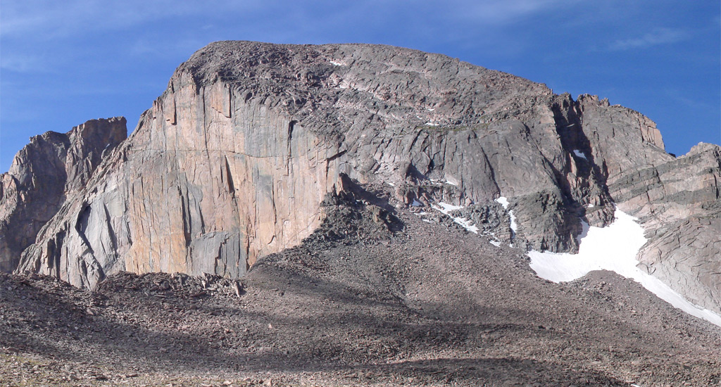
Longs Peak is a prominent 14er in the northern Front Range of the Rocky Mountains, north of Denver. Located in Rocky Mountain National Park, Longs can be seen by car by driving west from the town of Estes Park and into the park on Trail Ridge Road. Want to climb Longs Peak? If so, we need to warn you that this peak does not have a trail to the summit and all climbs are technical, requiring certain climbing skills and equipment. The standard (and easiest) Keyhole Route is a long, difficult climb and some have died on this route. If you haven't climbed many 14ers, please start with one of the easier ones before attempting the mighty Longs Peak.
Elevation 14,259' (LiDAR)
Prev Elevation 14,255'
CO 14er Rank 15 of 53
Range Front
Nat Park Rocky Mountain
County Boulder
Towns Estes Park, Meeker Park
Longs Peak

Photos

360 Pano
360° Summit Pano
pic1
pic2 pic3 pic4 pic5 pic6 pic7 pic8 pic9 pic10 pic11 pic12 pic13
pic14
pic15
pic16 pic17 pic18 pic19 pic20 pic21 pic22 pic23 pic24 pic25 pic26 pic27 pic28 pic29 pic30 pic31 pic32 pic33 pic34 pic35 pic36 pic37 pic38 pic39 pic40 pic41

Climbing Routes

route
Longs Peak - Keyhole Route Standard Route
Difficulty: Class 3
Total Elevation Gain: 5,100'
Round-trip Distance: 14.5 mi
Exposure: High
Rockfall Potential: Considerable
Route-Finding: Considerable
Commitment: High
route  _
Longs Peak - Keplinger Couloir
Difficulty: Class 3
Total Elevation Gain: 5,900'
Round-trip Distance: 16 mi
Exposure: High
Rockfall Potential: Considerable
Route-Finding: Considerable
Commitment: Considerable
route  _
Longs Peak - Loft Route
Difficulty: Class 3
Total Elevation Gain: 5,300'
Round-trip Distance: 13 mi
Exposure: High
Rockfall Potential: Considerable
Route-Finding: High
Commitment: High

Map

Human Verification Required

Trip Reports

  8 Recent Reports Peaks Climbed Added
  Longs via Loft (Keyhole Descent)
By: 1kCardioInA14kWorld
Peak(s): Longs Peak
Added: 8/23/2026
Longs Peak 8/22/2026 8/23/2026 2 
  Longs Peak via Keyhole Ridge
By: infinitealpine
Peak(s): Longs Peak
Added: 8/11/2026
Longs Peak 8/8/2026 8/11/2026 9  15
  Meeker via Iron Gates to Longs via Loft Google Map Included GPX file available for download
By: iceman1212
Added: 7/26/2026
Mt. Meeker
Meeker Ridge
Longs Peak
7/25/2026 7/26/2026 5  5
  Longs - Loft Route
By: salittle
Peak(s): Longs Peak
Added: 7/13/2026
Longs Peak 7/5/2026 7/13/2026 1  13
  Longs Peak Keyhole Route
By: mdehenau
Peak(s): Longs Peak
Added: 7/6/2026
Longs Peak 7/5/2026 7/6/2026 10  8
  Longs Peak via Keyhole Route
By: DrewJHartmann
Peak(s): Longs Peak
Added: 6/23/2026
Longs Peak 6/22/2026 6/23/2026 6  15
  Longs Peak Keyhole summit attempt
By: sunnyqin
Peak(s): Longs Peak
Added: 5/27/2026
Longs Peak 5/16/2026 5/27/2026 3  4
  Moms Day Summit of Longs Peak
By: rlbebr71
Peak(s): Longs Peak
Added: 5/11/2026
Longs Peak 5/10/2026 5/11/2026 6  12
View All 520 Trip Reports

Frequently Asked Questions about Longs Peak

Is Longs Peak suitable for beginner hikers?

No, Longs Peak is a serious alpine mountaineering objective that should never be attempted by beginners. While the trail to the Boulderfield is a well-maintained Class 1 hike, everything above it via the standard Keyhole Route transitions into high-consequence Class 3 scrambling. Climbers must navigate narrow ledges, loose rock, and intense vertical exposure where a single slip or misstep can be fatal. It requires prior experience on less technical peaks, a climbing helmet, and excellent route-finding skills.

Why do climbers have to start the Longs Peak hike so early?

Due to the nearly 15-mile round-trip distance and 5,100 feet of vertical elevation gain, the average summit push takes between 10 and 14 hours. Because the upper technical sections are completely exposed to afternoon lightning strikes, climbers should start their ascent between 1:00 AM and 3:00 AM. The strict safety rule of thumb for Longs Peak is to turn around and begin descending immediately if you have not reached the summit by 10:00 AM, regardless of weather conditions.

How do parking and camping work at the Longs Peak Trailhead?

Parking at the Longs Peak Ranger Station is incredibly limited and typically fills to maximum capacity by 1:00 AM on summer weekends. If the main lot is full, you must park legally along the shoulder of the approach road, adding extra distance to your hike. For accommodation, the park operates the Longs Peak Campground near the trailhead for tents only on a first-come, first-served basis. If you want to camp higher up at the Boulderfield, you must reserve a highly competitive wilderness backcountry permit in advance through the Rocky Mountain National Park Wilderness Office.

What is the Boulderfield on Longs Peak and how does the trail change there?

The Boulderfield is a large alpine basin located at 12,750 feet, roughly 6 miles into the hike, and marks the official end of the maintained trail. From this point forward, the route passes through the Keyhole rock feature and shifts entirely into Class 3 terrain. You must follow painted red-and-yellow bullseyes directly on the rock across four technical sections: the Ledges, the Trough, the Narrows, and the Homestretch. This upper section requires using both hands and feet to scramble up steep, exposed granite.

Additional Longs Peak History