From the upper trailhead (
1), follow the trail north for nearly 0.75 mile to a junction near 11,200'. Turn right, switchback up a hillside, and continue north -
2. Exit the trees at 11,600', stay on the main trail (
3), and turn left
onto the Wetterhorn trail near 12,000' -
4. Continue north to rocky terrain east of Wetterhorn -
5. Zigzag over 0.5 mile through the rocks -
6. After exiting the rocks, hike southwest to a saddle
on Wetterhorn's southeast ridge -
7.
From the 13,100-foot saddle, turn right and begin hiking up the ridge -
8. Ascend yellow-colored dirt to reach more difficult terrain on the upper ridge -
9. Follow a faint, broken trail weaving up through the rocks on the left of the ridge. You'll soon see the next 400 feet of rocky terrain leading to the "Prow," a fin-like tower just below the summit -
10. Gradually ascend below the ridge crest, encountering occasional scrambling sections. One notable obstacle is a rock rib blocking easy passage -
11. Bypass the rib by turning right and climbing a small gully toward the ridge crest -
12. At the top of the gully -
13, you have two options: You can locate a notch on the left, climb through it, and descend slightly on the other side to continue below the Prow and toward the ridge crest -
14,
15,
16. Alternatively, you can climb through the rocks shown in
12 and
13 to reach the ridge crest directly. Once on the ridge, turn left and continue toward the Prow.
Near 13,800', pass the right side of the Prow to reach an open area below the summit block -
17. Notice two notches between the Prow and the summit -
18. Pass through the higher notch (
19), climb over an angled slab, and turn right to see the final Class 3 pitch and crux of the route -
20. Expect occasional loose rocks, but most of the ledges are stable -
21,
22. Just below the summit, you'll reach a ledge/catwalk -
23. Climb directly up (
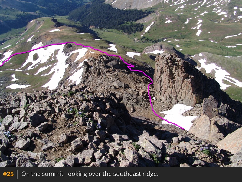
24) or swing a few feet left for easier climbing. Gain the summit and enjoy the views -
25,
26.


 GPX Track File


