Log In 
Photo

Mount Elbert

snow Box Creek Couloirs
Difficulty Difficult Class 2 
Snow Steepness: Moderate 
Ski/Board: Advanced, D6 / R3 / III  
Risk FactorsExposure: Considerable
Rockfall Potential: Moderate  
Route-Finding: Moderate  
Commitment: Considerable  
 
Start10,400 feet
Summit14,438 feet
Total Gain4,150 feet
RT Length10 miles (starting at the end of the 4WD road)
14 miles (starting at the paved TH)
Last UpdatedMay 2025
Show More
Photo
Snow Only Route
This route should only be climbed with consolidated, stable snow, usually in spring or early summer. In mid-winter, many snow routes have frequent risk of avalanche.

Trailhead

From U.S. 24 south of Leadville, take Colorado 82 west toward Twin Lakes. Drive about 4 miles and turn right onto the 24 road. Drive 1.2 miles up a hill to the main trailhead parking area (paved) on the left. This is the lower trailhead and 2WD vehicles should park here. Continue 50 feet past the lower TH and turn left on Forest Service road 125.1B (4WD). From here it's 1.8 miles to the upper trailhead. Walk or drive up the 4WD road to reach the start of the trail.

Along the 4WD road there are several pull-offs and camping spots. Near 0.5 mile there's usually rough section of road but most 4WD vehicles should be able to get past it. Near 1.6mi, cross a small stream. Continue to a parking area with information kiosk at 1.8mi. This is the trailhead.

Route Description

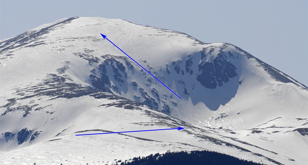
 1,  2, and  3 give you a good look at the Box Creek couloirs. In winter or early spring, you probably won't be able to drive the whole 4WD road to the upper South Elbert trailhead, so park where it's possible and hike up to the trailhead. Follow Elbert's East Ridge Route to reach clearings on the east ridge around 11,600' ( 4). Continue to tree line at about 11,800' ( 5 and  6). Stick to the ridge crest or follow the summer trail if it's clear, leading to a wide saddle at 12,400' ( 7 and  8). This is where you'll leave the east ridge route and head toward Box Creek.

Move to the north side of the ridge and contour left into the Box Creek cirque ( 9). Hike for about half a mile and gain 300 feet in elevation to reach the upper Box Creek area, just below the couloirs. The simplest route—but not always the safest—is to go straight up the center of the slope ( 10 and  11), which is what's described here. Hike to the base of the couloirs and start climbing ( 12).  13 and  14 show the terrain with enough snow for the climb. Between 13,000' and 13,400', the slope averages just under 35 degrees ( 15). Above 13,500', it gets steeper, up to about 38 degrees ( 16 and  17). Around 13,700', it levels out as you aim left toward a broad snowfield at 13,900' ( 18). Finally, head all the way up to the summit ( 19 and  20).
Skiing?

This is the best ski route on Elbert, with many lines to choose from:  10

Notes

Upper Box Creek gets an early and direct sun-hit. Start early.
#1 #2 #3 #4 #5 #6 #7 #8 #9 #10 #11 #12 #13 #14 #15 #16 #17 #18 #19 #20

This page is only available to registered 14ers.com users. If you don't have an account, you can register in the forum.

Log In_

This page is only available to registered 14ers.com users. If you don't have an account, you can register in the forum.

Log In_

This page is only available to registered 14ers.com users. If you don't have an account, you can register in the forum.

Log In_

Caution: The information contained in this route may not be accurate and should not be the only resource used in preparation for your climb. Failure to have the necessary experience, physical conditioning, supplies or equipment can result in injury or death. 14ers.com and the author(s) of this route provide no warranties, either express or implied, that the information provided is accurate or reliable. By using the information provided, you agree to indemnify and hold harmless 14ers.com and the route author(s) with respect to any claims and demands against them, including any attorney fees and expenses. Please read the 14ers.com Safety and Disclaimer pages for more information.

Please respect private property: 14ers.com supports the rights of private landowners to determine how and by whom their land will be used. In Colorado, it is your responsibility to determine if land is private and to obtain the appropriate permission before entering the property.
Heading to a 14er soon? Don't forget the 14ers.com mobile app.
Google Play     Apple App Store