Leave the trailhead and follow the trail west along the edge of Maroon Lake (
1). Pass the lake and ascend the Crater Lake trail for about 1.75 miles until you reach a signed trail junction
. Turn left onto the West Maroon Creek trail, leading to Crater Lake (
2). Follow the trail along the right side of Crater Lake, re-entering the trees. Exit the trees near the lake's southern end, continuing through dense ground cover. Cross a talus field (
3), and follow the trail south for about 0.5 mile to reach the cairned Maroon Peak trail junction
at 10,400' (
4).
Turn right and begin a whopping 2,800-foot ascent up Maroon's east slopes, toward the south ridge. Traverse for approximately 0.5 mile, and near 10,900', the trail turns west and begins climbing the slope (
5). Near 11,600', you'll approach rock outcroppings and small cliff bands (
6). Follow the trail as it angles left into the outcroppings. The climb becomes more challenging, and the trail harder to follow, as you continue up steep, rocky sections (
7). Near 12,900', you'll reach the southern-most point of this route. Turn right and follow a steep, loose trail that climbs toward the ridge (
8). Arrive at the south ridge
, reaching a small notch near 13,250'. Climb through this notch and over a rock outcropping to view the remaining route (
9).
This is a good spot to reassess your climb if weather conditions worsen or if group members are tired. From this point, fast climbers will need at least 1.5 hours to reach the summit, while most parties should plan for 2+ hours. The remaining route demands careful route finding, with potential variations from the route description. As you progress, take your time to study the terrain and look for the safest route possible.
9 and
10 provide an overview of the route, though not all portions are visible from this area.
Follow a cairned trail on the west side of the ridge for about 0.1 mile and turn right to locate a chimney between some rock towers (
11). Climb up the chimney, then turn left and ascend through a large crack (
12). Now above 13,400', continue onto easier terrain where the next section becomes visible (
13). Cross beneath a notch (
14) and climb to a prominent, large white rock band. Traverse across ledges and around a corner where you can see Point 13,753' ahead (
15). Continue on more ledges, to reach ugly terrain before Point 13,753' (
16).
The route becomes significantly more challenging here, requiring precise route-finding. Carefully study the terrain and locate cairns in the distance to minimize backtracking. As shown in
16, two obvious gullies lie ahead, and either one can be climbed to get past this area. Your goal is to ascend about halfway up either gully to reach cairned ledges before continuing left around the west side of Point 13,753'. Drop slightly to the base of a gully and carefully begin climbing its side, mindful of loose rock. If you climb the first gully, exit it near 13,500', traverse left on a ledge to the second gully. Then climb higher to an exit near 13,550' (
17). Continue left along ledges to a robot-shaped rock (
18), then around a corner to reach the broad gully separating Point 13,753' and the summit (
19).
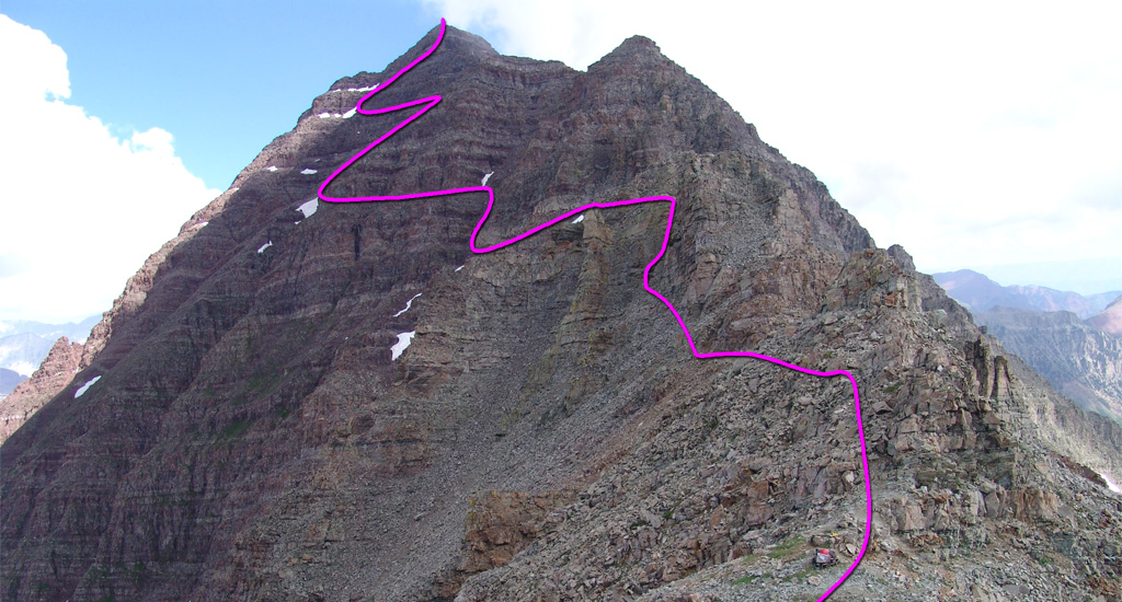
Enter the gully, turn right, and ascend (
20,
21) to its top at a notch
in the south ridge. Turn left and climb onto ledges (
22), continuing to a small slope with exposed ledges. This section includes some of the most exposed and challenging climbing on the route. After passing some initial cliffs, turn right and ascend approximately 150 feet, then traverse left across the slope (
23,
24). On the far side, pass below more cliffs to reach a corner (
25). Turn right around the corner, scramble briefly to the ridge crest (
26,
27,
28), and follow the ridge to the summit (
29,
30,
31).
