Download Agreement, Release, and Acknowledgement of Risk:
You (the person requesting this file download) fully understand mountain climbing ("Activity") involves risks and dangers of serious bodily injury, including permanent disability, paralysis, and death ("Risks") and you fully accept and assume all such risks and all responsibility for losses, costs, and damages you incur as a result of your participation in this Activity.
You acknowledge that information in the file you have chosen to download may not be accurate and may contain errors. You agree to assume all risks when using this information and agree to release and discharge 14ers.com, 14ers Inc. and the author(s) of such information (collectively, the "Released Parties").
You hereby discharge the Released Parties from all damages, actions, claims and liabilities of any nature, specifically including, but not limited to, damages, actions, claims and liabilities arising from or related to the negligence of the Released Parties. You further agree to indemnify, hold harmless and defend 14ers.com, 14ers Inc. and each of the other Released Parties from and against any loss, damage, liability and expense, including costs and attorney fees, incurred by 14ers.com, 14ers Inc. or any of the other Released Parties as a result of you using information provided on the 14ers.com or 14ers Inc. websites.
You have read this agreement, fully understand its terms and intend it to be a complete and unconditional release of all liability to the greatest extent allowed by law and agree that if any portion of this agreement is held to be invalid the balance, notwithstanding, shall continue in full force and effect.
By clicking "OK" you agree to these terms. If you DO NOT agree, click "Cancel"...
Thank you for your detailed descriptions and rememberable photos!
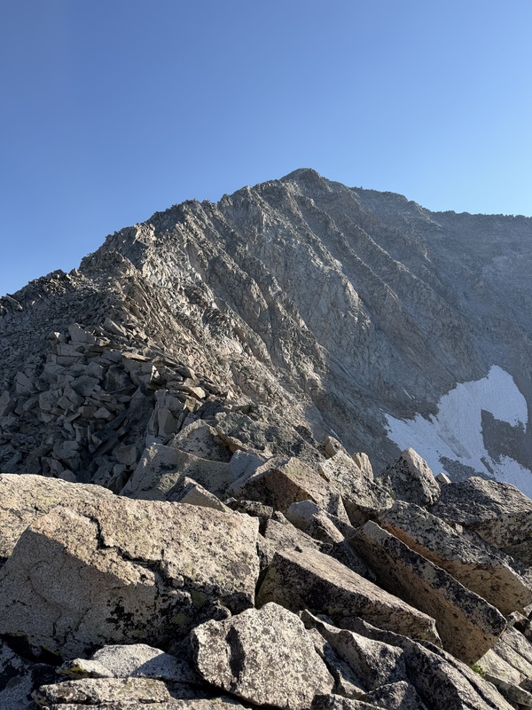
Upper S-ridge with remaining snow visible on east slopes, July 3, 2026
Really I want to add two things:
1. My take on the crux: I went around the left side of the crux (choice B from daway8's trip report - possibly the best review of the crux along the S-ridge). By choosing option B, I had to downclimb into the unpleasant gully anyway. On my descent, I took choice D (the airy move) and while there was exposure, it wasn't as bad on the way down as it looked on the way up.
I assumed the summit push after the crux was class 2 as claimed in other reports, but I found much of the remaining route class 3. Don't get your hopes up or let your guard down
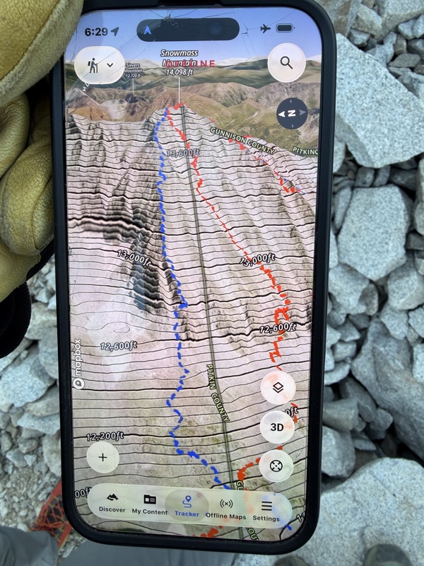
2. What of a 'West Ridge'? I encountered a professional guide and client on their way down as I was headed up the gully to the S-ridge. This guide recommended AGAINST descending the S-ridge due to navigation difficulties, and also strongly discouraged the West Slopes characterizing them as a bowling alley with loose rock. He said his company recommends an alternate route on a ridge adjacent to the West Slopes. I took a pic of his nav screen, and you can see the proposed descent in blue. To access this route, hike from the S-ridge to the summit, and keep going past the entry to the West Slopes, deviating to the adjacent ridge. He mentioned a key move around 12,800' where climbers need to cross west over the ridge (to the right, from the downclimber's perspective) into an adjacent gully to avoid getting cliffed out. Because I lacked a .gpx file for this route (sorry folks!), I actually chose to downclimb the S-ridge. I was thankful for the solid rock, and it wasn't as bad as I thought it would be.
Blue line = unpublished West Ridge, middle red line = West slopes, far right red line = S-ridge
Here are some STATS:
Snowmass Mountain (14,105'), my #53
S-Ridge (both ascent and descent)
July 2, 2026:
Arrived Lead King Basin TH - 6:25 pm
Left TH - 6:40 pm
Hiked 1:14 for 2.07 mi
Arrived at camp 8 pm
July 3, 2026:
Woke - 4 am
Left camp at Geneva Lake - 4:45 am
Little Gem Lake - 5:30 am
S-ridge - 7:10 am
Summit - 9:25 am
Left summit - 9:40 am
Back to Little Gem Lake - 12:30 pm
Back to camp - 1:10 pm
Left camp - 2:30
Back to car at Lead King Basin TH - 3:35 pm
Off the hellish road and back to Marble - 5:00 pm
Total time: 12 hours
Elevation gain: 4450'
Miles: 9.32
Thumbnails for uploaded photos (click to open slideshow):
Comments or Questions
Caution: The information contained in this report may not be accurate and should not be the only resource used in preparation for your climb. Failure to have the necessary experience, physical conditioning, supplies or equipment can result in injury or death. 14ers.com and the author(s) of this report provide no warranties, either express or implied, that the information provided is accurate or reliable. By using the information provided, you agree to indemnify and hold harmless 14ers.com and the report author(s) with respect to any claims and demands against them, including any attorney fees and expenses. Please read the 14ers.com Safety and Disclaimer pages for more information.
Please respect private property: 14ers.com supports the rights of private landowners to determine how and by whom their land will be used. In Colorado, it is your responsibility to determine if land is private and to obtain the appropriate permission before entering the property.


 Preview of S-ridge from FR 315")
 Smoke from nearby fires")
 Camped adjacent to Geneva Lake")
 Upper S-ridge with remaining snow visible on east slopes")
 Summit shot")
 Blue line = unpublished West Ridge, middle red line = West slopes, far right red line = S-ridge")