| Report Type | Full |
| Peak(s) |
North Arapaho Peak - 13,513 feet Mt. Audubon - 13,217 feet Navajo Peak - 13,419 feet Apache Peak - 13,450 feet Ogalalla Peak - 13,154 feet "Old Baldy" - 13,034 feet Paiute Peak - 13,094 feet James Peak - 13,272 feet Parry Peak - 13,367 feet Lone Eagle Peak 11,940 |
| Date Posted | 09/23/2021 |
| Modified | 10/30/2023 |
| Date Climbed | 09/23/2021 |
| Author | illusion7il |
| SOLO Day Hiking the INDIAN PEAKS 58 |
|---|
|
SOLO Day Hiking the INDIAN PEAKS 58
Lone Eagle Peak from Mirror Lake on 10-3-2021 About the Indian Peaks The Indian Peaks Wilderness area is home to 37 ranked peaks. (A peak with at least 300 feet of prominence) However, Gerry Roach published a guidebook that also included additional peaks in the James Peak Wilderness, and a few peaks outside of the wilderness area that fall into the honorable mention category for a total of 58 peaks. 58 just seemed like a special number when it comes to completing a peak list even though some of these peaks are soft ranked (a peak just under 300 feet of prominence). The Indian Peaks lie just south of Rocky Mountain National Park and the area is basically just an extension of park. The ruggedness and remoteness, and solitude of the area is actually quite impressive even though it's within close proximity to the masses of the front range. The Inspiration I have lived in Granby since the summer of 2017, and I have actually had this idea for a few years, but since I was working on bicentennials at that time, I wanted to get that list out of the way first. Lauren got a Indian/James Peak wilderness map by Outdoor trail maps, went through the Roach book, and marked every single peak. Marking all of the peaks on one map really put things into perspective. I looked at the map and thought, "I could probably do all of these peaks in 20 days or less". I finally had the motivation to start the Indian Peaks project. My goal was to go through all of the peaks in the same style that I completed the 14ers, Centennials, and Bicentennials, and that was to do them all solo and complete the routes as single day hikes from the trailheads without the traditional method of backpacking and use of a high camp. With all of the trailheads on the west side, just 35-40 minutes from home, I knew this project would move quickly. Class rating and the YDS YDS stands for the Yosemite Decimal System which is used to give climbers a general idea of the difficulty of the climb, however these ratings can really vary from one area to another. Class 5: Technical rock climbing usually done with a rope and protective gear but sometimes free soloed depending on the climbers comfort level Calendar of climbs This report covers all 58 peaks in the Indian and James Peak Wilderness, some long trail loops, and a few other adventures. I did not follow any GPX routes, however I did use Backcountry Navigator for location, tracking, and navigation. I also included a people stat that says approximately how many people I actually saw on the mountain while I was up there to give a sense of how few people actually climb these mountains. I do not count the people I see on the approach or hanging out in the basin below. Unfortunately, due to never ending smoky / hazy skies this summer many of my pictures didn't turn out very well.
Notes: While driving, I almost hit a moose on my way to the trailhead. Lots of trees down on the Roaring Fork trail. I descended the southwest slopes of Watanga Mountain and for the first time in my life I came across a Cinnamon bear.
Twin Peaks summit viewing "Roaring Peak" Mt. Adams and Watanga Mountain
Notes: On the approach, I ran into two moose near Monarch Lake. The bushwhack up the south slopes of Thunderbolt is rather steep and the route down the southwest slopes of "Blackfoot" isn't much better.
Near the summit of Thunderbolt Peak viewing the Lone Eagle Cirque
Notes: This was my first time ever going to the Devils Thumb Park trailhead. It was a foggy morning and the first clearing I came to, two moose were just staring at me. The route was basically just a long ridge walk. From the summit of PT 11,801, I did a long and difficult bushwhack down the west slope to the Continental Divide trail.
Two moose in a foggy meadow
"Skyscraper" Summit viewing PT 12,660 and Mt. Jasper
Notes: Back up the Roaring Fork trail with all of the down trees. I left the trail at 11,200 ft and proceeded to the summit of Hiamovi Mountain. I located a gully on the south side of the tower that took me up to the ridge and I didn't feel it was any more difficult than easy class 3. I then returned to 11,200 ft where I left the trail and took the north ridge route to the summit of Mt. Irving Hale.
At the saddle of Hiamovi Mountain and "Hiamovi Tower"
"Hiamovi Tower" summit viewing "Martenette" and Mt. Irving Hale
Notes: "Heartbreak Peak" is located in the James Peak Wilderness and Mt. Epworth is located just outside the wilderness area. For this route I decided to use the mountain bike instead of driving up Corona Pass. From Winter Park Resort, I biked up the Buck Creek trail, which is just an old forest road and then joined the Corona Pass road. At 11,400 ft in last group of trees I stashed the bike and hiked up to the summit of "Heartbreak Peak" and returned the same way back to the bike. I then biked on over to Pumphouse Lake and hiked up to the summit of Mt. Epworth via the northwest slope route. The descent down Corona Pass was a cruiser.
Mt. Epworth and Pumphouse Lake
Notes: These peaks are in the James Peak Wilderness. From Berthoud Pass I hiked straight up to the summit of Colorado Mines Peak. It's a long, but fast moving ridge walk all the way to the summit of James Peak. I returned the same way but was able to pass under a few summits.
Near the summit of Colorado Mines Peak
Near the summit of Mt. Bancroft viewing James Peak
Notes: With very poor air quality I decided to get a few peaks done below treeline. An old forest road took me to within minutes of the summit. It's always exciting when you come across a summit register on such an obscure peak.
The amazing summit of PT 10,854 with no view
Notes: Easy bushwhack up the south slope with no trail. The summit register went all the back to 1986.
The magnificent summit of Lonesome Peak with no view
Notes: An old forest road on the southeast slope led me to with just a couple hundred feet of the summit. No summit register for this one. If it weren't for a pile of rocks in the trees, this summit would be easy to miss.
The incredible summit of PT 10,626 with no view
Notes: The Saint Vrain trail moves quickly and it's a short detour to the summit of Meadow Mountain. I came face to face with a moose on the Rock Creek trail on my way from Saint Vrain Mountain to PT 10,583. Then it was off to Caribou hill and go for Klondike.
On the Saint Vrain trail with Saint Vrain Mountain in the distance
Notes: Quick run up and down the East slope
Klondike Mountain summit viewing "Old Baldy"
Notes: So proud of my kids for completing this one. After making our way up La Plata Peak (14,336 ft), and Mt. Elbert (14,33 ft) earlier in the summer, Holy Cross seemed like the next big challenge for kids.
Mt. of the Holy Cross summit
Notes: Just past Monarch Lake, I was hustling along the trail and was startled by a moose that was hidden in the tall vegetation. I immediately took a few steps back, looked up, and there was a baby moose just starring at me. I found myself between mama and her baby which is usually a bad place to be. Mama didn't seem to care but neither one would move so I had to skirt around them on the steep hillside. I left the Gourd Lake trail around 10,500 and bushwhacked northwest to the summit of "Martenette". The route finding was a little complicated to reach the summit of Marten Peak, it took me three or four tries to figure out how to get down from the summit of Marten, and then it was an easy hike over to Cooper Peak. I then picked my way down Coopers' broken east face down to the Gourd Lake trail.
Near the summit of Cooper Peak viewing Marten Peak and Mt. Irving Hale in the distance
Notes: Warning...This is not the most efficient way to complete these peaks as they would be easier accessed from the east side. From the top of Cooper pass, I climbed a steep grassy slope with a few broken ledges straight up to the ridge to the summit of "Ooh La La". I then continued on grassy slopes to Ogalalla Peak. Now it was time to do the Ogalalla to Elk Tooth traverse which didn't seem nearly as complicated as described. I must have missed the class 4 "crux" by dropping down earlier and traversing across a bunch of loose rock. I then located a gully on Elk Tooth's west side that took me back up to the ridge and to the summit of Elk tooth. I repeated the traverse in reverse.
Ogalalla Peak summit viewing the traverse to Elk Tooth
Elk Tooth summit viewing the traverse back to Ogalalla Peak
Notes: A moose was hanging out at the trailhead. This time I went around the south side of Monarch Lake to the Arapaho Pass trail. It was a steep bushwhack up the west slopes of Mt. Achonee, but then it's an easy walk over to "Hopi". From the summit of "Hopi", I picked my way down the east face. I overshot the ascent route on the southwest face of "Iroquois" and had to back track about 15 mins. Then it was a choose your own adventure to the top. Now, I had the choice of returning back to the trail the way I came up, or take my chances descending the the Lost Tribe Lakes route. Roach describes the Lost Tribe Lakes as the "most remote area in the Indian Peaks", and the bushwhack as difficult. I decided to take my chances with the difficult bushwhack. The Lost Tribe Lakes are spectacular and defiantly live up to the hype. The route finding was very time consuming as I kept getting cliffed out, but eventually, I was able to find my way down to the Arapaho Pass trail.
Mt. Achonee summit viewing "Cherokee" Crater Lake, and Lone Eagle Peak.
The rugged Lost Tribe Lakes taken on the descent of "Iroquois"
Notes: Warning...This is not the most efficient way to complete these peaks as they would be easier accessed from the east side. From Pawnee Pass it was an easy hike up to the summit of Shoshani Peak, and what Indian Peaks report would be complete without the infamous Kasparov traverse? Well...kind of...From the lowest point in the traverse, I opted to skip half of the traverse and take some ledges that put me right on the east face of Apache. I then picked my way up to the summit. I then took the standard route over to Navajo Peak via the 4th class chimney. I now had a choice to either return the way I came up which was back across the Kasparov traverse, or drop down the airplane gully of Navajo Peak. This would involve finding a way back up to the Pawnee Pass trail which would add a bit of mileage and elevation gain. I felt like I had enough scrambling for the day so I chose to descend the airplane gully to around 11,400 where I found a steep gully that brought me back up to the Pawnee Pass trail.
Shoshani Peak summit viewing the Kasparov Traverse, Apache, and Navajo Peak
Navajo Peak summit viewing Arikaree, Kiowa, and Albion
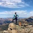
Notes: This was the first time I ever got ten peaks in a day and nine of them were actually ranked. I specifically saved this route for later in the season knowing it would take a good amount of endurance and strength to complete. From the top of Buchanan Pass it was an easy walk over to "Red Deer" and PT 12,277. I then retraced my steps back to the pass and continued on to the summit of Sawtooth and "Algonquin". From the summit of "Algonquin", I took the east ridge down to the west ridge of "Coney Island" (which I had absolutely zero information on). Unfortunately, I was unable to find a route up the west ridge, so I had to retreat and take a longer route up the loose south face to the summit. I then descended the south east face, refilled the water bladder at Coney Creek, and located a large talus gully around 10,400 ft. This was when I knew I needed to hurry and get up to the summits of "Notabon" and Audubon, because I didn't want to get stuck on the Paiute to Toll traverse in the dark. I hustled from Audubon to Paiute, and the traverse from Paiute to Toll was well carined and moved quickly. Reaching the summit of Mt. Toll at 7 p.m. the stress was finally over as I still had about 45 mins of daylight to get over Pawnee Peak and down to Pawnee Pass. Total darkness set in at the top of Pawnee Pass and it was a long hike out. While on the descent, I saw a set of eyes approaching me on the trail I couldn't tell what it was until it got within about 15 feet of me. Turns out it was just a curious fox. I think the most impressive stat of the day was with all of the trail and ground I covered, I literally saw zero people throughout this entire day, not even a tent.
On the traverse from Paiute Peak to Mt. Toll
Notes: From the top of Arapaho Pass it was an easy scamper over to the summit of "Quarter to Five Peak". I then descended south east, cut across the basin, and joined the Arapaho Glacier around 12,600 ft and then continued up to the summit of "Old Baldy". I took the standard route up South Arapaho and made the traverse over to North Arapaho in just 25 minutes. I retraced my steps back to the Arapaho Glacier trail and joined the Arapaho Pass trail where I ran into a big big bull moose that was chewing away at it's lunch.
"Quarter to Five Peak" summit viewing Mt. Neva and Lake Dorothy
Near the summit of "Old Baldy" viewing the Arapaho traverse
Notes: There was a large herd of elk while heading up the Arapaho Pass trail. Getting into Wheeler Basin requires a rough approach, and all the trees down on the Arapaho Pass trail didn't help matters much.
High up in Wheeler Basin
Notes: I've never done a public race before. My 11 year old daughter, expressed interest in running a race so I was able to sign her up the day of the race and I got to be her pacer. At the starting line she literally took off in a full on sprint, but that only lasted for about 5 minutes due to stomach cramps. We kept a steady pace throughout the course. I just couldn't believe it when she crossed the finish line and the announcer said "And we have our first place female finisher!!!"
Podium shot The BIG Finish
Notes: I started high up in Elk Park , and took the south slope to the summit of Montana Mountain, and returned the same way back to the starting point. I then took the west ridge to the summit of Colorado Mountain and retraced my steps back to the car. Then it was off to Monarch Lake for one last peak!
Looking down the north slopes of Montana Mountain towards Elk Park
Notes: Well...The final peak was kinda disappointing due to weather, even though the forecast called for sunny skies. I was really hoping to get some awesome evening pictures and enjoy the final summit but the weather had other plans. From the Cascade Creek Trail, I bushwhacked to the north slope of "Cherokee". The clouds were rolling in fast and when I was about 500 feet from the summit, the snowflakes began to fly, and the visibility started to diminish. I picked my way up the blocky class 3 terrain and tagged the summit during the worst of it. I could see the summit register, but didn't bother to sign it. I stepped down about 10 feet from summit, and popped a couple pictures as I knew I needed to get down quickly. On the hike out by headlamp, I ran into daddy and baby moose. They didn't seem to want to move off the trail so I had to skirt around them while they watched. I got back on the trail and started hustling and nearly ran into mamma moose that was coming up the trail. She didn't want to move either so I had to skirt around her as well. So this was my final farewell to the moose family.
The rugged northeast slope of "Cherokee"
"Cherokee" summit viewing Lone Eagle and Apache Peaks Adventures on Lone Eagle Peak Lone Eagle Peak which is the first picture of this report, has got to be the most spectacular looking peak within the Indian Peaks Wilderness. Unfortunately, it's not even a real peak as it has just 40 feet of prominence. The view from Mirror Lake is iconic, and the peak looks like a perfectly shaped cone, but actually, it's just the start of a ridge line up to it's parent, Apache Peak. The "Solo Flight" route which is listed as class four, is the easiest route to the summit and has the coolest route description of any peak I have ever done. "The view north can be disheartening at first, but at least you can finally see the summit. It is 250 yards north and below you. The summit is not the highest point on the ridge, but it is the farthest north" - Gerry Roach
Notes: Steve and I had this on our bucket list for a few years. The 5.7, eleven pitch climbing route is considered a classic. It rained the night before our climb, and we were approaching this peak with a lot of uncertainty not knowing if the route would be dry. When we reached Mirror Lake we could just barely see a silhouette of Lone Eagle peak. The first pitch was wet as advertised. Even though the route is 11 pitches, most of them move very quickly as a lot of the route is just a scramble with a few few moves here and there. The 5.7 "crux" pitch 10 was amazing and we soon found ourselves on the summit with storms all around us but clear weather above us. Unfortunately neither one of us bothered to take any pictures during the climb.
Mirror Lake and Lone Eagle Peak in the morning fog
Notes: Lauren had never been up Lone Eagle before so we got to go up the "Solo Flight" route on an amazing warm and windless October day.
The descent route with Triangle Lake below
Lone Eagle summit looking up the ridge Loops I believe the Indian Peaks are home to the best trail loops in the business. Keep in mind that most of the trails in the Indian Peaks are rather rugged making it difficult to move quickly. The trails are generally not that well maintained and don't drain well even after it hasn't rained for a while. (not complaining, just saying). All of these loops would be great for backpacking as well. One loop I never got a chance to do was the High Lonesome loop, but half of that loop uses the same trail that the Junco Lake loop uses anyway. Many other loop options exist. I think it would be really cool to combine the Hell Canyon loop with Pawnee Buchanan loop as one big mega route. Some of these loops were completed in the summer of 2020.
Notes: This is my favorite loop of them all and it's also the most rugged. The route over Cooper pass is not trailed so I recommend using GPS. Having done the loop in both directions, I found that going clockwise is a more enjoyable experience.
Cooper Peak
Notes: Warning...This is NOT the most efficient way to do this loop. Most people start from one of the Brainard Lake trailheads, but that would require me to make the long drive around and deal with a reservation system. Starting from Monarch Lake requires a 3.25 mile approach to the start of the loop. One advantage to starting here is you can knock out the highest and more difficult Pawnee Pass first. Technically this loop should be called the Pawnee, Audubon, Buchanan Pass loop.
Heading up the East side of Buchanan Pass
Notes: Caribou Pass has to be one of the coolest passes I've ever done. The long Arapaho Pass trail moves quickly as most of it is run able.
Arapaho Pass
Notes: This loop might actually be the most scenic, with views of the Devils Thumb, Diamond Lake, and towering views of North and South Arapaho peaks.
Devils Thumb Pass viewing the Devils Thumb Trail
Notes: This is probably the fastest moving loop with a good amount of runable trail. In the fall of 2020, Lauren I did this loop counter clockwise, but the amount of down trees made for a rather rough experience. This time we went back and completed the loop clockwise which seems to flow a little better, but either way, you will end on some uphill. All of the route is below treeline, and I recommend GPS as some the trail can be faint and difficult to follow.
Monarch Lake from the Strawberry Bench Trail
Conclusion Impressive peaks and interesting routes, I found this project to be very enjoyable. I'd like to give a special thanks to Lauren for inspiring me and helping me make this dream come true. With all of the trailheads so close to home it was nice to have never spent a night at a trailhead, never set the alarm before 4 a.m., and never make any long drives across the state that often include traffic and construction delays. I enjoy type two fun, and this project had a lot of just that. These routes required hiking up and down many of the same trails over and over again and many of the downed trees were never cleared. A lot of these routes are a bushwhack and it was fun making up my own routes on some of these peaks. I was very impressed by how much wildlife I saw, as I saw far more wildlife in the Indian Peaks in a matter of just a few weeks than I did going through all of 14ers, centennials and bicentennials combined. I didn't think moose stuck together as a family but this one sure did as I ran into them several times. They seemed very tame and didn't seem to care if they were in the presence of a human. Solitude on these peaks is very easy to find as I rarely saw anyone climbing these mountains. Most of these trails are rugged and slow, and I would be content if I never hiked up the Cascade trail again. For more Solo Day Hiking adventures be sure to check out my other reports. Live the Dream...
The sun begins to set on the descent of Mt. Toll |
| Comments or Questions | |||||||||||||||||||||
|---|---|---|---|---|---|---|---|---|---|---|---|---|---|---|---|---|---|---|---|---|---|
|
Caution: The information contained in this report may not be accurate and should not be the only resource used in preparation for your climb. Failure to have the necessary experience, physical conditioning, supplies or equipment can result in injury or death. 14ers.com and the author(s) of this report provide no warranties, either express or implied, that the information provided is accurate or reliable. By using the information provided, you agree to indemnify and hold harmless 14ers.com and the report author(s) with respect to any claims and demands against them, including any attorney fees and expenses. Please read the 14ers.com Safety and Disclaimer pages for more information.
Please respect private property: 14ers.com supports the rights of private landowners to determine how and by whom their land will be used. In Colorado, it is your responsibility to determine if land is private and to obtain the appropriate permission before entering the property.