| Report Type | Full |
| Peak(s) |
Engelmann Peak - 13,370 feet Robeson Peak - 13,129 feet Bard Peak - 13,641 feet Mt. Parnassus - 13,580 feet Woods Mountain - 12940 |
| Date Posted | 09/05/2018 |
| Date Climbed | 08/25/2018 |
| Author | supranihilest |
| Bard Quintet from Ruby Gulch: Not a Diamond in the Rough | |||||||||||||||||||||||||||||||||||
|---|---|---|---|---|---|---|---|---|---|---|---|---|---|---|---|---|---|---|---|---|---|---|---|---|---|---|---|---|---|---|---|---|---|---|---|
|
This weekend was my climbing partner ChrisBam and his wife Jami's birthday weekend (their birthdays are two days apart), and that of course necessitated drinking and eating a lot, and eating and drinking a lot, both in that order and in the opposite order. This also necessitated doing something close to home that was relatively short so I could make it out for aforementioned drinking and eating and eating drinking both Friday and Saturday and not feel like a total wreck afterwards, though not feeling like a total wreck was not, unlike everything else, a necessity. I also wanted to do something I hadn't done before which got me looking towards 13ers again. I eliminated the remaining 13ers in Rocky Mountain National Park because I wanted to do big linkups of those and wouldn't have time for that, same for a pair of Tenmile linkups that would net me every 13er; most of the Indian Peaks was either too technical and time consuming, was reserved for later climbing (for example, I've failed on Audubon's southeast ridge twice in winter and I refuse to not do it in winter as a consolation prize), or is subject to closures (Arikaree and Kiowa); the James Peak Wilderness 13ers are best done with a shuttle, which I didn't have; I don't have a 4WD vehicle for some of the peaks south of I-70; etc. etc. What's a lad to do when he has a million excuses not to climb anything? After searching high and low for something, anything that would be doable half hungover in a few hours I settled on doing the Bard group of 13ers - Engelmann Peak, unranked Robeson Peak, Bard Peak, and Mount Parnassus, plus 12er Woods Mountain - in a loop from Ruby Gulch. I knew next to nothing about these peaks except that Mount Parnassus, my first ever winter climb in December, 2015, royally whooped me at the time. This wasn't winter though, and that was three years ago and I'm much stronger now so it should be easy enough. Finding information about the loop was a bit trying though, and I got much of the beta I needed from rajz06's and goldenite's awesome trip reports on the same loop. I was quite surprised by the lack of information on these Front Range peaks so the purpose of my trip report is twofold: document the good times in the mountains and supplement the available beta on these peaks. For most of the hike I was strongly considering writing a route description for this seemingly easy loop but after having a terrible bushwhack coming down Woods Mountain and not being confident enough to write about that specific area I decided not to. I might re-climb Woods by itself to gather the right info and photos since everything up to that point I could write up no problem. Anyway, on to the fun! The night before (Friday, August 24, 2018) the Birthday Bashers met at 4 Noses Brewery in Broomfield. If you haven't been there I won't do the ironic thing and tell you not to go, because 4 Noses is the best brewery around. Objective fact. Dog friendly, rotating food trucks, cheerful staff, and of course some of the finest beer I've ever had. Having been born in and lived in Wisconsin most of my life that's a high bar - we Wisconsinites know our booze. I was out pretty late and while I kept the drinking to a minimum (not the eating though) any amount of alcohol does bad things for my exercise performance. That combined with about five hours of crappy sleep meant I was tired in the morning but I dragged my butt out of bed and drove to Ruby Gulch anyway, since the commitment was pretty low. I wasn't sure at all what the road to the trailhead was like and there's scant info about it so I was pleasantly surprised to find it was about a 2 out of 6 on Mr. Middlebrook's road difficulty scale; dirt but very well maintained, no 4WD or high clearance required. There's a small parking area for maybe five or six cars across from the Urad Mine wastewater treatment plant. A tenth of a mile or so past the parking area the road splits and the left, gated branch is where I would say the hike really begins.   The road continues through the forest for a good distance, maybe a mile or so, to another junction. At this junction I took a left towards Engelmann Peak. I'm still unsure where the right branch goes, perhaps it meets with the old road segments coming down from Woods Mountain. You also get your first views of the basin as you hike along the road.
I passed some old mining junk (site note: does anyone know why this crap is able to just be left strewn about?) and a hand-built log bridge. I thought the bridge would take me where I needed to but just to its left was private property and a small cabin; clearly not the way to go.   I continued on until I found a collapsed hillside, familiar from the other trip reports. The creek comes down here, and from here I turned left off the road, into the trees, and followed a faint trail as it began to ascend steeply up the hillside. For those reading this for beta, you might also be able to go directly up the hillside in front of you before turning left, but it likely doesn't lead anywhere that staying low at the creek wouldn't.
I kept on following the trail alongside the creek until Engelmann came into view.  With glimpses of Engelmann now visible I had to pick and choose one of four gullies or a rib on either side of said gullies.  I didn't realize it at the time but I was already long past Gully #1; the drainage I was following drained Gullies #2, #3, and mainly #4. I continued onward and hit yet another junction, this time staying right. The left branch was considerably steeper and had cliffs on its north (left) side that looked difficult to bypass easily. This also lines up with what is shown on a topo map when considering that the left branch goes to Gully #2 and the right branch goes to Gully #3. Gully #3 looked to be the least steep overall, as well as the least guarded by steep terrain at its mouth.  By now the terrain was quite steep and there was no trail. Attempting to gain as much elevation as possible as quickly as possible, all while keeping it at Class 2, I weaved through small outcroppings and over extremely loose, sandy patches as I pushed towards treeline. The outcroppings eventually gave way to tundra or large jumbles of loose rock, generally funneling towards the center of the gully. I still wasn't sure which one I was in at this point (in hindsight it was #3) but it mattered very little, they all went to the summit ridge and this one seemed easy enough. It was good I was in this one since the others all seemed to have their problems: comments on the other trip reports state that Gully #1 is "for the goats"; Gully #2 seemed well guarded by steep, loose outcrops; I had no idea where to enter Gully #4 and it's by far the furthest from the summit anyway, so Gully #3 seemed like a perfect fit given all that. That is not to say Gully #3 is the only sure way, just that it naturally felt best.   The view of Mount Parnassus and Woods Mountain were sublime from the gully. Bard Peak was blocked by the next rib to the south.  As I hiked up the gully the steepness relented only slightly, but the terrain got rougher. Eventually I moved to the rib to climber's right, since the gully turned into nothing but broken granite blocks with all the soft, supportive dirt and grass worn away by erosion and countless avalanches. I was off my intended GPS track up the rib between Gullies #1 and #2 by quite a ways which meant a bit more hiking to get to the summit from the summit ridge but the ridge was nearly flat and went by quickly compared to the steep, loose gully I just struggled up.   I got to the summit and, checking my watch, discovered I had done just over 2,900 feet of gain to that point. So close to 3,000! I contemplated the best way to get that extra 100 or so feet, what with three sides of the summit being super loose and steep dirt and the fourth being the nearly flat summit ridge. Ultimately I simply walked up and down a short and steep but stable section (maybe the only one nearby) 3 or 4 times until I hit 3,000 feet, whereupon I could move on with the rest of my day.  I also discovered the true summit register which had been blown/thrown/moved partway down the slope, away from the cairn. The white bottle in the photo above is the register, and the blue bottle, which itself is stuck inside a hiking boot, is a wonderful memorial to a man's dog, Sir Alphonse Boudreaux "Rocky Dog" Rockachaw. In the bottle were a number of photos of Rocky Dog, some of Rocky's personal effects, and several condolence cards to his human, Dave.
If you go up Engelmann Peak, please return Rocky Dog's memorial to its original state. There were several summit sign-ins on one of the cards and though they offered condolences of their own I feel like this is a special memorial that should be preserved as best as possible, so please don't trash it. From Engelmann's hard-won summit I had views of the entire remainder of the hike. Robeson Peak didn't look too bad but Bard and Parnassus were both pretty high and I couldn't tell exactly what the best way across their connecting ridge was from my vantage point.  Robeson Peak came and went quickly, given that it's a very simple Class 1 hike across terrain I already covered. I was getting pretty tired though and was moving slowly. Usually the relatively little work I'd done so far wouldn't wear me out that much but the party the night before left its mark. I contemplated escaping back down the gully from here, which would be the last remaining escape possible until the Parnassus-Woods saddle, but I had made it this far, didn't want to go back down the gully, and didn't want to have to come back up it on a return trip either. The view of the hike to Bard from the summit of Robeson gave away that it was all Class 2, it was just kinda high up there. It's craggy features were enticing though, and I had good weather so I kept on going.  Distance-wise it was shorter from Robeson to Bard than it was from Engelmann to Robeson, and even the elevation gain up Bard wasn't too bad. It was certainly nowhere near as bad as Engelmann's gullies, and for that I was and am very thankful. Wrapping slightly around the mountain to the southeast I soon found myself on the summit, looking across the ridge to Parnassus.  For those reading this report for beta purposes, note that this is your last escape chance before the Parnassus-Woods saddle that gets you back to Ruby Gulch and the only escape chance that doesn't require major elevation gain in the process. The downside is you'll have to go back down Engelmann's gullies. If you thought they were fun coming up you're in luck but for us sane folk the prospect of going back down the gullies is less than palatable. Anyway, if weather or exhaustion or anything is saying turn around this is the place to do it. Quickly making my way down to the saddle without a trail, I found one of the only places on this hike where one could maybe find Difficult Class 2. The rest of the way up to Parnassus contained blocky rubble piles that were easy to keep to said Class 2, though this section could also have been kept to Class 1, mostly on tundra, if I had dropped down a few hundred feet further before traversing across and up. That wasn't necessary and might have even been more work than just working my way through the rocks.       I found Parnassus' summit pretty unremarkable, like the rest of the peaks I had already climbed. There just wasn't a whole lot going on and the tire factor was still there, though hadn't gotten worse. Looking over to the final peak of the day, Woods Mountain, was a bit discouraging since it was a YUGE drop to the saddle and then an equally YUGE climb to the summit. With a hop, skip and a jump (I wish) I was on my way. It's not like there was anywhere else to go.   Again, for beta purposes, there are escapes both north into Ruby Gulch and south into Watrous Gulch from the Parnassus-Woods saddle. The former takes you back to your car but you likely won't see anyone until you're back on US-40. The latter is likely to have people nearby (or at the Herman Gulch trailhead to the west) if you need immediate assistance, and is directly on I-70, but takes you in the complete opposite direction of your car. The remaining hike up Woods went by quickly given the gentle terrain and semi-established trail, though the summit visible for the entirety of the hike is merely the east summit and seemed ever so slightly shorter, by just a few feet tops. I went over to the west, higher summit in just a few minutes, took a photo of part of the ridge descent, then scooted back to the east summit so I could begin my way back down the final descent. 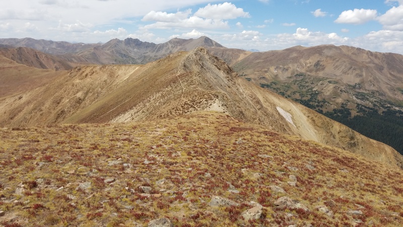   I knew there was an old mining road on Woods Mountain's northeast side and I figured it would be a longer descent due to the switchbacks, but easier than simply descending straight downhill. That turned out to be exactly the case, at least until the road disappeared next to an out-of-place cairn, having bypassed some old mining junk along the way. 
 Now here's where things went terribly wrong. I couldn't see any more road after this, whether it was because it was overgrown or whatever reason. I was a little unsure where to go anymore or whether I'd find anything obvious, and had basically two choices: go southeast, towards Bard, on open, shallow slopes, but away from my intended direction of travel; go east or northeast, towards Engelmann and my car, but descend into the forest. It seems like the choice here was easy, go with the former. So I of course did the exact opposite. I walked northeast for maybe 30 seconds, mostly to explore, and found what looked like a great trail through the trees. I was immediately convinced to continue in that direction instead of going southeast, away from where I wanted to go.  The trail actually proved to be pretty good for the most part. It meandered through the trees, sometimes being lost, but mostly being obvious and easy to locate again where it petered out. I followed it quite a way until it hit a wall to my left, and then it started to go down. Waaaayyyyy down. The terrain got steeper, and then steeper, and somehow even steeper still. The trail disappeared completely and I was hiking down what felt like a 50 degree slope through the trees, now thick and with plenty of deadfall. I had passed a waterfall early on in the hike and was worried about the terrain getting too steep to continue on, or cliff out, or me slipping and tumbling down the hill bouncing off the trees like a pinball. I was pretty committed though, so I just kept on hiking down the slope.   I could hear the rush of the stream below getting louder quickly, still worried about the waterfall from before. It'd be perfect to descend for an hour through this nonsense only to cliff out. I was pleasantly surprised, however, to come out directly at creekside. Thank god. It was a major relief to finally be on flat ground instead of carefully bracing myself against trees to keep from falling.  I had to go upriver a little to find a good spot to cross, and from there it was a short bushwhack to the road I had come in on. I was something like half a mile from the gate at worst. My trek through the woods hadn't really paid off, in my opinion, but at least it was over and I could relax a little. Next time I would go south from the cairn high up on Woods and attempt to find more road or simply a less steep path down the ridge. That seems to be what goldenite did; rajz06 and I seem to have done it the hard way. As it is this worked "fine" but was less than ideal and may have actually taken longer on account of how carefully I had to pick my way down. A zippy and much less stressful hike back to the car and I was on my way back to Boulder for birthday shenanigans part deux! StatisticsClimbers: Ben Feinstein (myself)
Splits:
¹This was spent doing some re-ascent to hit 3,000' gained, as well as looking through Rocky Dog's memorial. Thumbnails for uploaded photos (click to open slideshow): ")
")
")
")
")
")
")
")
")
")
")
")
")
")
")
")
")
")
")
")
")
")
")
")
")
")
")
")
")
")
")
")
")
")
")
")
")
")
")
")
")
")
")
|
| Comments or Questions | |||||||||
|---|---|---|---|---|---|---|---|---|---|
|
Caution: The information contained in this report may not be accurate and should not be the only resource used in preparation for your climb. Failure to have the necessary experience, physical conditioning, supplies or equipment can result in injury or death. 14ers.com and the author(s) of this report provide no warranties, either express or implied, that the information provided is accurate or reliable. By using the information provided, you agree to indemnify and hold harmless 14ers.com and the report author(s) with respect to any claims and demands against them, including any attorney fees and expenses. Please read the 14ers.com Safety and Disclaimer pages for more information.
Please respect private property: 14ers.com supports the rights of private landowners to determine how and by whom their land will be used. In Colorado, it is your responsibility to determine if land is private and to obtain the appropriate permission before entering the property.


