| Report Type | Full |
| Peak(s) |
Ellingwood Ridge - 13,222 feet The Sawtooth - 13,780 feet Torreys Peak - 14,272 feet Grays Peak - 14,275 feet Quandary Peak - 14,272 feet Mt. Bierstadt - 14,066 feet Mt. Blue Sky - 14,268 feet "East La Plata" - 14,186 feet La Plata Peak - 14,344 feet Mt. Buckskin - 13,871 feet |
| Date Posted | 08/11/2020 |
| Date Climbed | 08/08/2020 |
| Author | daway8 |
| 4 Classic Ridges: Ellingwood, Kelso, Sawtooth and Quandary West Ridge (plus Buckskin) |
|---|
|
Ellingwood Ridge, Kelso Ridge, the Sawtooth Traverse, Quandary West Ridge – all these names get thrown around a lot on this site and attract a lot of climbers who are interested in something a little more challenging than your average stroll up a 14er with your hands in your pockets kind of route. There’s already a ton of beta out there on these routes so I skipped doing individual trip reports and am instead doing one large combined TR with some of the typical elements of my other trip reports but a greater focus this time on comparing/contrasting these classic routes plus the lesser known Buckskin-Democrat traverse. 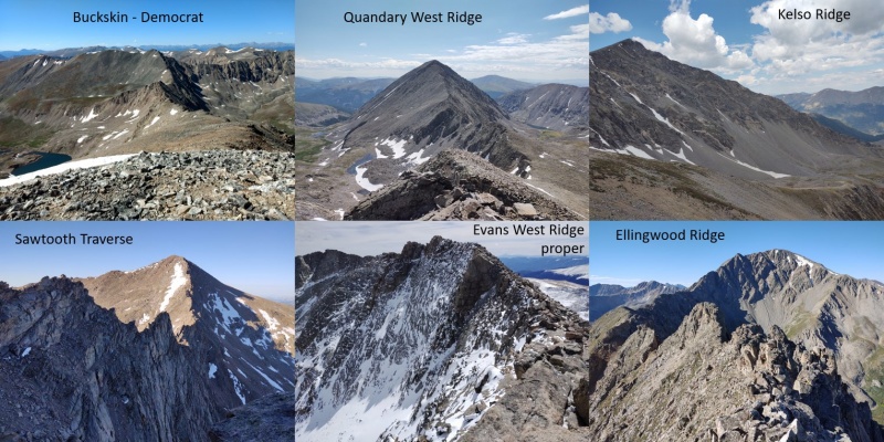
In this trip report you’ll find: Part I - Comparisons
Part II – Route Notes/Photos
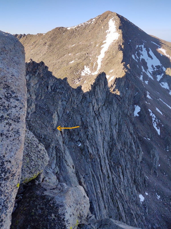
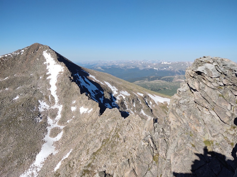
Look for large bold headers to quickly find the sections of interest. Part I is heavy on text as I compare the routes. For pictures jump to Part II Part I - Comparions Route Stats and Overview: Sawtooth Traverse: Guanella Pass – Bierstadt – Sawtooth – Evans – Evans West Ridge descent to Guanella on July 3, 2020 Standard route stats: 10.25mi, 3,900ft My version: 11.3 miles, ~4,470ft (includes a few detours) My time: 10h 26 min (lots of playing on rock features, hanging out with mountain goats, etc) Evans West Ridge – ridgetop variation: ~same distance, maybe an extra 100-200ft gain, lots more fun (I did this on 3/16/2020 – perfect end of winter hike) Quandary West Ridge: Blue Lakes – Quandary West Ridge – Fletcher – Blue Lakes on July 18, 2020 Standard stats: 4mi, 2,650ft My version: 7.3 miles, ~3,470ft My time: 9h 11min (went slow, teamed up with some relative newcomers to class 3 routes) Kelso Ridge: Grays Peak Trailhead – Kelso Ridge – Torreys – Grays – Edwards – McClellan – Edwards – GP trailhead on August 1, 2020 Standard stats: 6.75mi, 3,100ft My version: 11.4 miles, ~5,400ft My time: 11h 8 minutes (lots of time spent on sunrise photos and playing on rock features) Ellingwood Ridge: La Plata Peak trailhead – Ellingwood Ridge – East La Plata – La Plata – standard NW Ridge descent to TH on August 8, 2020 Standard stats: 9.5mi, 5,900ft My version: 10.5 miles, ~5,500ft (stayed high for much of the route - I think that's why my elevation count is lower) My time: 16h 10 min (tons of time spent off course going up all the high points on the first half, then lots of time spent route finding in the second half, then almost burning out, then pressing on) Buckskin – Democrat Traverse: Kite Lake – Buckskin – Democrat – Cameron – Lincoln – Bross – South Bross – Bross – Kite Lake on September 2, 2019 Standard stats: 5.2mi, 3,100ft (not officially defined – these are stats for Buckskin-Democrat loop) My version: 10.22mi, 4,800ft My time: 10h 50 min (lots of time spent documenting the Buckskin traverse then tried to blow through Decalibron too fast and crashed for a while) Difficulty ranking (easiest to hardest) Evans West Ridge proper: Pretty much a class 2 stroll just above the standard route with maybe a few isolated, easy class 3 moves but far more scenic and interesting (see other rankings below). Buckskin-Democrat: perfect intro to ridges; largely class 2 with some easy class 3, a few harder options you can take or bypass). Quandary West Ridge: great class 3 primer; only a couple difficult class 3 sections. Might make newbies pucker, but likely to disappoint those looking for sustained action. Sawtooth Traverse: A step up in terms of bonus options available with a couple really nice towers that you can bypass or scramble up (moderate-difficult class 3). Kelso Ridge: Greater variety available, lots of optional features just off main route. Fun mini version of the Knife Edge (great way to get a sneak preview of Capitol’s infamous Knife Edge – if you can’t handle this miniature version then stay away from Capitol!) Ellingwood Ridge: The ultimate climber’s playground – you can literally spend all day climbing up and down an enormous variety of features, from towers to cliff faces to a leap of faith, narrow exposed ledges, gullies, highly exposed traverses, etc. While a class 3 route can be found you can easily wander into class 4 and 5 terrain especially if you try to stick to the ridge top. DON’T MESS WITH THIS ROUTE if you’re a newbie! Please do some of the above routes before trying this one or you may get yourself into trouble. Be warned that if you take advantage of all the best scrambling that there is far more of it than on any of the other routes described here and so you may be surprised at how much more you tire out with prolonged class3+ scrambling. Exposure ranking* (least to greatest) [*ridges by definition are exposed – this is given more in terms of “felt” exposure or potential “fear factor.”] Buckskin-Democrat: For the most part if you just stay on top of the ridge the felt exposure is comparatively minimal for a ridgeline. Unless you intentionally walk over to the very edge you’re not going to often “feel” exposed unless you have a major problem with heights. Quandary West Ridge: During the couple harder class 3 moves, depending on the exact lines you pick, you may briefly get enough exposure to make you sweat. Generally speaking not ‘fatal’ exposure (unless you land on your neck) but you might break some bones if you’re careless and get into greater trouble if you wander a little too far off route. Sawtooth Traverse: Most of the standard route has a very low “felt” exposure but you can get some pretty sweet heart pumping exposure if you go to the top of the optional towers and stand on the edge. Also, the exit (going from Bierstadt to Sawtooth) is a sloped ledge with fatal exposure – if you’re afraid of heights this might really freak you out. The technical difficulty is very low but the potential fear factor could be very high. Kelso Ridge: Again much of the standard route has a fairly low “felt” exposure but there’s a good deal of exposure to be had if you play around on the optional features (including one small but fun little tower near the start of the ridge). Obviously the primary exposure point is the mini Knife Edge – trivial compared to the exposure on Capitol but people have been known to crawl across this mini version with as much trepidation as the real one – perhaps in part due to the fact that a fall here could be fatal... Ellingwood Ridge: If you take/find the class 3 route the entire way then much, but not all, of the felt exposure can be avoided. But there are a few spots where you’ll be hard pressed to avoid it. Alternately, if you desire exposure there are a boatload of options to get your heart pounding. There’s a great little leap of faith (maybe 4-5ft gap over a drop of perhaps 8-10ft - see GPX waypoint), lots of towers and narrow skinny humps, at least one dramatically exposed narrow ledge above the typical route, and all sort of other options to stare death in the face if you choose to do so. Evans West Ridge proper: What?!? Evans topping out Ellingwood Ridge on exposure ranking?!? No, I’m not on drugs – I was just hiking an extra 20-40ft or so above where the masses go. If you leave the main trail and pop up onto the very top of the ridge there are some portions where you’ll encounter some of the most epic exposure out there – about on par with Capitol’s Knife Edge in terms of the felt exposure (though only on one side). Mathematically the drop is less than the Knife Edge but visually it’s very stunning especially since the bending of the ridge gives you a better view of the drop than you get on the Knife Edge. Bonus points when still covered in snow. Perhaps only the far side of Uncompahgre has a more visually stunning extreme drop off. Route Finding* (easiest to hardest) Evans West Ridge proper: Route finding doesn’t get any easier than this – just walk up to the highest spot on the ridge and then you can pretty much see the whole thing. Stay on top or drop right to the standard trail if you need to. Buckskin-Democrat: Pretty straight forward with much of the route visible the whole time (though there is a bump in the center that blocks the view part of the time). There are couple spots where you have maybe 2-3 significant options in terms of going over, around or through some large rock features but it’s very easy to backtrack if needed (see linked TR at the start of Part II if you want a few tips). Sawtooth Traverse: Again, a pretty basic connect the dots from Bierstadt to the Sawtooth. There are a couple options on the second half in terms of going over/around/etc but the most important route finding piece is making sure you line yourself up with the exit ramp up to the Sawtooth. Highly recommend studying the pictures in advance since at first glance that ramp might not look like the obvious choice for a safe exit. Kelso Ridge: The trail for much of this is pretty well defined and/or easy to spot. There are a few features where there are a couple choices on how to go around but the ridge isn’t that wide so there isn’t too much room to wander too far off route. Quandary West Ridge: Overall this route is pretty simple but in the regions of the couple interesting class 3 sections it’s somewhat easy to wander off course and into sketchier terrain. This ridge has a slightly more spread out feel to it than Kelso, which is why I ranked it higher but they’re about a toss up. If you get uncomfortable, try backing up and taking a different line. And you might have some issue navigating up out of the valley onto the ridge especially since snow tends to linger a long time in that valley. Ellingwood Ridge: Having done over 100 14ers/13ers I think I can say this was the only time when route finding was a very major issue for me. Of course that’s largely because I barely paid attention to the route description and only occasionally glimpsed at the GPX files I had loaded since I was having too much fun with all the awesome scrambling. With that said, if you download the 14ers.com app and a set or two of GPX files and pay close attention to them you probably won’t have too much trouble, though you’ll likely have to pause frequently to look things over. But if you listen to the siren’s call and are lured up onto the ridge proper – BEWARE! You can rapidly and easily get yourself into life threatening terrain! And since the harder route finding is on the second half of the ridge (where many people drop way down below to skirt around it and then climb back up) it’s easier to find yourself getting tired and tempted to just push through sections that you might otherwise avoid and then find yourself in extremely ugly terrain. Remember this cardinal rule: DON’T GO UP/DOWN ANYTHING YOU CAN’T DO IN REVERSE! Also note that if starting in the dark (which is a good idea given how long/involved this route is) there can be a couple spots getting to the ridge where it’s easy to miss the trail (see Part II). Fun Factor* (in order of increasing fun) [*Obviously highly subjective and depends on your personal preferences but this can give you some ideas] Quandary West Ridge: What was there was really fun but there just wasn’t enough of it, and no where near the variety of the other routes in this report – lacking in cool towers, epic exposure and other fun features. Felt like a lot of work for not enough fun. But still a MASSIVE step up in fun factor as compared to the standard route up Quandary and easily much better than your standard class 2 routes on any of the 14ers so still a worthwhile route to do. Check out the pictures in Part II if you want a better feel for this. Buckskin-Democrat: Though a very easy route and not very dramatic overall, it felt like there were a few more options on picking routes and simple scrambling features than what Quandary’s West Ridge had, even if none of the features were as challenging as the couple that are available on Quandary. Sawtooth Traverse: The optional towers are the highlight of this traverse – without them I think this would be at the bottom of the list. Evans West Ridge proper: This one was so surprising since I’d passed so very close on other trips never realizing how much neater it was just a little bit higher. Though the scrambling features are very small and very easy their proximity to epic exposure gives them a more exciting flavor and the minimal extra effort required vs the standard route means the fun isn’t drowned out by a long slog to get there and back. Kelso Ridge: A mini Knife Edge, a small exposed tower, the white wall and white fin – the features are more interesting and greater in number than the previous routes. But still it seems to end too soon and lacks scale (a “mini” Knife Edge is good but just not the same as Capitol…). Ellingwood Ridge: This route doesn’t even hardly belong on the same list as the others. Now granted you could really knock the fun factor rating way, way down if you took the easiest possible route. In fact, given the huge, painful push just to initially gain the ridge and the major overall gain (~6k) you could make this a somewhat miserable slog especially if you’re not in shape. But if you’re in good condition and up for some scrambling this truly is the ultimate climber’s playground! You’ll miss several of the most top notch features if you take the easiest route. Up on or near the ridge top you’ll find the leap of faith, highly exposed traverses, dramatically exposed tiny ledges, towers and fins and cliff faces offering challenges for both rookies and perhaps the most veteran climbers out there. Parking issues* (in order of easiest to hardest to get a spot) [*Note that COVID seems to have swelled the crowds for 2020 – these rankings might change once we’re fully into post-coronavirus days…] Sawtooth Traverse/ Evans West Ridge proper: Wait, Guanella Pass takes the spot for easiest parking?!? I didn’t say best – just easiest – simply because there’s so much room between the two lots and all the roadside parking. Plus the no camping signs seemed to have scared off a lot of overnight folks even on the 4th of July weekend (the signs show no tents and no campfires but stoves allowed – so there’s a gray area about sleeping in your vehicle, which I did the evenings of July 2 and 3 without issue). Buckskin-Democrat: Kite Lake also on the easy side?!? Yep, same argument as above – not the greatest setup – only one lot but tons of parking along the road. Just get there as early as possible to shorten the walk. Quandary West Ridge: I hesitate to put this in writing because the Blue Lakes Trailhead seems comparatively undiscovered by many, though still quite popular. As it becomes even more popular this is going to be a major bottleneck as roadside parking up to the lot just isn’t going to be feasible. During corona-days you might want to arrive the night before and sleep in your vehicle for the best chance at being sure of a spot. Ellingwood Ridge: I was surprised by this one. The La Plata Peak trailhead is right off the main road so there are zero access issues but I arrived on Friday Aug 7 at 10pm to find the lot already maxed out. Managed to barely squeeze in between the last car and the parking sign. No decent overflow options. Kelso Ridge: The Grays Peak Trailhead is developing an ever worse reputation. Rather than deter people, the 4WD road seems to often just attract a more rowdy batch of folks and causes people to foolishly ditch their cars at some of the worst possible spots along the road. I arrived at the upper lot at 8:30pm on Fri Sept 31 and got one of the last remaining spots. Part II – Route Notes Buckskin - Democrat If you want to see an extremely detailed breakdown of the Buckskin – Democrat Traverse, see my previous trip report here: Buckskin to Decalibron traverse plus South Bross Evans West Ridge proper For an overview of the Evans West Ridge proper that’s not as detailed but has some good photos see this previous TR: 4 Peak Evans Ridge Route at end of winter Sawtooth Traverse There’s not a huge amount that needs to be said about this route given the documentation already out there – the standard route up Bierstadt is a no brainer and it’s pretty obvious where to drop down and go over to the Sawtooth. As stated above, the key to this route is to make sure you recognize that exit ramp to get up to the Sawtooth. You might think you see some easier options than that but will likely get yourself in trouble if you try any other way off the ridge, unless you’re up for technical climbing. My other tip, if you’re comfortable on class 3 terrain, is don’t stick to the standard route – go scramble up to the high points on the ridge since those are the best parts (but if this is your intro to class 3 you may find the standard route plenty enough for you). The easiest way down if you’re coming from Guanella is to follow the Mt. Evans West Ridge from Guanella Pass description down into the valley through the willows. There’s a pretty good path through the willows these days but it’s not a bad idea to download the GPX tracks since, if you do happen to lose the trail in the willows, it can be quite a real pain. Below are some photos to give a flavor of this fun but short ridge. 


Quandary West Ridge: One key gotcha on this route is that if you start in the dark it’s easy to miss the turn uphill to the right and instead blunder into the revegetation area along the lake. It’s also not 100% obvious where best to come up out of the valley and gain the ridge especially since snow fields seem to linger for a long time in this valley. Study the class 3 sections carefully before you go – they can be very intimidating to the uninitiated but they’re not as bad as the photos make them look. 


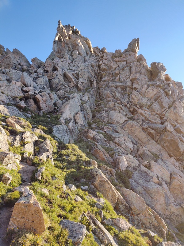
Kelso Ridge: This is probably going to be the most crowded of any the hikes on this list since you start and finish on an extremely popular trail (in a normal year when the road up Mt. Evans is open that would be a competitor but the West Ridge from Guanella Pass route down is much less crowded). However, as soon as you leave the main trail and head to Kelso Ridge you have dramatically higher odds of there only being a few people around if any. This is another route where I’d encourage those comfortable with class 3 terrain to go ahead and play around off route – the standard route is very short and so you can get away with multiple detours along the way if you’re in decent shape. 


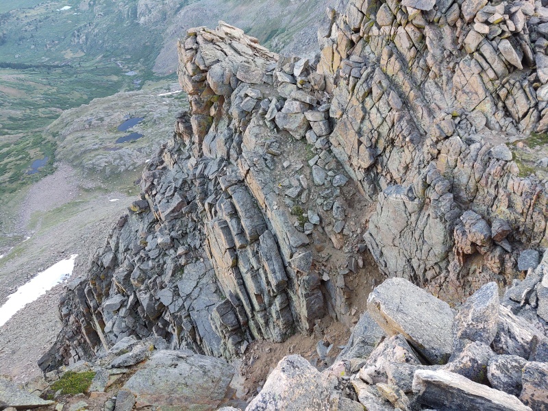
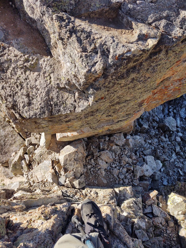
Ellingwood Ridge: Given that this is a long and involved route without a lot of good bailout options and on which you probably especially don’t want to be caught in a storm it’s a good idea to start before sunrise and on a day when the forecast is as pristine as possible. But if you’re starting in the dark then it’s not a bad idea to download the GPX file for this hike to help make sure you don’t miss your turns. Both the initial turn off the main trail and the turn right up along the stream are very easy to miss in the dark and given how very, very steep and long the approach up to the ridge is you don’t really want to have to bushwhack up the steep, heavily forested hills leading up to the ridge. You’ll find a couple different GPX files in various trip reports – some staying high on the ridge and some that drop down low past the obstacles (see details at the end of this report). Be ready for some intense terrain if you stay high – the ridge proper is a whole different beast than any of your standard 14er routes and is not something I recommend as your first dip into class 3, 4, or 5 terrain (all of which can be found on the upper portions of the ridge). 


For the purple route with the low bypass (recommended if you want to avoid some of the most challenging terrain) see Big Day on Ellingwood Ridge by user alexhenes For the light blue line see the lapl3.gpx linked in the app under the Ellingwood Ridge route description. The tracks for my orange line are included in the combined GPX file below the has the 4 main routes described in this report (for Buckskin or Evans West Ridge proper see report links at the start of Part II). Thumbnails for uploaded photos (click to open slideshow): ")
")
")
")
")
")
")
")
")
")
")
")
")
")
")
")
")
")
")
")
")
")
")
")
")
")
")
")
")
")
")
")
")
")
")
")
")
")
")
")
")
")
")
")
")
")
")
")
|
| Comments or Questions | ||||||
|---|---|---|---|---|---|---|
|
Caution: The information contained in this report may not be accurate and should not be the only resource used in preparation for your climb. Failure to have the necessary experience, physical conditioning, supplies or equipment can result in injury or death. 14ers.com and the author(s) of this report provide no warranties, either express or implied, that the information provided is accurate or reliable. By using the information provided, you agree to indemnify and hold harmless 14ers.com and the report author(s) with respect to any claims and demands against them, including any attorney fees and expenses. Please read the 14ers.com Safety and Disclaimer pages for more information.
Please respect private property: 14ers.com supports the rights of private landowners to determine how and by whom their land will be used. In Colorado, it is your responsibility to determine if land is private and to obtain the appropriate permission before entering the property.


