NOTE: While this is the shortest route on Mt. Massive, the difficulty of the road to the trailhead combined with the steep grade of the route makes the standard
East Slopes route a longer but easier option.
Taken from Mt. Elbert,
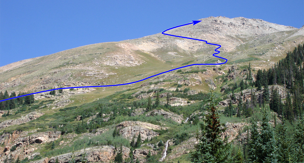
1 provides a view of most of the route. Leave the trailhead and follow the North Halfmoon Lakes Trail through the forest (
2,
3). After 1.25 miles, reach open terrain where you can see Massive's southwest slopes ahead (
4,
5). Exit the forest, weave through some willows, and cross the open area to reach a trail junction
at 11,200' (
6,
7). While the main trail continues west toward North Halfmoon Lakes, turn right onto your trail for Massive.
Hike steeply up through trees and pass through a small boulder field near 11,400' (
8). Continue higher to reach a second, larger boulder field at 11,700' (
9). The trail becomes slightly harder to follow as it weaves through the rocks. At approximately 11,900', the trail angles to the right (northeast) and ascends out of the boulder field. Next, switchback up the steep terrain until you reach 12,000' (
10). At 12,200', you'll arrive at gentler terrain and traverse northeast (
11). As you approach a pointed rock pile
, much of the remaining route becomes visible to your left. Continue all the way to the rock pile at 12,300' (
12).
Next, pass through some willows and continue north over a small hill where the route ahead will become visible once more (
13). Continue along the trail and prepare to ascend more challenging terrain up to your left (
14). Your next objective is to climb north/northwest and gain a ridge that intersects with the summit ridge. If snow covers the slopes, use
13 as a reference to identify the route's general location. Follow the zigzagging trail as it climbs toward the ridge (
15,
16). Above 14,000', the switchbacks begin to tighten, leading to a notch before the trail turns right toward the summit ridge (
17). Continue northeast to reach the "top" of the ridge, near 14,200', where the summit ridge comes into view (
18).
Drop slightly to reach a notch and junction
, where the standard East Slopes trail intersects your route. Take some time here to familiarize yourself with the area, as you’ll want to ensure you don’t miss your turn onto the correct trail when descending. From the junction, stay to the right of the ridge crest and work your way through the rocky terrain (
19). Pass another point (
20) before reaching easier ground on the ridge crest (
21). Pass a false summit, from which the true summit finally comes into view (
22,
23). Drop slightly to a saddle before gaining the summit (
24,
25).
