Photo

Mount Guyot

Northwest Ridge/Slope
Difficulty Class 2 
Ski/Board: Intermediate, D4 / R2 / II  
Risk FactorsExposure: Moderate
Rockfall Potential: Considerable  
Route-Finding: Moderate  
Commitment: Moderate  
 
TrailheadFrench Gulch
Start10,300 feet
Summit13,370 feet
Total Gain3,100 feet
RT Length7.00 miles
AuthorBillMiddlebrook
Last UpdatedMay 2023
Show More
Photo

Trailhead

From Main Street in Breckenridge, turn east on Wellington which is just north of the Main St./Lincoln stop light. Follow Wellington through a residential area with tons of stop signs. Continue on Wellington to dirt and past mines. After approximately 4 miles from Main Street, there's a marked parking area on the right with signs that ask you not to continue up the road. This is the trailhead. There's a gate shortly after the trailhead.

Route

From the "trailhead," continue up the dirt road. Along the way, Guyot can be seen to the southeast - 1 and 2. After approximately 0.5 mile, pass a gate and continue on the road for another 0.7 mile to find a trail that leaves the main road on the left. In winter, this trail may have ski and snowshoe tracks.

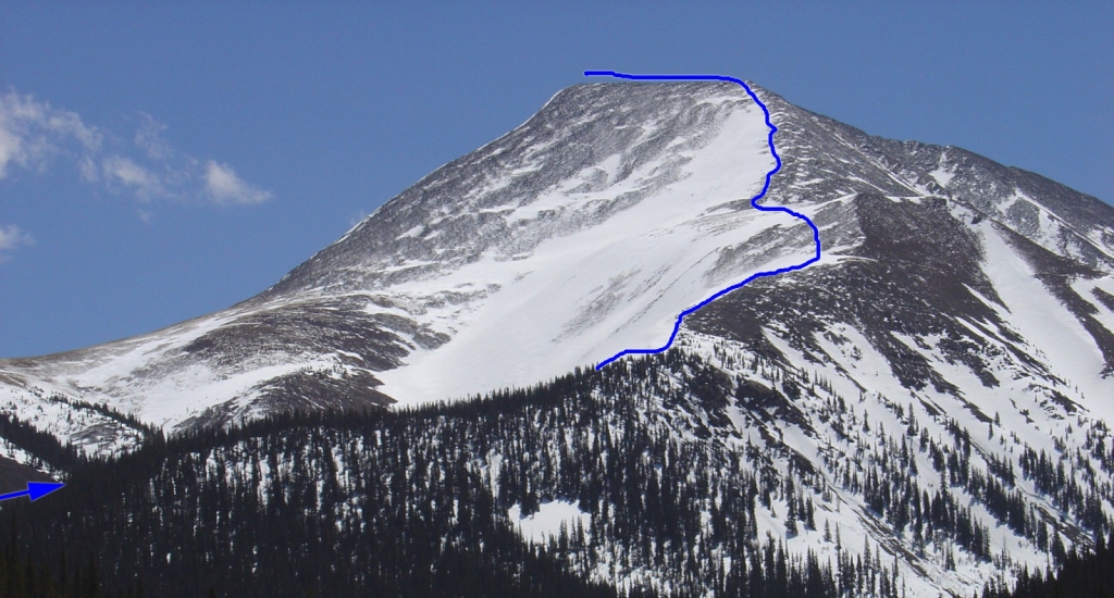
Follow the trail, into Little French Gulch, for over 0.75 mile where it crosses to the right side of the creek. Continue to 11,300' and Mt. Guyot comes back into view - 3 and 4. If you are prepared for a moderate snow climb, the gully in the center of the Northwest Slope can be climbed to reach the upper portions of the Northwest Ridge. The gully does not exceed 30 degrees. In summer, it is best to turn right in this area and gain the Northwest Ridge - 3.

Whether you continue up the center of the slope or gain the ridge, continue to 12,500' on the ridge where the terrain flattens out - 5. 6 looks down from 12,700' and 7 from 13,000'. Grind up through talus to reach the west end of the summit ridge. 8 is another look down the route from the summit ridge.

At the top of the ridge ( 9), turn left and hike 0.1 mile east to the summit - 10.
Skiing?

The Northwest Slope is a fun ski when conditions are right. 4 shows some of the descent choices. The right side of the upper slope ( 11) is just under 30 degrees. 12 was taken near 12,300' on north-facing terrain skier-left of the gully leading down the slope. 13 looks back up at the same area.

Notes

In spring, the road past the trailhead is usually melted out to the trail on the left. If you're skiing, this means there is about a 1.25 mile hike to reach some snow.
#1 #2 #3 #4 #5 #6 #7 #8 #9 #10 #11 #12 #13

The route Google Map can only be accessed by registered 14ers.com users. If you don't have an account, you can register in the forum.

Log In_

Caution: The information contained in this route description may not be accurate and should not be the only resource used in preparation for your climb. Failure to have the necessary experience, physical conditioning, supplies or equipment can result in injury or death. 14ers.com and the author(s) of this route description provide no warranties, either express or implied, that the information provided is accurate or reliable. By using the information provided, you agree to indemnify and hold harmless 14ers.com and the route description author(s) with respect to any claims and demands against them, including any attorney fees and expenses. Please read the 14ers.com Safety and Disclaimer pages for more information.

Please respect private property: 14ers.com supports the rights of private landowners to determine how and by whom their land will be used. In Colorado, it is your responsibility to determine if land is private and to obtain the appropriate permission before entering the property.
Heading to a 14er soon? Don't forget the 14ers.com mobile app.
Google Play   Apple App Store
© 2023 14ers.com®, 14ers Inc.