Log In 
Photo

Culebra Peak

 Northwest Ridge
Difficulty Class 2 
Risk FactorsExposure: Moderate
Rockfall Potential: Moderate  
Route-Finding: Moderate  
Commitment: Moderate  
 
Start11,240 feet
Summit14,053 feet
Total Gain2,700 starting at 4WD trailhead
3,150 starting at Four Way
5,450 starting at ranch HQ building
RT Length5 miles starting at 4WD trailhead
7 miles starting at Four Way
14 miles starting at ranch HQ building
AuthorBillMiddlebrook
Last UpdatedApr 2025
Show More
Photo

Trailhead

From Alamosa or Walsenburg, take U.S. 160 to the town of Fort Garland and...
  • Turn south on Highway 159 and drive just over 15.5 miles to reach the town of San Luis.
  • Near a Conoco gas station, turn left on 4th Street (P.6 Road) and drive 4.0 miles to the town of Chama.
  • Turn left on the L.7 Road.
  • Drive 3.6 miles on L.7, cross a bridge and turn right on the 25.5 Road (dirt).
  • Drive 0.5 mile on 25.5 and turn left on the M.5 Road.
  • Drive 0.9 mile on M.5 to reach the Cielo Vista Ranch at the North Headquarters gate.
  • The gate is normally closed/locked and ranch representatives will meet you for an escort to the ranch headquarters, usually at 6am on the morning of your hike.
  • Once through the north HQ gate, continue 2 miles to the ranch headquarters for check-in.
  • Leave HQ on an easy-4WD road (It is 4.4 miles total to the upper trailhead).
  • At 0.1 mile, stay right.
  • Near 2.5 miles, the road goes through some great meadows (~11,000').
  • Reach "Four Way" at 3.4 miles. Plenty of parking.
  • Continue straight through Four Way to reach the upper trailhead at 4.4 miles.

Due to inaccuracies, do not use Google/Apple Maps directions to get to the Culebra trailhead. Please use the instructions on the trailhead page.

Route

Culebra Peak is privately owned, and all hikes must be booked in advance through the Cielo Vista Ranch website and start at the ranch. Cielo Vista charges a $150 fee, which must be paid upon arrival or through their website. In recent years, hiking has been allowed from January through July, but availability may vary, so it's essential to contact the ranch for the latest details. There are no other legal routes to Culebra's summit and those who try are trespassing.

1 and 2 are distant views of Culebra from the northwest. Once you enter the ranch ( 3), much of Culebra stays hidden until you ascend above 11,000' on the dirt road. From the ranch headquarters, drive approximately 3.4 miles to a junction known as "Four Way" ( 4, 5). Then continue 1 mile east along the road to reach the upper trailhead, located at 11,650' ( 6, 7).

There is no established trail up Culebra, but hikers typically choose between two main ways to begin the hike: 1) Just before descending to the parking area, locate an old, closed road that heads east. Follow this road, and when it ends, traverse along the north side of the slopes before turning south to follow the northwest ridge. 2) Or take a more direct route by crossing the stream just below the parking area and hiking southeast up Culebra's northwest slopes. The first option is marked as a dashed line on the route photos and map, but the second option is more popular and is the one described here.

Begin at the parking area by walking southeast, crossing the stream, and heading toward the slopes above ( 8). As you climb, move away from the stream and follow a gentle ridge along the south side of the creek ( 9). Above tree line, continue southeast toward the top of the slopes ( 10, 11). At approximately 13,350', you'll reach the ridge crest near a large cairn ( 12, 13). From here, much of the remaining route is visible, though the summit itself is still out of sight ( 14).

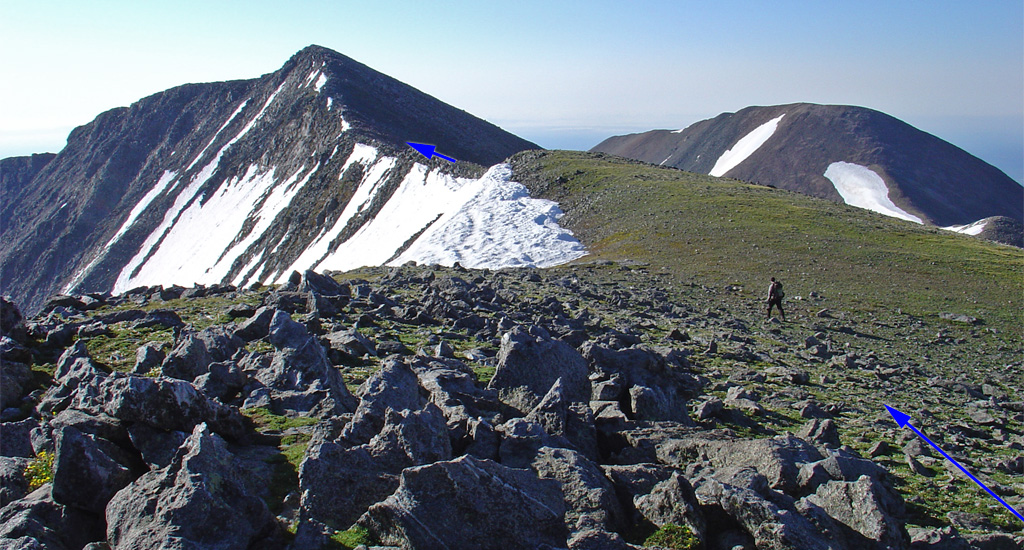
Turn right and head south past the large cairn, navigating through rocks before descending to a 13,200-foot saddle ( 15, 16). Remain on the ridge as it leads east toward a false summit ( 17). While the ridge has a couple of rough sections, route finding is straightforward. Continue climbing over mostly stable rock ( 18) to reach the top of the false summit , at 13,900' ( 19). The true summit is now less than half a mile away ( 20). Descend slightly, pass over a small hump, and make your way up the final pitch ( 21, 22) to reach the summit ( 23, 24).
Notes

None
#1 #2 #3 #4 #5 #6 #7 #8 #9 #10 #11 #12 #13 #14 #15 #16 #17 #18 #19 #20 #21 #22 #23 #24

This page is only available to registered 14ers.com users. If you don't have an account, you can register in the forum.

Log In_

This page is only available to registered 14ers.com users. If you don't have an account, you can register in the forum.

Log In_

This page is only available to registered 14ers.com users. If you don't have an account, you can register in the forum.

Log In_

Caution: The information contained in this route description may not be accurate and should not be the only resource used in preparation for your climb. Failure to have the necessary experience, physical conditioning, supplies or equipment can result in injury or death. 14ers.com and the author(s) of this route description provide no warranties, either express or implied, that the information provided is accurate or reliable. By using the information provided, you agree to indemnify and hold harmless 14ers.com and the route description author(s) with respect to any claims and demands against them, including any attorney fees and expenses. Please read the 14ers.com Safety and Disclaimer pages for more information.

Please respect private property: 14ers.com supports the rights of private landowners to determine how and by whom their land will be used. In Colorado, it is your responsibility to determine if land is private and to obtain the appropriate permission before entering the property.
Heading to a 14er soon? Don't forget the 14ers.com mobile app.
Google Play     Apple App Store