So, you've decided to tackle Pikes via the Barr Trail! While the trail is well-maintained all the way to the summit, it's the length, elevation gain, and heat that make this hike such a challenge. Starting early will not only help you secure parking but also get you higher on the slopes before the sun begins to bake the east slopes (
1).
Start up the trail (
2 and
3), switching back west for 1.5 miles before reaching a corner near the Manitou Incline (
4). Stay left here and continue along the Barr Trail, passing another entrance to the Incline (
5). Near 8,600', roughly 2.75 miles from the trailhead, you'll pass through a rock arch (
6). After switchbacking away from the arch, pass a junction that might be confusing later on your descent—just remember to stick with the Barr Trail. Continue for another 0.2 mile to another junction and, again, stay left along the Barr Trail (
7). From here, walk up a hill and then continue across a flatter section for about 2.25 miles until you reach an overlook at just over 5 miles in (
8). The summit is still far away. Hike another mile and you'll reach Barr Camp at 10,100' and 6 miles in (
9). You're halfway there!
After Barr Camp, pass a junction for the Elk Park trail (
10) before heading west and northwest through the forest. Eventually, you'll reach a junction for the Bottomless Pit trail at 10,850' and nearly 7 miles in (
11). Turn left and continue south (
12). Between 11,300' and 12,100', grind your way up about 20 switchbacks to tree line (
13 and
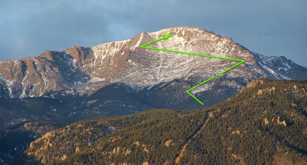
14). Agony. Once you leave the trees, you'll continue up toward the north side of the rocky east slopes (
15). Take on another 10+ switchbacks before reaching the northern edge of the east slopes, at 12,800' and approximately 9.75 miles in (
16 and
17).
You're so close to the summit, but if only the trail were straight. The Barr Trail, however, isn't known for being direct. Traverse south across the slope (
18) until you reach a corner at 13,200', about 10.75 miles in. Here, you can enjoy a great view of Pikes Peak's southern cirque. Be careful as the terrain drops off just a short distance from the trail -
19. Next, turn back to the northwest and traverse less than 0.5 mile across the upper east slope (
20 and
21) until you reach the infamous final stretch: the "16 Golden Stairs" -
22. Don't ask. Grind your way up to 14,000' (
23), passing a plaque (
24) honoring the man who created this beast of a trail. Push through a few more switchbacks until, finally, you reach the summit -
25 and
26.
