Log In 
Photo

Tabeguache Peak

West Ridge
Difficulty Class 2 
Risk FactorsExposure: Moderate
Rockfall Potential: Considerable  
Route-Finding: Considerable  
Commitment: Considerable  
 
Start10,500 feet
Summit14,158 feet
Total Gain4,000 feet
RT Length8 miles
Last UpdatedAug 2023
Show More
Photo
Information
In 2003, the US Forest Service closed Tabeguache's old southwest ridge route starting at Jennings Creek, placing a sign reading "The Jennings Creek Trail is Closed." However, this only applies to that old, closed route. Jennings Creek is still a viable way to climb the West Ridge route on Tabeguache, but ensure you stay on-route both up and down. Avoid the old southwest ridge route and do NOT descend early into McCoy Gulch, as it leads to cliffs.

Trailhead

Drive to the intersection of U.S. 285 and U.S. 50 in Poncha Springs. Go west on U.S. 50 for 6 miles and turn right on County Road (CR) 240. After 3 miles, CR 240 turns to dirt. Continue 0.6 mile to the Angel of Shavano trailhead, campground and picnic area. After the campground, the road turns to 4WD. Continue another 3.8 miles to reach the unmarked trailhead on the right. The total drive from U.S. 50 is approx. 7.6 miles. There's parking for 2 or 3 vehicles but you'll also find some pull-offs along the road, 0.25 mile below the trailhead and 0.4 mile above. Since the trailhead signs have been removed, it's easy to miss; Here are the coordinates: N 38.60050, W -106.27888

Route Description

NOTE: If you hike Tabeguache via this route, you MUST return the same way. DO NOT descend early and enter McCoy Gulch because it ends in cliffs and many hikers have gotten into trouble making that mistake. Don't do it. Not even in a thunderstorm! Study the route, maps and photos and take a map and/or GPS with you to make sure you stay on-route.

This route is different from the old southwest ridge route which was closed by the US Forest Service, back in 2003. Both the Jennings Creek trailhead (unmarked) and west ridge route are on public land so there's nothing wrong with climbing Tabeguache Peak from Jennings Creek but please stay away from the southwest ridge. At 8 miles and approx. 4,000' of elevation gain, the west ridge is a good option for hikers who don't feel comfortable with the effort required to hike Tabeguache Peak via the standard route, over Mt. Shavano.

From 10,500', hike up through dense trees on a decent trail -  1 and  2. Near 11,200', the trees thin out a bit and the trail reaches a flat area near a small tarn. STOP! You'll probably notice that the trail continues east toward the southwest ridge. Don't go there. Once you see the tarn ( 3), turn left , hike past the tarn and continue north along the east side of Jennings Creek -  3 and  4. Without a trail, continue north by staying near the base of the talus on your right -  5 and  6. Near 11,700', stay out of the willows by ascending slightly east away from the creek -  7. Continue along the center of the creek ( 8 and  9) and angle northwest near 12,300' to reach the upper end of the basin -  10. Just ahead is the ridge which connects 13er Carbonate Mountain (left) and Tabegauche Peak -  10. Locate a trail leading up to the ridge and ascend to a small saddle -  11,  12 and  13.

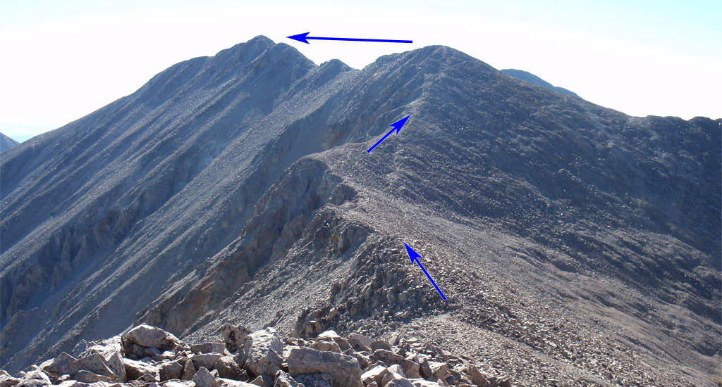
From the 12,600-foot saddle , turn right and follow the ridge east toward Point 13,936', which blocks your view of Tabeguache -  14. Near 13,000', gain a small point ( 15) where you'll get a better view of Point 13,936' -  16. Follow the ridge ( 17 and  18) up to 13,600' to reach some rust-colored rock -  19. Stay left and continue up steeper terrain to reach the top of Point 13,936' -  20 and  21. Some people choose to bypass the top of Point 13,936' but the best option is to go over the top.

Drop from Point 13,936 and continue east along the ridge ( 22) to reach a low point, near 13,800' -  23. Staying on or just right of the ridge crest, ascend a false summit ( 24) to finally see Tabeguache's summit, over 0.2 miles away -  25. Hike over a couple of points along the summit ridge by staying on or right of the ridge crest -  26,  27 and  28. This last section of ridge is the crux of the route and a bit of route-finding may be required to keep the difficulty at Class 2. Taken from the summit,  29 looks back on the upper route. DESCEND VIA THE SAME ROUTE: You must hike back over Point 13,936'. DO NOT take a shortcut down the southwest ridge or descend early into McCoy Gulch.
#1 #2 #3 #4 #5 #6 #7 #8 #9 #10 #11 #12 #13 #14 #15 #16 #17 #18 #19 #20 #21 #22 #23 #24 #25 #26 #27 #28 #29

This page is only available to registered 14ers.com users. If you don't have an account, you can register in the forum.

Log In_

This page is only available to registered 14ers.com users. If you don't have an account, you can register in the forum.

Log In_

This page is only available to registered 14ers.com users. If you don't have an account, you can register in the forum.

Log In_

Caution: The information contained in this route may not be accurate and should not be the only resource used in preparation for your climb. Failure to have the necessary experience, physical conditioning, supplies or equipment can result in injury or death. 14ers.com and the author(s) of this route provide no warranties, either express or implied, that the information provided is accurate or reliable. By using the information provided, you agree to indemnify and hold harmless 14ers.com and the route author(s) with respect to any claims and demands against them, including any attorney fees and expenses. Please read the 14ers.com Safety and Disclaimer pages for more information.

Please respect private property: 14ers.com supports the rights of private landowners to determine how and by whom their land will be used. In Colorado, it is your responsibility to determine if land is private and to obtain the appropriate permission before entering the property.
Heading to a 14er soon? Don't forget the 14ers.com mobile app.
Google Play     Apple App Store