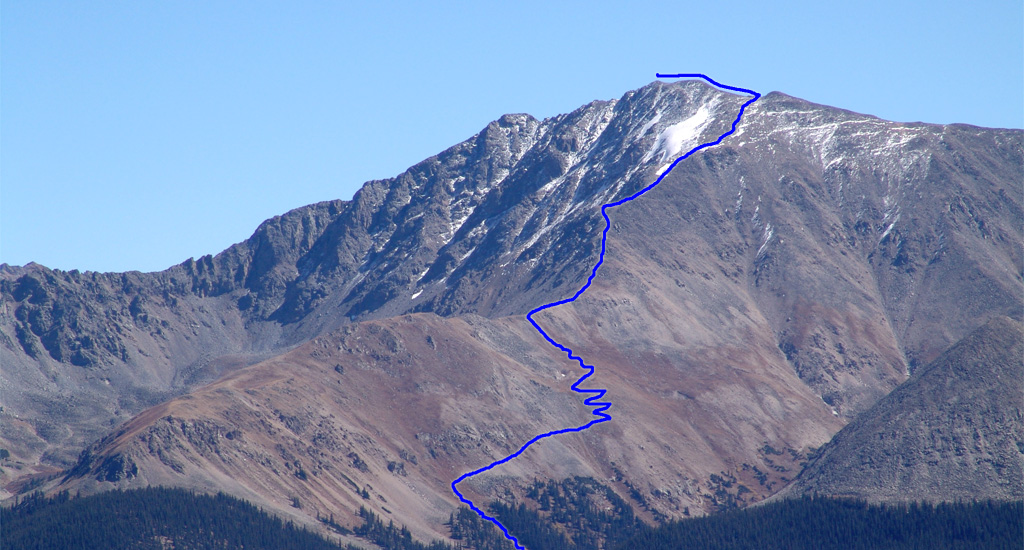
1 shows the route from further up Colorado 82. From the parking area, walk down South Fork Lake Creek Road for 100 yards, cross a vehicle bridge (
2), and continue for 1/4 mile to a trail sign on the left (
3). Walk east into the forest and continue on the La Plata Gulch Trail. Hike through the forest and cross the South Fork of Lake Creek on a sturdy bridge (
4). Walk another 1/3 mile and cross La Plata Gulch Creek on a log bridge (
5). Turn right, continue south along the creek and pass through a small clearing. When you reach 10,400', the trail becomes much steeper as you climb near the east side of the creek (
6). Continue up 500 feet of elevation (
7) before the slope finally eases.
Above 11,000', walk along the gulch until the trail heads left, away from the gulch (
8). Climb back into the trees and traverse to reach a steep, narrow gully
(
9). Using a series of small switchbacks, climb the gully to reach 11,800'. Turn right and traverse south across the hillside (
10). At 12,100', climb another series of switchbacks (
11). Near 12,300', reach a flat area and a square boulder
(
12). Walk through an open area before turning left to ascend a rocky section that leads to northwest ridge (
13). Once on the ridge
(12,750'), you are still 1.25 miles from the summit, and the hiking becomes more challenging (
14). The remaining route weaves through the rocks near the ridge crest.
Hike to the base of a buttress and follow the trail right, to the west side of the ridge (
15). While it can be a bit difficult to follow, the trail swings to the right of the buttress before climbing back to the ridge. This is the most confusing part of the hike, as talus makes route-finding a bit tricky. Follow the trail as it eventually turns left back to the ridge (
16). If you lose the trail and feel you have gone too far along the west side, turn left and regain the ridge crest. Once back on the ridge crest, hike higher to reach a flat spot at 13,500' (
17). The summit is visible, but steep climbing remains. If firm snow is present on the next 300 feet, and you brought microspikes, ascending the snow may make for an easier ascent. Near 13,800', the trail is easier to follow and the difficulty eases slightly (
18). Above 14,000', head south to reach a point near 14,200' (
19). Turn left and follow the faint trail to the summit (
20,
21,
22,
23).
