| Report Type | Full |
| Peak(s) |
Mt. Blue Sky - 14,268 feet Mt. Warren - 13,314 feet Rogers Peak - 13,361 feet 12967 - 12,967 feet Sugarloaf Peak - 12,523 feet Griffith Mountain - 11,581 feet Saxon Mountain - 11,551 feet Alpine Peak - 11,536 feet Ute Benchmark - 11,494 feet |
| Date Posted | 10/04/2025 |
| Modified | 02/11/2026 |
| Date Climbed | 10/02/2025 |
| Author | Alpine_Iris |
| Mt. Blue Sky, the stupid way | ||||||||||||||||||||||||||||||||||||
|---|---|---|---|---|---|---|---|---|---|---|---|---|---|---|---|---|---|---|---|---|---|---|---|---|---|---|---|---|---|---|---|---|---|---|---|---|
|
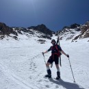
Stats: 28.8 Miles, 10,695 ft of vert, 14 hours 39 minutes, 9 ranked peaks (four 11ers, two 12ers, two 13ers, one 14er) and 7.4 miles of downhill biking
Also visited some unranked points: West Blue Sky, Mt. Spalding, Independence Mountain, Little Sugarloaf Peak, Woodchuck Peak I have sort of been putting off Mt. Blue Sky, not counting two failed attempts I had a few years ago. In 2021, I got off route on the sawtooth, had a panic attack, bailed to abyss lake and hiked all the way around Bierstadt to get back to Guanella Pass. In winter 2022, I was part way up Blue Sky when I realized I wasn't moving fast enough in my snowshoes to summit, and I went to Gray Wolf instead. In the interim, there just hadn't been a route up Blue Sky that I wanted to do. Guanella Pass is a circus, it would be silly to do bsky without its two 13ers, road to the top is lame, blah, blah. But as I whittled away at other peaks in the front range, a striking curve of unclimbed peaks emerged on the map. Four 11ers, two 12ers, two 13ers, and bsky. Could I do them all in one day? Should I do them all in one day? Well I did, but first I had to figure out the logistics. Any pure hiking loop I could contrive was just too many miles for me to do in one day. A car shuttle was a possibility, but I don't know anyone who would want to do this hike with me, and the early start or uncertain end time seemed too inconvenient to burden someone else with if they weren't doing the hike. After the recent success of the bike shuttle on my Grays and Torreys hike, I started thinking about how a bike shuttle could work for these peaks. Echo lake was the obvious end point, and using google street view, I found a pullout on chicago creek road next to cascade creek road for the starting point. I was a bit nervous about biking on the steep curvy road (I don't ride my bike much), but I decided worst case scenario I could walk the 7 miles to my car if it felt that unsafe. After doing Mt. Logan earlier in the week, I knew that it would be totally dry on the 12ers and below, and that it was probably dry enough on the higher stuff. It had been a while since I did a huge day, and a basically perfect forecast sealed the deal. I woke up around 3 am, ate some brownies, and started driving to echo lake. I locked my bike and helmet to a fence at echo lake, and drove back down the road to my starting point. I started hiking up cascade creek road around 5:10 AM. Hiking in the dark always freaks me out, and these birds that make loud flapping noises when they take off kept scaring the shit out of me. Like when the noise starts it's not obvious that it's a bird, it's just a deep vibrating sound. About 2,000 ft of vert into the road, it was light enough for me to turn off my headlamp, and a bit later the sun started to rise. 
Now that I could see my surroundings, I was a bit disappointed that it had been too dark to see colors. There were a lot of aspens, and I definitely passed the best ones in the dark. I kept moving on the forest roads, eventually turning towards my first peak, Ute Benchmark. There was a short off trail section through pleasant forest, and I reached the summit around 7:25 AM. The morning light was beautiful, and I could see the big peaks of the day off in the distance 
Wow, that stuff looked far away. Trying not to think about it too much, I made my way over to Saxon Mountain, mostly on forest service roads. Saxon had basically the same views as Ute, but it also had a ton of really cool bristlecones, some of the biggest ones I've seen. 
I ran into some absolutely awful baby aspen 'schwacking coming off of saxon, and I'm pretty sure it was avoidable too. In the middle of the aspens I found an old mining structure. 

I went over the unranked woodchuck peak (cool boulders) and eventually hit another road that would take me nearly to the summit of Griffith. The summit area was nice and open, which allowed for some nice views. By this point I had done ~4300ft of vert and I was feeling great. 
The section between Griffith and Alpine went pretty quick, and I started getting better and better views of a huge patch of aspens on the hillside behind me. The summit of alpine was rocky enough to fit its name, and had probably the best views of the 11ers on this hike. 


Over unranked independence mountain, aspens and pines gave way to open meadows. I saw a group of 5ish bighorn sheep, but they made a quick exit before I could get a photo. I nearly missed the tiny unranked point little sugarloaf, at least it had some interesting rock/cliffs near it. I usually wouldn't have bothered with the unranked stuff, but I'll probably never be back here, they were all right on my line, and the bit of extra vert was probably necessary to make sure I hit 10k ft. 


After Little Sugarloaf, I began ascending Sugarloaf, which would be the first 12er of the day. I passed treeline, which had some cool krummholz, and made my way up to the pointy summit. 


I took my first long-ish break of the day on sugarloaf. I had packed so much food this time: chocolate chip cookies, brownies, cinnamon roll pop tarts, gummy bears, peanut butter filled pretzels. I think on sugarloaf I opted for a brownie or two. After experiencing the bliss of chocolate at 12,000ft, I started heading to my next peak, 12967, which was promoted to ranked due to lidar data a few years ago. The terrain was very pleasant grass, with embedded rocks in places. completely dry, but as the views of the higher peaks got better, it became clear that I wouldn't be able to avoid snow for much longer. 


From the 12er, I started making my way towards the unranked 13er Mt. Spalding. I contoured around a bump on the ridge, and did the same to gray wolf. I didn't have much of a desire to repeat that one, but if for some reason somebody repeats this outing, you could fix that omission. Below Gray Wolf, aiming for a less snowy way up Spalding, I ran into some really wet areas and totally soaked my trail runners. Once I was past the water and heading up Spalding, I stopped to air out my socks. I had an extra pair, but I decided to save those for after the mandatory snow between Spalding and blue sky. Socks a little drier, I took Spalding's west ridge to its summit, which was mostly snow free. 


To get from Spalding to the west ridge of Blue Sky, I had to trudge through some ankle deep snow. This was also where I saw some of the only people of the day, about 100 meters from me. It looked like they were coming down from blue sky, and I'm not sure if they saw me. 
Eventually I made it to the west ridge, where snow was still present, but relented to the point where I could mostly hop on rocks. 9000ft of vert and 20 miles into my day, I was feeling pretty tired. My legs felt pretty good, but I had to really focus on going slow enough that my heart rate didn't get too high. I enjoyed the talus on blue sky quite a bit, and the views of the sawtooth were amazing. There was only one part that was slightly sketchy due to wetness, and I'm sure it was avoidable. I decided to go to the unranked west blue sky since I had been doing the unranked extras all day. Pretty cool rock up there, and it is not much of a detour. 


Eventually I made it to the actual summit of blue sky. My highest peak of the day, I took some time to soak in the views and eat my last brownie. I must have been pretty out of it, because I forgot to take any pictures up there. I thought it was cool that I could see cathedral spires, one of my favorite peaks. I had just been there a few weeks ago to climb the class 5 peak Bishop Rock. I descended from the summit to the parking lot, and then plunge stepped my way down the snowy NE slopes to the road. I followed the road to summit lake, and then I started making my way up Mt. Warren. I followed the grassy slopes to the right of the ridge, and went straight up when I felt like I was close enough to the summit. 


The sun was getting low in the sky and I noticed my shadow getting longer and longer. I started to accept that I would be doing some hiking in the dark. Rogers was rockier than I expected, but I eventually made it to the summit. The sun was finally setting, and the light was so beautiful up there. 


I was a little nervous about hiking down (and especially biking) in the dark, but it stayed light out for a while longer, and I was on the road for much of it. I didn't need my headlamp until I cut one of the huge switchbacks in the road to head directly to echo lake. I got low enough for the forest to come back, and I found myself moving through deadfall with just my headlamp to guide me. It was eerily quiet, and I tried not to think about how scary it felt. I was back on the road for a few minutes before starting my final descent to echo lake, through more forest. This stuff was more open than the previous bit, and as I got closer to the lake I started to hear campers. I got a little turned around when I finally hit a trail, but I corrected, and I popped out of the forest right into somebody's campsite. They had a projector set up and they were watching some adam sandler movie. who even likes adam sandler movies? After probably scaring the shit out of those people (who deserved it bc they were watching a bad movie), I followed the trail back to my bike, which was exactly how I left it around 15 hours earlier. With some difficulty, I successfully attached my headlamp to my bike helmet (probably should have tried that out before I needed to do it in the dark after a full day of hiking). The ride down went pretty smoothly, it was late enough that there were no cars going the same direction as me, but it was really really cold. I definitely should have put on my gloves and maybe a jacket. The ride seemed like it was going on forever, and I didn't have the foresight to count the switchbacks. I started to worry that I had passed my car, but then it appeared! I was tired and cold but I was so happy to be there. It took me a few tries to lift my bike onto my bike rack, and then I was in the warmth of the car, eating the extra cookies and brownies I had stashed for this occasion. My whole body was vibrating, I think from a combination of the cold, the full day of exertion, and the excitement of finishing this crazy hike. I'm so happy that I was able to do this one, my biggest day of hiking yet by any metric I can think of. Also kind of a send off for this summer season. I didn't do as many peaks as I did last year, but I did do a lot of things that pushed my limits, like this hike, the big grays and torreys hike, and the 3 5th class peaks I did. Maybe if the weather stays nice a little longer I could squeeze in another hike like this, but the shorter days definitely make things harder. I hope you enjoyed reading my trip report! I'm not sure if anyone would ever want to repeat this outing (who even likes 11ers?) but doing it a few weeks earlier would give you better aspens, more daytime, and probably less snow up high. It was a pretty fun way to get 9 ranked peaks! Thumbnails for uploaded photos (click to open slideshow): ")
")
")
")
")
")
")
")
")
")
")
")
")
")
")
")
")
")
")
")
")
")
")
")
")
")
")
")
")
")
")
")
")
")
")
")
")
")
")
")
")
")
")
")
")
")
")
")
")
|
| Comments or Questions | |||||||||
|---|---|---|---|---|---|---|---|---|---|
|
Caution: The information contained in this report may not be accurate and should not be the only resource used in preparation for your climb. Failure to have the necessary experience, physical conditioning, supplies or equipment can result in injury or death. 14ers.com and the author(s) of this report provide no warranties, either express or implied, that the information provided is accurate or reliable. By using the information provided, you agree to indemnify and hold harmless 14ers.com and the report author(s) with respect to any claims and demands against them, including any attorney fees and expenses. Please read the 14ers.com Safety and Disclaimer pages for more information.
Please respect private property: 14ers.com supports the rights of private landowners to determine how and by whom their land will be used. In Colorado, it is your responsibility to determine if land is private and to obtain the appropriate permission before entering the property.