Download Agreement, Release, and Acknowledgement of Risk:
You (the person requesting this file download) fully understand mountain climbing ("Activity") involves risks and dangers of serious bodily injury, including permanent disability, paralysis, and death ("Risks") and you fully accept and assume all such risks and all responsibility for losses, costs, and damages you incur as a result of your participation in this Activity.
You acknowledge that information in the file you have chosen to download may not be accurate and may contain errors. You agree to assume all risks when using this information and agree to release and discharge 14ers.com, 14ers Inc. and the author(s) of such information (collectively, the "Released Parties").
You hereby discharge the Released Parties from all damages, actions, claims and liabilities of any nature, specifically including, but not limited to, damages, actions, claims and liabilities arising from or related to the negligence of the Released Parties. You further agree to indemnify, hold harmless and defend 14ers.com, 14ers Inc. and each of the other Released Parties from and against any loss, damage, liability and expense, including costs and attorney fees, incurred by 14ers.com, 14ers Inc. or any of the other Released Parties as a result of you using information provided on the 14ers.com or 14ers Inc. websites.
You have read this agreement, fully understand its terms and intend it to be a complete and unconditional release of all liability to the greatest extent allowed by law and agree that if any portion of this agreement is held to be invalid the balance, notwithstanding, shall continue in full force and effect.
By clicking "OK" you agree to these terms. If you DO NOT agree, click "Cancel"...
First time attempting an overnight backpacking trip after years of very very very long day hikes exclusively. So after escaping work a bit early on Friday, my buddy and I packed up the car and headed out to the Browns Creek Trailhead where we arrived just around 5:30pm. The trailhead was very accessible 2WD road, for anyone looking to do the non-standard route up Antero.
With our packs on, we began our hike along the Little Browns Creek trail. Note as other Trip Reports have mentioned you will first have to make a right hand turn about 1.3 miles in, and then a sharp left about 0.3 miles later. We ended up settling on a spot about 3.2 miles into the trail and began setting up for the night.
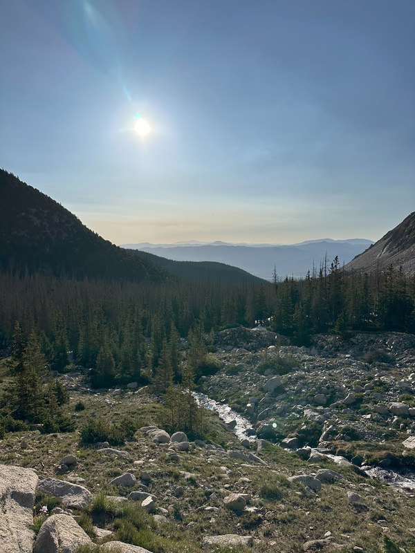
At 5:00am we were up and at em, on our way up the trail. Plenty of nice campsite along the creek all the way up to the tree line. We continued up the trail all the way through the valley until reaching the intersection with the standard route/4WD road. After a quick break admiring Mount White (that's been looming over you the whole time), we began our ascent towards the saddle of Antero. This section still had a few snow patches, all that were easily avoidable or easily walkable (without spikes). This trail is extremely easy to follow the entire time.
Breaking tree line
On top of the saddle you get your first real good glimpse of the summit of Antero. Very straight forward ridge up to the summit, Class 2 action all the way. We tended to stay to the right of the ridge at first to avoid the wind, but it becomes unavoidable eventually. Hardest part for me the whole dang trip was that last 500 ft summit push, with some damn strong wind gusts all the way up. Haven't felt strong of gusts like that in a long time, and it caught me a bit off guard. Forecast was 100% right when they said 40 mph gusts. But after a lot of small choppy steps I was on top of Antero.
Thinking it was going to be a short break at the summit from all the wind, I was amazed and shocked to find the summit not breezy one bit.
Overall an absolute fantastic route and peak. Overlooking the entire Sawatch range was stunning, especially enjoyed the view of Shav and Tab. Easily one of my favorite views from the range. This was peak 25/58 for myself and my buddy. Only two left in the range as well. Great way to kick off the 2025 season, and a more overnighters to come!
Summit of Antero
GPS clocked us at 16.2 Miles and 5,443 ft elev. gain round trip.
Thumbnails for uploaded photos (click to open slideshow):
Comments or Questions
Caution: The information contained in this report may not be accurate and should not be the only resource used in preparation for your climb. Failure to have the necessary experience, physical conditioning, supplies or equipment can result in injury or death. 14ers.com and the author(s) of this report provide no warranties, either express or implied, that the information provided is accurate or reliable. By using the information provided, you agree to indemnify and hold harmless 14ers.com and the report author(s) with respect to any claims and demands against them, including any attorney fees and expenses. Please read the 14ers.com Safety and Disclaimer pages for more information.
Please respect private property: 14ers.com supports the rights of private landowners to determine how and by whom their land will be used. In Colorado, it is your responsibility to determine if land is private and to obtain the appropriate permission before entering the property.
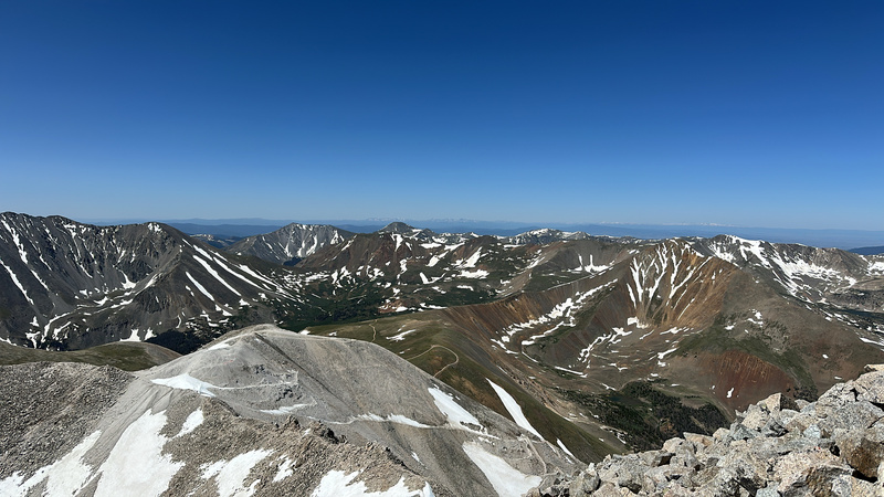
 Summit of Antero")
 Just above treeline of Little Browns Creek")

