It was reading Dobson's report of Finnegan that got me considering a different approach to this peak, instead of the "standard slog" from NY Lake to the west. https://www.14ers.com/php14ers/tripreport.php?trip=21455
Noting that the Lake Creek trail continues for many miles to the south after the dead dog cutoff, I wondered if a loop would be possible. (I don't know why, but I instinctively prefer a loop to an out and back.) Setting forth on a perfect September day, I found one of my more enjoyable outings in the Sawatch. This day ended up being 21.5 miles/7643'.

Aspens were in splendor at the end of September in the Holy Cross wilderness, and this trail is well-established.

The trail continued strong well after the junction for the dead dog. The initial miles after that junction went very easily, owing to the gentle and overall downhill grade. At one spot, I found an overgrown junkyard: a bunch of mining artifacts succumbing to the undergrowth.
a
The terrain opened up into a broad meadow, and beaver activity in spots created small ponds. The trail at times through here was more difficult to follow, and I also had to cross two ponds on logs. I paused to watch the brook trout dallying in the shadows on one of these crossings.
A pointy peak loomed ahead and I checked my gps. It's an unnamed feature east of Lake Thomas. With the drop on the west side, it has to be ranked. Only briefly did I consider adding an 11er to the day's work: I had gotten an already crazy late start owing to some last minute plan changes that moved Finnegan to this day on which I had originally planned to be mountain biking, so there was no time for such indulgences. This peak became a sign post: I knew I would need to leave the trail before I drew level with it.

The decision of when to bushwhack was made for me. I followed a spur trail heading west, as strong as the main trail and then, I found myself here:

With no longer any trail and not wanting to retrace my steps, I checked the gps and my location seemed to be in good spot for gaining the bench that would lead south to Lake Thomas, so up the hill I went. It began steeply, but soon relented.

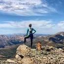
Really not too bad.

Now there's a valley ahead, and then a steep ridge, and beyond that, Finnegan. No thanks.

So I headed more WNW than my prior SW line. I found a few stretches of trail, and then the ruins of a cabin.

Moving north from the cabin, I then looped up tranquil grassy slopes to resume a westerly, and eventually southwesterly direction. I found this mountainside beautiful, owing to the rich golds and reds of the plants that blanketed it.


I found a tiny stream and stopped because the day felt closer to summer than fall, so a little splash would feel rejuvenating.

After splashing my face and soaking my hat, I looked back the way I had come, at the expanse of autumn splendor.

After such a long approach, I was getting closer than I realized. Before I knew it, a pond stretched out before me, and Finnegan didn't look as far away. I"ll call this Tomasito. Just a small stretch of ground separates this lakelet from the larger body of Lake Thomas.

And then I got positively excited and nerdy, like a 12 year old boy in the woods again. Resting above Lake Thomas, stretching up toward Finnegan's north ridge were some of the most delectable slabs I had seen. I spent a few minutes by the shore of Lake Thomas, trying to see if I could get a good photo, but the angle of the sun relative to the lake was not helping. So I pocketed the phone and bounded to the slabs.


As I walked up the huge slab, admiring the play of the low-angled sunbeams on the features all around and gazing back at the jewel of Lake Thomas, the way upward also captivated me. The path forward looked like a titanic staircase descending from Finnegan's north ridge. I dubbed this the East Face Staircase Route.

This middle section before the staircase consisted of tundra and rock. When I got up close to the rock features like the one below, I found a range of class 3 to class 5 options. Also it seemed that many place where I scrambled, I may have found a class 2 bypass if I looked around. . As I was seeking speed at this point but not looking to be bored, I stuck to class 3.

A quartz outcrop I found interesting:

Another look back down to Lake Thomas:

Soon I reached the base of the staircase, which began as simple class 2+ but offered more challenging obstacles higher up.

It's a pretty wide face, so a lot of wandering from side to side could be done to minimize the difficulty, but, near the top, it becomes steeper and more pinched. While nearly all class 3, I found isolated but mandatory class 4 in this area.


I reached the top of the N ridge that leads to Finnegan at a point just south of the prominent gendarme that separates it from unranked point 13,092. It had taken just under 7 hours to get here. 
I made my up the ridge and then deviated from it on a prominent ledge leading out on the north face. Several cairns had been put at intervals here, but I spent no time looking for them. The face is wide and fractured with ledges and blocks, so numerous options exist to reach the top. After twenty minutes, I was at the top, finally.
The views from Finnegan's summit are stupendous. I was limited in what pictures I could take, as any west-angled vantage put me right into the setting sun. The Holy Cross Wilderness does not disappoint, and I had so many peaks and ridges splayed out before me to the south. Below is a view looking southeast.

As I began retracing my steps down, the path ahead appeared deceptively direct, as many drops hid terrain from view.

One more view of Lake Thomas:

With the sunlight dwindling fast, I wanted to to be off the ridge before needling to rely on the headlamp. I found the hardest move of the day, some pretty stout class 4 stuff, as I made may around the gendarme that stands just north of the east face staircase.

A look back at the class 4 obstacle and Finnegan looming tall behind it. I didn't surmount the block in the foreground, but negotiated the wall to its left (east) side, getting back to the ridge crest where the stick was planted by a prior hiker.

As I continued along the ridge, the valleys fell into shadow.

The US topo shows the area north of Point 13092 as steeper and more narrow than it actually is. From this point, gentle slopes dropped northeast to a wide bench overhanging the Middle Creek valley. I took this way down, instead of keeping to the ridge, which provided a quicker way to the low point before Point 12,078.

Gaining this point involved the last bit of scrambling for the day, but posed no notable complexity. On the north side of this point, I paused to enjoy the sunset. It was 6:47 pm, 1 hour and 52 minutes since I had taken my first step down from the top of Finnegan, so the traverse had taken me about 30-40 minutes longer than I had anticipated.

Now I just had to locate the Dead Dog trail. I walked steadily down the slope, which I had expected to be a great deal more tundra than talus, but nothing laborious. Veering a bit westward from the ridge line as I consulted my gps, I picked it up as twilight began deepening. The Dead Dog trail provides an excellent path but it also contains a good deal of roots and rocks, which my toes found frequently in the dark. I've always used my headlamp at lower intensity to preserve battery life and this trip revealed to me how much my night vision has declined over the last several years. I returned to the trailhead at 11 hours and 3 minutes from when I had left it mid-morning.
While many of the Sawatch peaks are just large hills, this day was one of the most rewarding that I have spent there. In my memory bank, I group it with the two different ridge traverses south of it, Gold Dust-Pika, the unnamed peaks south of those, the Apostles traverse, the peaks north of Independence Pass, and the Wheeler traverse.
I hope you enjoyed reading this at least 1/100 as much I enjoyed making this trek.
 sunset on the descent")
 Unranked 12,078 on descent")
 the shadow camel")
 view back to Finnegan after obstacle")
 class 4 obstacle on N ridge")
 view of the N ridge descent off Finnegan")
 gazing SE from the top")
 Lake Thomas from base of summit push")
 finally - Finnegan")
")
")
 nearing the top of the N ridge")
 Lake Thomas from higher up")
 quartz outcrop")
 middle section of rock tundra")
 Finnegan and the")
 slab me, am I dreaming?")
 slab back at ya- a look to Tomasito")
 Lake Thomas from first slab")
 shadows and slabs")
 pond just before Lake Thomas")
 view back at the Red Meadow")
 refreshing streamlet")
 Finnegan above the fall foliage")
")
")
")
")
")
")
 the meadows and the false Finnegan")
 mining debris just off the trail")
 well-defined Lake Fork trail")
 aspens along the trail")