| Report Type | Full |
| Peak(s) |
Mt. Shavano - 14,230 feet Mt. Antero - 14,271 feet Mt. Bross - 14,178 feet Tabeguache Peak - 14,158 feet Mt. Princeton - 14,200 feet Uncompahgre Peak - 14,318 feet |
| Date Posted | 09/09/2024 |
| Date Climbed | 07/05/2019 |
| Author | HikesInGeologicTime |
| Tying Loose Ends on Mountains That Do Not Require Ropes |
|---|
|
Notes: There should probably be a subcategory of "Full" trip reports: Novella, Novel, Fantasy Series...at a mere 12,000+ words chasing 13k', I think this qualifies as a mere Novella, but DYBM for not challenging us writers to push our own limits! I once again used dark gray text to indicate copy-pasted TRs from days of yore, and I kept in some of the "Editor's notes" in which I added a description/caption for a photo for the benefit of those listening to the audio version of this write-up on my podcast. Since I direct people here if they want the written version, I feel it's best to have that written version be as true to the spoken edition as possible. One could argue that my entire history with fourteeners was grounded in revenge. After all, one could posit that a failure on Pikes kicked off the whole journey, if they wanted to claim that my fourteener journey started in 2004 and lasted 19 years instead of starting in 2005 with my successful summit of Mt. Freaking Bierstadt and lasted only 18 as I would prefer to claim. One could further point out that my finisher fourteener of Crestone Peak was absolutely a revenge summit. I’d attempted that mountain a little over a year before my success story and had simply not been physically or mentally up to the challenge on that first try. Granted, one could pile on to state that I wasn’t physically or mentally up to the challenge on the second try, either, but by that point in The Journey, I was way past Over It in mind if not yet in body and therefore didn’t care how good or bad I felt inside and out, I was fully prepared to crawl both up and down the crowning Crestone on four bloody stumps if necessary just to be able to say I was capital-D Done. 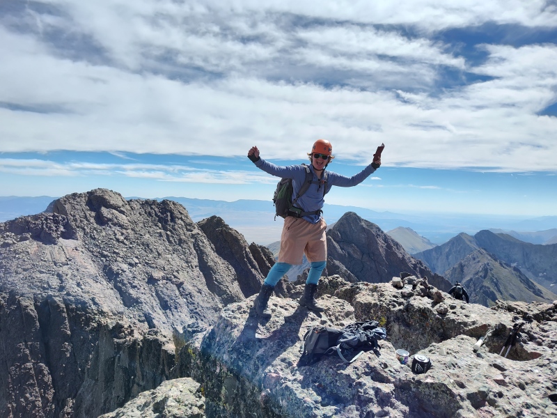
That is, of course, another story for another day. Today’s story is centered on the embarrassing-to-me-anyway number of fourteeners that took me one or more attempts before I finally got at least a hand or boot on their highest prominences, the “embarrassing” aspect of it entering the equation because so many of those fourteeners, namely the ones that will be the (anti?)heroes of this particular episode, are not exactly known for their technical difficulty. Many of them, in fact, are Sawatches. The Sawatch range, as I gushed about in my last outing, is unpopular among many vocal fourteener fans due to its highest points’ relative ease of access. I have more affection than what seems to be your average fourteener-er for that reason alone, an affection perhaps borne out of having been able to summit six of them on the first go and earn my vengeance on another five in less than a year - sometimes less than a month - following my initial attempt. That did, however, leave four of the range at its southern end that I had yet to summit by the time 2017 was in its downward spiral toward its cold, dark, snowy exit. As mentioned during the downward spiral - uh, I mean, wrapping up - of my Sawatch tribute, I probably should’ve left the year on the triumphant if slightly undignified note of summiting Mt. Columbia, a fourteener whose standard route had only a trail-in-progress that was not actually open to the public at that time and which therefore would inspire me to pithy poetry in a comment on 14ers.com’s forum responding to a thread proposing slogans reminding hikers to stay on route: “When on a hike/ Don’t trail-cut/ Unless you like/ Rocks up your butt.” That, however, was not my first comment on the forums, although it would have been rather fitting, in its own way, if it had been. Instead, I first felt compelled to bare my soul to the forums after nearly a year of mostly silence on the account I had created, HikesInGeologicTime, which I had established in October 2016, though I had of course already posted a trip report on Mt. Yale in August of 2017. But as summer 2017 fell into autumn, my friendship with Jimmy, my high-school still-bestie-but-just-barely, was quickly nearing its dissolution. Perhaps a little bit of panic over my impending isolation from the one person in my life who was still into fourteeners (my dad having retired from them over a decade previously) prompted me to make tentative overtures in the resource already at hand full of those who would share my own interests but hopefully have fewer criminal pursuits as secondary hobbies. Therefore, before posting my second trip report on Columbia as well as my Shakespearean masterpiece (in my defense, at least the rhythm and meter were consistent throughout, though I suppose that qualification depends on whether one considers “trail” to have one syllable or two), I decided it was time to quit holding back from the more back-and-forth, dialogue-resemblant nature of the forums and post to a thread entitled, “Shav/Tab in the snow,” where the original poster had wondered about potential safety concerns on the Sawatch’s southernmost pair of fourteeners, Mt. Shavano and Tabeguache Peak, after they’d received an early-season coating of frostiness. I had nothing to say about the safety aspect, having not done or even attempted either mountain before and having limited experience overall with mountains where there is just enough snow to downgrade the quality of a hike but not enough yet to have a good time skiing. The first week of October, however, was just a touch too early for even the Colorado ski resorts that pride themselves on their super-long seasons to open - not that I had Arapahoe Basin, Loveland, or Wolf Creek on that year’s ski pass anyway - and apparently whatever experience I did have with hiking at that time of year plus reassurances from other commenters to the thread prompted me to add this on October 3rd: “If the forecast holds for this weekend, I may try these Saturday or Sunday (or Friday, if the National Weather Service downgrades its wind gust predictions). I've had my eye on them all summer, and since I do have some winter experience + no shame about wearing full ski gear (turned out to be a great idea when I climbed Harvard in those godawful wind gusts two weeks ago!), I want to see how far I can get. Anyone is welcome to join me, though as my name suggests, I am [Ed. note: this I typed in lowercase] s-l-o-w-!” While hindsight does make me chuckle at my gumption in thinking an admittedly super gusty Harvard in September in what was still calendar summer, albeit barely, plus a couple decades and some of resort skiing, where one can duck inside for an overpriced hot chocolate if the winter conditions that allow for the activity become a little too wintry, added up to “winter experience,” I nevertheless did have a couple takers. 
While I have long since lost that private message due to the .com’s stored-message limits, Eric, a.k.a. yaktoleft13, and his wife Amanda, both of whom I had met and subjected to several profane thoughts on Mt. Elbert when we were all on that physically if not metaphorically mighty mountain in July 2016 for their first time on it and my second, were also working on the southern Sawatch and, Eric told me through PM, would be happy to have company. We arranged to meet at the trailhead at dark o’clock in the morning, and while I seem to remember having a quick personal gloat at having my pack loaded and ready to go a few minutes before our scheduled departure time, my fleeting sense of meaningless victory quickly faded in the sound of my own heavy breathing as I tried desperately to keep their spry, surefooted, athletic forms somewhere within range of my headlamp. I was a mess when I didn’t so much catch up to them as stumbled to where they’d been waiting for me long enough to have a leisurely snack and drink break in the first hints of morning light. Even without the challenges of keeping up with partners who had clearly acclimated to fourteeners in the two years since we’d last sorta hiked together and were now far stronger than I would ever be, just resigning myself to going at my own pace a ways back had demanded more of me than anything with an obvious trail and this many oxygen-exhaling trees still surrounding me should have. I regretfully told them to go ahead without me. I suspect I must’ve attempted to hike at least a little further on my own, based on what I wrote in the trip report that is shortly to follow, but unlike my new buddies whose friendship was to take place strictly off-trail based on our vastly differing paces, it was clear that I would have to come back for Shavano’s summit, although without extending an open invitation on the forums before the next outing. But just like Arnold Schwarzenegger’s titular character in Terminator 2, I too was bahck, and less than two weeks later, not to mention bolstered by somewhat-more-meaningful personal victory on Columbia in the interim, as I wrote in my increasingly cleverly-titled-or-so-I-thought report “Shavano, Hold the Tabeguache” on October 20th, two days after my sorta successful climb: “‘Pfffft,’ I thought to myself, maybe even getting a little spit on my laptop screen as my inner thoughts became outer thoughts, ‘Shavano and Tabeguache will be just like Bel/Ox. Similar mileage, similar elevation gain, and unlike when I climbed their northern neighbors in June, I'll be conditioned from seven other fourteeners this season when I tackle S&T!’ Those of us who did the reading in high school and college lit classes know what happens to those who suffer from serious cases of hubris. This one, at least, didn't end with death, accidental incest, or the utter ruin of formerly proud kingdoms - in fact, the worst I suffered was a sore IT band on my left knee (at least it wasn't my driving leg, though I am left-side dominant, so it's been a literal pain everywhere outside of my car) and a small taste of humble pie. In short, I only had enough wind in my sails for Shavano. I don't know whether it was the cold (which had gotten to my toes on the summit, and as a Type I diabetic, I have to pay attention to that for fear of amputations), the wind (which wasn't the worst I've put up with - both Harvard and Columbia were worse), or the purely agonizing, seemingly Sisyphean nature of the slog uphill. I'd attempted Shav/Tab a week and a half before. I chalked my inability to get above ~11,600’ that time to allergy-induced asthma* (Editor’s note, or rather, footnote from the original: “*Yes, I did indeed hit the genetic lottery. X(“ ) from staying in a condo that hadn't been vacuumed since the last time a dog who excels at shedding spent a weekend there. I turned around, pounded allergy meds and took ritual puffs of my inhaler the rest of the day, went to bed early, and successfully climbed Columbia the next day. 
This time, I stayed in my own pet hair-free home the night before, brought the inhaler just the same, and was chagrined to find that I was just as out of breath as, and doing little better timewise than, on my recent attempt. With the paradoxical liberation of realizing that hiking this one was going to suck harder than the tornado that carried Dorothy off to Oz no matter what, I decided to press on. I knew already that I was unlikely to make the Tabeguache traverse, starved for oxygen as I already was, and thus I vowed to at least bag the one so that I would never have to ascend this loathsome lungbuster of a sub-treeline incline ever again. The snow was minimal and mostly avoidable, and I didn't see much on the traverse when I did reach the summit. Still, I took one look at the rocky road ahead and confirmed that continuing on to Tab was a solid, ‘Aw hellllllll no.’ 
Even though I regret that decision ever so slightly now that I've looked at the West Slopes ‘trail’ description (ffs, I thought I was done with the Choose Your Own Adventure: Sawatches Edition after I bagged Columbia earlier this month!), I know I made the right call. I'm more stiff after this one than I was after any of the others I've done this season, and even though I set a personal season record for time spent hiking (helped by the fact that the cold and wind were just dismal enough that I only spent five minutes on the summit), this one felt like it delivered the harshest ass (and knee)-kicking I've received in a while. It also didn't help the overall mood that I was promised sunny skies, though in the National Weather Service's defense, I suspect most of those ‘clouds’ were actually smoke from the controlled burns in the area. Still, it definitely felt like winter was winning out. 
I am nonetheless quite pleased that I got Shavano checked off, if only because trails where that much of the elevation gain takes place below treeline can go do inappropriate things to themselves. P.S. Anyone wanna do Tab in the next couple weeks?! Even with that also-open invitation, I did not get any takers in the last days of October or first few of November. Apparently I found some distractions from the sting of still needing the more diminutive of the pair, however; I recall that I did participate in the .com’s annual Winter Welcomer event on Quandary Peak the first weekend in November, a hike intended to introduce those new to trekking the coldest, darkest, snowiest, and therefore most questionable months of the year to the questionability of doing so, and anyway, I had two other Sawatches still on my as-yet unchecked list. I’m not entirely sure what put Antero, the next fourteener north of Shav and Tab, on my radar, as whatever prompted it is not in my .com commenting history, nor, thanks to the aforementioned inbox storage limits on the.com, do I still possess the PMs I know I must have exchanged with my partner for my first outing in a series of trials and errors on a mountain that probably has to be in the Bottom Ten, potentially Five, if there were such a thing as “fan”-based lists of Least Favorite Fourteeners. Presumably my would-be partner had posted something publicly to the forums with an invitation of his own to which I also presumably decided to RSVP; given my already-existent non-fan status when it comes to alternate routes, it seems highly unlikely that I’d been the one to initiate the specifics of this plan. I do know that this first attempt did prompt my first-ever Conditions Report on the site, which I can say with absolute certainty that I put a rosier spin on than I actually felt while it was taking place. Of my October 25th hike partway up the East Ridge from Raspberry Gulch - which, to reiterate, is not the standard route or even close to it - I wrote: “Attempted the Raspberry Gulch route with a cool guy I met on here yesterday. I only got to 12,100 feet before deciding that I was too slow to summit and make it back to the trailhead before having to flail around in a dark forest, but conditions were prime for faster hikers to make an ascent this way: bluebird day, minimal snow through treeline and the first talus hill, and little to no snow visible on the rest of the route. As for the trailhead, well, it's fairly obvious that it's the road less taken. The dirt road along CR 270, 272, and 274 is easy 2WD dirt, but after turning onto 273, the driving gets a little trickier. The road is one-car-width (sometimes barely that...don't try this unless you're okay with having branches leave love scrapes in your paint) with only sporadic places to pull off, and my Subaru Outback's AWD and ground clearance came in very handy a few times. Would not recommend in any vehicle not similarly equipped.” I know that this was an evasively chipper take, love scrapes (a.k.a. Colorado pinstripes) and all, because I do remember having been cranky at yet again having a partner who was clearly way more of an athlete than I was, a partner I would once again wave ahead of me as I huffed and puffed while doubled over on some high point likely just above the last straggling trees along the ridgeline, then periodically screaming wordlessly at that forest when I retreated on my own for having the gall to still be there, so full of trees (who cares about their oxygen production on the descent, after all), and so unwilling to simply cough up the old road that marked a short remaining jaunt back to where my poor long-suffering Subaru Outback with its brand-new all-natural exterior redesign waited. 
Clearly this failure got under my skin, enough so that, although there is no remaining record of it in my comment history, conditions reports, or trip reports, I nevertheless do recall agreeing to meet with yet another fit, 20-something “cool guy” I was apparently desperate to audition as a potential replacement Jimmy at some point in November for an attempt at Antero’s standard route, which follows an increasingly rough 4WD road up to 13,800’, then follows a trail - or at least something resembling one - along the mountain’s south ridge for the last 400’ to its summit. Not that I could confirm the entirety of that route description on the occasion of the November outing, however. Once again, I’d paired off with a partner who was younger, faster, and stronger than I was, and once again, I got just barely above treeline before having to bid him to go on without me as I wheezed into my knees for a few minutes before once again retreating in disgrace all the way back down to the 2WD trailhead just off the smooth dirt road where we’d parked at dark o’clock AM the night/morning/both/neither before. So perhaps it is no surprise that Antero became my normal-ish-people’s-climbing-season opener for 2018. I detailed none of my previous history with the mountain when I wrote a trip report clickbaitily entitled “Mt. Antero: Another Instance In Which HIGT Loses the Trail” on May 18th, 2018 of my May 16th climb: “Considering I have the Colfax Half-Marathon coming up on Sunday, tackling a fourteener - especially one with a trail as lengthy as Antero's in its current state - was perhaps a questionable decision. But I couldn't resist; the weather was perfect (seriously, there wasn't even any wind on the summit ridge!), I'd read that conditions looked more like late June than mid-May, and I figured that after 16 miles and 4000 feet of elevation gain over a rocky road with some steep scrambling at the end, 13.1 miles on flat pavement that doesn't fluctuate much around that mere mile above sea level wouldn't be so bad. Or possibly I simply hate myself. A case could be made for both. I started at 5:10 a.m., summited at 11:26, and returned to the trailhead at 4:48. I felt pretty good about my sub-12-hours time, considering this was my first of the season...and of course I had a few misadventures along the way. My major source of consternation was the ridgeline between the end of the Jeep road and the final summit pitch. The trail along it is far more obvious from above than below it; my advice to anyone attempting it in its current state would be to choose the highest option when faced with two or more potential paths, lest you wind up traversing the top of the snow still clinging to the slope. I mean, if you *want* to know what sinking hip-deep into spring snow and then feeling like you're scrambling up the pitch with slightly melted Slurpee remnants in your boots is like, by all means, go the same way I did! Otherwise, stay high and stay dry. 
That wasn't my only opportunity to give my lower extremities a bath, however, as I also ran into trouble at the Baldwin Creek crossing. There is one rock that is smaller and slightly more rounded than its neighbors. It is coated in ice before the sun has a chance to hit it and slick with water after that. Suffice to say that it's fortunate the temps were as warm as they were, because I needed to spend some time wringing out my socks after it foiled me coming and going. Overall, however, this was a great introductory fourteener for Summer 2018, and now is the time if you're feeling masochistic...er, adventurous enough for the full sixteen miles; I only saw one other person the whole day, and there's still a little too much snow that is too deep and goes on for too long for all but the most intrepid of four-wheelers with some serious enhancements to take on after the creek crossing, so it's currently a hiker's haven. Because I like to make occasional lists of things, here are items that I am glad I did not have weighing down my pack, as they would have been unnecessary: snowshoes, goggles, helmet. Some things I did have but did not need: microspikes, an extra shirt. Some things I wished I'd had: spare socks, gaiters, a jumbo pack of Wet Wipes instead of the mere travel pack I had. Without getting into overly TMI territory, let's just say that going off a medication that wreaks havoc on the ol' GI tract right before climbing above 10,000 feet can sometimes have some...explosive results. X( “ I suppose I probably need not expand on the explosivity referenced in that last line, although my final time to date wistfully wishing that there actually was a Poop Fairy did lead me to conclude that I 1) needed to invest in either a trowel or more wag bags, having long since filled the ones I’d received with my Mt. Whitney permit back in 2016 though had kept pristine until long after returning to my home state, and 2) that no matter how soporific drives from Denver to increasingly far-flung trailheads are in the dark of night, under no circumstances was I drinking coffee on them ever again. Maybe there truly was some GI-upsetting medicine or new lack thereof involved as opposed to me making shameless and/or shameful excuses, I don’t remember. I do remember the concentrated caffeine and how quiet my lower abdomen was after I cut it out of my pre-hike routine. In what will hopefully be my final words on the subject for, like, the rest of time, then, I will say that sticking to the second point did help me not need to contemplate the first for another couple years, not until I needed to start overnight backpacking trips in order to have a realistic-for-me chance at playing Fourteener Pokemon: Gotta Climb ‘Em All! I did also leave out the moments following my second dip in the precisely 32.000…01-degree waters of Baldwin Creek during which, figuring I’d already gotten a decent soaking, I might as well go for broke with a full-on skinny dip of my lower half to clean off the grit I’d gotten in, well, everything while sloshing out of the creek the second time. The dip had only lasted a second or two; did I mention that water was just barely warm enough to be liquid?! But that was just as well, because the temperatures motivated me to get my pants back on and even mostly zipped up by the time THE other hiker I saw on the mountain that day came into view just above me and gave me a cheery greeting before beginning her own careful tread across the creek. In spite of all the aggravation required before, on, arguably in, perhaps a few other prepositions as well about Antero, I ultimately would’ve found the mount to be a suitable entry for my Sawatch love poetry. Of course I realize that my at-last success story was due in no small part to having had it largely to myself on that particular day, but at the time, I dismissed other fourteener chasers’ revulsion of it. Success on kindly Antero was a perfectly delectable set-up, I sincerely hoped, for what I fully intended to be my Summer of Sweeping up the Sawatch. Before that, however, I had another sweep-up of another mount that might very well top - or, rather, bottom - the List of Fan Non-Favorite Fourteeners in Colorado. Mount Bross was a particularly humiliating nemesis peak, as in addition to just being a trivial climb - its summit is only 2250’ higher than its regular summer trailhead, and the .com route description states the roundtrip mileage for it alone, minus the rest of the Democrat, Cameron, Lincoln combo, at a piddling 3.25 miles, none of which exceeds a walkable Class 2 - I had somehow failed to make that trifling summit on THREE separate prior occasions. The first, of course, had been all the way back in 2013, when Jimmy and I were still friends and his crimes were still unknown to law enforcement and the world at large. He, his dog, and I had managed to climb the other three peaks in the loop commonly called the DeCaLiBron - a nickname I disparage because there is no N at the end of Bross; the only way that appellation works as stated is if you reclimb Cameron, which does have an ending of N, on your way back to the Kite Lake trailhead - but ran out of time to continue on to Bross, the peak most commonly climbed last in the group, before the stormclouds mounting behind us urged us to reclimb the easier Cameron with no Bross before it so we could make quicker work of the descent. I had then revisited that miserable rock heap whose rocks just so happen to be piled above 14k’ in September 2015, exactly one week after my successful (a.k.a. Search and Rescue-free) second summit of Longs Peak, optimistically hoping to start a trend, for the weeks I had snuck back home from my brief residence in Southern California, of climbing a new-to-me fourteener each week the forecast beckoned me to do so. As I had finally completed Longs to my satisfaction on the 11th, I set out for Kite Lake on the 18th under an unsullied blue sky with a cardboard sign bearing Mt. Bross’ name and elevation as well as the hashtag I vaguely hoped would start a trend on Instagram, #fourteenerfriday. Most likely that trend wouldn’t have taken off anyway, is my sour-grapes consolation for the fact that, despite Bross having absolutely nothing on Longs in terms of its length, maximum steepness, or technical difficulty, I simply did not have it in me that day. I got perhaps halfway up the gully marking its West Slope - the most efficient way to summit Bross without bothering about the other three - and, despite the continued lack of any indicators that the heavens were once again inclined to rebuke me for my contempt, straight-up decided I’d had enough of that route’s steep looseness for one day. 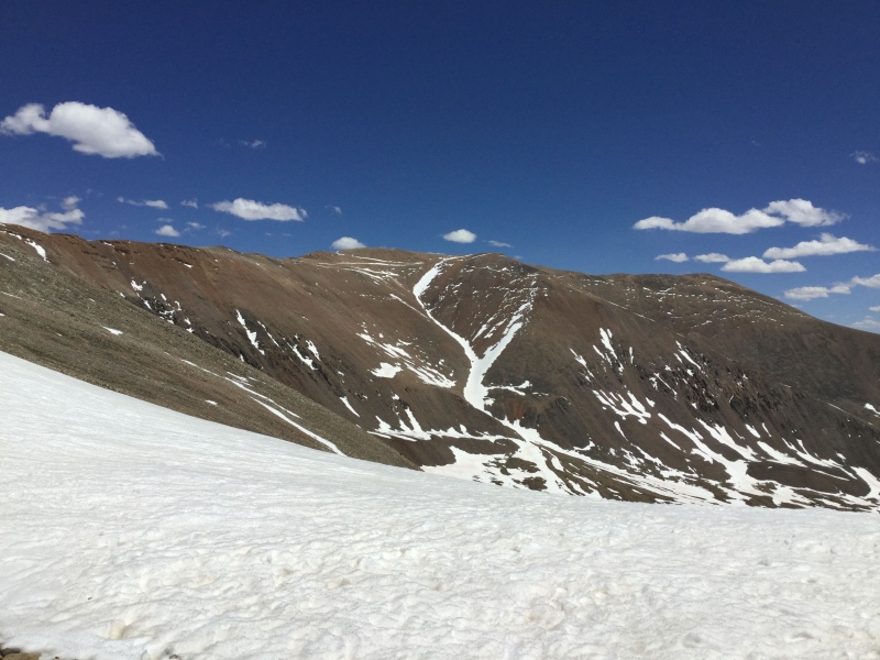
I would put it out of my mind for another two years. Then, on the last day of November 2017, apparently clinging stubbornly to the optimism of the seven Sawatches I had summited in sunnier times that year and not the self-inflicted miseries of the aborted attempts starting in late October, I decided that I needed to try to squeeze just one last southern Sawatch in before the year’s end, and as December 1st apparently marked the start of a months-long road closure due to animal migration, I would have to make my attempt of Princeton on the 30th. But while the sign I could swear I saw near the bottom of the 4WD road as well as any other traces of the stated purpose for the closure have apparently vanished down the collective memory hole - seriously, I’ve been able to find no record of that sign that I am fairly certain I wasn’t hallucinating on that particular mountain! - I quickly discovered that there was no need for any sort of wordy warning compelling drivers to turn around: soon after I started up the more treacherous road climbing to a parking area that would shave off some of the mileage and vert of tedious road-walking, I rounded the first sharp switchback…and immediately had to reverse back down due to the solid sheet of ice coating the span of the roadbed. I believe I did make a second attempt to gun my poor Subie up, over, perhaps yet more prepositions, and most importantly past it; just reaching the 2WD trailhead for Princeton takes a good 2.5 uncaffeinated hours from Denver that I was naturally inclined to justify somehow. After reversing a second time, however, I paused to give some serious reflection to my life choices. While I quickly decided those were a matter simultaneously far too serious and farcical to be contemplating at that time of the morning with no coffee in my system, I did come to the regretful realization that even if I did manage to surpass this first obstacle, who knew how many other ones there would be higher up on the road…and whether I’d be able to easily reverse my way out of them. I further regretfully concluded that, rather like with Bross two years before, I simply did not have the gusto needed to go all the way from where I could park that day, though unlike with Bross, Princeton from the trailhead I could access at that time would at least have been a respectably lengthy hike at 13.5 miles. Deciding that I was not worthy of any such respect that day did, however, give me the idea for the consolation prize I could consider. The Kite Lake trailhead would also be open on the last day of November, and while I was just as unenthusiastic at the idea of dragging myself all the way up that horrid gully the trail went through on its west slopes in practically-winter as I had been in still-barely-summer, I did have an alternate option for reaching the yet-unreached summit: Mount Cameron! I’d had success going up and over that mountain going to and coming from Mount Lincoln the time I had been able to claim summits in that loop, after all, and Bross’ summit was hardly that much farther away from the unranked bump serving as a hub for the three True and Proper(™) summits surrounding it than the presidential peak is. Alas that this latest attempt was no bluebird still-summer September day but instead a sunny-yet-otherwise-practically-wintry day in almost-December. The hoof up to the saddle between Democrat and Cameron was unmemorably unremarkable, but the winds amped up their own evident gusto the higher I struggled on the ridgeline leading to Cameron’s laughably unremarkable summit nevertheless rendered somewhat memorable by the 57 false summits leading up to it. 
I got about halfway up that bumpy ridgeline - so, approximately False Summit # 29 or so - before realizing that for the second time on an attempt of Bross specifically and the second time on an attempt of a fourteener for November 30th, 2017 that I simply did not have the right stuff to go all the way there and back again. I once again turned back toward Kite Lake with my virtual tail tucked between my too-sore-to-be-anything-but-real legs, swearing that vengeance would be mine for Bross…as well as, of course, for Princeton. But clearly the bumpiest lump of rocks in the Rocky Mountains was the higher priority. In spring 2018, a week after Antero and a few days after I had well and truly earned the participation trophy that was my medal for the Colfax Half Marathon, I returned to Kite Lake a fourth time, or at least, close enough to Kite Lake to call it that. As I wrote in the first trailhead conditions update that I would post to the .com on May 25th, the same day I had occasion to observe conditions, “The snow that previously stopped everyone two switchbacks from the TH had been plowed on Friday afternoon. Still some snow on the road, and it will doubtlessly be icy in the early morning, but as of yesterday, the parking lot was accessible to cars.” I myself knew the exact number of switchbacks left to be plowed Friday morning because I’d arrived early enough that they were not plowed yet when I parked. Still, two switchbacks was hardly a make-or-break addition to the day, short as the distance between them was, and since parking at the proper trailhead necessitates paying an $8 fee to the nearby town of Alma, I was perfectly content to add less than half a mile onto an already not-big deal of a day for the advantage of having that much extra in the post-hike lunch and/or coffee fund. I do sort of wish I had made an entry under the peak conditions updates or written a trip report about my travails with Bross to boast about the fourth time being the charm for attempts on it, but I know exactly why I didn’t…and no, it was not simply the humiliation of being foiled by Bross, of all the so-called peaks, that many times. It’s also that attaining Bross’ true high point is unquestionably illegal. The trailhead kiosk at Kite Lake avoids mentioning Bross at all in naming the Democrat, Cameron, and Lincoln loop and explicitly warns hikers to stay strictly to the trail that bypasses the fourth fourteener’s summit, swinging just below it and dropping down into the godawful gully that had given me such grief on my second attempt. And for all the talk I’ve seen on the .com forums stating that there are no signs posted by any of the Bross summit’s multiplicity of owners telling hikers to keep off, I did remember walking up to, and then past, a sign stating something to the effect of “Keep Out - No Trespassing” and/or “Stay on Trail” when I myself worked my way past Cameron on May 25th, 2018, continued on the official trail…and then broke off the designated route to follow a clearly-less-official but nevertheless visibly used path extending upward from that designated route and onto the officially-closed-to-the-public-but-containing-a-summit-shelter-nevertheless rockscape that is the highest terrain of my final itch-under-the-skin-inducing Mosquito fourteener. I did take summit pictures, though I did not post them. This wasn’t so much out of fear of prosecution by that multiplicity of landowners still holding mining claims to slivers of Bross’ summit whose lack of organized agreement on matters of access as well as concern over liability issues has kept the summit strictly private property on paper; I was more concerned about backlash over my flagrant disregard for private property rights on the .com, and not undeserved backlash, I must admit. After all, private property, public access, and the overlap or sometimes lack thereof between the two are rather fraught issues in Colorado, and fears of lawsuits from injured hikers seeking to recover damages that perhaps their insurance companies won’t pay for without a fight have at times led the landowners who control access to several of the Centennial State’s loftiest prominences to err on the side of caution. While the Colorado Fourteeners Initiative foremost among others have made and continue to make excellent strides in obtaining legal access to many of these summits, Bross has been designated as off-limits since 2007 and looks to remain that way for years to come. But while even the Colorado Mountain Club has conceded that some access is better than the risk of no access and thus allows its fourteener completionists to claim a summit for the legally inaccessible peak once they hit the high point on the legally established and recognized trail, my own set of compulsions would bid me to become a proponent of the philosophy of Do as I Say, Not as I Do when it comes to adherence with CFI principles as well as those of state and federal law. My only public reference, therefore, to having been somewhere vaguely within the vicinity of Bross’ true summit - and lacking a warrant for my phone and the laptop to which I transferred the pictures, who else would be able to tell whether or not that meant ON said summit? - was on the Instagram post I made showing and describing some of the sizable snow crossings I’d made after having returned back up and over Cameron, thus, I suppose, justifying calling that day’s outing the CaBron. 

I would later adopt a more-defiant stance of Come and Prosecute Me, Bro when it came to providing proof that I’d made it all the way to the very pinnacle of Rocky Mountaineering that is Bross’ true high point and simply hoping that, should I be called (and arrested) on it, the prosecutor and/or judge would also be into fourteeners and just as compulsive in the quest for True and Proper Summits(™) as I. 
At the time of my first (and no indeed, not last) ascent, though, I simply allowed myself to bask in the vagueposted victory that I could stop grappling with the ways, means, legalities, ethics, and moralities of this non-quandary-in-name peak because what was done was done…and Bross was capital-D Done at last. Whether it was right or not, whether there was some grander cosmic scheme that for some reason decided to make me and my also non-conundrum-in-name attempts at Bross the focus of its own attempts to teach humanity a lesson about disobeying the laws of the land and that was why it had taken me so many tries to see success…no matter. It was finally time for me to get back to matters that all on and off the forum could agree had more stature, or at least, one of them does: Mount Princeton and Tabeguache Peak. Even the more diminutive of the dastardly duo that remained of my Sawatch fourteeners - also the lesser half of the pairing I’d had to leave behind the previous October - would have to wait, however. A screenplay I’d written right around the time I was settling scores with Columbia, creating new ones with Shavano and Antero, and sending my onetime friend from high school a regretful “don’t contact me, I’ll contact you if I ever feel up to it” had taken off in the indie/horror film festival circuit, and the first few weeks of June saw me traveling to the East Coast to accept awards, rub elbows with fellow aspiring as well as some degree of succeeding filmmakers, and use the downtime between schmoozefests to visit with beloved people and places from my days living near the Atlantic Ocean throughout college and grad school. But as nostalgic as I became for the past and as optimistic as I became for a future that might require me to spend significant time outside my home state yet again, well, suffice to say that you can take the hiker out of the mountains, but you can’t take the mountains out of the hiker. After my fellow film festival attendees and I had downed our closing night shots at my final festival for that part of the summer and stumbled back to our hotel rooms to sleep it off before dispersing the next morning, it was time to carpe diem on a fine forecast for Shav’s next-door neighbor, Tabeguache Peak. Despite having only indulged in alcohol, albeit quantities unmatched since I had graduated my last hallowed institutes of higher learning, I was apparently feeling a little Hunter S. Thompson nevertheless when I posted a write-up I entitled “Fear and Loathing on Tabeguache Peak” one day after climbing said mountain with a partner from at least one prior pace-match testing hike. I’d hit the “Save” button to post the report on June 24th, having hiked the peak June 23rd, itself after having returned home only a day or two before, to judge by the report’s contents: “I already knew Tabeguache was going to be...interesting from the day I returned from its next-door neighbor Shavano's summit last October. Having vowed that I was never going to set foot on that granitic hell-beast ever again, I began researching Tab's back-door route from the Jennings Creek TH as soon as I got back to Denver. What I saw made me rue the case of literal-leading-to-metaphorical cold feet that I'd developed on Shav. A rutted-out road? Bushwhacking? A section of four-points-of-contact that looked a little rougher than the mere Class 2 that had been promised? Nevertheless, when I started exchanging messages with Robert, a fellow participant of the amazingly-to-my-eyes popular "Slow Hikers Unite!" thread, and he expressed interest in doing Tabeguache, hold the Shavano, I perked up. I'd most likely have sucked it up and gone via the standard double-whammy route if I'd had to tackle Tab solo, but with someone around to call for help in case I got into a not-atypical amount of trouble, this option suddenly seemed feasible. Feasible or not, I could've picked better personal conditions under which to tackle this monster. I'd spent the previous three weeks in the Eastern Time Zone, most of them at sea level, though I did put in multiple days on a bike trail whose high point was a whopping 827 feet. But biking uses different muscles from hiking, and I had an abundance of oxygen the whole time I was pedaling. I'd only returned to Denver two days before taking on Tab. I nevertheless don't think I can entirely fault my precipitous re-entry to high-altitude hiking for the...interesting times my hiking partner and I had. We knew that Point 13,900 was a false summit. We did not know until we reached the top of it that the, uh, point after it was a false summit as well. We also did not know that the final approach to the real summit contained some scrambling that would later make me compare it to Longs Peak in such a way that I would call the Class 3 fourteener a relative cakewalk, because at least most of the portions of the latter on which you have to cling to a rock face for dear life are on *solid* rock, and even the Trough's gorge of potential rockslide material is packed down well enough that careful foot (and hand) placement can avoid undue danger. Such could not be said for the often-literal crawling that Tab's highest "screw you" to weary travelers necessitated. Part of the issue with that last pitch was that my penchant for losing trails is apparently infectious; the path we had been following petered out where it overlooked an especially ugly gash of a gully. We did manage to pick our way around a precarious series of rocks I would deem at least a Difficult Class 2, though he would later admit that the sight of it had stopped him cold at first, an assertion with which I immediately agreed. I'd also have to say that the ‘real’ route, which we took on the way down, was not, on the whole, that much less perilous. The fun wasn't over even after we got back to the safer territory of the false summit and beyond. The NWS' prediction of gusts up to 35 mph turned out to be a major underestimate, as we discovered while picking our way down Pt. 13,900's sloppy scree slopes; one particularly vicious gust pushed me over while I was attempting to navigate from one unforgiving rock to the next, and I came thisclose to navigating the lower of the two with my face. Apparently I looked like I was in sufficient danger that Robert came running back up that godawful slope (he wasn't that far below me, but allow me to emphasize just how steep and rocky that pitch was to highlight what an effort this must've entailed) to help me back on my feet! The rest of the return trip following that was just...long. Both of us expressed surprise at how much steep downhill we had left after we finally finished Pt. 13,900's scree slopes - we both thought we recalled that the uphill portion between there and the saddle was filled with grassy, gentle rollers of ups and downs, not more fodder for the later griping about my knees and feet that would comprise 90% of later conversations. Still, after one last battle with a steep track of loose dirt and gravel off the saddle, the rest of the route lacked technical difficulty, though both of us were stunned at how long it took us to walk down the road from the TH to our parking space, selected partially because the road was, indeed, so rutted-out that we figured it would take about as long to drive as to walk the full length of it, and also because, in a fit of brilliance, Yours Truly had last fueled up in Nebraska and didn't want to risk being That Person. You know, the one who gets stuck in the middle of a single-lane road after the car runs out of fumes and then never lives down the 14ers.com infamy. But it wasn't all bad, of course. I have my second-to-last Sawatch fourteener checked off the list, the reward for the bushwhacking section of the trail was a bevy of columbines in full bloom, I'm never doing this one again. But I am glad I did it once.” Whether I remain glad I did it once is an ongoing matter of internal debate. I had enjoyed the company that day; he wasn’t Jimmy, thankfully, but as Robert and I had discovered on a May hike of “South Elbert,” a 14k’ point lacking enough prominence from its saddle with THE Elbert to be considered a proper peak in its own right, we were well-matched in pace as well as sense of humor. We last hiked together to THE Elbert in March of 2022, though he turned back early with another member of our group, and I would happily hike with him and any other member of the Calendar Winter Elbert Party of two years ago again, perhaps in no small part because I was occasionally creating some icy dust of my own for my partners to chase. But outside of having found this particular partner to be a fine distraction from the torture my mind had apparently decided to inflict on my body by willing it back to Colorado in such a hurry to take advantage of the ripe opportunity to sneak up on Tab from the backside that not only had I not been able to remember how long it was between my return home and the hike, once on that hike, my body had been eager to retaliate against my mind with copious aches, pains, and other gripes, I clearly did - and still do - not have too many compliments to offer the route itself. After all, that road-walk from where I’d decided to park at such an elevation that I believed I’d be able to coast back to Poncha Springs on gravity alone if necessary had been a long-feeling and dry as well as dusty one, the lack of a proper trail above where the Forest Service has blocked off the old alternate route is unfortunately steep and loose, I was most decidedly not a fan of the surprise sorta scrambling near the summit, and I still remember the impression that everything somehow seemed even worse on the way down than it had been on the way up, probably not helped by a time or several of finding myself echoing last year’s thoughts of Columbia while I’d been descending it: “I’d say this mountain can kiss my rear end, but it already has!” The road-walk then demoralized me even further on the way down when it reminded me, as I shared with my partner, of a story I’d read in high school about a man who nods off while driving an otherwise empty road and wakes up to find that no matter how fast or far he drives, his surroundings never change, because he is in Hell. To this day, then, one that I am 99% certain takes place in a different time and location from where I am surely still not walking down the Jennings Creek access road, as much as I am still somewhat relieved that one can ascend Tab without necessitating a repeat visit of demoralizing Shav if one does fail to summit both on the same trip, I strongly urge wide-eyed innocents new to either to make sure they pick a day that affords them the opportunity to complete the out-and-back traverse to tag both, as the rear assault on Tab alone is, in my opinion, a rather large and sometimes literal pain in the rear. Safe to say, then, that while my later experiences with even more challenging fourteeners would lead me to look back on the Sawatch with the same sort of nostalgia I apparently held for those college nights of taste-testing one too many alcoholic concoctions and finding myself doubled over the dorm room sink because the extra three feet necessary to make it to a toilet were approximately two and a half too many, as 2018 rolled to its halfway point, I was ready to tick my last checkmark for that range. Robert and I did have plans for only a few days after our deep bonding of the kind only the intense shared trauma of boot camp or Tabeguache from Jennings Creek can provide to revisit Princeton, the last bit of unresolved business I had left in the Sawatches as well as leftover from when I had not had the full 13.5 miles nor even the lesser-in-all-the-ways Mount Freaking Bross in me on the last day of that last November. I believe that maybe I did have the full 13.5 miles in me whichever day it was in late June that Robert and I attempted it from the 2WD trailhead out of concerns over the 4WD road’s steepness, rockiness, and narrowness if passing other vehicles - far more of a concern in early summer than almost-winter - became necessary; a comment I posted in response to someone using my (eventual) trip report as a sounding board of sorts for their own Princeton plans had me insist that I would be “crying” if I had to engage in a vehicular dance-off. I could hardly fault Robert when he realized somewhere around 13k’ that he did not find himself to have that many foot-powered miles to his name on that particular day, though; the distance is long and feels even longer, in my opinion, when one is walking a dry, dusty, rutted-out, rocky road instead of a comparatively smoother and unsubjected-to-tires trail, especially when one is hoping for a ride from a hardier soul driving the upper road that simply doesn’t materialize at 5 a.m. on a weekday. But the next few days were also looking good, forecast-wise, and I was determined to get this done, even if I’d needed to crawl something more like the Barr Trail’s 25 mile distance on four bloody stumps to make it happen. Fortunately, as detailed in my July 2nd trip report, “Last Dance with the Sawatch Fourteeners,” which I wrote after merely hiking the last one on July 1st, I made it clear that I did not have to crawl that far or at all, nor even did I have to hike the full length of road after once again deciding to park in the 2WD lot. As detailed in the report, I made clear that I nevertheless had enough “fun” as it was: “It has taken me six years to climb all the fourteeners in the Sawatch Range. This is significantly better than the ten years it took me to complete the Front Range, but not as good as the five the Mosquitoes required and certainly nowhere near the single day that the Tenmiles demanded. Still, as of yesterday, I can safely say I've seen the summit of all sixteen Sawatches, and if ‘fourteeners’ only started with an S, I'd have a wonderfully alliterative sentence to make out of that to boot! As a send-off to the subrange with the three highest peaks in the state, Princeton was...not necessarily the one I would recommend for a victory lap. It may be a mere Class 2, but it wears its scree the way the King of Pop wore sequins. And even without the smoke from the nearby South Park fire obscuring much of the view to the east, Princeton's vistas somehow didn't seem anywhere near as impressive as those of its Collegiate Peaks neighbors. In a couple ways, however, Princeton was a fitting send-off for my experiences in this range. I got to play my apparent favorite Sawatch game of ‘Where the hell did the trail go?!’ on a fairly consistent basis once I got to the final summit pitch. Also much like last week's endeavor and just about all the others before it, that final pitch turned out not to be so final after all, something I should've realized when two of the guys who passed me reached its apex, stared ahead of them, then continued on, their shoulders slumped in defeat. Unlike last week's endeavor, however, the real summit proved to be almost literally only a hop, skip, and jump away, and shortly after 9, I was standing atop my last personally-unconquered 14,000+ foot Sawatch summit. Had it not been for its placement in my personal line-up, I would've called this peak unremarkable; really, the only out-of-the-ordinary occurrence to take place was my exceptional fortune in flagging rides from and to the lower trailhead both ways, and on the way down, right as the truck (whose occupants had stayed in the chalet up the road from the start of the real trail) came past the trailhead! I would soon discover that both of the cars I'd ridden in were part of the same larger group, most of them living in Buena Vista, and I gave them my contact info so that I could buy them drinks and/or dinner next time they're up in Denver; my knees and oversensitivity to heat made me grateful to have been spared the time and mileage the road trek would've necessitated.
But I am, of course, happy to have done it, and happier still that I got it done before the badly-needed monsoons come in. While the state is hopefully getting rehydrated, I can start assembling my camping gear, as I have officially run out of fourteeners that are doable in a day trip from Denver.” Chalk up to fourteener fatigue, English major math, or the long-lasting aftereffects of too much weekend binge-drinking when I’d been of an age to be as collegiate as Princeton - then reminding myself that higher learning can take place at any age, to judge by those film festivals! - that I’d miscalculated the number of Sawatch fourteeners; there are actually only fifteen that are named and ranked and therefore considered to be important enough to be on THE List, though I am certain that I am by far not the only list-chaser to have been under the weary impression that even without factoring in the unranked and unnamed bumps over 14k’ that some masochists enjoy tacking on as well, the tally feels higher. Chalk up to the veracity of the statement that “everyone’s a critic” that, when I cross-posted this write-up to Reddit’s fourteener-centric sub, I got some sass about comparing Princeton’s preponderance of loose rock to the late Michael Jackson’s sometimes sparkly costumes. Chalk up to shyness, maybe, or perhaps some sort of clairvoyance alerting them to the fact that they would forever be associated with someone likening a fourteener to an outlandish costuming choice should they take me up on my offer that I never did get a call about the food and beverages I still feel I owe the hardier souls who did spare my legs and lungs some agony on that popular pre-Fourth of July Sunday of being capital-D Done with the Sawatch fourteeners. Offer’s still good, guys and gals, and I promise I’ll compare Princeton to festering garbage on a hot summer’s day instead! But at last I had finished out the Rocky Mountain subrange with the highest number of fourteeners in it, whatever that number was, and could move onto bigger…or, hmmm, at least I’d been accurate in stating that the Sawatch contains the three highest mountains in the state, so maybe better…well, except that suffice to say there is a reason I would develop a retroactive fondness for the Sawatch’s simplicity. So perhaps I should just leave it at “move on.” Although I will say that the initial peaks to which I first moved on were a few of the finest I encountered in the state, comprising at least three of my genuine Top Ten, Am a Legit Fan, Would Repeat List and certainly all included in the Top Twenty. That, of course, is why I will be skipping over them for now and returning to them as the setup to my next and final episode for Of Mice and Mountaineers’ first season, because as I had learned with the screenplay that continued earning me indie/horror/both film festival accolades into the first half of 2019, every horror story needs a sweetly innocent setup to underscore the eventual grimness and gore! Bad puns involving fourteener-free Rocky Mountain subranges aside, then, let me keep to the theme of going on late-season fourteener attempts in which my eyes would turn out to be bigger than my lung capacity or leg muscles and do the Time Warp again, as the song title goes, but without Tim Curry’s own legs finely filling out his fishnets, seeing as how I already skipped ahead from July 2018 in that last paragraph to spring 2019 and now have to metaphorically scrabble back to October 2018 for the time being. It is yet again anybody’s guess as to who reached out to whom; my forum commenting history has nothing expressing or responding to someone else’s interest in Uncompahgre Peak, a solidly Class 2 hike in the San Juans of the sixth-highest fourteener in the state, located outside Lake City, the nearest population center of sorts to the mountain and in fact the only incorporated town in Hinsdale County…and, I thought as I drove down Highway 149 in the encroaching darkness to meet my latest twentysomething “cool guy” partner at the north end of town, a fantastic potential location for a new horror flick. In fact, as someone who has subsequently made a few horror flicks of their own, I posit that if anybody besides Stephen King himself decided to improve in their own personal view upon Stanley Kubrick’s vision of The Shining, Lake City would make an ideal setting; like the Overlook Hotel in both the book and both the famous as well as made-for-TV versions of the film, much of the town is a summer-only sort of setting, with almost all its businesses packing up shop and their owners and staff fleeing to less remote locales the last week of September, not to return until the snow has more or less started to melt by Memorial Day. Much of the town was, therefore, eerily dark when my partner and I rolled into our proposed meeting spot sometime after sunset. Perhaps it was the fact that the only other evident signs of life besides the two of us had been some deer or elk that we’d passed on the road that prompted me to grumble, as soon as we did meet for the first time in the otherwise abandoned parking lot of the lodge on the northern edge of the, uh, city, that I would be perfectly fine with eating elk jerky. The number of so-called elk jams I’d sat through in and outside Rocky Mountain National Park over the years, I added to my already concerned-looking partner, had me thinking that such a delicacy would be the closest acceptable substitute I was likely to find for the real source of the traffic jams caused by gawking humans, as I doubted I’d be able to find tourist jerky for sale at even the most far-flung gas stations in the state. 
Perhaps it was because there was little to none further that I remember nothing else of our conversation or, for that matter, how exactly we’d arranged to get as far up the Nellie Creek Road, the nervewracking 4WD dirt monstrosity that only the most brazen drivers of Jeeps, 4Runners, Tacomas, and other vehicles with honest-to-goodness 4WD settings as opposed to my Outback’s mere All-Wheel Drive, as we eventually did. Had we left my poor Subie in the lodge’s parking lot and carpooled in my partner’s rented Forester, also not exactly 4WD but a rental for which he’d apparently opted into the premium insurance? Or did we each drive the combination of pavement and smooth, graded, 2WD dirt to the base of the infamous-in-the-fourteenering-world Nellie Creek, where I definitely piled in and tried to be unobtrusive about clutching what I’ve heard called the dry-cleaning or the Jesus handle, depending on one’s religious preferences or lack thereof, while the driver “Woo-HOOO!”ed his way up, over, and across obstacles I would never, ever have inflicted on my own vehicle? Either way, as grateful as I was for his willingness to shave some time and tediously dry and dusty roadwalking off our hike the next day, I couldn’t help but be relieved when he decided some obstacle - a dried-out stream crossing, perhaps, or maybe a slick slab spanning the width of the road just uphill of a sharp switchback - was probably more than even his platinum-level insurance policy could withstand, and so we backed into a pull-off or something resembling one and stopped for the night. I believe I stretched out in the front seat and he in the back for a few hours of restless sleep before our sunrise or perhaps earlier start the next morning. I can say for sure that I should not have been particularly surprised at the eventual ending: with 900 vertical feet left to the summit and after taking a do-as-I-say-not-as-I-do-sorry-CFI “shortcut” to avoid a slick scrabble of early-season snow covering the trail, I had become too drained to continue through the talus we’d found ourselves slipping up and bid him to carry onward and upward while I channeled my future CFI Peak Steward as well as past, present, and future slacker hiker by angling back to the foot-friendlier trail, snowfield be damned. I can no longer remember whether he was successful or whether he too came up just short of victory before realizing that going all the way would invariably mean a dark o’clock descent, and as I do recall him telling me a story on our ascent of how he’d been stalked by a mountain lion on a solo hike, I could certainly understand his reluctance to risk more of the same. In any event, we made it down to his rented car safely, perhaps without needing to pull out our headlamps in tandem and definitely with no further Too-Close Encounters of the Wildlife Kind, then parted ways when he dropped me off back at wherever my car was parked, never to meet again, though despite his youthful exuberance contrasting so heartily with my apparent lack thereof on that day, I hope he, too, is thriving in life and has had the chance to fly back out to the Centennial State and visit more mountains with partners who can keep up with him better. At least I’d learned just enough from the end of 2017 to realize that resistance to the call of the sunny-but-cold-forecasted fourteeners was less futile than surging toward another one’s summit would have been. Unlike with Antero and the rest of my loose ends in the Mosquito and Sawatch Ranges in 2017-18, then, I would deign to skip any more wannabe new summits in late October and November 2018 and wait until early 2019 to make Tim Curry shake a fishnetted leg forward in time. By “early” 2019, however, I actually mean just past the halfway marker. 2019 had started off as an average snow year, but one could argue that things exploded in March, or else why would they have called it a bomb cyclone? The skiing was fantastic when and where it could be done, which was limited for a time as the hefty amounts of new snow even in a region accustomed to and banking on heaps of the frozen fluff meant avalanches galore and resulting highway and even whole ski resort closures where those avalanches ripped new paths and sometimes damaged infrastructure. While conditions had more or less settled by the time late spring rolled around, snow still covered the high country in abundance…and the San Juans had been, shall we say, extra blessed by the snow gods’ beneficence, so I had a while to occupy myself with unusually late-season skiing instead of early-season hiking. 
As I consider myself more of a skier than a hiker, my only genuine gripe about the situation was that Arapahoe Basin, the local-to-me ski area continuously boasting the longest season in the state, if not the country, had some rather unsurprisingly hellacious lift lines for its second-in-a-decade Fourth of July ski day. But I got my two runs in without having to take my skis off for rock-avoidance purposes, ordered my commemorative t-shirt, and was on my way south to the San Juans once the two lifts still running closed for the season with promises to fire up again in three months or so. 
I no longer remember whether the three of us who would be hiking Uncompahgre the next day had agreed in advance that none of us wanted to test the limits of our own insurance policies on Nellie Creek Road, a.k.a. the most challenging portion of the hike that would nevertheless be even more challenging still to drive, but even if anyone had been feeling frisky enough to attempt it, the road was, to go by later conditions reports, apparently visibly closed to vehicle traffic when we arrived, not that I would remember that myself. I do remember for sure that poor Almir, who had driven himself and our third group member Phil from the urban part of the Front Range many hours northeast to the de facto 2WD trailhead, had left his hiking boots at home. He was wearing sneakers, though, and while he realized it was highly suboptimal and warned us that it was likely to slow him down considerably, indicated that he would prefer not to have driven so far without at least putting in a solid effort. It was indeed a nice leisurely day, but I rather enjoyed it. I did feel for Almir, as those sneakers did not look particularly waterproof and the snow crossings were significantly wider, mushier, and more numerous than they had been when I’d last been near the peak in October. 
Nevertheless, all three of us summited. We all got to enjoy some low-angle and late-in-the-day and therefore about-as-safe-as-one-can-get glissading down some of those snowfields on our descent, and Almir, who’d understandably been bringing up the rear on our road walk, managed to score a ride with an apparent Nellie Creek Road pro who had driven all the way to the evidently-newly-opened-to-motorized-traffic uppermost trailhead in his Tundra. Almir then rolled the passenger window down and beamed as he motioned for Phil and me to get in the back when the driver rolled to a stop just past where we’d struggled across a narrow log spanning a swift stream. 
Almir would beat the other two of us to the punch with his conditions update for the .com, for which he informed curious potential climbers about the morning’s road closure and also mentioned the snow as well as our use of microspikes and poles to help navigate it safely. I would not find it necessary to write a full trip report for this one, as I had deemed it too overall pleasant to be worth a wall o’ words on my life-choice woes. But this was part of a pattern of mine that persists to this day in which I don’t have a full novella about a given peak or two or however many I summit in a single day but do want to indulge in some bragging of my own…uh, I mean, provide some information I have not yet seen but feel others might find useful. Thus I added my own conditions report to subtly boast that, “[Almir] discussed almost everything relevant already, but I wanted to add: in order to stay on/in the direction of the trail when you reach the first steep snow field that swallows it, you'll want to look for the sign up high to the left on the ridge and aim for that. Going straight up under the peak and then cutting to the left to rejoin the trail at the switchbacks is also an option that another group took, but it'd be a steep one. Following the trail is way friendlier to the legs and lungs! If you're willing to put up with some postholing, though, the scenery is incredible right now...snow and blossoming wildflowers galore!” 
And on such a pleasantly perky and CFI-friendly note as that, I somewhat wish I could herald the end of my personal fourteener journey’s first season of recountings. Alas, as is probably obvious by now, ending on a triumphant note is not my way, and anyway, an ever-growing sense of completion and contentment was not the way of much of the remainder of my journey, either, so it only seems fitting that I add on an epilogue that serves as hefty foreshadowing for the remainder of the series. Instead, I shall finish out this particular tale or miniseries thereof on raveling threads in my mountainous tapestry that I’d pulled out months, sometimes years, before coming back to them with the appropriately sized knitting needles that are marketed as trekking poles with the moral of the overarching story that I probably should have figured out in 2017. And no, that moral was not to outright avoid big hikes up big peaks in that bizarre time period that most of the rest of the world calls autumn and those in the high Rockies might as well call winter; not only had I already had successful summits in October and November before 2017, I would later attain more, and even go on to start adding snowflakes - summits attained in the whole Northern Hemisphere’s calendar winter - to my checklist. Nah, this lesson also marks an apology to the spry, strong, spring-stepped, cool guys and lady I partnered with and then had to send ahead to capture their summit victory pics as selfies (well, maybe Eric and Amanda took individual pictures of each other, but I would bet there is at least one picture in their house where both are grinning eagerly into the lens while one holds the phone). Suffice to say that I eventually figured out that I’m better suited to pairing off with people who are at least my age, if not years or decades older, and while that in itself is no guarantee that I won’t be choking on their dust at one or multiple points, they might at least be eager to hold back and lounge around while waiting for me to catch up (or at least inform the local authorities that I’ve clearly been eaten by a mountain lion or trampled by elk if I never do), as I am always eager to do for them regardless of what their footwear and other conditions dictate. None will ever be Jimmy, of course, but the lasting friendships I have made in the mountains have honestly been more solid than the one forged from shared high-school-based trauma ever was. But of course I wish all my earlier lesson-imparting, outpacing partners well and would like to extend an invite to grab drinks and catch up while I live vicariously through their tales of hiking at speeds that might as well be faster than light from my perspective. Not too many drinks, though, as in my own advancing years, it’s a bit questionable as to whether I could even run to the sink before creating the conditions necessary for a clean-up of a vileness from the opposite end of what I’d gotten used to on fourteeners. Thumbnails for uploaded photos (click to open slideshow): ")
")
")
")
")
")
")
")
")
")
")
")
")
")
")
")
")
")
|
| Comments or Questions |
|---|
|
|
Caution: The information contained in this report may not be accurate and should not be the only resource used in preparation for your climb. Failure to have the necessary experience, physical conditioning, supplies or equipment can result in injury or death. 14ers.com and the author(s) of this report provide no warranties, either express or implied, that the information provided is accurate or reliable. By using the information provided, you agree to indemnify and hold harmless 14ers.com and the report author(s) with respect to any claims and demands against them, including any attorney fees and expenses. Please read the 14ers.com Safety and Disclaimer pages for more information.
Please respect private property: 14ers.com supports the rights of private landowners to determine how and by whom their land will be used. In Colorado, it is your responsibility to determine if land is private and to obtain the appropriate permission before entering the property.
 At least the view was nice.
 and now I know that there is a fellow hiker out there who is tolerant of both my glacial hiking pace as well as my often grim sense of humor.

 [Editor’s note: the caption on the photo included at this point in the write-up seems relevant to include in the audio as well. It’s a picture of the havoc wreaked by the nearby fires, with the caption: My smoke allergies were grateful as well, even though the wind had pushed much of it back east by the time I made my descent.]
