Download Agreement, Release, and Acknowledgement of Risk:
You (the person requesting this file download) fully understand mountain climbing ("Activity") involves risks and dangers of serious bodily injury, including permanent disability, paralysis, and death ("Risks") and you fully accept and assume all such risks and all responsibility for losses, costs, and damages you incur as a result of your participation in this Activity.
You acknowledge that information in the file you have chosen to download may not be accurate and may contain errors. You agree to assume all risks when using this information and agree to release and discharge 14ers.com, 14ers Inc. and the author(s) of such information (collectively, the "Released Parties").
You hereby discharge the Released Parties from all damages, actions, claims and liabilities of any nature, specifically including, but not limited to, damages, actions, claims and liabilities arising from or related to the negligence of the Released Parties. You further agree to indemnify, hold harmless and defend 14ers.com, 14ers Inc. and each of the other Released Parties from and against any loss, damage, liability and expense, including costs and attorney fees, incurred by 14ers.com, 14ers Inc. or any of the other Released Parties as a result of you using information provided on the 14ers.com or 14ers Inc. websites.
You have read this agreement, fully understand its terms and intend it to be a complete and unconditional release of all liability to the greatest extent allowed by law and agree that if any portion of this agreement is held to be invalid the balance, notwithstanding, shall continue in full force and effect.
By clicking "OK" you agree to these terms. If you DO NOT agree, click "Cancel"...
With a killer forecast and a long Labor Day weekend ahead, Mason, Maja, and I decided it was time to tackle the Blanca Group. Knowing these same conditions would make climbing in the Hourglass harrowing, we opted for the West Ridge Indirect route that daway8 wrote up in exhaustive detail here. In his report, daway8 mentions some difficulties getting back to the SW face after the exposed crux moves. He also cites CaptainSuburbia's mention of an easier ledge system. While we're not sure if we found the exact same ledge system, we were able to find a class 2+ ledge that took us back towards the standard route above the Hourglass and wanted to share it.
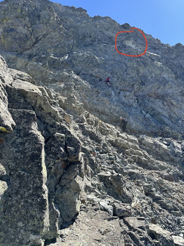
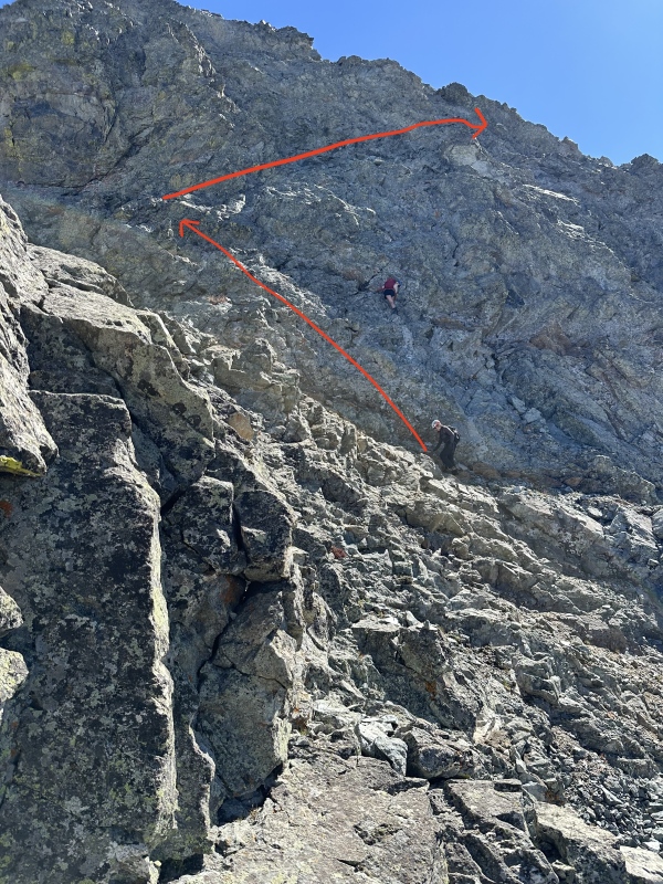
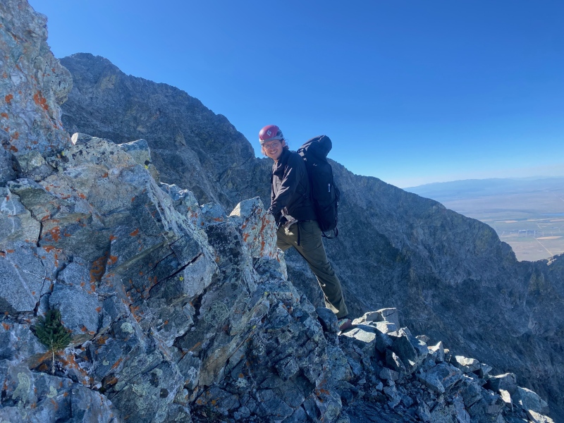
The key to the ledge system is a prominent blank-faced rock just above the crux (Fig 1). While it may not seem prominent from the photos, we had no trouble identifying it while on the climb. To access it, we zig-zagged up easy 3 terrain to the rock where we found the ledges (Fig 2).The ledges led climber's right all the way across the face and conveniently rejoined the standard route at a cairn. From there, it was an easy climb to the summit.
Fig. 1: This blank-facing rock is the key to the ledge system..Fig 2Fig. 3: Class 2 ledge
On the way down, we took a slightly different route, but the difficulty was the same, and we ended up in more or less the same place.
Fig. 4: Mason returning to the sun and to the standard route from the ledges
Some other thoughts on the route:
1) The exposure on the crux move is severe but not as "eye-popping" as I expected. If you don't want to climb exactly on the ridge, there's a very small slab that you can climb just to the right. The climbing "feels" a little more protected, but it's also a little more awkward. Mason took the direct route, and I opted for the slab.
2) Because we took the higher way on standard route pre-Hourglass, we didn't see the rusty staircase that daway8 mentions. In fact, we didn't encounter any of the landmarks he mentions. On the way up, we took a more direct line to the crux that didn't seem any more difficult. So long as one has good route-finding skills, there seem to be multiple paths available.
In the end, all three of us were grateful to have done the Indirect route over the Hourglass. As we rejoined the standard route below the couloir, we saw rocks shooting out of it like bullets and narrowly miss two climbers. For those considering which route to take, I'd recommend the Indirect so long as you feel comfortable on class 4 terrain. It's safer, less crowded, and overall more fun.
My GPS Tracks on Google Maps (made from a .GPX file upload):
It ought to be emphasized, if you take the upper route along the side of the ridge (the GPX from this website on the Hourglass route), getting to the ridge is less difficult than I imagined. The rock is loose in spots, but we went one gully to the right of the Nike Swoosh described in daway's report on the ascent. I personally found the gully above the swoosh (which we took on the descent) to be uncomfortably loose. The gully to the right (looking at the ridge) was considerably better to me. After the initial notch, we angled left and followed a prominent black band with a white stripe to reconnect with daway's route. This route is absolutely doable but needs more fine-tuning, I really enjoyed it. If there's a concerted effort to find the best route up to the ridge, this could make Little Bear a whole lot safer.
You said you "took a slightly different route down" - can you indicate some more on how the descent went? Was the route-finding ok? How was the exposed crux going down?
It's a little clearer in my GPX, number 22 on this list. We improv-ed a little on the way up below the ridge, then on the descent we kept the same route until we were maybe 60 feet below the ridge, at which point we descended via daway's route (the Nike Swoosh) to meet back up with the Hourglass trail.
The route finding getting to the ridge was harder than I expected, the route finding after the ridge was easier than I expected. Our route below the ridge probably wasn't the best one, but it goes. I imagine there are half a dozen potential routes one could take while keeping it class 4. Our route above the ridge is very solid and spits you out right on the Hourglass' final pitch.
The exposure on the crux was... interesting. I took a line just slightly to the right of ridge proper and didn't realize how exposed it was until I was at the top. The final move had my feet on the south side of the ridge which was a huge drop. On the way down, I followed Sean and Maja's route which keeps even further to the right (south) and finds a small grassy slab/ramp which is not as exposed, although I'd still call it a no-fall zone. The most difficult down climbing in my opinion was the first 50 feet descending from the ridge which had some light class 4 and some loose rock. Sean and Maja feel free to leave your thoughts too.
It is possible to combine the GPX data in this report, which seems optimum, with the subset of corresponding pictures in the previous two reports and make it an "official" route for Little Bear Peak? This would greatly simplify downloading it.
Madmattm pointed this out to me since I missed it when it was posted. Did the route with him today and having that white rock as the guide for the ledge system was exactly the landmark I was needing! I'll be updating my West Ridge Indirect report soon and may look into making this an "official" route once a few details are cleaned up.
Thanks for this awesome clue!
Caution: The information contained in this report may not be accurate and should not be the only resource used in preparation for your climb. Failure to have the necessary experience, physical conditioning, supplies or equipment can result in injury or death. 14ers.com and the author(s) of this report provide no warranties, either express or implied, that the information provided is accurate or reliable. By using the information provided, you agree to indemnify and hold harmless 14ers.com and the report author(s) with respect to any claims and demands against them, including any attorney fees and expenses. Please read the 14ers.com Safety and Disclaimer pages for more information.
Please respect private property: 14ers.com supports the rights of private landowners to determine how and by whom their land will be used. In Colorado, it is your responsibility to determine if land is private and to obtain the appropriate permission before entering the property.

")
")
")
")