| Report Type | Full |
| Peak(s) |
Granite Peak 12,807 |
| Date Posted | 09/05/2024 |
| Date Climbed | 09/01/2024 |
| Author | Codyhill1991 |
| Granite Peak, Montana |
|---|
|
Over Labor Day weekend, I climbed beautiful Granite Peak in Montana via the SW Ramp. This peak was a ton of fun and it was definitely challenging, but would be easily within the comfort zone of anyone who has done the harder CO 14ers. I used Hoot's trip report and GPX and would highly advise looking at that one; the report is thorough, and I believe the GPX is extremely helpful. I don't have one to share unfortunately. I started from the Upper Lady of the Lake trailhead. There's a lower trailhead right off the highway which looks like it would add a few miles, then the official upper Lady of the Lake TH 2 miles further up the road, and a third TH just a bit further up where you can cut off about a half mile of trail. The road was slow going but likely passable for most vehicles until the upper TH. I didn't bother going further, as I heard it gets a little rougher and the mileage saved wasn't much. The trailhead itself is small but there were about 10 cars parked on the grass around the trailhead and plenty of pullouts down the road. Trail is easy to follow and easy going for the first several miles. You pass Lady of the Lake and stay in the trees until about mile 5.5 when the views really start to open up, and once you get to Lone Elk Lake the scenery is consistently gorgeous. 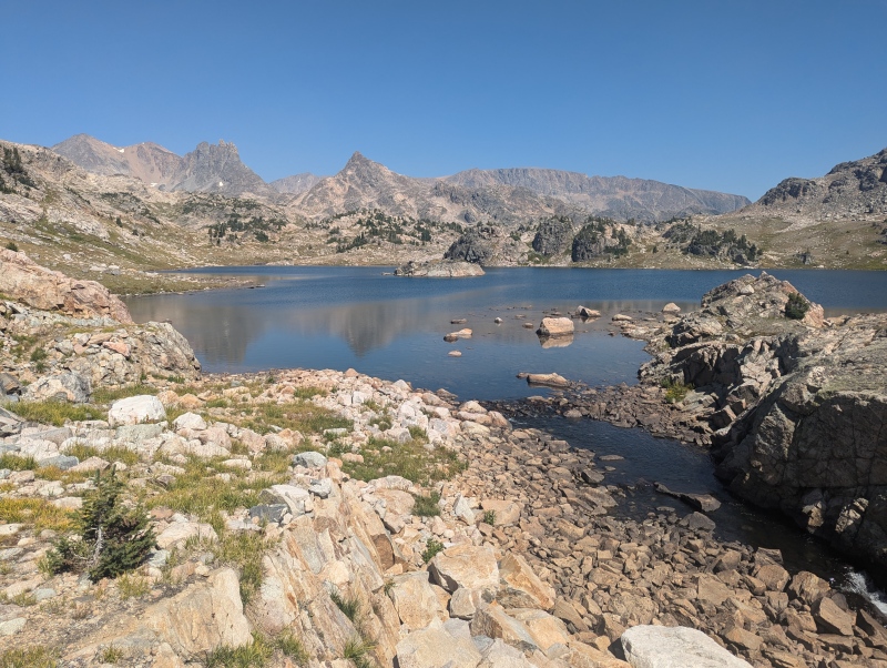
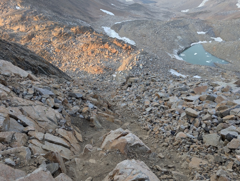
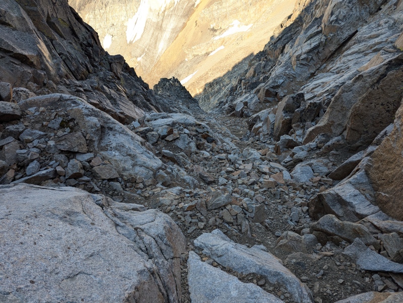
The trail was good up until this point; it starts to peter out significantly as you make your way around the left side of Lone Elk Lake, and then you catch only small snippets of trail and a handful of cairns for remainder of your hike. Wrap around Lone Elk Lake and then cross the lake's inlet and skirt the right side of the next lake (Rough Lake). The GPX or any map is helpful around here, as you need to re-cross the creek at some point and ascend a little hill to get to the Sky Top Lakes. There are tons of spectacular campsites all along these lakes and it was tempting to set up here, but I'd recommend getting much higher to make your summit day shorter. As others have noted, the terrain is slow going once you get to the middle of Sky Top Lakes basin. I did this in two days, but if you've got the time I think it would be a much more enjoyable experience to do it in three days - Next time I would do a high camp in the uppermost part of Sky Top Lakes basin the first night, and then after summiting I'd move camp for a second night down to Lone Elk or Rough Lake for a change of scenery and an easy hike out on the third morning. 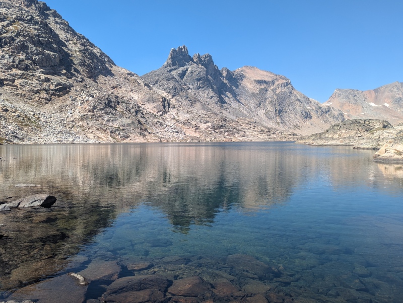
I set up a beautiful camp right after the second highest lake. I ran into a couple who had summited earlier that day and they said it had been really crowded, and rockfall was a huge concern. I was getting nervous about this; being Labor Day weekend I wasn't sure what to expect as far as crowds. On the hike up I had passed a group of 8 and I didn't want to end up in these steep, loose gullies below them. I have never had traditional weekends off work before this summer, so I'm still getting used to weekend crowds. I had hiked Mt Timp in Utah a few weeks ago with roughly four billion other humans with an average trail etiquette level of "poor", and I wondered if there'd be 30-40 people going after Granite the following morning. I had in mind the Hourglass on Little Bear and indeed the terrain ended up being similar. The area in which I was camped was so stunning that I told myself if there were too many people on the mountain and rockfall felt like a serious risk, I'd just call it a successful backpacking trip to the lakes and give myself permission to defer the summit attempt until a quieter day next summer. Thankfully this was a non-issue. I ended up running into only 4 other parties on the mountain, but you don't want to be up here with tons of people around because it is loose and messy. Several times in the evening before the climb, I could hear substantial rockfall all around the basin. From camp, you can see pretty much exactly where you need to go. A GPX track is useful for finding the easiest way, but everything from here up should be intuitive if you climb mountains regularly. 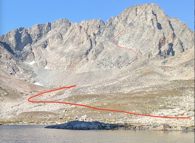
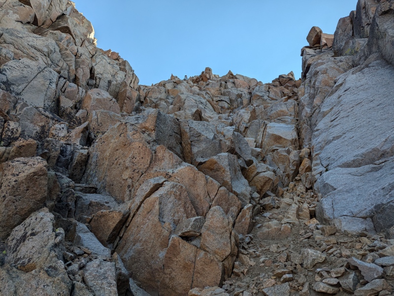
There is no trail, but just head on up to the low saddle between Granite and Cairn mountain, out of view on the right in the above image, and then the upper red line shows your approach to, and beginning of, the SW ramp. It looks, and is, messy getting to the start of the ramp, but it ended up being a little less terrible than it appeared from here. The dark slab pointed out in Hoot's trip report was a great spot to aim for the whole time. Everything above the lake is talus hopping, and when you get to the saddle you can see a very obvious gully that will take you up towards the dark slab. It reminded me of some of the terrain on the SW ridge on Sneffels - as is always the case, hugging the sides of the gully worked best. I clung to climber's right on the way up, and tried the other side on the way down but ended up crossing back over near the bottom on my descent. 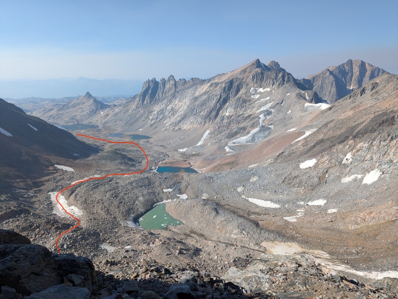
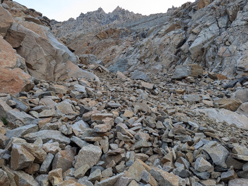
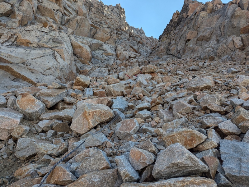
It is also fairly obvious where you turn right out of the top of the gully, at the top part of the dark slab, and enter the SW ramp. There is a clear start to the ramp and after that, the going is very obvious until right before you hit the ridge. Rockfall is still a concern at this point, but it's less loose than the gully you just exited. There are three spots with fixed ropes; the ropes are in awful condition and should be relied upon for nothing at all other than a visual cue of where to go, if you needed one - but the climbing around the ropes is easy enough (when dry). The middle rope's downclimb required a little bit of care, but while these little areas are steep they are not exposed and I never felt uncomfortable. The middle/upper part of the ramp was reminiscent of some of the climbing in the Hourglass on Little Bear, but longer. Definitely some bowling alley vibes. 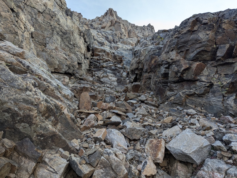
When you get to the top, there are a few ways to go. At this point I ran into the group of 8 that I'd seen the day before - they had summited early and were leaving the summit as I got there, but were descending via a slightly different path so I didn't talk to them. Once you reach the top of the ramp there are some cairns around. I would just say at this point to make some notes of where you're going because when you start to descend it could be easy to start going down the wrong way - though I imagine you'd catch your mistake pretty quickly. I ended up topping out on the ramp and going left a bit to wrap around the top of the mountain, topping out and then backtracking to the right a little bit to get to the summit proper. Views were hazy but wonderful! I had the summit to myself for 45 minutes at around 8:15 am - Montana holiday weekend crowds are different than those on the CO high peaks, I guess. 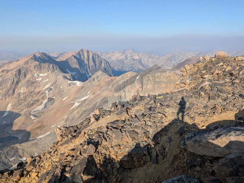
I descended using the cairns and just carefully retracing my steps. I passed a party of two close to the summit, one solo climber partway up the ramp, and a party of three back down at the bottom of the approach gully. None of the downclimbing was hard, but the gully especially required a lot of time and care to not rain rocks down or start scree surfing. Times: From camp in the morning, it took me 1 hour to get to the bottom of the approach gully, and another 1:20 to summit. A little longer than 2:20 to get down because I kept getting distracted by the beautiful scenery. Took a nice little nap and had some coffee at the uppermost lake before starting the slog out. Overall, a truly wonderful and fun climb! Thumbnails for uploaded photos (click to open slideshow): ")
")
")
")
")
")
")
")
")
")
")
")
")
")
")
|
| Comments or Questions |
|---|
|
|
Caution: The information contained in this report may not be accurate and should not be the only resource used in preparation for your climb. Failure to have the necessary experience, physical conditioning, supplies or equipment can result in injury or death. 14ers.com and the author(s) of this report provide no warranties, either express or implied, that the information provided is accurate or reliable. By using the information provided, you agree to indemnify and hold harmless 14ers.com and the report author(s) with respect to any claims and demands against them, including any attorney fees and expenses. Please read the 14ers.com Safety and Disclaimer pages for more information.
Please respect private property: 14ers.com supports the rights of private landowners to determine how and by whom their land will be used. In Colorado, it is your responsibility to determine if land is private and to obtain the appropriate permission before entering the property.


