Download Agreement, Release, and Acknowledgement of Risk:
You (the person requesting this file download) fully understand mountain climbing ("Activity") involves risks and dangers of serious bodily injury, including permanent disability, paralysis, and death ("Risks") and you fully accept and assume all such risks and all responsibility for losses, costs, and damages you incur as a result of your participation in this Activity.
You acknowledge that information in the file you have chosen to download may not be accurate and may contain errors. You agree to assume all risks when using this information and agree to release and discharge 14ers.com, 14ers Inc. and the author(s) of such information (collectively, the "Released Parties").
You hereby discharge the Released Parties from all damages, actions, claims and liabilities of any nature, specifically including, but not limited to, damages, actions, claims and liabilities arising from or related to the negligence of the Released Parties. You further agree to indemnify, hold harmless and defend 14ers.com, 14ers Inc. and each of the other Released Parties from and against any loss, damage, liability and expense, including costs and attorney fees, incurred by 14ers.com, 14ers Inc. or any of the other Released Parties as a result of you using information provided on the 14ers.com or 14ers Inc. websites.
You have read this agreement, fully understand its terms and intend it to be a complete and unconditional release of all liability to the greatest extent allowed by law and agree that if any portion of this agreement is held to be invalid the balance, notwithstanding, shall continue in full force and effect.
By clicking "OK" you agree to these terms. If you DO NOT agree, click "Cancel"...
And with that pretense, I did a few trips to look over some, perhaps "trouble" spots. My thought was that the traverse over the Three Apostles would be the crux of the whole ridge, and well: that didn't seem all that hard. Announcing my intentions seemed to also raise interest in others to give a try out as well - something I wasn't fully anticipating. Maybe it was that I had the idea that this was an easier objective than the aforementioned trips, or that I made comparisons to Nolans 14, and Nolans 14 is quite popular.
Then, one interested party showed me a first person GoPro video of a guy bailing off the ridgeline, between Birthday Peak and Mt. Harvard. The terrain looked fierce, I am not going to deny:
But I also knew how easy it was for GoPro footage to distort the terrain you're traveling on, and well (puffs up chest), I've been on some pretty difficult terrain out there. But the person in the video looked pretty competent, especially with their climbing skill (shown in other videos or in their Insta), so it seemed as if it would be wise to investigate this ridgeline first-hand. So, that's what I did!
I started my trip at the North Cottonwood Creek TH late in the afternoon and hiked up towards Kroenke Lake - because, hey: why not? Never been, seemed cool. I also wanted to see if there was a route up Yale south from around Kroenke Lake, as I dislike very much the avalanche gully the Nolans 14 route up the mountain takes and having a better alternative would be oh-so-nice. I didn't see anything worth pursuing in the fading light, so I kept going west on the trail, until I crested the Continental Divide. From there, I followed the Continental Divide south to Peak 12955, and hiked east up the west ridge of Mt. Yale.
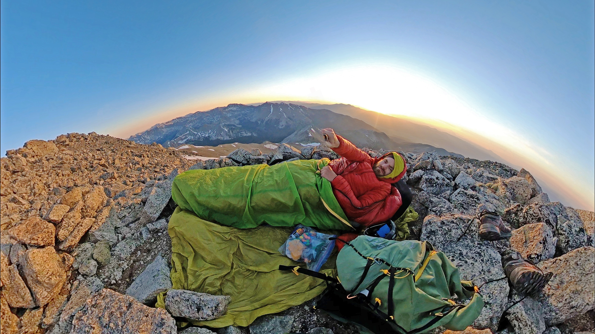
Why? Well, my thought was: since this ridge traverse trip was going to be so easy, I might as well throw some more difficulty in the way. How about summit all the 14ers and Centennials you can access that are right off the ridgeline? Seemed perfectly reasonable to me. So this was a recon of this route and of really this idea. Anyways, quality, albeit long, route to Mt. Yale, with one small Class 3 crux to negotiate, but nothing crazy. Too time consuming to consider for a Nolans run. Being close to midnight, it seemed prudent to stop for the night, and I slept fitfully on the summit in my shiver bivy until daybreak that morning.
Bivy on Mt. Yale
I backtracked and kept going north on the Continental Divide. After Birthday Peak (which was easy), the terrain gets a little more serious, and a few Class 3 sections are encountered. I noted that the rock wasn't altogether very trustworthy. Choss alert! This was slightly unexpected I guess, and I had to make sure to be a little careful about things, but still I enjoyed myself.
Then I got to the meat of the day while staring down the ridge that eventually lead to Mt. Harvard. If you look at this ridge from Horn Fork Basin, it does actually look doable, albeit somewhat steep and pointy. And that's fine, I've been on plenty of steep and pointy things. But what I wasn't anticipating was just how loose and chossy things were about to be.
This wasn't my first go-around in the Sawatch. I've done Ice Mountain before - and I had been under the impression that that was as bad as it got in the Sawatch. 14ers.com's own HeadSizedBurrito and I also reconnoitered the ridgeline from Mt. Huron to Ice Mountain earlier in the year (as HSB also wanted to do this ridge traverse!), and although there were certainly cruxes, it seemed fairly reasonable. I though the Northeast Ridge of North Apostle was quite a hidden classic. I've also done the Mt. Hope - La Plata ridge traverse (didn't know that was a thing, didja?!) which although a challenge route-finding wise, certainly was doable. I've done the east ridge of Missouri at least three times and I may of even said that I found it, "enjoyable".
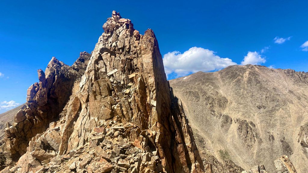
A pretty serious tower on La Plata's curving south ridge
Nothing, nothing compared to what I found off of Harvard's southwest ridge.
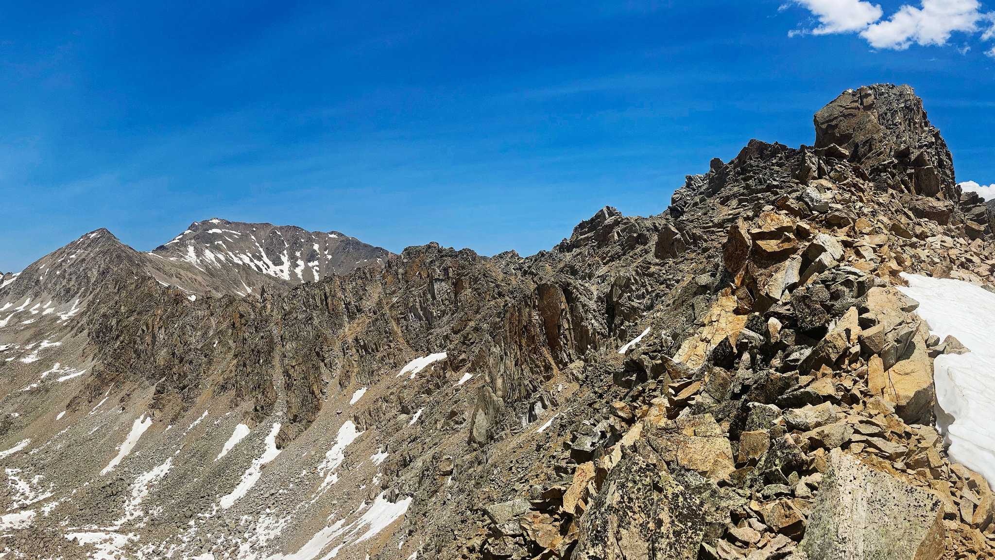
The ridge to Mt. Harvard
Perhaps the main problem with the ridge is everything is in a state of almost toppling over, so nothing can be trusted. You reach out for a handhold, and it breaks off in your hand. You take a step, and the ground shifts below you. Bad sensations. I didn't get all that far at all! I bailed after climbing up the first tower - which wasn't hard, but was still not all that easy in a sense, 'cause I wasn't sure the handholds I used to get up would be there to get down. On the summit of my little pinnacle, I found a very worrisome sight: a rap anchor made out of old nylon tat and two nonlocking carabiners - all setup on a small, detached block. So, somebody was up here, but boy could it have been quite a few years ago. Not having a rope of my own, I declined using the rap anchor for anything - the tower itself didn't look like something you could downclimb.
I hemmed and hawed a little bit - sometimes it's nice to give yourself a second chance - was it just nerves? I've done many a trailrunning-shoe alpine solo by bouldering out a tough section until I had the confidence to just go for the whole thing. Traversing the ridge from Columbia to Harvard took a few minutes to totally commit to the perfect hand jam crack, even though I couldn't foot jam with the kicks I had! But I got through the thing just fine. I just couldn't come up with a great way to get through what I saw in front of me.
So I bailed down a talus field/rock glacier all the way to Horn Fork Basin. Even that talus field was unnerving - what is up with this area? The ridgeline even here looked impenetrable even if you were to drop down - it's quite a sight - and really only one I'd marvel in passing after finished up Harvard/Columbia.
Once down Horn Fork Basin, I took a nap, took lunch and thought: "well, still got daylight!" and hiked up Mt. Columbia - more to check out the new CFI trail than anything. It's good! Until it's not anymore, so I hope they have the time/budge to complete it to the top (if that's the plan). From Columbia, it was too difficult through the forest fire haze and late afternoon sun to really study the ridgeline that couldn't cross. Maybe I thought, it would be best to stick to that side? But I'm doubting that idea.After making a brew, I hiked down to the trailhead, made my bivy, and rolled out in the morning to catch my bus.
So as far as I know, no one has done the full ridgeline from Birthday Peak to Mt. Harvard, but there's strong evidence that someone has been up there given the rap anchor, but I haven't found out how, when, and how far they gotten. I can't think of an easy bail off the ridge once you go forward - certainly none on the Bear Lake/Horn Fork Basin side. Maybe one on the Texas Creek side.
Scott, the guy who initially showed me this video did go on his Sawatch ridge traverse trip - with rope in tow, skipped this section, electing to drop into Texas Creek Basin, find the CDT and rejoin the route at Lake Ann Pass, north of the Three Apostles. He recounts using the rope he brought along many times. I anxiously look forward to HeadSizedBurrito's trip report.
Will I be back? Likely! I still want to see this project finished in the way I envisioned: sticking to the ridgeline as best as possible, without dropping down and making this project merely a high route. This is absolutely the crux of the whole trip, though, with some serious terrain between Peak 13517 and West Apostle afterwards.
Don't underestimate the Sawatch!
My GPS Tracks on Google Maps (made from a .GPX file upload):
Thanks for posting this, Justin, really interesting. Probably an example of how much traffic cleans up a route, i.e. venture off a route that's had traffic and the looseness can be significant, eye opening. I recall beng on Lizard Head in the 90's and stunned with how loose it was. Scroll forward 25+ years and it's super solid now, a different climb. Great to see you getting after something that's obviously way off the beaten path. Good luck if you revisit this testpiece.
It's good! Until it's not anymore 11/11/2021 11:38am
that sums up the new CFI route quite nicely. i guess i just chalked up the "unfinished" portion between construction and the ridge to be character-building...? best of luck on your next attempt of this route!
Nice report, makes me feel a little better about my own late report! I'd be very interested if anyone else knows more about this section. When I looked at it I knew it was best to detour, especially since I knew justiner had already bailed on it and I'm not nearly as competent in that kind of terrain as he is.
For a little teaser to hijack this report, I followed the divide from Monarch Pass to Lake Ann Pass, with the minor detour of this section. Hopefully I can get my report up in about two weeks when I have some free time.
Caution: The information contained in this report may not be accurate and should not be the only resource used in preparation for your climb. Failure to have the necessary experience, physical conditioning, supplies or equipment can result in injury or death. 14ers.com and the author(s) of this report provide no warranties, either express or implied, that the information provided is accurate or reliable. By using the information provided, you agree to indemnify and hold harmless 14ers.com and the report author(s) with respect to any claims and demands against them, including any attorney fees and expenses. Please read the 14ers.com Safety and Disclaimer pages for more information.
Please respect private property: 14ers.com supports the rights of private landowners to determine how and by whom their land will be used. In Colorado, it is your responsibility to determine if land is private and to obtain the appropriate permission before entering the property.