For this year's annual Colorado 14ers hike(s) we decided it was time to take on the Bells and I really wanted to do the traverse.
We had to reserve our bus ride in from Aspen Highlands well in advance...4 of us on this trip - pictured below (left to right) - Bob, Ty, Bryant, Joe.

We spent Saturday night at Ami's Campground in Glenwood Springs, got up early Sunday morning and got on the 8am bus for Maroon Lake.
The weather was perfect and expected to remain so for the next couple of days. We couldn't have planned it any better: mild temperatures
and no rain in sight.
We hiked in and managed to fit 4 tents at campsite #5 near Crater Lake. I thought that being Labor Day weekend, the campsites might be in
short supply, but strangely, there were several to be found. Overall, I was also surprised at how few people were hiking the Bells. Almost
everyone we passed and talked to was not climbing the mountains but rather doing the various trail hikes...all fine with me...fewer people
to worry about with the loose rock!
Our plan was to hike in Sunday, get a campsite and then climb the Bells on Labor Day Monday (Sept 6) and that's exactly what we did.
South Maroon (Maroon Peak):
We started our hike up South Maroon slightly later than I had hoped. It was about 6am when we left our campsite.
I would consider myself a fairly slow hiker so I knew this late start might be an issue if I wanted to do the traverse, but with the weather
not being an issue, I really didn't have any concerns.
We started our slog up the 2800' of suck to the ridge of South Maroon Peak and arrived at the ridge around 11:30am. We took some pictures,
ate a little food and then I set off for the summit of South Maroon (or should I be calling this Maroon Peak..anyway, you get the idea).
The rest of my crew was content with the views from the ridge so I set off for the summit on my own at roughly 11:45am. There were only
two climbers ahead of me (that I knew of) and one of them mentioned that they also wanted to do the traverse, though they were a solid 30 minutes
ahead of me at that point so I was thinking I would be doing the traverse alone.
After a short ridge hike, I caught up to Kevin (whom I met minutes earlier with my crew) at the chimney. Kevin was clearly a faster hiker than
me and I didn't want to slow him down, but he was kind enough to stay within visual range as we moved up the rest of the hike.
After the chimney, I went up gully #1, then switched over to gully #2 before going around Robot Rock and up the final gully. For the final
gully I broke out my trekking poles. I felt they helped alot!
VIDEO (too bad the embeded video links are not working!!): South Maroon (Ascent)
I had printed the route from 14ers.com which helped keep me on track the whole way up.
I made it to the summit of South Maroon (Maroon Peak) at 2pm (so it took me just over 2 hours to get there...and that's without any route finding
issues...just me being a slow hiker).
At the summit was Regan and Kevin. We took a few pictures and then Regan and I set off for North Maroon across the fabled traverse.
I had watched plenty of videos of this traverse so I felt very confident knowing where to go and probably just as important, where not to go.
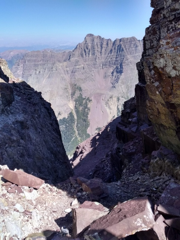
Maroon Bells Traverse:
I will say that seeing the traverse in person was much more dramatic that seeing on video (of course). The hike down to the Bell Cord looked more
steep in person than on video, but I guess that is to be expected.
We hiked all the way down to the Bell Cord, then a class 4, 30-40' downclimb at the end of the ridge near the Bell Cord.
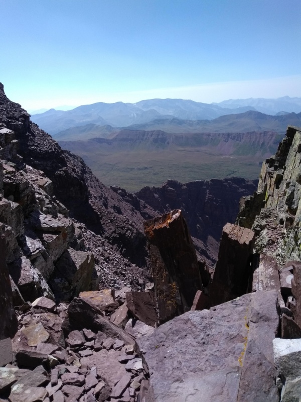
Here's a few shots from the Bell Cord looking toward Pyramid and the other was (toward Snowmass).
VIDEO (too bad the embeded video links are not working!!): Downclimbing to the Bell Cord
Here is a picture looking up Spire #1 and a video of us (Regan and I) climbing it.
.
VIDEO (too bad the embeded video links are not working!!): Spire #1
We started the ascent of Spire #1 head on, going straight up 2 two successive ledges. On the second ledge, we went slightly left to another 20'
chimney climb before going back right to the Bell Cord, where we finished with a direct climb to reach the top of Spire #1.
From here, we walked along a narrow (not quite cat-walk) ridge and then descended to the base of Spire #2. We navigated to the left, following a
couple carins and then hiked directly up and back toward the traverse ridge proper. All of this, I would say was class 3. At this point we were
half way up Spire #2, where there seems to typically be a little grass on the narrow and heavily exposed ledges. At this point we zig-zagged up
maybe 10 more feet on the Maroon Creek side of the traverse before coming to another narrow ledge with a carin. This marks the start of the crux
section up Spire #2. You go straight up beneath a protruding rock ledge. This would be the class 5 section of the traverse with serious exposure.
Honestly, it was awesome! This clip below shows Regan doing this section like a boss while I merely survived it (lol).
VIDEO (too bad the embeded video links are not working!!): Spire #2
From here, there was another ridge walk and then we ascended a final 25' class 5 chimney on the left side of the ridge. There's actually two
chimney's to choose from. We took the first.
After this there another ridge walk, with the "leap of faith" notch to get past (no...I didn't jump it as I was battling leg cramps and there was
0 margin for error on that leap).
Next comes a big rock block which we navigated around on the right (Maroon Creek) side before coming to the final push up to the summit of North
Maroon. We headed toward a white rock band then went slightly right and up two more rock walls before hitting the summit of North Maroon (4:30pm).
VIDEO (too bad the embeded video links are not working!!): Spire #3
VIDEO (too bad the embeded video links are not working!!): North Maroon Summit Ridge
It took 2.5 hours but that was mostly because I had to take some pictures along the way and re-hydrate myself as both my legs were cramping (got to
work on my conditioning).
Yes, that is rather late to be on a summit of a mountain like this but we knew the weather was going to be fine and we figured it would allow for
enough time to get off the trickier part of the mountain before it got dark.
North Maroon (Descent):
VIDEO (too bad the embeded video links are not working!!): Descent from North Maroon
I had printed off 14ers.com route description of North Maroon and that really came in handy (seeing routes down the gullys). I also had the
14ers.com GPS tracks which were a life saver. This was the part of the hike that I was most worried about, because I would be descending a section
that I had not climbed so having both the tracks and trip report was most useful.
We took the initial ridge down toward Maroon Creek side before coming to "The Precipass". You'll see a carin marking the area to descend about mid-way on the
on the precipass. From there we dropped down to the left, scrambling towad the crux move on North Maroon (the chimney - a 30 foot hard class 4
maybe low class 5 section).
From here we continued down toward the ridge of gully #2 (yes, go to the right here, down the gully even though there are carins on the left side of
this ridge. The gully we went down is the right way. You'll descend half way down and look toward the left ridge line for a carin. That's the spot
to cross the ridge into the 1st gully.
Once in the 1st gully (labeled as such in trip reports that describe the ascent of the mountain), you'll drop down and look for a narrow path around the
tree line (that's where you cross the ridge and enter an easy class 2 path toward the boulder field.
Since I had not gone through this boulder field going up and the fact that it was getting dark at this point made finding the right way across a little
tricky. There are a few carins along the way which help, but what really saved me were my GPS tracks.
After getting across the boulder field, you're home free. It was completely dark for me at this point and I was out of water. Luckily there was a
nice stream where I stopped and re-filtered water, filling my 3L bladder and my 1L spare bottle (I knew I wouldn't want to go filter water the next
morning).
I finally arrived back at my campsite at 9:30pm. Yeah..I know, I'm slow...but I made it back safely, so I was happy. Actually, I was exhausted.
Really grateful my crew made it back safely AND did not panic about me being late to return. They said they ran into Kevin on their descent of
South Maroon and he told them that Regan and I were doing the traverse so they expected me to get back late. Plus, Regan had a nice satcom devise
that would allow for communications in case of emergency.
It was really great meeting both Kevin and Regan on the way. I stand in awe of the conditioning and skills of these and other great climbers.
I've now climbed numerous tough Colorado 14ers including: Capitol, Little Bear, Pyramid, Crestone Needle, Longs. I know many say that Capitol is
the toughest and some argue it's Little Bear, but for me, I felt South Maroon was the toughest. The reason: both Capitol and Little Bear were
relatively short climbs from our campsite (8 miles and 7 miles round trip respectively from the campsite). South Maroon (Maroon Peak) was probably
more like 9.5 miles round trip so that little extra mileage really wiped me out.
Yes, lake como road is a killer, but if you do that as we did (the day before and camp before summiting), it makes those hikes a little easier in
my opinion. Feel free to share your opinions as well below.
Super glad that I had my crew with me and look forward to hiking with them again and again.
Hope you find this trip report useful as well as the pictures and videos.
")
")
")
")
")
")
")
")
")
")
")