| Report Type | Full |
| Peak(s) |
Crestone Peak - 14,299 feet Crestone Needle - 14,196 feet "East Crestone" - 14,298 feet Little Bear Peak - 14,041 feet Blanca Peak - 14,350 feet Ellingwood Point - 14,057 feet |
| Date Posted | 09/11/2020 |
| Modified | 08/14/2023 |
| Date Climbed | 09/05/2020 |
| Author | ellenmseb |
| Finishing the Great Traverses with much love for Cottonwood approach. | ||||||||||||||||||||||||||||||||||||||||||||||||||||||||||||||||||
|---|---|---|---|---|---|---|---|---|---|---|---|---|---|---|---|---|---|---|---|---|---|---|---|---|---|---|---|---|---|---|---|---|---|---|---|---|---|---|---|---|---|---|---|---|---|---|---|---|---|---|---|---|---|---|---|---|---|---|---|---|---|---|---|---|---|---|
|
I took advantage of this Labor Day weekend's great weather to finish the Great Traverses! This was a great capstone for this season's challenging climbs, which appear to be ending early with heavy snow outside my window as I type. My brutally honest splits:
I am a slow hiker. Normally I would say "moderately slow", but these 2 days can be characterized as "extremely slow" because I was often solo (except for the sections uphill of Lake Como) and needed to conserve energy on these long days. You can use these for extreme upper-bounds for predicted climb times! Traverse times:
Crestones Traverse via Cottonwood Creek The biggest beta in this trip report is: Cottonwood Creek approach has been unfairly maligned as a miserable, deadfallen, scrambly bushwhack! In fact, there is only a short bushwhack, deadfall has been mostly cut through, and slabby sections are shockingly well-cairned! Cottonwood Creek approach is quite pleasant! It was certainly the right choice for my itinerary (day-hiking, traverse, and already did South Colony Lakes). I can recommend Cottonwood Creek only in the following circumstances:
First of all, Cottonwood Creek is 2wd accessible. I know this because I first drove an Outback, which magically showed every warning light on returning (turns out this was because I didn't tighten the gas cap??) then drove an Accord back to retrieve my forgotten hiking poles. 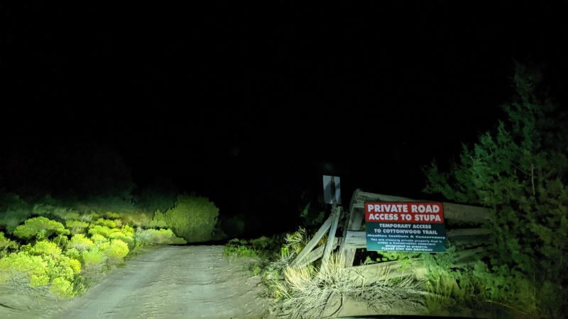
I can't explain exactly why I love the Cottonwood Creek approach so much. It just seems so natural and a different kind of woods than I normally walk through on the way to 14ers. in contrast, the South Colony Lakes approach is a 4wd road, even past the 4wd parking lot. Cottonwood seems like a nature walk somewhere exotic like the East Coast or Texas. I saw 2 female sage grouse, or the same grouse twice. I passed by 3 waterfalls. 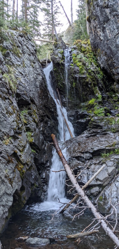 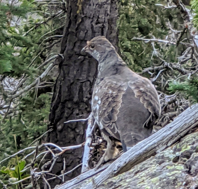
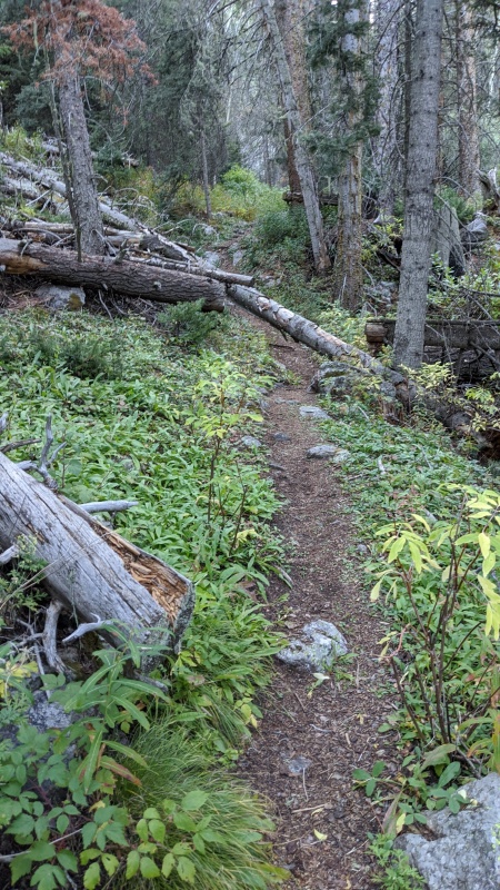
One tip about the approach: On slabby sections, the areas where water sometimes flows (even if it is not flowing now) have been polished and are slippery. Avoid these sections and go to the side instead. Counterintuitively, the worst bushwhacking is above 12k. Bushwhacking through willows (not forest), and not the worst willow-whacking I've done. This is where the real "scrambly" part of the approach starts.
Summiting Crestone Peak went uneventfully. We're so pampered by the water available at 13.3k in September! I had wondered about Northeast Crestone and East Crestone. A trip report claimed that NE crestone was 3rd or 4th class. An experienced traverser I chatted with said it was exposed 5th class. From looking at it, the line up to NE crestone didn't look bad. But, how to get to the base of NE crestone? The trip report's route was to traverse horizontally over from the Crestone-E Crestone saddle to the E Crestone-NE Crestone saddle. But this looked too steep, exposed and without-holds for my taste. So I instead started downclimbing from E crestone. However, this downclimb soon became too smooth, also lacking holds. Furthermore, even if I successfully summited NE crestone, I might get stuck and unable to downclimb. So I gave up, and very easily upclimbed the route from E crestone that I had downclimbed only with extreme difficulty. I guess this counts as my first failed 14er summit. The downclimb from Crestone Peak seemed to go on forever. Somehow without noticing, I apparently gained 200ft. The first 4 ways I tried to get back down to route, cliffed out. The 5th way worked. But the adrenaline rush from being cliffed out wore off, combined with lack of food, I hit the wall hard! I could barely put 1 foot in front of the other. The universe toyed with me when I accidentally kicked my helmet down a gully! mercifully, it only tumbled 100ft. This happened at the worst possible time, before the 1st of 3 cruxes, the 5.2 bulge. But after an hour of moving extremely slowly & long breaks, I felt better. Even at the end of the day and an even longer day on Blanca, I never felt that exhausted. 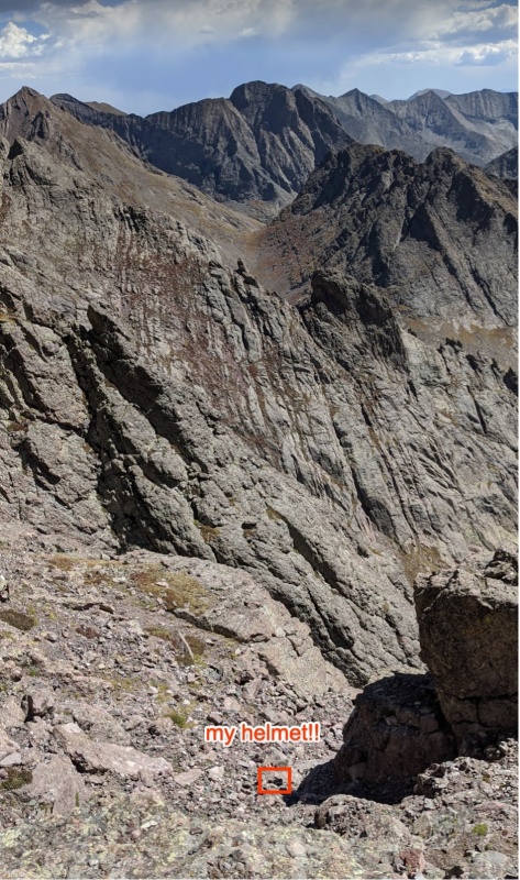
Among the 3 cruxes:
From Crestone Needle, I could see the traverse that awaited me 2 days later: 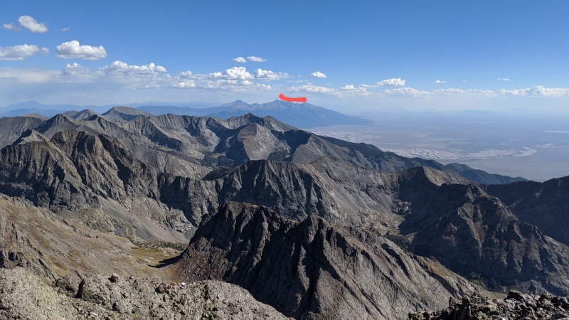
Shout-out to the absolute beast who learned where the traverse route was upon seeing me come up it; heard me opine that a reverse-traverse requires a rappel; and then casually down-scrambled the crux and continued on to Crestone Peak at 4pm. After lounging on Crestone Needle until 4:30pm, I suddenly remembered that my headlamp had been dim even that morning! I didn't charge it because I was only starting at 5am, but didn't consider that it would take me until after dark to return! September problems. I rushed down as fast as possible while making sure to descend the correct gully. The headlamp indeed became useless with 3 miles of shaded, moonless hiking remaining. I was on the verge of panic because I didn't know how long my 3 backup light sources would last. I could see literally nothing without a light source. I would've been reduced to crawling. I always pack to survive an emergency bivy, but the prospect didn't seem appealing. My small pen light burnt out. Thankfully, my battery pack is terrible as a battery pack, but great as a flashlight! I invented the pantslamp in order to keep both hands free for poles. 
Little Bear NW Face --> Blanca --> Ellingwood The Little Bear-Blanca traverse is indeed by far the most difficult of the traverses! But it's an enjoyable scramble, a great test piece, and for those of us who can either endure extremely long days or drive to 10k, it can ensure you only have to walk up Lake Como Road once, even without a heavy pack. Managed to keep this day in the domain of type 1 fun! Adrienne Jacobi, met on Colorado 14er Ladies, was an AMAZING partner on this route & deserves all the credit for its success and waiting for me to bumble about on the scrambles! Little Bear NW Face Unlike smarter individuals who can sleep in tents, I day-hiked this from 8k. (I think the Outback could've made it to 8800', but drove the Accord instead in fear of Outback's aforementioned warning lights.) But, the slog up Lake Como Road was almost pleasant because of the cool temperature and bright moon reflecting off white rocks! I went headlampless half the time. It felt like experiencing the desert night the way it was meant to be seen. I recommend doing this approach pre-dawn because I didn't even need a jacket at 2am in September. it must be sweltering during the day. 
We chose to take Little Bear's NW face based on advice in this thread. After doing it, I have no particularly strong feelings about NW face, it's a perfectly fine way to get up Little Bear. I referred to this trip report for the NW face route. Some of the moves were pretty tough, but could've been easier if I picked a better line and stayed better on-route. 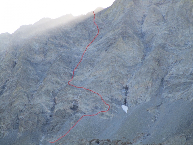
My original motivation to take NW face is that I was scared of the initial downclimb from Little Bear, which had been described as "the first crux" or even "the crux" of the traverse. That downclimb would be easier after having upclimbed it from NW face. However, the downclimb is in fact not very difficult compared to the rest of the traverse (stay far right as ascending/left as descending). So, don't choose NW face for this reason. Hourglass is probably the easiest option, but common sense says to avoid it on holiday weekends. For us, on Labor Day, Hourglass didn't seem that crowded; we only saw Scott P's party come up from Hourglass. Insanely, Little Bear counts among only 4 14ers that I want to repeat, so that I can experience the infamous Hourglass. (the other 3 are Longs via Loft, Torreys via Kelso, and Sneffels with better weather). SW ridge sounds terrible, pushes your last water source earlier, and adds extra elevation gain to the day. So tl;dr Hourglass and NW ridge both look like reasonable ways to start your traverse day. 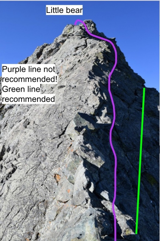
Little Bear-Blanca Traverse 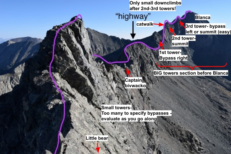
Don't underestimate the length and commitment of this traverse, especially if your experience is similar to mine (i.e., haven't done any harder climbing than the 14er standard routes & traverses). It is indeed extremely long, contains a huge number of C4-5.0 moves, and there is no escape from the ridge. On the plus side, the moves are no harder than the other traverses, and routefinding is relatively easy. And it is rewarding. For the traverse, I can't hope to provide as good route descriptions as these trip reports that I relied on:
These resources are helpful, but I was confused about where the various sections are in relation to each other. Here is the order.
The Catwalk is very exposed and marks the end of difficult scrambling. If you made it here, you're finally home free! 
best picture of me ever taken on a 14er, because you can't see my face. 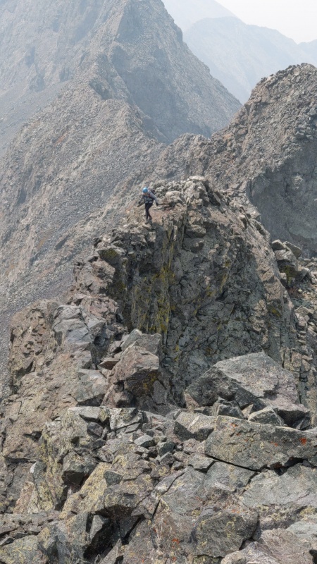
Ellingwood Point 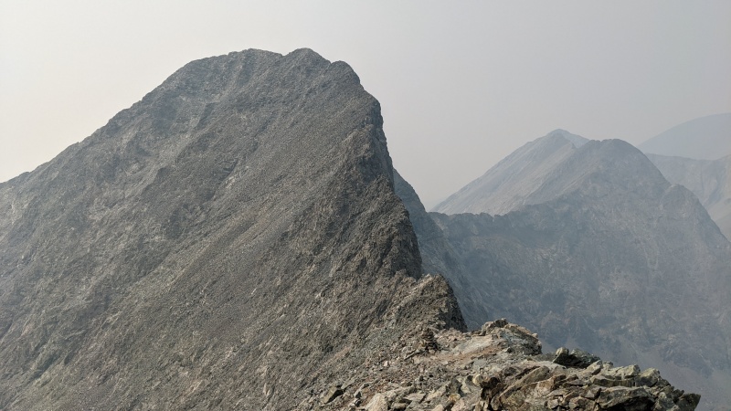
Actually the most physical exertion of the day was those 500ft up to Ellingwood Point. There was no difficult scrambling to slow us down, and the late hour pushed us to summit as fast as possible (which was still very slow). Huffing and puffing thick smoke. On the descent, we couldn't find a trail for a long time and hopped on small talus. so don't treat the GPX as gospel. Felt kind of depressed at this point because of the smoke and late hour. 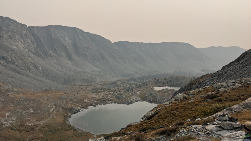
After doing the three 5.easy traverses, I've reached the limit of what I should safely free solo. I got inspired by several partners who actually started from technical climbing and then added scrambling to their repertoire. Plus, I normally live in California, which has few C3-4 scrambles (mostly 8 hours away from home in the eastern sierra), but many world-class technical climbs, even close to home. Therefore, I've decided to learn how to climb with ropes in the gym over the winter. Maybe when I come back to visit Colorado next I can do some more cool 5.medium routes like Longs Cables, Vestal Wham Ridge, or simply the Flatirons :) Thumbnails for uploaded photos (click to open slideshow): ")
")
")
")
")
")
")
")
")
")
")
")
")
")
")
")
")
")
|
| Comments or Questions | |||||||||||||||||||||
|---|---|---|---|---|---|---|---|---|---|---|---|---|---|---|---|---|---|---|---|---|---|
|
Caution: The information contained in this report may not be accurate and should not be the only resource used in preparation for your climb. Failure to have the necessary experience, physical conditioning, supplies or equipment can result in injury or death. 14ers.com and the author(s) of this report provide no warranties, either express or implied, that the information provided is accurate or reliable. By using the information provided, you agree to indemnify and hold harmless 14ers.com and the report author(s) with respect to any claims and demands against them, including any attorney fees and expenses. Please read the 14ers.com Safety and Disclaimer pages for more information.
Please respect private property: 14ers.com supports the rights of private landowners to determine how and by whom their land will be used. In Colorado, it is your responsibility to determine if land is private and to obtain the appropriate permission before entering the property.


