| Report Type | Full |
| Peak(s) |
Mt. Antero - 14,271 feet |
| Date Posted | 08/09/2020 |
| Date Climbed | 08/08/2020 |
| Author | KMoore32 |
| My Dear Old Anty - Antero via Raspberry Gulch |
|---|
|
As many others have stated before, Antero is a peak I have been sort of dreading because of the long 15+ mile slog up either the 4x4 road or the Little Brown's Creek route. That is.. until I discovered the existence of the east ridge option from Raspberry Gulch. This was an adventurous, scenic, and pretty challenging way to ascend Antero where you have virtually no chance of seeing anyone else until the summit. Drive to the trailhead: The road up to the Raspberry Gulch TH is definitely a little rough in spots and I wouldn't recommend attempting to get up here in a sedan or a 2WD car, but 4x4 is not required. It gets very narrow in spots and there are some deep ruts and pointy rocks where some kind of clearance is probably necessary. There is a gate you will need to open and close. We took my Mazda AWD with 8.1 inch clearance and it did fine and only scraped once or twice. On the 14er road rating system I'd probably say it was a 3 out of 6, especially the last mile. It ends at a very obvious roundabout with the trail directly in front of you behind a metal sign saying 'motorized vehicles not allowed beyond this point'. Stats: We logged around 9.5 miles, but that can probably be reduced by a half mile or so if you climb with maximum efficiency on the ridge. Logged 4850 feet of gain. Time: We got to the summit in exactly 4 hours 20 min from the car (starting at 5:50 AM and summiting at 10:10 AM). We lollygagged a bit on the way down so the descent took us 3 hours 15 min (left summit at 10:40 AM, back to car at 1:55 PM). All times include breaks. Trailhead starting elevation is 9595 feet. You begin this hike on an old mining access road to the sites on Mine Mountain, which is an important landmark on this route. After 1.1 miles on the only trail you'll see all day, you arrive at the saddle (10,500 ft) between Mine Mountain and the trail-less start of the east ridge up to Antero. This next section is possibly the hardest part of the day. From here, you ascend directly west up the eastern slopes of the edge of the ridge. And I mean UP. You gain 1000 feet over 0.4 mile from the 1.1 mile mark to the 1.5 mile mark. Though it is a trail-less bushwhack up to your next checkpoint at 11,500 ft, the forest isn't really too dense so getting scratched up isn't too much of a concern. The steepness however, which is downright silly, will definitely make you question why you chose to take this route.. but fear not! The hike becomes much more enjoyable shortly after. At 1.5 miles in and 11,500 ft, you reach a bluff of sorts. You may see a cairn or two around here, but there still isn't really an established trail. You can opt to either take a very faint herd path on the north side of this bluff where there are amazing views of the Chalk Cliffs and Mt Princeton, or just attack it directly. We chose to just stay as central as possible and keep ascending through the trees. It flattens out (a bit) momentarily around 11,700 ft as you steadily gain the last several hundred feet until treeline. At 2.1 miles in and around 12,000 feet, you reach treeline. 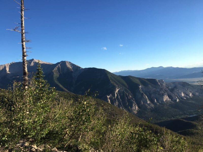

Once you get to treeline, your next checkpoint is the first bump on the ridge around 12,500 ft and 2.5 miles in. Once you arrive at this point, the rest of your route becomes abundantly obvious as you see the entirety of the long east ridge you'll be climbing. The next notable landmark will be the point at 13,100 ft. and 3.2 miles in. Due to some strong wind gusts, we opted to stick to the east (left) of this bump on the ascent, but we stayed ridge proper on the descent and I highly recommend sticking on the ridge proper for the duration of the hike if you are able to. The talus does become quite annoying at times. We took a quick rest around 13,200 ft before ascending this next northern stretch of the east ridge. It is probably the most technical part of the climb, but it never exceeds class 2+. Be careful on this section though from 13,100 to 13,700 (3.2 to 3.6 miles), as many of the rocks are very unstable. The closer you stick to the ridge proper, the more stable the rock- as is typically the case. 


Once on top of this section at 3.6 miles in and 13,700 ft, you realize that the final 0.7 mile to the summit isn't nearly as flat as it looks from 13,100. This however was definitely my favorite section of the ridge. You get amazing views both of Antero itself and also south to Little Brown's Creek, as well as more southwesterly to the gem mining operations happening on the southern flank of Antero. 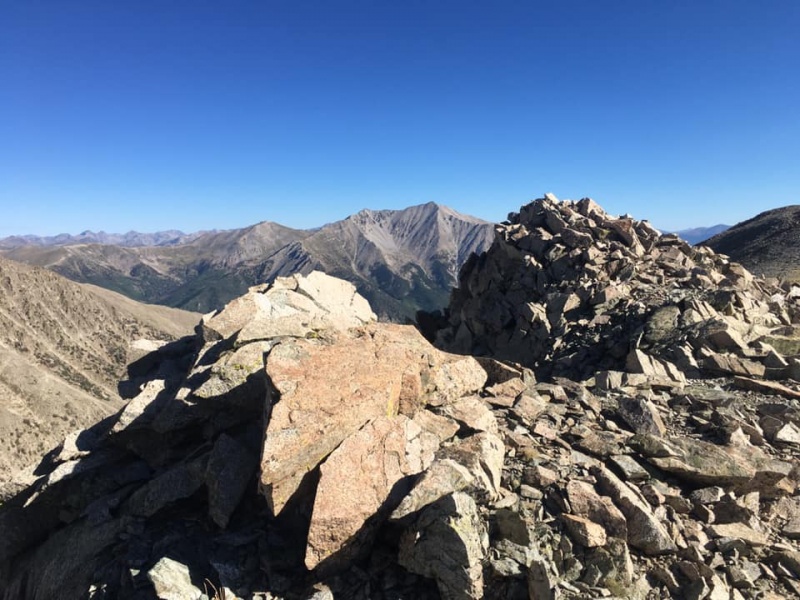
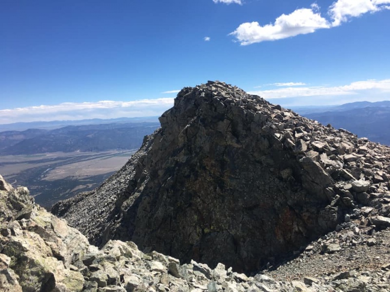
The final 0.7 mile and 600 feet of gain are super enjoyable, and the rock is a bit more forgiving than on the way up from 13,100 to 13,700. The final bit up to the summit is slightly steeper but totally manageable, gaining the final 300 feet in a quarter mile. Once you arrive at the summit, you can look back on the entirety of the route you've completed and feel very satisfied with what you've just achieved.

Some final notes: Do be careful to complete the entire ridge on the descent back into the trees. It will be tempting to start descending (south) too early when you get near the trees, and this could lead to a lot more work with re-finding the old mining road back to your car. This is where it really helps to keep Mine Mountain in sight, and to keep it very central in your view on the way down. A GPS tracker really helps with this section too as you re-find the bluff just below treeline and descend the steep section to the saddle between the end of the ridge and Mine Mountain. This was honestly a fantastic day, one of my favorite 14er routes to date. It will make you work a bit, but you will have complete solitude and breathtaking views for most of the journey. Enjoy! Thumbnails for uploaded photos (click to open slideshow): ")
")
")
")
")
")
")
")
")
")
")
")
")
")
")
")
")
")
")
")
")
")
")
")
")
|
| Comments or Questions | |||
|---|---|---|---|
|
Caution: The information contained in this report may not be accurate and should not be the only resource used in preparation for your climb. Failure to have the necessary experience, physical conditioning, supplies or equipment can result in injury or death. 14ers.com and the author(s) of this report provide no warranties, either express or implied, that the information provided is accurate or reliable. By using the information provided, you agree to indemnify and hold harmless 14ers.com and the report author(s) with respect to any claims and demands against them, including any attorney fees and expenses. Please read the 14ers.com Safety and Disclaimer pages for more information.
Please respect private property: 14ers.com supports the rights of private landowners to determine how and by whom their land will be used. In Colorado, it is your responsibility to determine if land is private and to obtain the appropriate permission before entering the property.


