Download Agreement, Release, and Acknowledgement of Risk:
You (the person requesting this file download) fully understand mountain climbing ("Activity") involves risks and dangers of serious bodily injury, including permanent disability, paralysis, and death ("Risks") and you fully accept and assume all such risks and all responsibility for losses, costs, and damages you incur as a result of your participation in this Activity.
You acknowledge that information in the file you have chosen to download may not be accurate and may contain errors. You agree to assume all risks when using this information and agree to release and discharge 14ers.com, 14ers Inc. and the author(s) of such information (collectively, the "Released Parties").
You hereby discharge the Released Parties from all damages, actions, claims and liabilities of any nature, specifically including, but not limited to, damages, actions, claims and liabilities arising from or related to the negligence of the Released Parties. You further agree to indemnify, hold harmless and defend 14ers.com, 14ers Inc. and each of the other Released Parties from and against any loss, damage, liability and expense, including costs and attorney fees, incurred by 14ers.com, 14ers Inc. or any of the other Released Parties as a result of you using information provided on the 14ers.com or 14ers Inc. websites.
You have read this agreement, fully understand its terms and intend it to be a complete and unconditional release of all liability to the greatest extent allowed by law and agree that if any portion of this agreement is held to be invalid the balance, notwithstanding, shall continue in full force and effect.
By clicking "OK" you agree to these terms. If you DO NOT agree, click "Cancel"...
Trailhead: Williams Lake Route: To the lake, then up. Length:6.5 miles Vertical: 3100 feet Partners: Solo
So - I found myself in Santa Fe with some extra time and I thought I would catch the New Mexico high point. GreenhouseGuy had recommended the Williams Lake route as an easy day and it was. Except for the wind. And the crummy snow. But it was fun. Up front, I have to say that if you want to take the the more difficult route, check out WildWanderer's report here where she did twice the distance (in probably half the time) than I did. But I have a few years on her (understatement) and I'm sure she's in better shape than I am (another understatement) so I don't feel too bad.
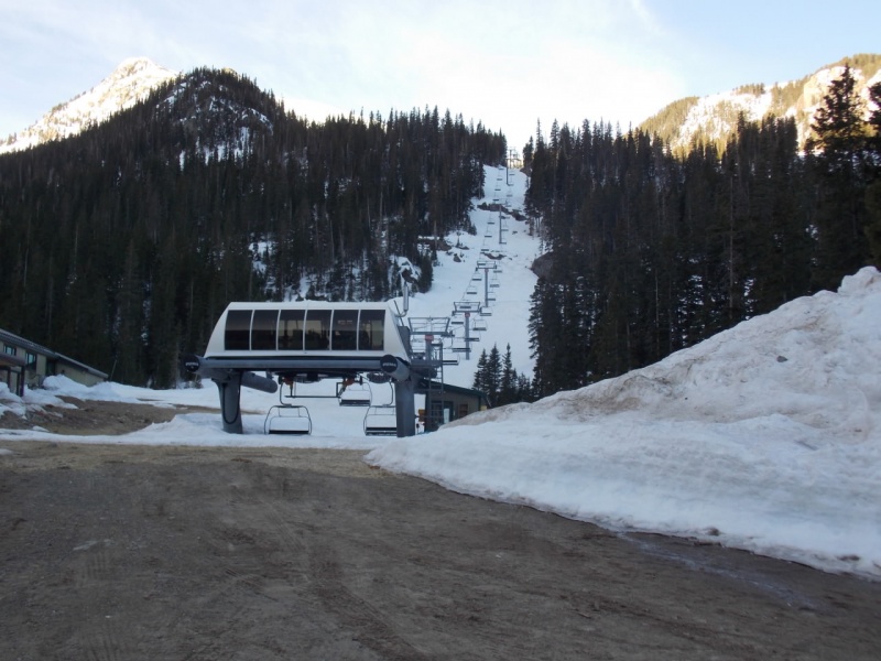
The drive to the trailhead takes you through the Taos Valley Ski Village - what looks like a fun place. Not being a skier, I can't speak to the quality of the runs, but it appears to be a nice area.
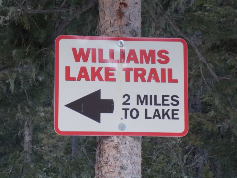
Hard to get lost starting out.
Chair lift
The trail was well packed at the start by snowmobiles, skiers and snowshoers
There had been quite the avalanche some time earlier. Glad I wasn't around then...
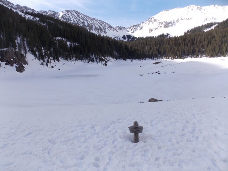
The views sure were nice, tho.
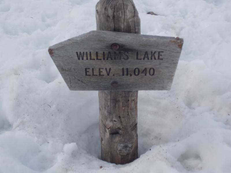
There was supposed to be a sign before the lake that directed you to the trail to the mountain. I am thinking it was probably covered in snow - and if it wasn't, then I just missed it and found myself at the lake.
Williams Lake
2100 more vertical to go...
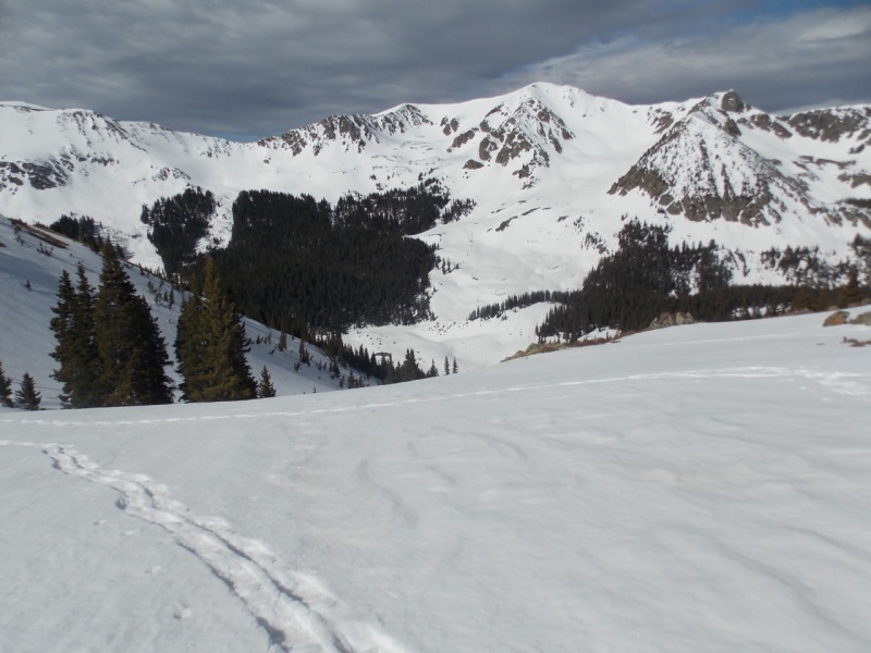
Then, I spotted a gully that had a few old tracks in it and started up.
The views on the way up were really nice.
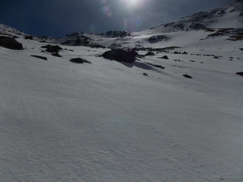
I put on my snowshoes for added traction. (I hadn't brought crampons and wouldn't need them but later on I was glad I'd brought my microspikes)
Looking back
Heading up towards the ridge.
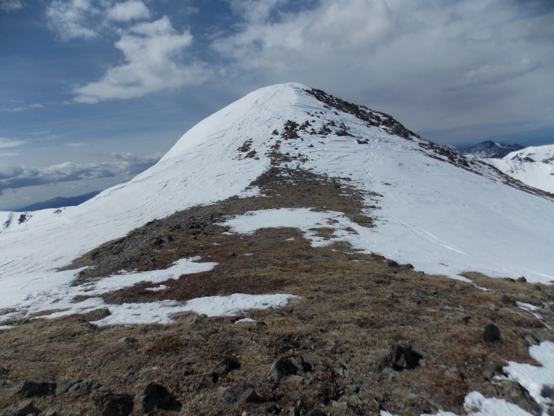
Once on the ridge, the wind was pretty aggresive. Not knock-down aggressive but I was glad I had poles.
On the ridge, looking at the false summit
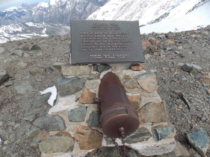
As is always the case in clear weather, the views from the top were fantastic.
As you will hear in the following vid, it was blowing like hell so I stayed just long enough to take some pictures and shoot this vid. You will also see part of the Taos ski area in the vid.
And the views weren't all that bad heading back down...
A fun, fun day in Northern New Mexico!
As always - thanks for taking the time to read this - and please be careful out there.
Thumbnails for uploaded photos (click to open slideshow):
Wheeler Peak didn't disappoint, did it? It looks even nicer with snow. That avalanche would have been rough if you'd been in the wrong place at the wrong time. Congratulations on a great summit. Did you look into Sandia Peak while you were down there?
Doug - Yeah - I'm trying to get in some semblance of shape for the summer season. Slow going, tho.
Brian - I didn't look @ Sandia as we had early dinners every night so I had to be down early and wasn't sure I could make it in time. Boy - can one spend a LOT of money on dinners in Santa Fe! But the food is fantastic there.
That wind sounds fierce. Somewhere, I have a short video with the wind blowing like that on the summit of Guadalupe Peak. The wind definitely makes the summit a hard-earned prize, doesn't it? Nice photos in your trip report as usual...
@Eddie - Yeah - it was bad on the summit but a bit worse on the saddle. But not horrible. The worst I was ever in was on Shavano one winter where it literally blew my sister off her feet. The third time it did it, we turned around (prob 100' from the summit)
@WW - Nope, I'm not a highpointer. Wheeler was just there and GreenhouseGuy had told me sometime back about it and how it was fun. That was only my 3rd high point. Besides that and Elbert, I did manage to make it up the notorious 5.12d route on Hawkeye Point in Iowa as a solo free climb in winter....
I remember this one from the Bull of the Woods route way BITD when I would use the book "Guide to the New Mexico Mountains" to find my way to many NM alpine and desert peaks. I don't think hardly anyone knows or uses this guide book anymore. The guide reads "the ridge around Williams Lake offers much better climbing" (than Bull of the Woods). So your route although shorter is much steeper. And those were the days when high pointing was hardly known as such. And rather than having the wind blowing, I encountered a thunderstorm on the way down and me without a rain jacket. Those were the days.
@Rob - Memories are a good thing - in the end, that's all we have, eh?
@GG - Your comment title brought the Mary Hopkins song to mind - hard to believe that was over 50 years ago. Funny about old books - and it's more a pamphlet rather than a book, I have a CMC guide to the 14ers that is probably 15 pages long. Got it years and years ago. I will have to dig that up - it prob has some "interesting" route descriptions in it. As to the WIlliams Lake route - it was steep after the lake but not really all that bad.
another fun and challenging summer route to wheeler is to hike up kachina from the ski area and then hike around the ridge, hitting about five 12ers along the way.
if you start at the Williams Lake trailhead, hike up the ski slopes to Kachina (12,481) ---> Lake Fork Peak (12,881) ---> UN 12,819 ---> UN 12,728 ---> Simpson Peak (12,976) and over to Wheeler. descend via Williams Lake. difficult class 2. totally fun.
I went down and hiked Wheeler. The snow was solid, I decided to take snowshoes and literally carried them most of the way up and back in my hands since I did not take a backpack. I never used them and did not take my microspikes, did not really need them either. That being said the wind on the ridge was blowing 50 mph, pushing me around, brutal, and I had to use my one pole in my left hand (no right arm/shoulder) to hold me up. I am sure that with the wind chill factor (20 degree temps) it was 15-20 below. Whiteout, could not see much from the summit.
A nice area though from what I could see down by the lake, probably nice in the summer.
The 91 Kachina Road address took me to an electric transformer along the road. It was 9:00 pm and dark. I went up farther and found the one sign just past the ski lift and building on the left side of the road (private steep and dangerous on sign too). Drove back down and finally saw the parking sign for hikers, not sure how I missed it on the way up but I guess I was getting tired, long day of work, 5 hours driving and dark. Parking is at Deer Lane.
One point that might help with the trail. You have the sign by the parking (photo 1) which is pointing in the correct direction but as soon as you start up the road there are signs that say private property, just keep going, it is okay because there are Williams Lake signs further up. Go down the hill, bend around to the left, take the right turn past the ski lift building (dog waste box) going past the building to the next set of signs on the left and right of the road jus past the building. A bit confusing and I had to tell several people the way to the trail on my return to the parking.
It might have been alright but then at 2:00 am some stoners from Texas pulled in and parked right next to me, lights on, talking and slamming doors, geesh. Then another Texas car pulled in just before 5:00 am, since I was wanting an early start their headlights in my window helped I guess. I was the only car there, parked at the last spot and still had the two cars right next to me. Not a good nights sleep.
Al - I got the address from an AllTrails link but could not get my old Garmin car GPS to accept it. It took me to 80 Kachina and I just kept driving till I saw the parking lot. My assumption was that the addy of the parking lot was 91. I did see the private property signs but the road had a lot of footprints on it so I figured it was OK to walk it - no sign said private road that I saw. I'm really sorry to didn't get to see the views - my pics did not do them justice. Sounds like the winds you experienced were a bit worse than mine. I would like to do that peak in the summer, tho - I think it would be a lot of fun.
Glad you made it to the summit despite the wind. I always find it amazing at how something like that can make it break a trip. Great pics Jay. Carson Wilderness is super nice. You need to get down here more often & explore when you can.
Caution: The information contained in this report may not be accurate and should not be the only resource used in preparation for your climb. Failure to have the necessary experience, physical conditioning, supplies or equipment can result in injury or death. 14ers.com and the author(s) of this report provide no warranties, either express or implied, that the information provided is accurate or reliable. By using the information provided, you agree to indemnify and hold harmless 14ers.com and the report author(s) with respect to any claims and demands against them, including any attorney fees and expenses. Please read the 14ers.com Safety and Disclaimer pages for more information.
Please respect private property: 14ers.com supports the rights of private landowners to determine how and by whom their land will be used. In Colorado, it is your responsibility to determine if land is private and to obtain the appropriate permission before entering the property.


")
")
")
")
")
")
")
")
")
")
")
")
")
")
")
")
")
")
")
")
")
")
")
")


