Download Agreement, Release, and Acknowledgement of Risk:
You (the person requesting this file download) fully understand mountain climbing ("Activity") involves risks and dangers of serious bodily injury, including permanent disability, paralysis, and death ("Risks") and you fully accept and assume all such risks and all responsibility for losses, costs, and damages you incur as a result of your participation in this Activity.
You acknowledge that information in the file you have chosen to download may not be accurate and may contain errors. You agree to assume all risks when using this information and agree to release and discharge 14ers.com, 14ers Inc. and the author(s) of such information (collectively, the "Released Parties").
You hereby discharge the Released Parties from all damages, actions, claims and liabilities of any nature, specifically including, but not limited to, damages, actions, claims and liabilities arising from or related to the negligence of the Released Parties. You further agree to indemnify, hold harmless and defend 14ers.com, 14ers Inc. and each of the other Released Parties from and against any loss, damage, liability and expense, including costs and attorney fees, incurred by 14ers.com, 14ers Inc. or any of the other Released Parties as a result of you using information provided on the 14ers.com or 14ers Inc. websites.
You have read this agreement, fully understand its terms and intend it to be a complete and unconditional release of all liability to the greatest extent allowed by law and agree that if any portion of this agreement is held to be invalid the balance, notwithstanding, shall continue in full force and effect.
By clicking "OK" you agree to these terms. If you DO NOT agree, click "Cancel"...
I had driven up early on Wednesday, since I have some vacation to burn. Ryan and Tony would arrive late that night for our trek up to Ice and Island Lakes. I had thought to ascend V5 that evening, if the weather held, but I got to Silverton just a little too late for that.
I then had some time to think about my summer's experiments. I hoped they would be positive, but I had my doubts. Since I was recovering from injury, I didn't want to push my body too hard. Once I thought I was back to normal, the monsoons and the fire smoke were so intermittent, it made planning difficult. If it wasn't the monsoons, then it was the smoke. Neither of which I wanted to travel long distances to deal with. Since going Paleo, my asthma has mostly disappeared. No way I'm going to hike in smoke, and do permanent damage to my lungs, after getting them healthy! So instead of hiking for most of summer, I rode my mountain or new road bike around, and only hiked a couple 14ers by either routes I did 18 years ago, or new ones like Tour d'Abyss. I wasn't sure this would be enough to keep up with Ryan and Tony, but I hoped it would be good enough to at least keep up, sorta. We'll find out tomorrow morning.
After a rough nights sleep for everyone (I had a hard time falling asleep after they arrived), we started driving up the road to the trailhead. At the turn off for the 4x4 road, Tony and Ryan kept going (to visit the facilities) and I went up the road. I got to where I vaguely remembered the trailhead, but it looked incorrect. There were "No Parking" signs. So I kept driving up. Looking at my GPS, I saw I went too far. So I drove back down again. When I saw Tony and Ryan driving up, we discussed our options. We figured it was better to park on the next switchback, than to go to the base. We assumed less elevation gain overall.
After all the morning's delays, we finally got onto the trail, well after sunrise. Good thing we didn't have to worry about storms all day long! It was our reasoning behind doing the biggest day of the trip on Day 1. Weather would get worse as the trip went on.
We made good time up the Ice Lakes, where we surprised some skinny dippers. They were rapidly putting on clothing as we walked up to the lake. The moon was slowly setting behind Pilot Knob, so we hung around watching it set. Waiting for the perfect timing. Don't see that often!
Ice Lakes with a setting Moon
Setting Moon
Once we could tear ourselves away from Ice Lakes, we ascended the easy trail up to Island Lakes for another quick photo session. So much beauty in this area!
Looking back on Ice Lakes BasinNice trail to Island Lakes
Fall is Here
Island lakes with V4 and US Grant peaks
The slope up to the V4 - US Grant saddle didn't look great, but we stuck to the grass and the more firm talus and soon we were on top of it. From there, the use trail is pretty obvious as it goes around the first set of cliffs, and then turns to the left back up a loose talus gully back to the ridge. Another short loose talus - scree section, and then the nice (optional) scramble finish to the summit. Oh the views! Bright blue skies and not much wind. So perfect! We hung out for awhile and snapped photos.
Some flowers remainIsland Lakes from the saddle
Trail from saddle around cliffsTalus gully back to the ridgeRidge to summit
Looking at V3 and US Grant from where you regain the ridge
Summit scramble!
Ice Lakes BasinSummit selfie
Pano southPano north
Far too soon, we had to descend and go for the next summit. Ryan told of us of a rock game him and Brad play where they keep track of the rocks they kick. We let Ryan go first, always, from then on ;)
Descending off the summitApproaching the V4 - US Grant Saddle
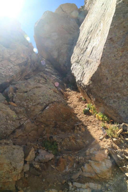
Back at the saddle, the route starts of with loose scree, but isn't too bad, as the slope isn't that steep. Soon we find the crux of the day. The class 4 cliff. This was one of the few areas I researched before hand. The crack on the left was the most appealing, and we all took that option.
Up a loose mini gullyUp a more solid mini gullyFound the crux
Tony going up the class 4 crack
Me topping out the class 4 Photo: Tony
Ryan coming up
Tony at the start of the ledge
More ledge
Ryan and me on the ledge, Photo: Tony
The ledge around to the right wasn't bad at all, and we made short work of that, before we came to the final gully up to the summit. The rock in the gully is quite solid, and soon we were on top of the bicentennial (I only know that because of Ryan).
Gully to summit
Last bit before summit
The weather was holding nicely, and we hung around the summit for a little while. The next section would be more route finding intensive.
Summit pano southSummit pano north
Looking back on V4
Once we started down, we drifted between ridge proper and slightly to the right/south. The scrambling was varied, and we usually had a bunch of options based on our preference. Before the last notch, the guys chose a class 4 - 5.easy descent, while I found a class 3 section that I liked better. Whenever in doubt, look around the area, there might be something easier!
The view to V2 from summit
Tony starting down from the summit, route traverses hereLooking back to US Grant
Ryan pointing the way, next to an inviting crack
Ryan shoulder deep in a narrow crack. Must be comfortable!
Looking back on the terrainA short class 4 wish chimney to descend
Me descending the tight notch - Going to assume those are your fingers Ryan ;)
Looking back up chimneyTerrain forward after a short loose gully descentLooking back after traversing some more
Looking down my class 3 option
Looking back at my class 3 option from the ridgeThe guys exiting the class 4 - 5.easy option
Looking back on the class 3 (left) and the class 4+ center and the cliff face on the east side of US Grant
Looking down the last part of the ridge over to V2
Looking back on US Grant after most of the difficulties
Things started to get a bit silly at this point...
One part of the descent to the V2 saddle, I didn't look around for an easier option, and followed Ryan and Tony down a class 4/5.easy section. Since I'm short, I had to ask for a little foot placement assistance, as well as pushing my ass into the wall a bit. Funny, I had just told the story of the first time I climbed the Second Flatiron, and we did the overhanging descent option. I had to yell at my boyfriend to push my butt into the wall, so I could get my foot onto something. All in front of 2 young impressionable boys...
Me about to get some butt pushing action!
Tony about to descend another loose gully on the traverse.Shadows make the ridge to V2 look moody!
Once at the saddle, we knew all the scrambling was over. Just class 2, so it should all be easy, right? We made it up V2 fairly quickly. and sat on the summit for awhile reveling in the wonderful weather!
US Grant from V2 saddleEasy trail up to V2Ice Lakes and Island Lakes basin from V2
Summit pano south
Summit pano north, with Clear lake below
After awhile on the summit, we finally had to descend. Booo!!!! Quick time back to the saddle, then the "fun" scree descent. I wanted to glissade it, and kind of did in spots. Tony crab walked. Ryan was unperturbed and just pounded on down. Would be the theme to the weekend. Ryan pounding the V gullies like he owned them!
Tony crab walking down the scree.
Island Lake with V4 and US Grant
We took the Island Lakes trail back to the regular Ice lakes trail and made a fairly quick exit out. Only the annoying uphill to get to our Toyota's. From there, the guys decided to go into town for dinner, while I went and found camp, ran my solar panel and cooked my meaty dinner and waited for them.
Trailhead NO MORE :,(
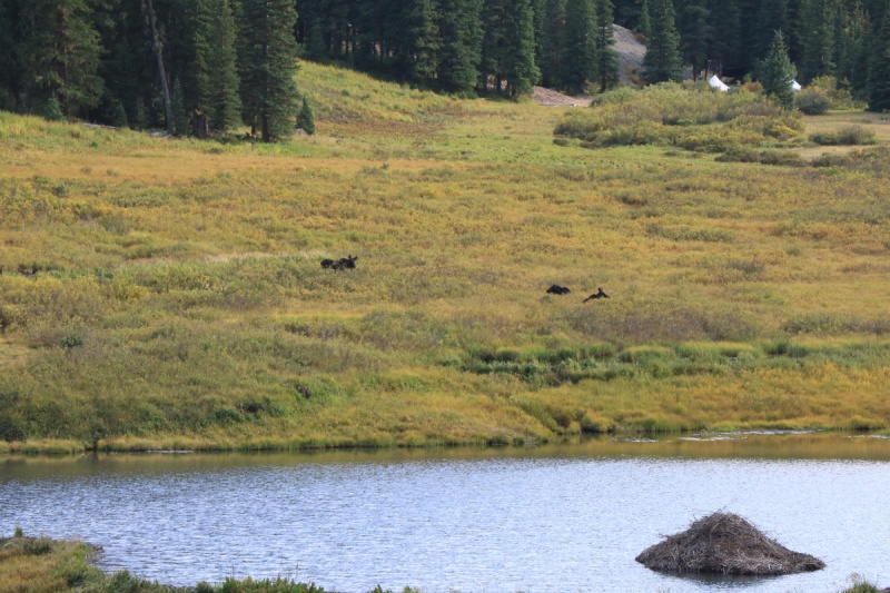
Along the way to the campsite we would stay at for the length of the Labor Day Weekend, I saw a group of 3 moose hanging out around the lakes. At least I brought a reasonably long zoom lens!
Moosies!
So how did my experiment go so far? Biking is not hiking. My cardio seems OK, but my quads need more work. So biking helps, just need more uphill on it. Ugggg not quite comfortable on the road bike for fast descents...
So no parking at that first switchback anymore, huh? Good to know. (I actually didn't get to these peaks on my trip; the updated forecast started looking iffy so I stuck to Yankee Boy Basin for a couple of the bicents there.) Can't wait to get back there!
CarpeDM - Yeah, they must not have liked the crazy parking job people were doing there. Such a great area, I'll be back, even though I've hiked em all!
Doug - The moon was certainly special! Worth hanging out for a little while to get the shots!
This report timed out perfectly, and convinced my wife and I to do V2. Thanks for sharing, it was my first trip to Ice Lakes Basin and I will be back many times!
So you're saying there's an actual TRAIL up V4 (I dealt with traversing the scree gullies on the right/north face), but you scree surfed down V2, which does have a decent trail the Hardrock 100 uses. And the no parking sucks; I realize it's tight there but hope the FS or San Juan County or whoever comes up with a solution. Probably worth posting as a trailhead status report.
Tornadoman - Glad you were able to use our trip while waiting for your Wilson finisher!
jasayrevt - Probably the most photos posted for this route! Too many awesome ones not to share.
Matt - With all the traffic, a trail under the cliffs has formed. It's not a CFI trail, but it worked well until we had to go up. Technically the official trailhead is the one off the 2wd road below, but I guess I'll post an update for those of us who know about the sneak.
Caution: The information contained in this report may not be accurate and should not be the only resource used in preparation for your climb. Failure to have the necessary experience, physical conditioning, supplies or equipment can result in injury or death. 14ers.com and the author(s) of this report provide no warranties, either express or implied, that the information provided is accurate or reliable. By using the information provided, you agree to indemnify and hold harmless 14ers.com and the report author(s) with respect to any claims and demands against them, including any attorney fees and expenses. Please read the 14ers.com Safety and Disclaimer pages for more information.
Please respect private property: 14ers.com supports the rights of private landowners to determine how and by whom their land will be used. In Colorado, it is your responsibility to determine if land is private and to obtain the appropriate permission before entering the property.


")
")
")
")
")
")
")
")
")
")
")
")
")
")
")
")
")
")
")
")
")
")
")
")
")
")
")
")
")
")
")
")
")
")
")
")
")
")
")
")
")
")
")
")
")
")
")
")
")
")


