Download Agreement, Release, and Acknowledgement of Risk:
You (the person requesting this file download) fully understand mountain climbing ("Activity") involves risks and dangers of serious bodily injury, including permanent disability, paralysis, and death ("Risks") and you fully accept and assume all such risks and all responsibility for losses, costs, and damages you incur as a result of your participation in this Activity.
You acknowledge that information in the file you have chosen to download may not be accurate and may contain errors. You agree to assume all risks when using this information and agree to release and discharge 14ers.com, 14ers Inc. and the author(s) of such information (collectively, the "Released Parties").
You hereby discharge the Released Parties from all damages, actions, claims and liabilities of any nature, specifically including, but not limited to, damages, actions, claims and liabilities arising from or related to the negligence of the Released Parties. You further agree to indemnify, hold harmless and defend 14ers.com, 14ers Inc. and each of the other Released Parties from and against any loss, damage, liability and expense, including costs and attorney fees, incurred by 14ers.com, 14ers Inc. or any of the other Released Parties as a result of you using information provided on the 14ers.com or 14ers Inc. websites.
You have read this agreement, fully understand its terms and intend it to be a complete and unconditional release of all liability to the greatest extent allowed by law and agree that if any portion of this agreement is held to be invalid the balance, notwithstanding, shall continue in full force and effect.
By clicking "OK" you agree to these terms. If you DO NOT agree, click "Cancel"...
Thanks Bill and the most recent trip report from 14'ers member "WildWanderer" for info on the route. It was SPOT ON. 2 of my climbing buddies and I decided to give Maroon another try (weathered off a few years ago). We are coming off a 3 day hike of the FPL going CCW so we camped above the bent tree. The weather the entire trip was perfect. A little windy on summit day but turned out perfect and we only saw one soloist on the route as we were descending. This, as with all other trip reports are SUBJECTIVE but I wanted to share our journey as it relates to the 14er's route description.
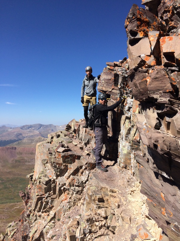
For me, the hardest part of the route is the 2,800 ft ascent & descent of the east slope up to the notch. It's just a grind and burns the quads on the descent. I recommend wearing a helmet the entire time as the steep slope gets rocks moving and its open season for anyone below. Mentally prepare for the grind.
Once you reach the notch at the ridge, the fun begins and you can see the task ahead. Maroon can be intimidating and it should be, take it slow but move with a purpose. The route is straight forward with easily seen carins once you reach the first gully. This is where we used the picture from WildWanderer's report. We took her same line and it is close to what Bill has posted. We were lucky enough that some large white boulders were still in the same place from WW's photo on her report so it was super easy to follow her route. Those boulders could slide at anytime so match the picture with what you are looking at and if its the same, your day just got easier. Crossing the the gullies were not an issue, stay right in the first gully and cross over the loose rubble. We hugged the left side of the second gully and had no issues. The ROBOT description is right on and when going under neath it, look up...not sure how much longer the ROBOT will be there, it appears it could cut loose anytime..tomorrow or a thousand years from now...who knows?
Go up and turn seems to be the mantra for this route and it holds true. There are a few exposed areas with some ledges but I guess it depends on your level of comfort and experience. We never felt concerned but know that conscious thought and movements are required for a safe journey. The route is loose. The ascent was straight forward as you can see the carins the entire route as they are easier to see going up. Descending can be tricky as carins are harder to see as they blend into the mountain. We followed the GPX and only got off course one time on the descent by a few feet. We had the summit to ourselves and stayed for an hour taking in the views and pointing out the FPL and our previous days adventure.
Some Ledges
Looking back on the route near the notch.
Thumbnails for uploaded photos (click to open slideshow):
Thanks for this succinct report. I'm going to study WildWanderer's report carefully before heading up Maroon, one of the last six summits I've got to make.
I'm glad you, WW and others have found the route description helpful! I went back there earlier this summer to update my description and made a few minor changes, like the robot. :)
I hope he doesn't fall over because he's a helpful milestone after exiting the gully section.
I really appreciate this report. Looking at your picture here, "looking back on the route near the notch", looks like the route is well worn and visible. Is this true of most of it as you look ahead a bit?
Caution: The information contained in this report may not be accurate and should not be the only resource used in preparation for your climb. Failure to have the necessary experience, physical conditioning, supplies or equipment can result in injury or death. 14ers.com and the author(s) of this report provide no warranties, either express or implied, that the information provided is accurate or reliable. By using the information provided, you agree to indemnify and hold harmless 14ers.com and the report author(s) with respect to any claims and demands against them, including any attorney fees and expenses. Please read the 14ers.com Safety and Disclaimer pages for more information.
Please respect private property: 14ers.com supports the rights of private landowners to determine how and by whom their land will be used. In Colorado, it is your responsibility to determine if land is private and to obtain the appropriate permission before entering the property.

")
")


