| Report Type | Full |
| Peak(s) |
Maroon Peak - 14,163 feet North Maroon Peak - 14,022 feet |
| Date Posted | 08/14/2018 |
| Date Climbed | 08/13/2018 |
| Author | MaxmimumMills4 |
| Additional Members | jahselassie |
| Bells Traverse |
|---|
|
I had to relocate to Omaha a couple of years ago for school and have put thousands of miles on my car to satiate my love of summits and ridge lines; because of this, all the trips I plan tend to be a little more crazy than the last to make the high last a little bit longer. My usual partners weren't down for the notoriously loose rock on the traverse so I had to look on 14ers for someone wild enough to attempt it. Luckily Scott was equally predisposed to doing dumb stuff and we decided on a 2:30 trailhead meet up. Thats one of my favorite things about hiking 14ers: Scott and I had sent probably 4 texts back and forth and there we were, in the pitch black, ready to attempt a traverse that had gotten the better of climbers far more skilled than we are. We were going S - N as the vast majority of traverse attempts go so we didnt bring anything beyond the standard 14er pack except helmets. Scott had a GPS and distress beacon. Confident and full of young 20-something bravado we struck out on the trailhead towards South Maroon. We chatted about Scott's experience in AmeriCorp and our mutual dislike of all things flat. Our pace was very quick which might be why we missed a couple of signs saying "CAR PARK UP AHEAD". As it turns out we had just done the Maroon Lake Loop as an accidental night time warmup. Well at least were now very familiar with the area around the lake but had lost 20 min. We went back up the trail for about another 30 min and crossed a river with a rock bridge. Just so you know, you should NOT cross a rock bridge. We realized this after looking at the GPS and turned back around. After our second screw up we were very careful to keep an eye on the GPS and finally began our 4,000' slog up the East Face of South Maroon. 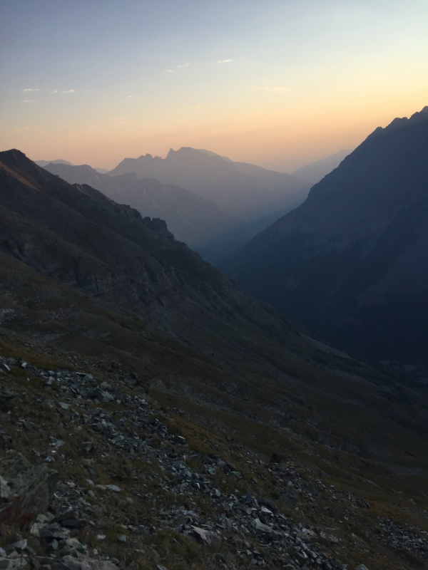 As you can see from the above picture, the smoke from wildfires was rough. It was like hiking through skim milk. I dont know if anyone knows the science on this -- but for some reason the smoke made everything feel incredibly humid which is an experience I have never had in Colorado. We gained the ridge and made our way towards the summit.
You hike through a couple of very easy chutes which Scott and I found very enjoyable
This section is where you get your first taste of the rock quality on the Bells. I know every trip report you have ever read on the Elks has said this, but just to reiterate: the rock is bad. I had several holds break off on this section. I was extremely careful this whole trip to test my holds as should anyone else who is thinking about attempting the traverse.
The rest of this section to the summit is a bit of a blur of bad rock and bad jokes between my partner and I but the standard route description did us well and we summited at around 8:30 which was rather slow but I blame our 2 misadventures that morning as the reason why we were late.
The first thing we noticed at the top is that the down climb to the top of the Bell Cord between the two peaks was WAY down there - definitely more of an elevation loss than I expected. After this point in my head all the moves and decisions we made sorta blend together but I am going to do my best to reference the features listed in the traverse route description to make this as useful as possible for you guys. After descending to the Bell Cord and going a little bit to the left of the ridge, you will locate the dihedral described in the route description. The above picture shows me ascending the crack. Scott and I had no trouble here and the holds were some of the best of the entire route. At the top we climbed to the top of a rock formation which I am 99% sure was Spire #1.
After this we approached the "third and final difficulty" (as it is described in the route description) which was very exposed with bad rock. We went to the right across a thin ledge to reach a route we thought was doable. As you can see from the picture below, a fall here would be deadly.
After this we walked across the ridge to a point were we could see the second spire. I dont really know why anyone would climb directly up the second spire as opposed to simply going right across the ridge but to each their own... After getting across that second spire you are solidly on the West face of North Maroon Peak. There are a on of options here but we found that staying close to the right side of the West face gave us the quickest and safest route to the top.
Above photos taken from the summit of North Maroon. With the traverse over we looked forward to a smooth descent on the North Maroon standard route. NOT. The descent of North Maroon was beautiful but seemed to drag on forever especially when you reach the "Rock Glacier" (my poor ankles). Route finding was not hard but we aren't actually confident that we found the famous chimney. If we did, we down climbed it very easily.
The only thing missing from this picture of Scott is a tiny Simba...
Taken during the descent of N. Maroon. Final Thoughts: With careful route finding and testing every single hold this traverse was exciting and made for a fun day. Scott and I had both summits all to ourselves that day and didn't see anyone else on the traverse. I would not recommend this traverse to anyone who couldn't do a muscle up or who doesn't have knowledge of basic Class 5 moves. We did the traverse in an hour and 45 min. The majority of that time was spent checking everywhere for the best route and testing holds. Thumbnails for uploaded photos (click to open slideshow): ")
")
")
")
")
")
")
")
")
")
")
")
")
")
")
")
")
")
")
")
")
")
")
|
| Comments or Questions | ||||||
|---|---|---|---|---|---|---|
|
Caution: The information contained in this report may not be accurate and should not be the only resource used in preparation for your climb. Failure to have the necessary experience, physical conditioning, supplies or equipment can result in injury or death. 14ers.com and the author(s) of this report provide no warranties, either express or implied, that the information provided is accurate or reliable. By using the information provided, you agree to indemnify and hold harmless 14ers.com and the report author(s) with respect to any claims and demands against them, including any attorney fees and expenses. Please read the 14ers.com Safety and Disclaimer pages for more information.
Please respect private property: 14ers.com supports the rights of private landowners to determine how and by whom their land will be used. In Colorado, it is your responsibility to determine if land is private and to obtain the appropriate permission before entering the property.


