Download Agreement, Release, and Acknowledgement of Risk:
You (the person requesting this file download) fully understand mountain climbing ("Activity") involves risks and dangers of serious bodily injury, including permanent disability, paralysis, and death ("Risks") and you fully accept and assume all such risks and all responsibility for losses, costs, and damages you incur as a result of your participation in this Activity.
You acknowledge that information in the file you have chosen to download may not be accurate and may contain errors. You agree to assume all risks when using this information and agree to release and discharge 14ers.com, 14ers Inc. and the author(s) of such information (collectively, the "Released Parties").
You hereby discharge the Released Parties from all damages, actions, claims and liabilities of any nature, specifically including, but not limited to, damages, actions, claims and liabilities arising from or related to the negligence of the Released Parties. You further agree to indemnify, hold harmless and defend 14ers.com, 14ers Inc. and each of the other Released Parties from and against any loss, damage, liability and expense, including costs and attorney fees, incurred by 14ers.com, 14ers Inc. or any of the other Released Parties as a result of you using information provided on the 14ers.com or 14ers Inc. websites.
You have read this agreement, fully understand its terms and intend it to be a complete and unconditional release of all liability to the greatest extent allowed by law and agree that if any portion of this agreement is held to be invalid the balance, notwithstanding, shall continue in full force and effect.
By clicking "OK" you agree to these terms. If you DO NOT agree, click "Cancel"...
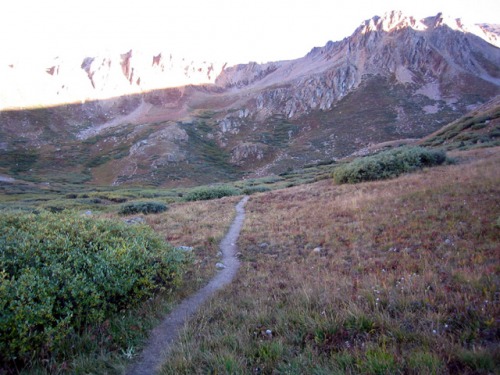
Took the 4WD road from Winfield (straight, not left to Huron); kind of looks like someones driveway. The road was in decent condition; made it just fine in a Hyundai Tucson ... though, it got rougher toward the end and we bottomed out in a couple spots. Still, made it to the register and parked (ironically, a couple Jeep Cherokees didnt go up the last section). Signed in at 7:15 and headed up through the woods, and then travelled along a gully with a raging creek below (to the left). Broke above treeline and into the willows. Some sections were muddy, but it was mostly frozen mud so it wasnt so bad.
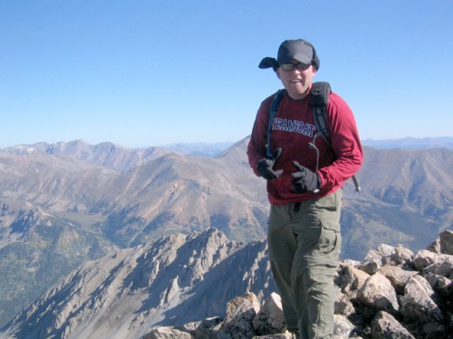
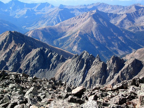
Headed up to the top of the basin on a steep, slippery trail (thank god I brought the trekking poles, as they came in very handy). Crossed the meadow along an easy-to-follow, single-track trail, but then routefinding became more difficult. There were some cairns, but there were multiple-cairned routes, adding confusion. Didnt really matter, though, because it was all UP. I actually thought the summit was at the top ... but it was a big false peak. We then traversed up the long and broad southwest ridge of the true summit (which had another false peak for us to enjoy). The "trail" was kind of difficult to follow on many occasions, but you always knew where you were going. And, if anything, losing the trail only meant climbing more rocks instead of walking. Hit the summit at 9:45 with steady, chilly winds. No clouds, though.
Only passed one couple on the way up. From the summit we counted 6 people climbing up the standard route from La Plata Gulch. Only passed two people on the way back down. Here's a pic from the summit looking south:
Cruised down at a fairly quick pace (jogging on some sections), and made it back to the register at 11:25.
FYI: We used Gerry Roach's map for reference (11.3), but it has some minor inaccuracies that you should look into.
Thumbnails for uploaded photos (click to open slideshow):
Comments or Questions
Caution: The information contained in this report may not be accurate and should not be the only resource used in preparation for your climb. Failure to have the necessary experience, physical conditioning, supplies or equipment can result in injury or death. 14ers.com and the author(s) of this report provide no warranties, either express or implied, that the information provided is accurate or reliable. By using the information provided, you agree to indemnify and hold harmless 14ers.com and the report author(s) with respect to any claims and demands against them, including any attorney fees and expenses. Please read the 14ers.com Safety and Disclaimer pages for more information.
Please respect private property: 14ers.com supports the rights of private landowners to determine how and by whom their land will be used. In Colorado, it is your responsibility to determine if land is private and to obtain the appropriate permission before entering the property.
")
")
")

