Download Agreement, Release, and Acknowledgement of Risk:
You (the person requesting this file download) fully understand mountain climbing ("Activity") involves risks and dangers of serious bodily injury, including permanent disability, paralysis, and death ("Risks") and you fully accept and assume all such risks and all responsibility for losses, costs, and damages you incur as a result of your participation in this Activity.
You acknowledge that information in the file you have chosen to download may not be accurate and may contain errors. You agree to assume all risks when using this information and agree to release and discharge 14ers.com, 14ers Inc. and the author(s) of such information (collectively, the "Released Parties").
You hereby discharge the Released Parties from all damages, actions, claims and liabilities of any nature, specifically including, but not limited to, damages, actions, claims and liabilities arising from or related to the negligence of the Released Parties. You further agree to indemnify, hold harmless and defend 14ers.com, 14ers Inc. and each of the other Released Parties from and against any loss, damage, liability and expense, including costs and attorney fees, incurred by 14ers.com, 14ers Inc. or any of the other Released Parties as a result of you using information provided on the 14ers.com or 14ers Inc. websites.
You have read this agreement, fully understand its terms and intend it to be a complete and unconditional release of all liability to the greatest extent allowed by law and agree that if any portion of this agreement is held to be invalid the balance, notwithstanding, shall continue in full force and effect.
By clicking "OK" you agree to these terms. If you DO NOT agree, click "Cancel"...
Precedent appears to establish a route for combining Square Top Mountain, Argentine Peak, and Mount Wilcox that crosses private property on the Naylor Lake shore (and that is -imho- also suboptimal otherwise). Some have suggested that this trespassing is unavoidable, but reports also indicate that the owners do not react kindly to trespassers. Here I’ll describe 1)a slight variation that avoids trespassing and 2)a more significant variation that would imho be a better choice.
The general idea is to start at the upper Guanella Pass trailhead (for Square Top) and end at the Silver Dollar Lake trailhead; nothing exceeding class 2. With the slog back on Guanella Pass Road, the loop has been described to be ~10-12mi with 4,100-5,000ft elevation gain. That remains the same with the two variations below:
1) Avoid private property by NOT descending all the way to Naylor Lake, and instead do some bushwacking through the forest (after descending some pretty steep slopes; beware not to cliff out). This is the option I took. There was a bunch of deadfall, but the forest is not super dense, also allowing to navigate using the ridgeline to the south as reference (which was good for me, b/c my phone GPS ran out of juice). Without GPS, I ended up hitting the road still within 100 yards of the property boundary… but well out of sight from any of the structures near the lake. (This following report contains a map with indication of the property lines, in addition to a GPS track of the “standard loop”: https://www.14ers.com/php14ers/tripreport.php?trip=14333 ).
2) But, imho, the following is the better option: From Mt Wilcox, trace your steps back to the saddle with Argentine. From there, take an obvious ramp down towards the valley, heading east, and then turn south to reach Murray Lake (as described in this report: https://www.14ers.com/php14ers/tripreport.php?trip=18070 ). From Murray Lake, there is a trail to Silver Lake and then down to the trailhead.
Option 2 requires a short back-track and thus doesn’t make for quite as pleasing of a loop on the map (one reason I didn’t take this option)... but for the actual hiking, it is probably more pleasing: It avoids one of the more unpleasant parts of the “standard loop” of option 1 (down from Wilcox), makes use of an established trail, and adds two alpine lakes.
A remaining not-so-pleasing part of this loop is the slog back up to the Guanella Pass trailhead. Of course this could be avoided with two 2WD vehicles... or with one 4WD vehicle . With the 4WD vehicle, one could start at the upper 4WD trailhead for Silver Dollar Lake instead, and climb Square Top after gaining the Square Top – Argentine saddle from Silver Dollar Lake. With the two 2WD vehicles, one could stash one of them at the lower 2WD trailhead for Silver Dollar Lake (which is just off the Guanella Pass Road).
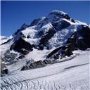
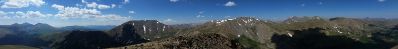
View from Wilcox. Left of center: Square Top; right of center: Argentine. Three bumps far left: Spalding, Evans, Bierstadt; tree bumps on the right: Grays, Torreys, Edwards; further right: Parnassus and Bard.
Thumbnails for uploaded photos (click to open slideshow):
and i like your line from the Silver Dollar Lake TH to Square Top better than my suggestion. (Would still pick my "option 2" for the descent).
Caution: The information contained in this report may not be accurate and should not be the only resource used in preparation for your climb. Failure to have the necessary experience, physical conditioning, supplies or equipment can result in injury or death. 14ers.com and the author(s) of this report provide no warranties, either express or implied, that the information provided is accurate or reliable. By using the information provided, you agree to indemnify and hold harmless 14ers.com and the report author(s) with respect to any claims and demands against them, including any attorney fees and expenses. Please read the 14ers.com Safety and Disclaimer pages for more information.
Please respect private property: 14ers.com supports the rights of private landowners to determine how and by whom their land will be used. In Colorado, it is your responsibility to determine if land is private and to obtain the appropriate permission before entering the property.
")