Download Agreement, Release, and Acknowledgement of Risk:
You (the person requesting this file download) fully understand mountain climbing ("Activity") involves risks and dangers of serious bodily injury, including permanent disability, paralysis, and death ("Risks") and you fully accept and assume all such risks and all responsibility for losses, costs, and damages you incur as a result of your participation in this Activity.
You acknowledge that information in the file you have chosen to download may not be accurate and may contain errors. You agree to assume all risks when using this information and agree to release and discharge 14ers.com, 14ers Inc. and the author(s) of such information (collectively, the "Released Parties").
You hereby discharge the Released Parties from all damages, actions, claims and liabilities of any nature, specifically including, but not limited to, damages, actions, claims and liabilities arising from or related to the negligence of the Released Parties. You further agree to indemnify, hold harmless and defend 14ers.com, 14ers Inc. and each of the other Released Parties from and against any loss, damage, liability and expense, including costs and attorney fees, incurred by 14ers.com, 14ers Inc. or any of the other Released Parties as a result of you using information provided on the 14ers.com or 14ers Inc. websites.
You have read this agreement, fully understand its terms and intend it to be a complete and unconditional release of all liability to the greatest extent allowed by law and agree that if any portion of this agreement is held to be invalid the balance, notwithstanding, shall continue in full force and effect.
By clicking "OK" you agree to these terms. If you DO NOT agree, click "Cancel"...
| Snowmass' S Ridge |
Last Saturday, we made the long drive from Denver to Lead King Basin, going in and out via Marble and not Crystal. There are plenty of condition reports describing that road, so I'll only say make sure you have a vehicle with good ground clearance, and avoid that road in the rain!
TIMES
Lead King Basin to bottom of gully: 3 hours
Climb of gully to top of summit: 3 hours
Summit to base of West Slope: 2.2 hours
West Slope base to Lead King TH: 1.5 hours
There are some great TRs out there on this route by PKR and SkiColorado93, with very detailed beta. I'd recommend anyone doing this route start there, and thanks to those folks for the writeup! I'll supplement their reports with some pieces of info I think are relevant:
-For the most part, the trail is very easy to follow in the dark with headlamps on. I can see how after a rainstorm, this hike would be tough because there is so much vegetation that clusters the trail, and you can easily get soaked. Fortunately, it was a very dry, stable weekend in the Elks.
-The trail split near campsite 4 is obvious, just know to look for it (even in the dark)
-After arriving at Little Gem Lake, we probably took about 10 minutes of wandering to see the appropriate area to climb down to the creek towards the gully slope. I'd recommend just heading straight towards the gullies, and as you head into the area where the creek dips, you'll see a grassy slope on the other side which angles up to the left. Once there, it is very obvious to get to the two gullies
-Take the middle rib between the gullies! I didn't think there were any moves that exceeded Class 3, and the rock is pretty solid. This part does take longer than we were expecting to gain the ridge, I think about an hour.
-Once on the ridge proper, getting to the Blade Rock is very straightforward. The one mistake we made was sometimes favoring the left side of the climb up too much and losing the ridge proper, which didn't really save us any difficulty or time. Doing it again, I'd really try to stay ridge proper for as much as possible.
-On the final part of the ridge (Part 3 according to some TRs) after the flat area, we took the Class 4 slabs up and found them fairly easy and straightforward. The one thing about them that I didn't like, and couldn't see until we had cleared them, is that right at the exit on climber's left there is a tall tower of rock, which has some cracks in it. Considering that mountains move over time, I can see a fracture taking place here. You can see this 'tower' in one of my images below.
-We took the West Slopes down, favoring a fairly prominent rib on climber's right heading down. Maybe we got lucky in our line selection, but overall I found the W Slopes far more stable and solid than I've read everywhere. Yes, it's steep steps down for a lot of vertical, but at no point did I feel like we were going down a completely loose slope.
SUMMARY
Overall, we thought this was a fantastic route. Lead King Basin is jaw-droppingly beautiful, and the hike to the gullies is on a good trail and easy to navigate in the dark. Once at the gullies, the rock is for the most part very solid all the way to the summit. The S-Ridge definitely has some exposure in places, but never for very long and for the most part, even the moves that go Class 4 are pretty straightforward. We thought about going down that route as well, but ended up taking the West Slopes and glad we did for the much faster descent. Definitely one of our new favorites.
Thumbnails for uploaded photos (click to open slideshow):
 The S Ridge from afar")
 Looking up ridge towards summit")
 On Part 2 looking back")
 Slab climbing")
 Coming up Part 1")
 Tower after slabs, with the Class 3 gully option on the right")
 Summit views of Capitol")
 Looking down the W Slopes, rib is on the right")
 Slabs near the waterfall")
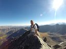
 Success!")
|
Caution: The information contained in this report may not be accurate and should not be the only resource used in preparation for your climb. Failure to have the necessary experience, physical conditioning, supplies or equipment can result in injury or death. 14ers.com and the author(s) of this report provide no warranties, either express or implied, that the information provided is accurate or reliable. By using the information provided, you agree to indemnify and hold harmless 14ers.com and the report author(s) with respect to any claims and demands against them, including any attorney fees and expenses. Please read the 14ers.com Safety and Disclaimer pages for more information.
Please respect private property: 14ers.com supports the rights of private landowners to determine how and by whom their land will be used. In Colorado, it is your responsibility to determine if land is private and to obtain the appropriate permission before entering the property.
 The S Ridge from afar")
 Looking up ridge towards summit")
 On Part 2 looking back")
 Slab climbing")
 Coming up Part 1")
 Tower after slabs, with the Class 3 gully option on the right")
 Summit views of Capitol")
 Looking down the W Slopes, rib is on the right")
 Slabs near the waterfall")
 Success!")