Download Agreement, Release, and Acknowledgement of Risk:
You (the person requesting this file download) fully understand mountain climbing ("Activity") involves risks and dangers of serious bodily injury, including permanent disability, paralysis, and death ("Risks") and you fully accept and assume all such risks and all responsibility for losses, costs, and damages you incur as a result of your participation in this Activity.
You acknowledge that information in the file you have chosen to download may not be accurate and may contain errors. You agree to assume all risks when using this information and agree to release and discharge 14ers.com, 14ers Inc. and the author(s) of such information (collectively, the "Released Parties").
You hereby discharge the Released Parties from all damages, actions, claims and liabilities of any nature, specifically including, but not limited to, damages, actions, claims and liabilities arising from or related to the negligence of the Released Parties. You further agree to indemnify, hold harmless and defend 14ers.com, 14ers Inc. and each of the other Released Parties from and against any loss, damage, liability and expense, including costs and attorney fees, incurred by 14ers.com, 14ers Inc. or any of the other Released Parties as a result of you using information provided on the 14ers.com or 14ers Inc. websites.
You have read this agreement, fully understand its terms and intend it to be a complete and unconditional release of all liability to the greatest extent allowed by law and agree that if any portion of this agreement is held to be invalid the balance, notwithstanding, shall continue in full force and effect.
By clicking "OK" you agree to these terms. If you DO NOT agree, click "Cancel"...
Mt. Harvard (14,420')
Route: Frenchman Creek
RT Distance: 17.1 miles
Elevation Gain: 6,000'
RT time: 16 hours (10:20 to summit)
Members of group: Gary Neben and MarkMadness
Mt. Harvard via Frenchman Creek has been a winter goal of mine, ever since it demoralized me with deep trenching only to the first creek crossing in January 2016. I never attempted it again that season. The first day of winter 2016-2017 I summited Mt. Columbia and looked over at Harvard, taking multiple photos of the ridge conditions and the Frenchman Creek treeline/basin foolishly thinking I'd be coming up that drainage within the next week. Unfortunately the next week I found myself trenching the route only to ~11,050', not long after the Colorado Trail junction. Ten days later me and 3 others headed to Harvard to refresh the trench where we extended the trench to treeline. Ten more days passed with significant snow falling during that time across the whole state, especially in the Sawatch. We hoped our trench wasn't completely buried but we couldn't ignore the fantastic weather window on Wednesday: 15-20 mph winds with bluebird skies. This felt like the first good weather window in 3 weeks so we had to take our shot. Looking at PT ~13,975 from near treeline Almost to treeline
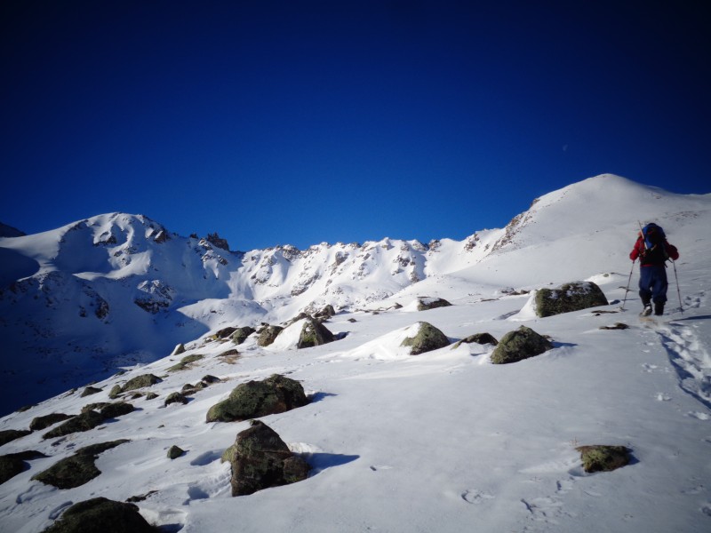
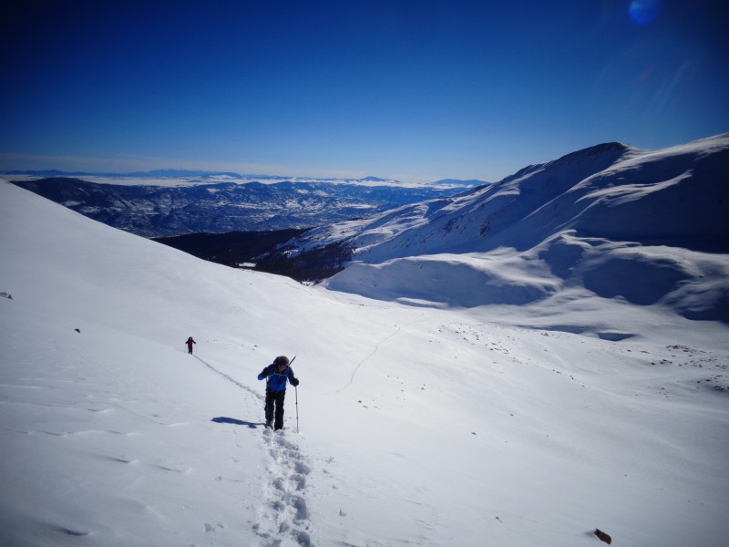
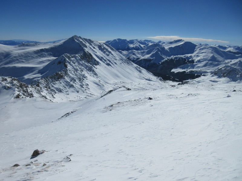
We were shooting for a start time of 3 AM and were on the trail by 3:15. We found some intermittent ski and light snowshoe tracks to the FR 387 junction just over a mile into the route and were soon on our own, following the slight divot in the snow marking the trench that 4 of us set in place 10 days ago. I'm not convinced that the prior trench was all that useful since we didn't sink in that much further if we strayed from the prior trench. We ended up making it to the Colorado Trail junction in just over 3 hours. We had hoped to be able to stay on our prior trench but lost it at around 11,100' and basically followed the path of least resistance (which was more of a path of a little more resistance than necessary) but we made it to treeline eventually by around 8:15 AM. I'd say the path of least resistance stays within the creek at the bottom of the drainage. We went too far to the left (south) and found ourselves dropping elevation slightly to get into the gully that exits treeline. Looking back to treeline Harvard-Columbia Traverse Harvard-Columbia traverse with MarkMadness at right
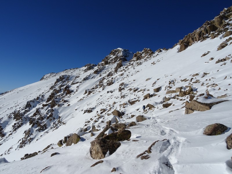
Once we gained the basin we realized we weren't going to be stashing our snowshoes anytime soon. The basin was blanketed in snow making it both a beautiful and demoralizing sight, knowing we would be wearing our snowshoes much higher than we had hoped. We discussed the best route to treeline and decided to gain the ridge between UN 13,374 and Harvard, staying primarily on ribs with intermittent rocks. We were surprised to see no natural slides on any aspects at this point, especially given that yesterday was the first sunny and clear day the Sawatch had seen in a week or two. We stayed on as low angle of terrain as possible as we worked our way to the ridge at ~13,500, slogging through fairly deep snow. Working our way to the ridge Nearing the ridge at ~13,500' The ridge to Harvard from 13,500
Upon reaching the ridge we realized we would need to keep our snowshoes on as the snow was still quite deep on the ridge since winds had been fairly light over the past few days (cant complain about light winds in winter!). We made our way along the ridge on some gentle ups and downs to our final steep slog to PT ~13,975. Looking towards Columbia from the ridge between UN 13,374 and Harvard Nearing PT 13,975 Looking towards Columbia from near PT 13,975
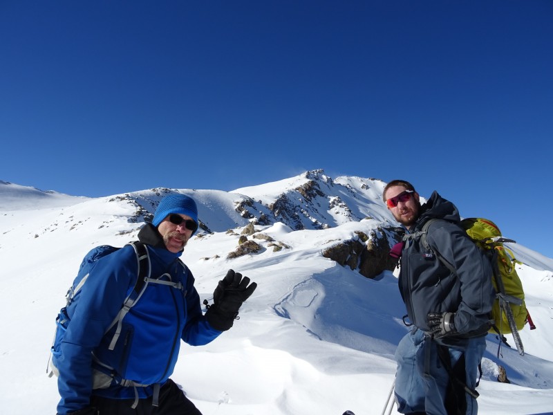
We decided to take the ridge, going directly over the top of PT 13,975. Going directly over this ridge is not recommended in winter if you're on a time crunch. Up until this point we felt we were making relatively good time but lost a good hour or so getting into some more challenging terrain by staying primarily ridge proper. It was mostly class 2/3 with one class 4 downclimb requiring some stem moves. The snow was fairly sugary on this section so we donned microspikes and took out our ice axes which we used to the summit and back to PT 13,975. We eventually made it through the ridge of PT 13,975 to the final summit ridge to Mt. Harvard. One of the scrambling portions near PT 13,975. We went directly over the block at center.
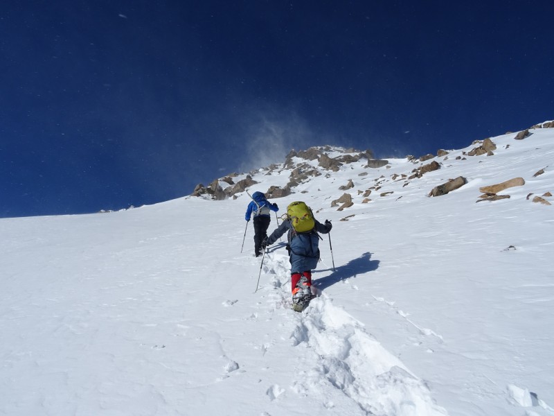
The final summit ridge was less technical at class 2+ with steep semi-loose snow making step-kicking more challenging than we would've liked. There was one portion where we were postholing to our hips. The ridge had lots of mini saddles hidden from view. We eventually summited at 1:40 PM for a total ascent time of 10 hours and 20 minutes. On the descent we retraced our steps to the PT 13,975-Harvard saddle and bypassed the ridge on a snowy bypass which saved us a lot of time. We put on snowshoes around 13,600' and followed our trench back to treeline. Descending the ridge from PT 13,975 to the Harvard-13,975 saddle Gary and I on the summit Mark and I on the summit Snow traverse which avoids the difficulties of the ridge from PT 13975 to the 13975-Harvard saddle Looking at our trench while on the descent, showing how we gained the ridge at 13,500 Trench on the descent to treeline
The descent from treeline to the car felt like it took forever, made even worse by darkness falling upon us by the final creek crossing. We finally made it to the trailhead by 7:20 PM for RT time of 16 hours. It was great to have such great weather with the winds staying below 20 mph and the temperature feeling balmy in the basin when below the ridge. All in all it was one of those great winter days you never forget!
Thumbnails for uploaded photos (click to open slideshow):
Harvard is not easy to climb in the winter and you took a great line. Very impressive in one day. My son and I (I was 57 at the time) took two days to climb this route in January 5 years ago.
I'm sad our previous trench didn't help much though!
Caution: The information contained in this report may not be accurate and should not be the only resource used in preparation for your climb. Failure to have the necessary experience, physical conditioning, supplies or equipment can result in injury or death. 14ers.com and the author(s) of this report provide no warranties, either express or implied, that the information provided is accurate or reliable. By using the information provided, you agree to indemnify and hold harmless 14ers.com and the report author(s) with respect to any claims and demands against them, including any attorney fees and expenses. Please read the 14ers.com Safety and Disclaimer pages for more information.
Please respect private property: 14ers.com supports the rights of private landowners to determine how and by whom their land will be used. In Colorado, it is your responsibility to determine if land is private and to obtain the appropriate permission before entering the property.


 The ridge to Harvard from 13,500")
 Looking at PT ~13,975 from near treeline")
 Almost to treeline")
 Looking back to treeline")
 Harvard-Columbia Traverse")
 Nearing the ridge at ~13,500'")
 Working our way to the ridge")
 Harvard-Columbia traverse with MarkMadness at right")
 Nearing one of many false summits on the final summit ridge")
 Looking towards Columbia from the ridge between UN 13,374 and Harvard")
 Nearing PT 13,975")
 One of the scrambling portions near PT 13,975. We went directly over the block at center.")
 Looking towards Columbia from near PT 13,975")
 Descending the ridge from PT 13,975 to the Harvard-13,975 saddle")
 Gary and I on the summit")
 Mark and I on the summit")
 Snow traverse which avoids the difficulties of the ridge from PT 13975 to the 13975-Harvard saddle")
 Looking at our trench while on the descent, showing how we gained the ridge at 13,500")
 Trench on the descent to treeline")


