Download Agreement, Release, and Acknowledgement of Risk:
You (the person requesting this file download) fully understand mountain climbing ("Activity") involves risks and dangers of serious bodily injury, including permanent disability, paralysis, and death ("Risks") and you fully accept and assume all such risks and all responsibility for losses, costs, and damages you incur as a result of your participation in this Activity.
You acknowledge that information in the file you have chosen to download may not be accurate and may contain errors. You agree to assume all risks when using this information and agree to release and discharge 14ers.com, 14ers Inc. and the author(s) of such information (collectively, the "Released Parties").
You hereby discharge the Released Parties from all damages, actions, claims and liabilities of any nature, specifically including, but not limited to, damages, actions, claims and liabilities arising from or related to the negligence of the Released Parties. You further agree to indemnify, hold harmless and defend 14ers.com, 14ers Inc. and each of the other Released Parties from and against any loss, damage, liability and expense, including costs and attorney fees, incurred by 14ers.com, 14ers Inc. or any of the other Released Parties as a result of you using information provided on the 14ers.com or 14ers Inc. websites.
You have read this agreement, fully understand its terms and intend it to be a complete and unconditional release of all liability to the greatest extent allowed by law and agree that if any portion of this agreement is held to be invalid the balance, notwithstanding, shall continue in full force and effect.
By clicking "OK" you agree to these terms. If you DO NOT agree, click "Cancel"...
I realize this is just another Abyss trip report, but as an engineer, I appreciate data points, and hopefully this beta can be another data point when climbers are looking to tackle this excellent route. I've got a few photos and angles of features that I'd never seen before on a TR, so helpfully they are able to shine more light on the route. Enjoy...
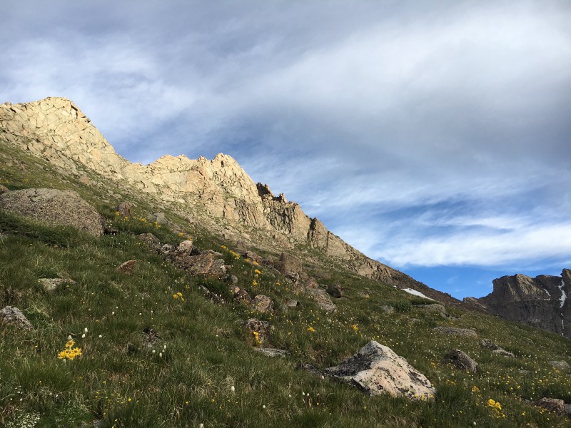
We left Colorado Springs at around 0330 and got to the Mt Evans switchback turnoff just as the sun began to illuminate the days work ahead. What was immediately clear was just how cool the route looked, with the SE Bierstadt ridge just across the valley from where we were at. The prominent points on the ridge were lit up in the morning alpenglow, allowing us to map the features and system of ledges required to grant us passage. We followed a group down to the low point in the saddle, and began working our way on scree and loose dirt. Not much to say about that, other than it sucked.
Adam happier than he should be From the valley up to the ridge Up to the SE ridge of Bierstadt The suck...
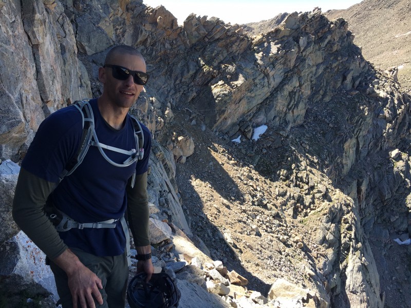
Before long, we gained the top of the ridge, and took a quick breather. We made good time, and were excited to finally be able to start climbing those features I had studied for countless hours leading up to the moment. The rock was solid, with cool moss and grass in between - definitely a nice feature of the Tour and the geology of the area. We quickly ascended the first and second rocky features and before long were standing in front of the famed Pt 13,641. Pictures do not it justice, as it was clearly more prominent and impressive in real life. We studied it briefly, and determined the higher grass ledge was most likely the path of least resistance.
Main point on the ridge
It turned out to be the right call, and we easily found the exit ramp back up to the face. It was pretty exposed, and the ledge was narrow, but the footing was solid, and it was pretty easy to just lean into the headwall.
Ledges Ledge Life
Once back on the headwall, the rest of the feature was relatively straight forward, and included some really fun moves. Staying ridge proper was the only option, so route finding was never an issue.
Crack Off the main point Looking back
Looking back, the SE ridge was easily the highlight of the trip. It was more exposed than the Sawtooth, and was overall just more fun to scramble along. The ledges were for the most part intuitive, and the rock was solid. Aside from the near gail force winds, the conditions were nearly perfect. Next up was Bierstadt, which was an easy class 2 scramble up to it's summit. The reactions we got from the masses on top were priceless. We spent about 5 minutes on top, refueled, and began the next shitty leg of the day, which was the descent off of Bierstadt.
Top of Bierdtadt The suck coming down Bierstadt
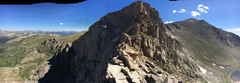
After the trudge down the boulders, we made a quick rock-hop-cross over the remaining snowfield, we finally arrived at the low point of the Sawtooth ridge and scouted our line over the gendarmes. After the SE ridge, they looked fun and easy. They were for the most part.
The gendarmes Sawtooth Pano
Adam was intent on staying ridge proper , and maintained that line better than I was able to. Here's some pics of him on the top of the first big gendarme.
High on Gendarme 1 Higher on Gendarme 1
I chose to take a line bit lower, but was still spicey in it's own right. After crushing the first gendarme, the second presents itself. We went straight at the crack in the headwall on the right, once again finding passage after some class 4 climbing. The route here was not too exposed, just enough to make you think twice before a move.
Gendarme 2 Approaching gendarme 2 Gendarme 2 Crack Top of the gendarme 2 Pano
After this the route became very easy. We downclimbed the gendarme, and got our first look at the Sawtooth ledges. At first it is hard to soak it all in, with the dramatically exposed ledge and quick elevator drop off of. However, the route was straight forward, and the ledge was always wider than it looked from a distance.
Obligatory ledges Ledge Pano Ledge Another pano
The next part of the route was purgatory. We already tackled all the fun features, now the rest of the route consisted of a hike for several miles over to the summit of Mt Evans. We went low and contoured W. Evans with the rest of the pack. The switchbacks up to the summit were easily the worst part of the day. There was no honor in climbing these - Adam and I both highly recommend doing a straight boulder hop up the final 100' to the top. We finally arrived at the summit of Evans with little fanfare or feeling of accomplishment. We were just happy to be close the truck, and snapped a few shots from the top rock after waiting in line with the tourists attempting to climb the high point.
Here's how we felt...
Evans Evans
We eventually found our way off the summit, down to the hordes in the parking lot and began. We cut a beeline to the truck, cutting the switchbacks until we arrived at the truck roughly 7 hours later. We made good time, with hardly any stops, but chose more demanding lines when possible. This absolutely added to the overall route time, but we enjoyed it for the most part.
Anyways, takeaways from the trip... To compare to my previous class 3 climbs on the Lindsey ridge and Kelso ridge. This route held some fun moves and massive exposure at times, but I felt like the pucker factor on Kelso was more intense. The exposure on Lindsey was over really quick, but was my first class 3/4 so felt more intent than it probably was. Overall, this was a fun route, away from the crowds, was spicey at times, and I highly recommend it. Start early, as once you drop into the valley you are committed, and weather on this route often leads to dangerous situations.
Thumbnails for uploaded photos (click to open slideshow):
you got some great shots on the sawtooth. I have had this one on the short list for a while. Your report makes me want to bump it to the top of the list. Thanks for writing up
@Double Oh Seven, I had been eyeing this route for years too! It was such a great route, I couldn't imagine doing either peak, or even the sawtooth, without making a lap of the Tour. Plus it offers great scrambling close to home!
is completely unnecessary. I never tire of quality accounts like this, even after doing the route a couple years ago. And I think you did succeed in providing some different perspectives on aspects of the terrain. I also think your detailed assessment of the route, both the sportier and tamer parts, is spot on. Congrats on a great day in the mountains, and thanks for the excellent TR.
I love reading through TRs like yours. Guess I just like all the details. I did the "Tour" by myself (including a side trip up Mt. Spalding) in 2000 or 2001. I had an old Roach book and no knowledge of what the SW ridge of Bierstadt was about. What a day! Still, one of my favorite trips.
Caution: The information contained in this report may not be accurate and should not be the only resource used in preparation for your climb. Failure to have the necessary experience, physical conditioning, supplies or equipment can result in injury or death. 14ers.com and the author(s) of this report provide no warranties, either express or implied, that the information provided is accurate or reliable. By using the information provided, you agree to indemnify and hold harmless 14ers.com and the report author(s) with respect to any claims and demands against them, including any attorney fees and expenses. Please read the 14ers.com Safety and Disclaimer pages for more information.
Please respect private property: 14ers.com supports the rights of private landowners to determine how and by whom their land will be used. In Colorado, it is your responsibility to determine if land is private and to obtain the appropriate permission before entering the property.


 From the valley up to the ridge")
 Adam happier than he should be")
 Up to the SE ridge of Bierstadt")
 The suck...")
 Main point on the ridge")
 Ledges")
 Crack")
 Off the main point")
 Looking back")
 Top of Bierdtadt")
 The suck coming down Bierstadt")
 The gendarmes")
 Sawtooth Pano")
 High on Gendarme 1")
 Higher on Gendarme 1")
 Gendarme 2")
 Approaching gendarme 2")
 Top of the gendarme 2")
 Pano")
 Obligatory ledges")
 Ledge Pano")
 Ledge")
 Another pano")
 Ridge pano")
 Evans")
 Evans")
 Sheep")
 Crack")
 Gendarme 2")
 Gendarme 2")
 Ledge Life")


