Download Agreement, Release, and Acknowledgement of Risk:
You (the person requesting this file download) fully understand mountain climbing ("Activity") involves risks and dangers of serious bodily injury, including permanent disability, paralysis, and death ("Risks") and you fully accept and assume all such risks and all responsibility for losses, costs, and damages you incur as a result of your participation in this Activity.
You acknowledge that information in the file you have chosen to download may not be accurate and may contain errors. You agree to assume all risks when using this information and agree to release and discharge 14ers.com, 14ers Inc. and the author(s) of such information (collectively, the "Released Parties").
You hereby discharge the Released Parties from all damages, actions, claims and liabilities of any nature, specifically including, but not limited to, damages, actions, claims and liabilities arising from or related to the negligence of the Released Parties. You further agree to indemnify, hold harmless and defend 14ers.com, 14ers Inc. and each of the other Released Parties from and against any loss, damage, liability and expense, including costs and attorney fees, incurred by 14ers.com, 14ers Inc. or any of the other Released Parties as a result of you using information provided on the 14ers.com or 14ers Inc. websites.
You have read this agreement, fully understand its terms and intend it to be a complete and unconditional release of all liability to the greatest extent allowed by law and agree that if any portion of this agreement is held to be invalid the balance, notwithstanding, shall continue in full force and effect.
By clicking "OK" you agree to these terms. If you DO NOT agree, click "Cancel"...
Snowmass Mountain (14092')
Feb 20-21, 2015
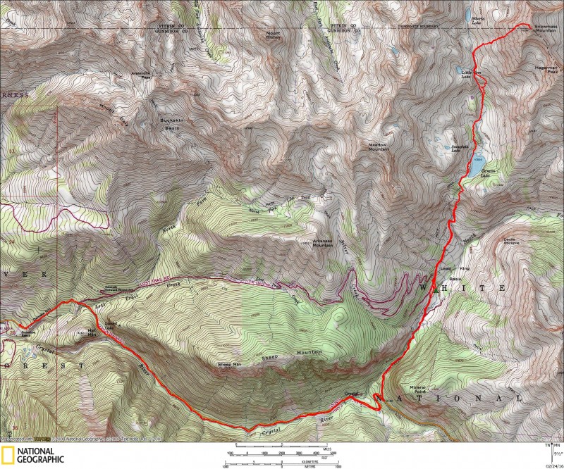
Via Lead King Basin/West Face
23.3 miles, 6900' gain
Climbing 14ers in winter is a highly rewarding goal, but with it comes a multitude of challenges and test of sheer will. Over the years that I have worked on them, they have become "easier" to some extent because of the proliferation of information over the internet. We now have access to fairly accurate point forecasts for a specific mountain area, avalanche forecasts, snow depth information, trip reports, and available trenches to poach! What was a daunting task 10 years ago is much "easier" now, but "easier" is a relative term. No matter what conditions you face, climbing Snowmass in winter is brutal! It doesn't get climbed much in winter, and for good reason. It's a lot of time in the pain cave!
It's been a frustrating winter for folks pursuing Elk 14ers, and I was beginning to think I wouldn't get a new one. A few weeks ago, we were hoping to go for Snowmass as a plan B, but the forecast leaked and we had to bail. Back in March 2010, I attempted Snowmass with Dwight and the Meisers, but we turned around at 13K due to uncertain weather and questionable snow on the upper face. There are generally few good conditions windows to climb Snowmass safely in winter, so one must be patient. A long dry spell and a successful, impressive dayhike by Dad Mike's crew the previous weekend encouraged us to give it a shot. We form a tag team of Greg, Kevin, Sarah, Jeff, Rob, and myself. Jeff and Rob leave a bit later and we hike independently most of the trip. Road split to Lead King Basin
Pack In to Lead King-7.3 miles, 1800' gain
I-70 was closed due to a rockslide in Glenwood Canyon, so Kevin, Sarah, and I spent the night in Gunnison to break up the long journey to the "trailhead." The winter route on Snowmass is via Lead King Basin from the south, but the road to Crystal is typically not plowed beyond the Snowshoe Ranch just east of Marble at 8100'. How demoralizing! We set out at 10am with hopes of getting to the summer trailhead or beyond. It's quite warm and we make good time up the shelf without snowshoes for awhile. The views distract us from the task at hand, and it feels more like spring! This road is prone to avalanches, and we cross a couple of old, wet slide debris. An impressive chunk of ice that broke off a formation above litters the road, over 10 feet high!
Huge ice block on the road!
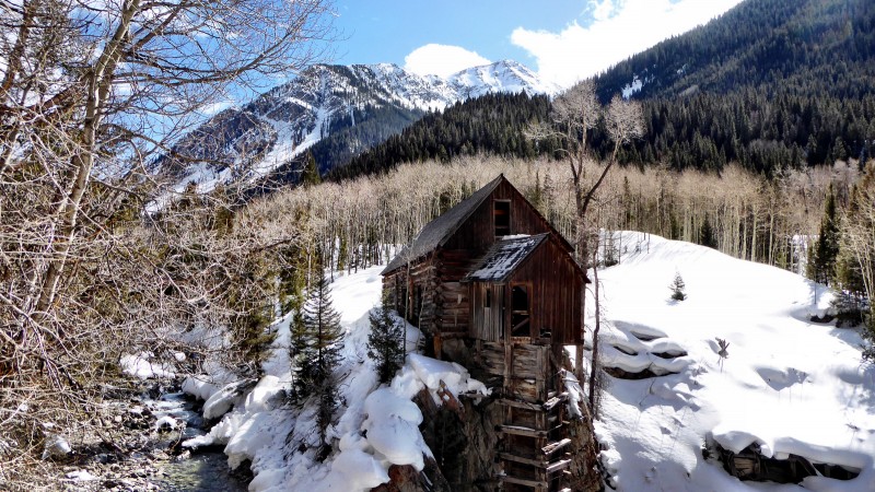
The annoying aspect of the trek to Crystal is you gain only about 800' while losing some elevation on a couple big hills. Those hills are going to bite on the slog out. We make good time to the Crystal Mill enjoying the nice trench and take a lunch break there. It's a treat to see the mill in winter!
Crystal Mill
Rejuvenated from lunch, we press on for the steeper grunt to Lead King Basin. The road climbs the east side of a steep drainage, and one must be confident with the snow conditions to press on as there are a couple suspect avy slopes to cross. The avy rating today is green and we don't see or hear any signs of instability. We get our first views of Snowmass, and they are inspiring to say the least! The scenery is stunningly Alps-like.
Road to Lead King Basin
We press on to the summer trailhead and after some scouting around, we decide to camp below the TH closer to the creek at 9600', arriving at around 2:30. I set up my tent, refuel, and wait for the snow to firm up a bit to see if I can bust a trench up the headwall to Geneva Lake.
Camp at 9600'
My friend Dwight is ahead of us scouting Maroon in Fravert Basin, so I improve his track. I leave his track at the base of the headwall and it's very slow going up soft snow. I get to 10.4K (right side of the waterfall) after an hour and call it good. The snow will be very firm in the morning, so no need wasting energy wallowing any farther now.
Headwall to Geneva Lake
I get back to camp and Greg already has water ready for me. The Summit Lounger is such a nice guy! I find out that Jeff and Rob are planning on a 1am start time as they have to be back to work on Monday. I think they ended up starting at 2. Ouch! The rest of us shoot for a more "leisurely" 4:30 start time with hopes of packing out that same day if we're not too slow. We retire early and the night is warm, so I sleep well.
Summit Day and Pack Out - 16 miles, 5100' gain
As is often the case in winter, we all set off at different times as we take off when ready with heading out first. I leave around 4:45. The snow is firm and we make good time with the track in place. It's mentally demoralizing going up that steep headwall in the dark, but I know what to expect. The snow is very firm and the heel elevators on my MSR's save me a lot of effort. We enjoy the nice track set by Jeff and Rob as light starts to hit mighty Snowmass above. Upper Lead King Basin is a magical place in winter, and it's great to be back!
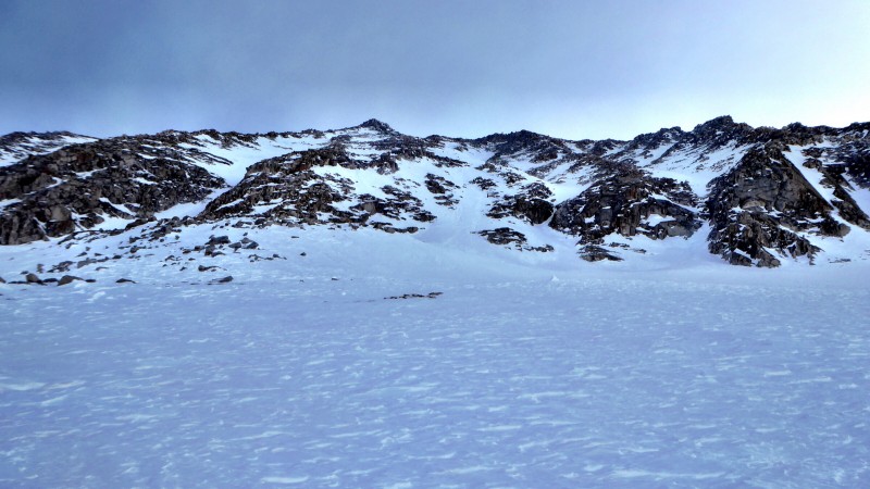
The winter route on Snowmass is generally via a rib to the south of the summer west face route. In 2010, we brought a rope and climbed a low 5th class section of mixed snow and rock. The snow is in better condition this time, so we stay on snow to split the cliff band and then traverse right to the rib.
Apron to the west face
We end up going at our own paces to maximize efficiency on the route since we want to get down as soon as possible before the snow heats up too much. Greg and Jeff kick in some nice bucket steps ahead of us, and I feel like I am cheating!
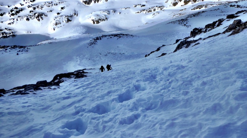
Steep snow splitting initial cliff band
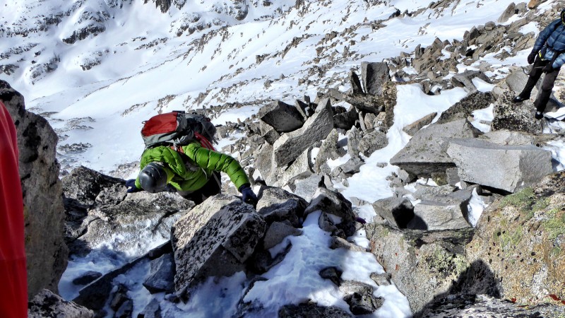
The going slows down a lot though as we gain the rib as we now deal with mixed snow and rock in crampons. There's enough trap door snow that it's more efficient to stick to the rock, but conditions are far better than I expected. In hindsight, it would have been quicker to just take off the crampons above the initial steep snow section.
The rib goes on and on as we make slow but steady progress. Some of us go with crampons and some without. The summit comes into view and it looks a long way away, but it's only a matter of time before we get up this beast with only a bit of a breeze and blue skies. The rib goes at 4th class if you stay on it, with easier lines to the left. We finally hit the ridge and traverse over to the summit block, which I don't remember much about from my first and only visit way back in 2005 via the S Ridge. I try to stay on the ridge proper, but I don't commit to the final move as it would be very awkward in crampons with major air over the east face! I take off my crampons and do the less exposed ledge traverse to climbers right, which is totally dry. Greg has been waiting for awhile, while the rest of us summit pretty close together. I feel like I was in a time warp, because it's already 11:45! We couldn't have asked for better weather or conditions, but we keep our stay fairly short as we don't want to be descending steep snow too late.
Lower rib
Rob scrambling on rib
Summit in view
Rob scrambling near summit
Summit ridge
Summit shot 1 because I couldn't figure out my timer
Summit shot 2
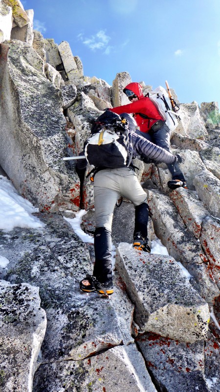
The downclimb of the crux is a bit trickier than I thought it would be, so we give each other spots.
Kevin P on crux downclimb
Rob on crux downclimb
The descent of the rib is more annoying going down than up as it is more difficult to stick to the rocks, so you have to take extra care not to twist an ankle in the trap door snow.
Looking south to Geneva Lake
Kevin P and Sarah on initial descent
We plunge step some snow when we can and get to the steepest snow at the bottom of the face above the initial cliff bands. Sometimes it would be prudent to rappel over the cliff band with suspect snow later in the day, but we feel confident with the conditions and follow the bucket steps down. The snow is soft, but we don't feel like it is going anywhere. I am pumped to be done with the hard stuff, but we haven't even hit the real pain cave, yet!
Elk glory
Initially I was planning on packing out Monday morning, but none of us feel too hammered, so we decide to pack out. The descent of the headwall is a bobsled run with the softening snow. It is a test of balance to stay on your feet! I am back to camp at 4:40 and I pack up slowly dreading the death march out. It feels great to take in the world class scenery on the way down with the tough part of the climb over.
Heck of a moat!
Near Little Gem Lake
Snowmass and Hagerman from Geneva Lake
I survived Truck Peak!
It takes me an hour to pack up and the descent is cruiser until we come to the Crystal Mill. Some deranged soul thought it would be a good idea to day hike to the mill in the dead of winter with no snowshoes! They have totally obliterated the trench, and it feels like we're going slower downhill than uphill trying to avoid all the postholes! I wipe out and do a faceplant, tent poles flying out of my pack. Some of you know I'm not a cussing man, but a frickin jack$%# bomb ensues. Good thing Greg is not around to hear it! The moonlight and the sound of the stream below passes the time, but there are two killer back to back hills that drop some hurt on me! I'm about to go delirious before finally seeing the road split where the snowmobile track starts. Kevin, Sarah, and I finally arrive at the car at 9pm. Snowmass is an epic trip in winter regardless of what good fortune you encounter!
Thumbnails for uploaded photos (click to open slideshow):
I thought the start time was 5 AM... 2/25/2016 11:13am
That is why I didn't stir until 4:25 and had to play catch up all day. :oops: Thanks to all for laying a cruiser trench though. It was great to hang with "The Mick" up there. I hope he's not Irish and takes that the wrong way...
There were three slides paths on the road to the Crystal Mill along with that widow maker chunk of ice. Then you've got the long traversing slope above Crystal and two headwalls before you get to the mountain. Not exactly window shopping terrain.
I have never been around that much inaccessible water with all the snow bridges and whatnot. I did obtain water under the bridge at the entrance to lead king but it was habanero to say the least and not recommended.
Mr. Bluebird delivered this weekend. Thanks for the writeup, Kevin. I wholeheartedly approve of this TR...
It was truly amazing climbing Snowmass with you guys. I really enjoyed the experience except for the drive home after! Excellent job on the trip report Kevin.
Getting to Snowmass in the winter is a remarkable accomplishment. The Elk Range is very inspiring and challenging in its own unique way. This is a great descript write-up of the route and adventure. Love the photos as well. Quite impressive, be extremely proud of the endeavor! Thanks a lot for posting. Stay ambitious and driving towards the big goals
Can't we just do a nice easy hike sometime, Kevin B.? :D
But seriously, while this trip certainly had many moments of suffering, it was worth the time spent in the pain cave. We got so lucky with conditions and weather, not to mention the broken trail courtesy of Dad Mike & Co.
Jeff & Rob, very nice to finally get to meet/hike with you guys. Us winter 14er crazies need to stick together, right?
Thanks for the write-up, Mr. Bluebird! And thanks to Summitlounger for (once again) chilling on the summit while the rest of us mere mortals made our way slowly up.
Looks like an ideal window and an ideal crew. Nice work guys! Kevin, a destroyed trench/skin track after a day like that would draw unsavory words out of just about anyone. Don't sweat it :P
Nothing wrong with poaching good trenches and buckets as long as you give credit and buy the first couple rounds until they forget why you are paying! What an amazing looking weekend for the snow climb! Congratulations all!
Caution: The information contained in this report may not be accurate and should not be the only resource used in preparation for your climb. Failure to have the necessary experience, physical conditioning, supplies or equipment can result in injury or death. 14ers.com and the author(s) of this report provide no warranties, either express or implied, that the information provided is accurate or reliable. By using the information provided, you agree to indemnify and hold harmless 14ers.com and the report author(s) with respect to any claims and demands against them, including any attorney fees and expenses. Please read the 14ers.com Safety and Disclaimer pages for more information.
Please respect private property: 14ers.com supports the rights of private landowners to determine how and by whom their land will be used. In Colorado, it is your responsibility to determine if land is private and to obtain the appropriate permission before entering the property.
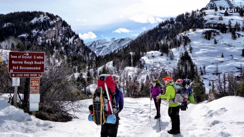


 Road split to Lead King Basin")
 Huge ice block on the road!")
 Crystal Mill")
 Road to Lead King Basin")
 Camp at 9600'")
 Headwall to Geneva Lake")
 Apron to the west face")
 Steep snow splitting initial cliff band")
 Lower rib")
 Rob scrambling on rib")
 Summit in view")
 Rob scrambling near summit")
 Summit ridge")
 Summit shot 1 because I couldn't figure out my timer")
 Summit shot 2")
 Kevin P on crux downclimb")
 Rob on crux downclimb")
 Looking south to Geneva Lake")
 Kevin P and Sarah on initial descent")
 Elk glory")
 Heck of a moat!")
 Near Little Gem Lake")
 Snowmass and Hagerman from Geneva Lake")
 I survived Truck Peak!")
")


